Next round of severe weather 7th May Onwards?
Moderator: S2k Moderators
Forum rules

The posts in this forum are NOT official forecast and should not be used as such. They are just the opinion of the poster and may or may not be backed by sound meteorological data. They are NOT endorsed by any professional institution or STORM2K.

Re:
CrazyC83 wrote:That cell could EASILY put down a strong or violent tornado.
Now that it's getting away from the radar site, I'm starting to agree.
0 likes


-
Dave

- Retired Staff

- Posts: 13442
- Age: 75
- Joined: Tue Aug 01, 2006 3:57 pm
- Location: Milan Indiana
- Contact:
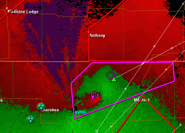
BULLETIN - EAS ACTIVATION REQUESTED
TORNADO WARNING
NATIONAL WEATHER SERVICE NORMAN OK
352 PM CDT MON MAY 10 2010
THE NATIONAL WEATHER SERVICE IN NORMAN HAS ISSUED A
* TORNADO WARNING FOR...
NORTHERN GRANT COUNTY IN NORTHERN OKLAHOMA...
NORTHWESTERN KAY COUNTY IN NORTHERN OKLAHOMA...
* UNTIL 430 PM CDT
* AT 351 PM CDT...A LARGE...TORNADO WAS LOCATED 5 MILES
NORTHWEST OF MEDFORD...MOVING EAST AT 55 MPH.
* LOCATIONS IN THE WARNING INCLUDE BLACKWELL LAKE...BLACKWELL...
BRAMAN...CHILOCCO...DEER CREEK...MEDFORD...NARDIN...PECKHAM...
RENFROW AND WAKITA.
THIS INCLUDES INTERSTATE 35 BETWEEN MILE MARKERS 221 AND 235.
PRECAUTIONARY/PREPAREDNESS ACTIONS...
IN ADDITION TO A TORNADO THREAT... THIS STORM LIKELY CONTAINS
DAMAGING HAIL TO THE SIZE OF BASEBALLS OR LARGER.
TAKE COVER NOW. LEAVE MOBILE HOMES AND VEHICLES. IF POSSIBLE...MOVE
TO A BASEMENT OR STORM SHELTER. OTHERWISE MOVE TO AN INTERIOR ROOM OR
HALLWAY ON THE LOWEST FLOOR. STAY AWAY FROM WINDOWS AND OUTSIDE
WALLS.
THIS IS AN EXTREMELY DANGEROUS AND LIFE THREATENING SITUATION. IF YOU
ARE IN THE PATH OF THIS LARGE TORNADO... TAKE COVER
IMMEDIATELY. A BASEMENT OR STORM SHELTER IS BEST. OTHERWISE...TAKE
COVER IN AN INTERIOR CLOSET OR BATHROOM AWAY FROM OUTSIDE WALLS AND
WINDOWS. COVER YOUR HEAD WITH PILLOWS AND BLANKETS.
&&
0 likes
-
CrazyC83
- Professional-Met

- Posts: 34315
- Joined: Tue Mar 07, 2006 11:57 pm
- Location: Deep South, for the first time!
Cap holding up south of I-40 but for how much longer?
MESOSCALE DISCUSSION 0511
NWS STORM PREDICTION CENTER NORMAN OK
0340 PM CDT MON MAY 10 2010
AREAS AFFECTED...PARTS OF WRN/CNTRL OK
CONCERNING...TORNADO WATCH 147...
VALID 102040Z - 102245Z
THE SEVERE WEATHER THREAT FOR TORNADO WATCH 147 CONTINUES.
A CAPPING ELEVATED MIXED LAYER AND MID/UPPER-LEVEL SUBSIDENCE APPEAR
LIKELY TO CONTINUE AT LEAST INHIBITING CONVECTIVE DEVELOPMENT TO THE
SOUTH OF THE 90 KT CYCLONIC...WESTERLY 500 MB JET STREAK NOSING EAST
OF THE TEXAS PANHANDLE REGION LATE THIS AFTERNOON.
HOWEVER...LOCALLY ENHANCED SURFACE HEATING/LOW-LEVEL CONVERGENCE
COULD BECOME SUFFICIENT FOR SUSTAINED DISCRETE STORM DEVELOPMENT
ALONG THE DRY LINE AS IT ADVANCES TOWARD THE I-35 CORRIDOR OF
CENTRAL/SOUTHERN OKLAHOMA BETWEEN NOW AND 00Z. THE BOUNDARY LAYER
ALONG AND EAST OF THE DRY LINE HAS BECOME VERY UNSTABLE WITH STEEP
MID-LEVEL LAPSE RATES...STEEPENING LOW-LEVEL LAPSE RATES AND UPPER
60S SURFACE DEW POINTS CONTRIBUTING TO CAPE ON THE ORDER OF
3000-4000 J/KG. IN THE PRESENCE OF STRONG DEEP LAYER AND LOW-LEVEL
SHEAR...TORNADOES ARE POSSIBLE...IN ADDITION TO THE RISK FOR VERY
LARGE HAIL AND DAMAGING WIND GUSTS.
..KERR.. 05/10/2010
ATTN...WFO...OUN...
LAT...LON 34249918 35019884 35929868 36509843 36599780 36449728
35509731 34519758 33929803 34249918
0 likes
Re: Next round of severe weather 7th May Onwards?
Large tornado would be a good call.
If you like the NROT values in GR2A, the storm has the following values:
1402 ft - 2.1
2167 ft - 1.6
2830 ft - 2.7
3901 ft - 2.7
5179 ft - 1.9
Looks like a decent sized tornado impacting that area.
If you like the NROT values in GR2A, the storm has the following values:
1402 ft - 2.1
2167 ft - 1.6
2830 ft - 2.7
3901 ft - 2.7
5179 ft - 1.9
Looks like a decent sized tornado impacting that area.
0 likes
-
apocalypt-flyer
- Category 1

- Posts: 468
- Joined: Sat Aug 27, 2005 11:51 am
Re: Next round of severe weather 7th May Onwards?
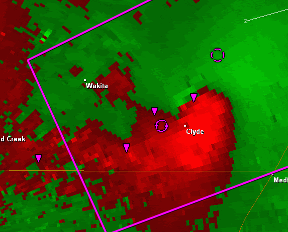
This could get nasty. It's probably fairly hard to see hidden in a lot of rain.
Medford and Clive in the firing line. Stay safe everyone.
Medford and Clive in the firing line. Stay safe everyone.
0 likes


Return to “USA & Caribbean Weather”
Who is online
Users browsing this forum: SnowyOwl31 and 112 guests