Tornado outbreak February 28-March 2, 20 dead, EF4 in Kansas
Moderator: S2k Moderators
Forum rules

The posts in this forum are NOT official forecast and should not be used as such. They are just the opinion of the poster and may or may not be backed by sound meteorological data. They are NOT endorsed by any professional institution or STORM2K.

Wow! This is going to an amazing severe weather day. All of you in the SE be very cautious today. Lets hope no lives are taken with this major severe weather event.
0 likes
The following post is NOT an official forecast and should not be used as such. It is just the opinion of the poster and may or may not be backed by sound meteorological data. It is NOT endorsed by any professional institution including storm2k.org For Official Information please refer to the NHC and NWS products.

the tornado watch does not have the P.D.S. wording with it in my area according to Memphis. Did I somehow overlook it??
http://www.srh.noaa.gov/showsigwx.php?w ... nado+Watch
http://www.srh.noaa.gov/showsigwx.php?w ... nado+Watch
0 likes
-
GeneratorPower

- S2K Supporter

- Posts: 1648
- Age: 46
- Joined: Sun Dec 18, 2005 11:48 pm
- Location: Huntsville, AL
Local version doesn't have the PDS wording. Go to http://www.spc.noaa.gov and click "Watches"
0 likes
Grenada and Carrol county in west central Ms are under severe T'storm warnings.
http://www.srh.noaa.gov/showsigwx.php?w ... rm+Warning
http://www.srh.noaa.gov/showsigwx.php?w ... rm+Warning
0 likes

Oh no.
Storm report from earlier this morning:
Date: Mar 01 13:00:00 UTC
Type: TORNADO
City: CAULFIELD
County: HOWELL
State: MO
Source: AMATEUR RADIO
Details: ** 1 FATAL *** DAMAGE REPORTED TO TWO GAS STATIONS, FOUR MOBILE HOMES AND TWO FRAME HOMES. MEDIA REPORTS INDICATE ONE FATALITY TO A PERSON IN A MOBILE HOME.
--snoopj
0 likes
-
conestogo_flood
- Category 5

- Posts: 1268
- Joined: Wed Sep 28, 2005 5:49 pm
-
conestogo_flood
- Category 5
- Posts: 1268
- Joined: Wed Sep 28, 2005 5:49 pm
New PDS Tornado Watch:
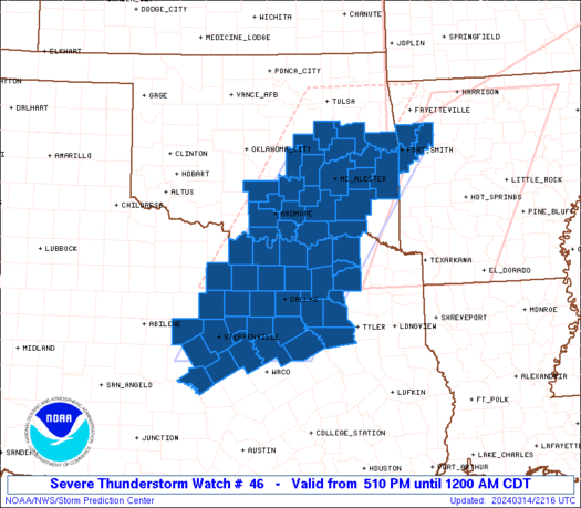
SEL6
URGENT - IMMEDIATE BROADCAST REQUESTED
TORNADO WATCH NUMBER 46
NWS STORM PREDICTION CENTER NORMAN OK
1045 AM EST THU MAR 1 2007
THE NWS STORM PREDICTION CENTER HAS ISSUED A
TORNADO WATCH FOR PORTIONS OF
MUCH OF EASTERN ALABAMA
FLORIDA PANHANDLE
MUCH OF GEORGIA
PARTS OF WESTERN SOUTH CAROLINA
COASTAL WATERS
EFFECTIVE THIS THURSDAY MORNING AND EVENING FROM 1045 AM UNTIL
900 PM EST.
...THIS IS A PARTICULARLY DANGEROUS SITUATION...
DESTRUCTIVE TORNADOES...LARGE HAIL TO 2 INCHES IN DIAMETER...
THUNDERSTORM WIND GUSTS TO 80 MPH...AND DANGEROUS LIGHTNING ARE
POSSIBLE IN THESE AREAS.
THE TORNADO WATCH AREA IS APPROXIMATELY ALONG AND 110 STATUTE
MILES EAST AND WEST OF A LINE FROM 60 MILES NORTHWEST OF ANDERSON
SOUTH CAROLINA TO 35 MILES SOUTH OF PANAMA CITY FLORIDA. FOR A
COMPLETE DEPICTION OF THE WATCH SEE THE ASSOCIATED WATCH OUTLINE
UPDATE (WOUS64 KWNS WOU6).
REMEMBER...A TORNADO WATCH MEANS CONDITIONS ARE FAVORABLE FOR
TORNADOES AND SEVERE THUNDERSTORMS IN AND CLOSE TO THE WATCH
AREA. PERSONS IN THESE AREAS SHOULD BE ON THE LOOKOUT FOR
THREATENING WEATHER CONDITIONS AND LISTEN FOR LATER STATEMENTS
AND POSSIBLE WARNINGS.
OTHER WATCH INFORMATION...CONTINUE...WW 42...WW 43...WW 44...WW
45...
DISCUSSION...AIR MASS EXPECTED TO RAPIDLY DESTABILIZE ACROSS THE
WATCH AREA THRU THE AFTERNOON IN ADVANCE OF THE INTENSE UPPER TROUGH
AND MID/UPPER LEVEL JET. THUNDERSTORMS WILL CONTINUE DEVELOPING
E/NEWD AS AIR MASS DESTABILIZES WITH TORNADIC SUPERCELLS EXPECTED.
POTENTIAL FOR STRONG/VIOLENT TORNADOES DEVELOPING DURING THE
AFTERNOON.
AVIATION...TORNADOES AND A FEW SEVERE THUNDERSTORMS WITH HAIL
SURFACE AND ALOFT TO 2 INCHES. EXTREME TURBULENCE AND SURFACE
WIND GUSTS TO 70 KNOTS. A FEW CUMULONIMBI WITH MAXIMUM TOPS TO
500. MEAN STORM MOTION VECTOR 23050.
...HALES
0 likes
tornado warning for lee, and pontotoc county in northeast ms.
NATIONAL WEATHER SERVICE MEMPHIS TN
1012 AM CST THU MAR 1 2007
MSC081-011630-
/O.CON.KMEG.TO.W.0005.000000T0000Z-070301T1630Z/
LEE MS-
1012 AM CST THU MAR 1 2007
...A TORNADO WARNING REMAINS IN EFFECT UNTIL 1030 AM CST FOR LEE
COUNTY...
AT 1008 AM CST...NATIONAL WEATHER SERVICE DOPPLER RADAR CONTINUED TO
INDICATE A TORNADO. THIS TORNADO WAS LOCATED NEAR TUPELO...MOVING
NORTHEAST AT 50 MPH.
0 likes
There were a few tornado warnings around here (Mobile/Pensacola) this morning. One of the local mets here is terrible! She continually referred to towns and abbreviations by incorrect names (such as "White Forks Road" for the town of Whitehouse Forks, and referring to the abbreviation Ext as an "exit").
When a storm moving through northeast Baldwin County, Alabama crossed the state line into Florida, the tornado warning was extended into that county. But the met here kept showing a storm far south of that and in the next county over as the storm for which the warning was made!
In addition to that, another meteorologist who was operating the computer graphics kept drawing those lines which create projected locations and times for storms -- except that the cone wasn't drawn out nearly far enough. The storm was supposedly, based on the path created, going at a mere 5 mph instead of 40 mph (its actual movement). This led to the on-camera met telling those on "White Forks Road" that the storm would be there in 45 minutes, when in fact they were already in the storm.
0 likes
-
conestogo_flood
- Category 5
- Posts: 1268
- Joined: Wed Sep 28, 2005 5:49 pm
EDIT: I want to clarify my above description a little bit by giving an example. It was around 9:30, and the cone drawn by the person operating the computer said it would be near Whitehouse Forks at 10:16. The on-camera met simply looked at the time and said that it would be there at that time, but it was pretty clear from the radar being shown that the town was getting the brunt of it already. So it wasn't really gross negligence there, but just forgetting exactly what time it was.
Well, these things happened about 90 minutes ago, and it's starting to get better (no tornado warnings now). They aren't breaking in as much into regularly scheduled programming -- and when they are, their other met is starting to get some airtime as well.
conestogo_flood wrote:Call them right now. That is life threatning.
Well, these things happened about 90 minutes ago, and it's starting to get better (no tornado warnings now). They aren't breaking in as much into regularly scheduled programming -- and when they are, their other met is starting to get some airtime as well.
0 likes

Not a good time for server problems on NWS. It may just be crh. Problem is in Kansas City, and they are working on it per espotter msg.
Take care out there everyone. This system is encompassing much of the eastern half of the country. MD 236 indicates new WW may be issued to include all the way up to northern IL & IN. That would throw Chicago in the mix. Storms already firing in the dry slot in central IL.
The upper level dynamics are incredible!
0 likes
-
Brent
- S2K Supporter
- Posts: 38757
- Age: 37
- Joined: Sun May 16, 2004 10:30 pm
- Location: Tulsa Oklahoma
- Contact:
MESOSCALE DISCUSSION 0238
NWS STORM PREDICTION CENTER NORMAN OK
1139 AM CST THU MAR 01 2007
AREAS AFFECTED...SERN MS...CNTRL AND SRN AL...FL PANHANDLE THROUGH
NRN AND CNTRL GA
CONCERNING...SEVERE THUNDERSTORM WATCH 44...46...
VALID 011739Z - 011945Z
THREAT FOR LONG TRACK STRONG TORNADOES APPEARS TO BE INCREASING AND
WILL PERSIST THROUGH THE AFTERNOON FROM SERN MS THROUGH SRN AND
CNTRL AL...THE FL PANHANDLE AND EVENTUALLY INTO CNTRL AND NRN GA.
NUMEROUS STORMS INCLUDING DISCRETE SUPERCELLS CONTINUE DEVELOPING
WITHIN ZONE OF LOW LEVEL CONFLUENCE AND ISENTROPIC LIFT IN WEAKLY
CAPPED ENVIRONMENT OVER THE CNTRL GULF COAST REGION. STRONGEST
STORMS ARE CURRENTLY FROM SERN MS...SRN AND CNTRL AL INTO THE FL
PANHANDLE AND ARE MOVING NE. THE STRONG SLY LOW LEVEL JET IS
ADVECTING MID TO UPPER 60S DEWPOINTS NWD THROUGH THE WARM
SECTOR...AND THIS WILL CONTRIBUTE TO NWD DESTABILIZATION THIS
AFTERNOON DESPITE WIDESPREAD CLOUD COVER. AN AXIS OF MLCAPE FROM 500
TO 1000 J/KG EXISTS ACROSS PARTS MS INTO AL AND THE FL PANHANDLE.
LARGE LOW LEVEL HODOGRAPHS WITH 0-1 KM STORM RELATIVE HELICITY IN
EXCESS OF 300 M2/S2 PERSISTS OVER A LARGE AREA...AND THIS WILL
MAINTAIN A FAVORABLE ENVIRONMENT FOR TORNADIC SUPERCELLS NEXT
SEVERAL HOURS.
STORMS DEVELOPING OVER NRN GA CURRENTLY APPEAR ELEVATED. THE STRONG
LOW LEVEL JET WILL RESULT IN NWD DESTABILIZATION WITH TIME AS FAR N
AS NRN GA LATER THIS AFTERNOON...AND THIS WILL CONTRIBUTE TO AN
INCREASING TORNADO THREAT AS STORMS BECOME SURFACE BASED.
0 likes
#neversummer
-
Weatherfreak14

- Category 5
- Posts: 1381
- Joined: Sat Sep 24, 2005 3:40 pm
- Location: Beaufort, SC
- Contact:
-
Weatherfreak14
- Category 5
- Posts: 1381
- Joined: Sat Sep 24, 2005 3:40 pm
- Location: Beaufort, SC
- Contact:
Return to “USA & Caribbean Weather”
Who is online
Users browsing this forum: AnnularCane and 75 guests