
Severe weather/outbreak? - April 23-25
Moderator: S2k Moderators
Forum rules

The posts in this forum are NOT official forecast and should not be used as such. They are just the opinion of the poster and may or may not be backed by sound meteorological data. They are NOT endorsed by any professional institution or STORM2K.
-
Ed Mahmoud
Re: Severe weather/outbreak? - April 23-25
TXC253-232200-
/O.CON.KSJT.TO.W.0047.000000T0000Z-080423T2200Z/
JONES TX-
434 PM CDT WED APR 23 2008
...A TORNADO WARNING REMAINS IN EFFECT UNTIL 500 PM CDT FOR SOUTH
CENTRAL JONES COUNTY...
AT 429 PM CDT...TRAINED WEATHER SPOTTERS REPORTED A TORNADO NEAR
NOODLE...MOVING EAST AT 38 MPH. RESIDENTS OF SOUTHERN JONES COUNTY
BETWEEN NOODLE AND HAWLEY SHOULD TAKE COVER NOW!
THE TORNADO WILL BE NEAR...
HODGES BY 440 PM CDT...
HAWLEY BY 445 PM CDT...
A TORNADO WATCH REMAINS IN EFFECT UNTIL 1100 PM CDT WEDNESDAY EVENING
FOR WEST CENTRAL TEXAS.
0 likes

-
Ed Mahmoud
Re: Severe weather/outbreak? - April 23-25
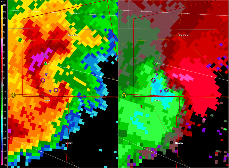
That Jones/Shackleford/Throckmorton cell is a monster, with what looks like a strong circulation near the center, and a weaker circulation on the Southern end.
0 likes
-
Ed Mahmoud
Re: Severe weather/outbreak? - April 23-25
5:01 PM CDT- spotter indicated tornado Northern Jones county, but should stay over rural areas. The best kind of tornado.
0 likes

Re: Severe weather/outbreak? - April 23-25
Ed Mahmoud wrote:That Jones/Shackleford/Throckmorton cell is a monster, with what looks like a strong circulation near the center, and a weaker circulation on the Southern end.
Definately !

0 likes

Re: Severe weather/outbreak? - April 23-25
That is a massive supercell headed toward southern Ft Worth. Hopefully it will slide off more to the SE.
0 likes
But the Albany cell moves towards Breckenridge... 
Here´s the text
* TORNADO WARNING FOR...
STEPHENS COUNTY IN NORTH CENTRAL TEXAS...
* UNTIL 630 PM CDT
* AT 525 PM CDT...A SEVERE THUNDERSTORM WITH A HISTORY OF PRODUCING
TORNADOES WAS 18 MILES WEST OF BRECKENRIDGE..MOVING EAST AT 37 MPH.
* THE TORNADO WILL BE NEAR...
BRECKENRIDGE BY 550 PM CDT...
Here´s the text
* TORNADO WARNING FOR...
STEPHENS COUNTY IN NORTH CENTRAL TEXAS...
* UNTIL 630 PM CDT
* AT 525 PM CDT...A SEVERE THUNDERSTORM WITH A HISTORY OF PRODUCING
TORNADOES WAS 18 MILES WEST OF BRECKENRIDGE..MOVING EAST AT 37 MPH.
* THE TORNADO WILL BE NEAR...
BRECKENRIDGE BY 550 PM CDT...
0 likes
-
TexasStooge

- Category 5

- Posts: 38127
- Joined: Tue Mar 25, 2003 1:22 pm
- Location: Irving (Dallas County), TX
- Contact:
Looks like the immediate DFW area may get hit again with another vicious area of storms.
Just in:
BULLETIN - EAS ACTIVATION REQUESTED
SEVERE THUNDERSTORM WARNING
NATIONAL WEATHER SERVICE FORT WORTH TX
554 PM CDT WED APR 23 2008
THE NATIONAL WEATHER SERVICE IN FORT WORTH HAS ISSUED A
* SEVERE THUNDERSTORM WARNING FOR...
SOUTHERN PALO PINTO COUNTY IN NORTH CENTRAL TEXAS...
* UNTIL 645 PM CDT
* AT 554 PM CDT...NATIONAL WEATHER SERVICE METEOROLOGISTS DETECTED A
SEVERE THUNDERSTORM CAPABLE OF PRODUCING QUARTER SIZE HAIL. THIS
STORM WAS LOCATED 5 MILES SOUTH OF GORDON...AND MOVING NORTH AT 27
MPH.
* THE SEVERE THUNDERSTORM WILL BE NEAR...
GORDON BY 600 PM
MINERAL WELLS BY 640 PM
FOR YOUR PROTECTION MOVE TO A STURDY SHELTER UNTIL THE STORM HAS
PASSED.
IF YOU ARE CAUGHT OUTSIDE...SEEK SHELTER IN A STRONG BUILDING AND
STAY INSIDE...AWAY FROM WINDOWS UNTIL THE STORM HAS PASSED.
A TORNADO WATCH IS IN EFFECT FOR THE WARNING AREA. SEVERE
THUNDERSTORMS CAN PRODUCE TORNADOES WITH LITTLE OR NO WARNING.
LAT...LON 3281 9856 3281 9841 3282 9828 3283 9806
3251 9806 3252 9856
TIME...MOT...LOC 2254Z 175DEG 23KT 3249 9840
0 likes

-
Ed Mahmoud
Re: Severe weather/outbreak? - April 23-25
Doppler showing very strong rotation in Palo Pinto county.
Adjacent Parker and Hood counties just added.
TXC143-363-240015-
/O.CON.KFWD.TO.W.0032.000000T0000Z-080424T0015Z/
PALO PINTO TX-ERATH TX-
650 PM CDT WED APR 23 2008
...A TORNADO WARNING REMAINS IN EFFECT UNTIL 715 PM CDT FOR NORTH
CENTRAL ERATH AND SOUTHEASTERN PALO PINTO COUNTIES...
AT 650 PM CDT...STORM SPOTTERS AND DOPPLER RADAR OBSERVED A
DEVELOPING TORNADO. THIS TORNADO WAS LOCATED OVER EXTREME NORTH
CENTRAL ERATH COUNTY ABOUT 8 MILES WEST OF LIPAN...MOVING EAST AT
23 MPH.
THE TORNADO WILL BE NEAR...
RURAL NORTHERN ERATH COUNTY AT 700 PM CDT
RURAL SOUTHEASTERN PALO PINTO COUNTY AT 700 PM CDT
RURAL NORTHEASTERN ERATH COUNTY AT 710 PM CDT
Adjacent Parker and Hood counties just added.
0 likes
-
Ed Mahmoud
Re: Severe weather/outbreak? - April 23-25
PRELIMINARY LOCAL STORM REPORT
NATIONAL WEATHER SERVICE FORT WORTH TX
705 PM CDT WED APR 23 2008
..TIME.. ...EVENT... ...CITY LOCATION... ...LAT.LON...
..DATE.. ....MAG.... ..COUNTY LOCATION..ST.. ...SOURCE....
..REMARKS..
0702 PM TSTM WND DMG 4 NW MORGAN MILL 32.43N 98.21W
04/23/2008 ERATH TX LAW ENFORCEMENT
SIGNIFICANT STRUCTURAL DAMAGE ON HWY 1188 NE OF MORGAN
MILL. POSSIBLE TORNADO
$$
--------------------------------------------------------------------------------
000
NWUS54 KFWD 232358
LSRFWD
PRELIMINARY LOCAL STORM REPORT
NATIONAL WEATHER SERVICE FORT WORTH TX
657 PM CDT WED APR 23 2008
..TIME.. ...EVENT... ...CITY LOCATION... ...LAT.LON...
..DATE.. ....MAG.... ..COUNTY LOCATION..ST.. ...SOURCE....
..REMARKS..
0656 PM TORNADO 9 NNE MORGAN MILL 32.51N 98.11W
04/23/2008 PALO PINTO TX LAW ENFORCEMENT
TORNADO ON THE GROUND 5 MILES WEST OF LIPAN
$$
--------------------------------------------------------------------------------
0 likes
-
Category 5

- Category 5
- Posts: 10074
- Age: 36
- Joined: Sun Feb 11, 2007 10:00 pm
- Location: New Brunswick, NJ
- Contact:
Re: Severe weather/outbreak? - April 23-25
Damage reported with this cell, this certainly contains a tornado.


0 likes
-
Ed Mahmoud
Re:
Bunkertor wrote:Unfortunately i can´t copy the message, but a cell, called a7, carries 4 inch ! hail ! Means 10 cm in diameter and that´s exactly softball-size
My AccuWx PPV radar has that as the cell in Southern Parker county, SW of Fort Worth, with a VIL of 75 Kg/m2, which is a big VIL. From what I've read, one needs a certain amount of local knowledge to correlate exactly a VIL to a hail size, but 75 is big.
That 75 is down from a max of 80.
0 likes
-
Category 5
- Category 5
- Posts: 10074
- Age: 36
- Joined: Sun Feb 11, 2007 10:00 pm
- Location: New Brunswick, NJ
- Contact:
Re: Severe weather/outbreak? - April 23-25
I don't know what it's doing now. Looks almost cyclonic.
0 likes
Re: Re:
Ed Mahmoud wrote:Bunkertor wrote:Unfortunately i can´t copy the message, but a cell, called a7, carries 4 inch ! hail ! Means 10 cm in diameter and that´s exactly softball-size
My AccuWx PPV radar has that as the cell in Southern Parker county, SW of Fort Worth, with a VIL of 75 Kg/m2, which is a big VIL. From what I've read, one needs a certain amount of local knowledge to correlate exactly a VIL to a hail size, but 75 is big.
That 75 is down from a max of 80.
True. You meant cubic meters m^3 ? and 75 kg is definately very much. I can´t really imagine.
0 likes
-
Ed Mahmoud
Re: Re:
Bunkertor wrote:Ed Mahmoud wrote:Bunkertor wrote:Unfortunately i can´t copy the message, but a cell, called a7, carries 4 inch ! hail ! Means 10 cm in diameter and that´s exactly softball-size
My AccuWx PPV radar has that as the cell in Southern Parker county, SW of Fort Worth, with a VIL of 75 Kg/m2, which is a big VIL. From what I've read, one needs a certain amount of local knowledge to correlate exactly a VIL to a hail size, but 75 is big.
That 75 is down from a max of 80.
True. You meant cubic meters m^3 ? and 75 kg is definately very much. I can´t really imagine.
Pretty sure I meant square meters. VIL is the apparent weight of water in a column of atmosphere, surface to way high, one meter square in area.
METEOROLOGIST JEFF HABY
VIL was a "fad" and was most popular when the WSR-88D radar was first installed. VIL is the integration of reflectivity within a column of air. A higher VIL means there is more precipitation in a column of air. At one time it was thought a VIL value is associated with a certain hail size. The term "VIL of the day" was a term used by the NWS to describe the VIL value that associates with severe hail (3/4" of an inch in diameter or greater). If was found that the relationship between the VIL value and hail size is much more complex than previously thought. The VIL values correlation to hail size depends on season, synoptic environment, elevation, storm speed, storm structure, hail reflectivity characteristics etc. The relationship is too complex to issue a severe thunderstorm warning with respect to hail size from the VIL value alone, although the VIL value can be used as a guide and is especially useful if the VIL is very high. The VIL value has the following limitations:
1. The values are seasonally and regionally dependent. The value is also dependent upon the cloud physics and synoptic considerations for that particular day.
2. Values within 20 miles of radar will be underestimated since part of the storm will be in the radar's cone of silence. Values at the edge of the radar display are also underestimated since the higher elevation angles are overshooting the storms (lower half of storm is not being sampled). VIL values will be higher where all tilt angles are able to sample the entire precipitation / hail core of the storm.
3. VILs are less accurate for highly tilted storms. VIL is underestimated for tilted updrafts since the hail core tilts with respect to a vertical column of reflectivity.
4. VILs are higher for wet hail than dry hail
5. VIL value may be contaminated by non-precipitation echoes
VIL can be used as a "guide" for assessing hail size and intensity of precipitation but as mentioned has many limitations. VIL has units of mass divided by area (kg/m^2). The mass is estimated by the radar reflectivity factor. VIL has a display similar to reflectivity products: heavier precipitation and hail will show a higher VIL (higher VIL value colors).
Last edited by Ed Mahmoud on Wed Apr 23, 2008 8:20 pm, edited 1 time in total.
0 likes
Return to “USA & Caribbean Weather”
Who is online
Users browsing this forum: Stratton23 and 112 guests