Severe weather outbreak? March 23-24 - Plains/Midwest
Moderator: S2k Moderators
Forum rules

The posts in this forum are NOT official forecast and should not be used as such. They are just the opinion of the poster and may or may not be backed by sound meteorological data. They are NOT endorsed by any professional institution or STORM2K.

-
keithy joe

- Tropical Low

- Posts: 22
- Age: 43
- Joined: Wed Sep 10, 2008 11:46 am
- Location: England - UK (Plymouth)
- Contact:
Re: Severe weather outbreak? March 23-24 - Plains/Midwest
An interesting synoptic situation arising during the course of Monday. The main triple point of airmass collision generating the highest SREH and wind-shear environment along with the highest DP is currently forecast to be the Ponca City, Arkansas City and Wichita areas of N OK and the South of Kansas.
0 likes
-
srainhoutx

- S2K Supporter

- Posts: 6919
- Age: 68
- Joined: Sun Jan 14, 2007 11:34 am
- Location: Haywood County, NC
- Contact:
Re: Severe weather outbreak? March 23-24 - Plains/Midwest
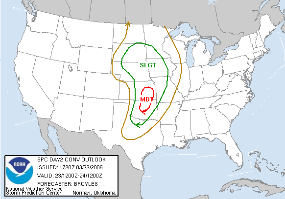
DAY 2 CONVECTIVE OUTLOOK
NWS STORM PREDICTION CENTER NORMAN OK
1228 PM CDT SUN MAR 22 2009
VALID 231200Z - 241200Z
...THERE IS A MDT RISK OF SVR TSTMS ACROSS PARTS OF ERN KS...NRN
OK...CNTRL OK...
...THERE IS A SLGT RISK OF SVR TSTMS ACROSS PARTS OF THE GREAT
PLAINS AND UPPER MIDWEST...
...NEBRASKA AND SOUTH DAKOTA...
A WELL-DEVELOPED UPPER-LEVEL TROUGH OVER THE FOUR CORNERS REGION
WILL CLOSE-OFF TONIGHT ACROSS COLORADO AND MOVE QUICKLY ENEWD INTO
CNTRL HIGH PLAINS MONDAY. AHEAD OF THE SYSTEM...A BROAD 50 TO 65 KT
LOW-LEVEL JET WILL BE IN PLACE FROM THE SRN PLAINS EXTENDING NWD
INTO THE MID-MO RIVER VALLEY. ELEVATED WARM ADVECTION THUNDERSTORMS
WITH SOME MARGINALLY SEVERE HAIL SHOULD BE ONGOING AT THE BEGINNING
OF THE PERIOD FROM WRN IA AND ERN NEB SSWWD ACROSS ERN KS INTO NRN
OK. AS THE UPPER-LEVEL SYSTEM APPROACHES THE GREAT PLAINS...A
POWERFUL 80 TO 100 KT MID-LEVEL JET WILL ROUND THE BASE OF THE
TROUGH AND EJECT NEWD INTO THE CNTRL PLAINS. THE LEFT EXIT REGION OF
THE JET ALONG WITH A PLUME OF STEEP MID-LEVEL LAPSE RATES IS
FORECAST TO SPREAD ACROSS NEBRASKA EARLY IN THE PERIOD. IN
RESPONSE...THE MODELS ARE IN GOOD AGREEMENT...DEVELOPING A
CONCENTRATED CLUSTER OF THUNDERSTORMS ACROSS WRN SD AND NW NEB
MONDAY MORNING. THIS ACTIVITY SHOULD SPREAD ENEWD INTO ERN SD BY
EARLY AFTERNOON EXPANDING SWD WITH TIME ACROSS NCNTRL AND ERN NEB.
AHEAD OF THE UPPER-LEVEL LOW...LARGE-SCALE ASCENT WILL BE QUITE
STRONG ACROSS THE WRN HALF OF NEB INTO SRN SD MONDAY MORNING.
FORECAST SOUNDINGS IN THIS AREA AT 15Z MONDAY SHOW STRONG VERTICAL
SHEAR /0-6 KM SHEAR OF 50-60 KT/ AND 850 TO 500 MB LAPSE RATES
AROUND 8.0 C/KM. THIS ALONG WITH THE STRONG LARGE-SCALE ASCENT
SHOULD BE SUPPORTIVE OF ISOLATED SUPERCELLS WITH HAIL. AS THE
COMPLEX MOVES NEWD INTO ERN SD AND DEVELOPS SWD ACROSS ERN NEB
MONDAY AFTERNOON...LARGE HAIL AND DAMAGING WINDS WILL BE POSSIBLE. A
FEW TORNADOES WILL ALSO BE POSSIBLE ESPECIALLY IF THE CONVECTION CAN
REMAIN DISCRETE.
...OKLAHOMA/KANSAS/NORTH TEXAS...
A WELL-DEVELOPED UPPER-LEVEL TROUGH OVER THE DESERT SOUTHWEST SUNDAY
NIGHT WILL MOVE INTO THE SRN ROCKIES MONDAY WITH SOUTHWEST FLOW IN
PLACE ACROSS THE SRN AND CNTRL PLAINS. AN IMPRESSIVE 80 TO 100 KT
MID-LEVEL JET WILL EJECT ENEWD ACROSS THE CNTRL PLAINS. SOUTH OF THE
AXIS OF THE JET...CONVECTION SHOULD NOT INITIATE THROUGH MUCH OF
MONDAY AFTERNOON DUE TO A CAPPING INVERSION. MODEL FORECASTS ARE IN
GOOD AGREEMENT WEAKENING THE CAP AND RAPIDLY INITIATING STORMS
BETWEEN 21Z AND 00Z ALONG THE INTERSTATE-35 CORRIDOR IN ERN KS WITH
THE CONVECTION DEVELOPING SSWWD INTO NRN AND CNTRL OK DURING THE
EARLY EVENING. DUE TO THE STRENGTH OF THE UPPER-LEVEL TROUGH AND
POSITION OF THE INSTABILITY AXIS...THERE IS SUBSTANTIAL CERTAINTY
THAT A LARGE AMOUNT OF THUNDERSTORMS WILL DEVELOP FROM NNE TO SSW
ACROSS THE REGION DURING THE EARLY TO MID-EVENING.
AS THE MID-LEVEL JET EJECTS ENEWD ACROSS THE CNTRL PLAINS...VERTICAL
SHEAR PROFILES WILL STRENGTHEN ACROSS THE SRN AND CNTRL PLAINS. BY
00Z TUESDAY...FORECAST SOUNDINGS SHOW 0-6 KM SHEAR VALUES RANGING
FROM AROUND 50 KT IN NCNTRL KS TO ABOUT 75 KT IN SRN OK. IN
ADDITION...MID-LEVEL LAPSE RATES WILL BE QUITE STEEP ALONG THE
INSTABILITY AXIS. THIS COMBINED WITH THE STRONG VERTICAL SHEAR
SHOULD BE FAVORABLE FOR SUPERCELLS WITH LARGE HAIL. THE MOST INTENSE
STORMS COULD PRODUCE VERY LARGE HAIL FROM SE KS SSWWD ACROSS WCNTRL
OK WITH ISOLATED LARGE HAIL ALSO POSSIBLE IN NORTH TX. IN
ADDITION...FORECAST SOUNDINGS BY EARLY EVENING ACROSS CNTRL OK AND
SRN KS SHOW 0-1 KM SHEAR VALUES IN THE 30 TO 40 KT RANGE SUGGESTING
TORNADOES WILL BE POSSIBLE WITH THE MORE ORGANIZED STORMS. A FEW
STRONG TORNADOES WILL BE POSSIBLE ALONG THE INTERSTATE-35 CORRIDOR
ESPECIALLY IF SUPERCELLS CAN REMAIN DISCRETE THROUGH THE EARLY
EVENING. IF A SQUALL-LINE RAPIDLY DEVELOPS BY EARLY EVENING...THEN
THE DOMINATE SEVERE THREATS WOULD LIKELY BE HAIL AND WIND DAMAGE.
ALTHOUGH UNCERTAINTY STILL EXISTS CONCERNING STORM MODE...THE
POTENTIAL FOR A CONCENTRATED AREA FOR SEVERE CONVECTION WARRANTS A
MODERATE RISK FROM ERN KS SSWWD ACROSS NRN AND CNTRL OK.
..BROYLES.. 03/22/2009
CLICK TO GET WUUS02 PTSDY2 PRODUCT
0 likes
-
6SpeedTA95
- Category 5

- Posts: 1206
- Joined: Wed Oct 19, 2005 3:25 pm
- Location: Oklahoma
- Contact:
this is shaping up to be pretty interesting...
I think right now everything hinges on moisture return. The forcast dewpoints are in the mid/upper 50s for the OKC/Tulsa area which isn't bad and would be enough fuel to spark supercell storms and a few tornadoes. If dewpoints make it into the low 60s we may see an upgrade to high risk. Given the strong forcing and great lapse rates the real limiting factor in my opinion will be moisture.
Right now shreveport has dewpoints in the upper 50's, that moisture will be moving to the north and west, and there'sa 10* spread between shreveport and texarkana right now. We'll see how the moisture advances the next 30 hours.
0 likes
-
srainhoutx
- S2K Supporter
- Posts: 6919
- Age: 68
- Joined: Sun Jan 14, 2007 11:34 am
- Location: Haywood County, NC
- Contact:
Re: Severe weather outbreak? March 23-24 - Plains/Midwest
As the days have unfolded and poor model guidance for the past couple of weeks, it does look as if things will get active Monday and also with the next system entering the picture off the NW PAC. The second system looks to offer a bigger threat for a much larger area in my humble opinion later this week.
0 likes
-
6SpeedTA95
- Category 5
- Posts: 1206
- Joined: Wed Oct 19, 2005 3:25 pm
- Location: Oklahoma
- Contact:
-
6SpeedTA95
- Category 5
- Posts: 1206
- Joined: Wed Oct 19, 2005 3:25 pm
- Location: Oklahoma
- Contact:
Re: Severe weather outbreak? March 23-24 - Plains/Midwest
srainhoutx wrote:As the days have unfolded and poor model guidance for the past couple of weeks, it does look as if things will get active Monday and also with the next system entering the picture off the NW PAC. The second system looks to offer a bigger threat for a much larger area in my humble opinion later this week.
Yeah i was just checking that out, looks like a friday/sat/sun type of time frame for the great plains on that one.
0 likes

-
6SpeedTA95
- Category 5
- Posts: 1206
- Joined: Wed Oct 19, 2005 3:25 pm
- Location: Oklahoma
- Contact:
Re:
RL3AO wrote:GFS showing dewpoints a tad higher than the NAM.
At Tulsa tomorrow, the GFS has the dewpoint at 56 while the NAM has it at 52.
Yeah and that will make a big difference...
I would expect some tightening tonight as moisture return can be monitored throughout the day to areas south and east of the moderate box.
0 likes
-
6SpeedTA95
- Category 5
- Posts: 1206
- Joined: Wed Oct 19, 2005 3:25 pm
- Location: Oklahoma
- Contact:
-
CrazyC83
- Professional-Met

- Posts: 34315
- Joined: Tue Mar 07, 2006 11:57 pm
- Location: Deep South, for the first time!
Re: Severe weather outbreak? March 23-24 - Plains/Midwest
Most recent run has the following synoptics: (red - more conducive for severe weather than the previous estimate, green - less conducive)
EHI - Peaks over 3.50 in Oklahoma.
CAPE - Generally around 1,000 with an isolated peak near 1,750 in Kansas.
Dewpoints - Upper 50s with a tongue of lower 60s in Oklahoma and Kansas.
LI - Peaks around -6 on the dryline.
Helicity - Mostly running in the 500-750 range.
It definitely looks like a possible I-35 corridor event.
0 likes
-
6SpeedTA95
- Category 5
- Posts: 1206
- Joined: Wed Oct 19, 2005 3:25 pm
- Location: Oklahoma
- Contact:
Re: Severe weather outbreak? March 23-24 - Plains/Midwest
CrazyC83 wrote:Most recent run has the following synoptics: (red - more conducive for severe weather than the previous estimate, green - less conducive)
EHI - Peaks over 3.50 in Oklahoma.
CAPE - Generally around 1,000 with an isolated peak near 1,750 in Kansas.
Dewpoints - Upper 50s with a tongue of lower 60s in Oklahoma and Kansas.
LI - Peaks around -6 on the dryline.
Helicity - Mostly running in the 500-750 range.
It definitely looks like a possible I-35 corridor event.
Things should fire over I35 or just to the west and move north east as the evening progresses...
What is EHI and do you have a link so I can read about it? I guess I'm not familiar with that parameter which is surprising...
0 likes
Re: Severe weather outbreak? March 23-24 - Plains/Midwest
6SpeedTA95 wrote:Things should fire over I35 or just to the west and move north east as the evening progresses...
What is EHI and do you have a link so I can read about it? I guess I'm not familiar with that parameter which is surprising...
http://www.theweatherprediction.com/habyhints/314/
Basically its cape x helicity/160,000
0 likes
-
6SpeedTA95
- Category 5
- Posts: 1206
- Joined: Wed Oct 19, 2005 3:25 pm
- Location: Oklahoma
- Contact:
Re: Severe weather outbreak? March 23-24 - Plains/Midwest
RL3AO wrote:6SpeedTA95 wrote:Things should fire over I35 or just to the west and move north east as the evening progresses...
What is EHI and do you have a link so I can read about it? I guess I'm not familiar with that parameter which is surprising...
http://www.theweatherprediction.com/habyhints/314/
Basically its cape x helicity/160,000
Fantastic! Thank you sir...you'd think i would have known that as much/as long as I've been following weather, learn something new every day
0 likes
-
Ed Mahmoud
Re: Severe weather outbreak? March 23-24 - Plains/Midwest
Double Post alert:
Storms just West of I-35 with MUCAPE over 1000 OK into KS

Spooky forecast sounding for EWG land

**Discovered I was on wrong severe thread...***
AREA FORECAST DISCUSSION
NATIONAL WEATHER SERVICE WICHITA KS
319 PM CDT SUN MAR 22 2009
...
TRAILING DRYLINE ASSOCIATED WITH THIS STORM SYSTEM...PUSHES TO
AROUND INTERSTATE 135 BY THE AFTERNOON HOURS...AS WEAK CAPPING
INVERSION DIMINISHES. MON AFTERNOON/EVENING STILL LOOKS LIKE A
SEVERE WEATHER EVENT AS UPPER LEVEL JET STREAK HELPS DESTABILIZE
THINGS ACROSS THE AREA. ONLY EXPECT SURFACE DEWPOINTS IN THE
MID-UPPER 50S...SO STILL LOOK LIKES A MARGINAL INSTABILITY (CAPES OF
750-1500 J/KG) HIGH SHEAR SETUP WITH 0-6KM SHEAR VALUES OR 55-70 KTS
ACROSS PORTIONS OF CENTRAL AND SOUTH CENTRAL KS. AS COLD FRONT
OVERTAKES THE DRY LINE NEAR INTERSTATE 35 AROUND 00Z/TUE...0-1KM
SHEAR ALSO LOOKS TO INCREASE TO AROUND 30 KTS...WHICH WILL INCREASE
THE THREAT OF DISCRETE SUPERCELLS ACROSS SOUTHERN KS. SO LARGE HAIL
AND DAMAGING WIND GUSTS WILL CERTAINLY BE POSSIBLE...BUT ALSO CANNOT
RULE OUT A TORNADO THREAT ACROSS SOUTHERN KS CLOSER TO THE KS/OK
BORDER WHERE BACKING LOW LEVEL WINDS WILL INCREASE THE DIRECTIONAL
SHEAR.
CONVECTION WILL GRADUALLY TRANSITION INTO A SQUALL LINE OR LINEAR
MCS OVERNIGHT MONDAY AS DEEP LAYER SHEAR BECOMES MORE UNIDIRECTIONAL
AS COLD FRONTAL BOUNDARY PUSHES INTO EASTERN KS BY EARLY ON TUE.
AREA FORECAST DISCUSSION
NATIONAL WEATHER SERVICE TULSA OK
321 PM CDT SUN MAR 22 2009
.....
STRONG UPPER TROUGH...CURRENTLY MOVING THROUGH THE DESERT SOUTHWEST
WILL SHIFT INTO THE SOUTHERN PLAINS ON MONDAY WITH SEVERE WEATHER
LIKELY MONDAY EVENING INTO THE OVERNIGHT HOURS. GUSTY SOUTH WINDS
MAY BEGIN TO APPROACH 40 MPH MONDAY AFTERNOON ACROSS PORTIONS OF
NORTHEAST OKLAHOMA...THEREFORE A WIND ADVISORY MAY BE NEEDED AS
FORECAST BECOMES MORE CERTAIN. IMPRESSIVE UPPER LEVEL JET STREAK
AT 300 MB WILL SWING AROUND BASE OF TROUGH WITH 110 KNOT JET AXIS
SPREADING ACROSS WESTERN OKLAHOMA DURING THE AFTERNOON. SCATTERED
THUNDERSTORMS WILL LIKELY INITIATE ALONG DRY LINE/PACIFIC FRONT BY
LATE AFTERNOON ACROSS CENTRAL OKLAHOMA WITH THE POTENTIAL FOR A FEW
ISOLATED STORMS TO MOVE INTO PORTIONS OF NORTHEAST OKLAHOMA DURING
THE EVENING HOURS. ANY STORMS THAT CAN REMAIN DISCRETE DURING THIS
TIME WOULD HAVE AN ENHANCED TORNADO/SEVERE THREAT...MAINLY
ALONG/NORTH OF INTERSTATE 44.
THE MORE WIDESPREAD SEVERE THREAT WILL LIKELY OCCUR DURING THE
OVERNIGHT HOURS AS COLD FRONT OVERTAKES BOUNDARY FROM THE NORTH.
STRONG TO SEVERE SQUALL LINE WILL LIKELY DEVELOP ALONG
SOUTHEASTWARD MOVING COLD FRONT WITH LINE OF STORMS SWEEPING INTO
NORTHWEST ARKANSAS/FAR SOUTHEAST OKLAHOMA TUESDAY MORNING.
ALTHOUGH ELEVATED INSTABILITY WILL BEGIN TO DECREASE DURING THIS
TIME...IMPRESSIVE LOW LEVEL WIND FIELDS WILL LIKELY KEEP AT LEAST
A LIMITED SEVERE THREAT THROUGH TUESDAY MORNING ACROSS NORTHWEST
ARKANSAS AND FAR SOUTHEAST OKLAHOMA. A LIMITED TORNADO THREAT
COULD ALSO REMAIN MONDAY NIGHT WITH A FEW OF THE STRONGER CELLS
EMBEDDED WITHIN THE MAIN CONVECTIVE LINE.
AREA FORECAST DISCUSSION
NATIONAL WEATHER SERVICE NORMAN OK
255 PM CDT SUN MAR 22 2009
...
SEVERE WEATHER POTENTIAL LOOKING FAIRLY CERTAIN FOR LATE TOMORROW
THROUGH TOMORROW NIGHT. ALTHOUGH QUALITY OF LOWER-LEVEL MOISTURE
AND INSTABILITY NOT ALL THAT IMPRESSIVE...VERY STRONG SHEAR AND
INTENSIFYING MID-UPPER LEVEL DYNAMICS WILL LIKELY LEAD TO
WIDESPREAD SEVERE THUNDERSTORMS. INITIALLY...SAY LATE AFTERNOON
THROUGH A FEW HOURS INTO THE EVENING...DEEP LAYER SHEAR WILL FAVOR
DISCRETE THUNDERSTORM MODES...BUT QUICKLY EVOLVE INTO LINEAR MODE
AS STRONGER FORCING APPROACHES AND DEEP LAYER WINDS BACK. STORM
COMPLEX EXPECTED TO SHIFT EAST AND SOUTHEAST OVER CENTRAL AND
SOUTHEAST PORTIONS OF THE FORECAST AREA OVERNIGHT AND EARLY
TUESDAY MORNING.
Storms just West of I-35 with MUCAPE over 1000 OK into KS
Spooky forecast sounding for EWG land
**Discovered I was on wrong severe thread...***
0 likes
-
6SpeedTA95
- Category 5
- Posts: 1206
- Joined: Wed Oct 19, 2005 3:25 pm
- Location: Oklahoma
- Contact:
Re: Severe weather outbreak? March 23-24 - Plains/Midwest
Ed Mahmoud wrote:Spooky forecast sounding for EWG land
**Discovered I was on wrong severe thread...***
The model soundings for 6pm for tulsa and OKC are kinda scary, if moisture is above 58* we could have an outbreak...I think we'll see a couple tornadoes regardless
0 likes
-
6SpeedTA95
- Category 5
- Posts: 1206
- Joined: Wed Oct 19, 2005 3:25 pm
- Location: Oklahoma
- Contact:
Return to “USA & Caribbean Weather”
Who is online
Users browsing this forum: SnowyOwl31 and 98 guests