
Historic outbreak Sunday: The aftermath
Moderator: S2k Moderators
Forum rules

The posts in this forum are NOT official forecast and should not be used as such. They are just the opinion of the poster and may or may not be backed by sound meteorological data. They are NOT endorsed by any professional institution or STORM2K.
-
WaitingForSiren

- Category 1

- Posts: 383
- Joined: Sun Jan 08, 2006 12:58 pm
- Location: Minneapolis,Minnesota
- Contact:
That area definitely seems reasonable. Especially for thursday. I will make another graphic later today. But right now, looks like a big outbreak on thursday around the area you indicated and me as well, then on friday another outbreak but maybe a little further west as this time the low will be further west according to the latest gfs, but either way the same area could see severe weather two days in a row. Also, it appears a major snowstorm is likely across the northern plains into MN with these storms if the 06Z gfs is right.
0 likes
-
TexasStooge

- Category 5

- Posts: 38127
- Joined: Tue Mar 25, 2003 1:22 pm
- Location: Irving (Dallas County), TX
- Contact:
-
WaitingForSiren
- Category 1
- Posts: 383
- Joined: Sun Jan 08, 2006 12:58 pm
- Location: Minneapolis,Minnesota
- Contact:

-
jhamps10
The following post is NOT an official forecast and should not be used as such. It is just the opinion of the poster and may or may not be backed by sound meteorological data. It is NOT endorsed by any professional institution including storm2k.org For Official Information please refer to the SPC and NWS products.

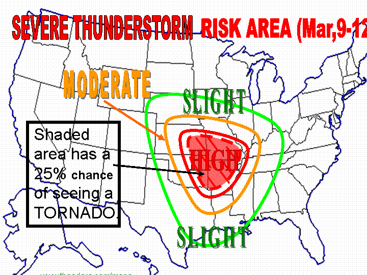
This is my map for the entire time that severe weather is possible. This map could easily change though.
Edited to add Disclaimer.
This is my map for the entire time that severe weather is possible. This map could easily change though.
Edited to add Disclaimer.
Last edited by jhamps10 on Sat Mar 04, 2006 11:24 pm, edited 1 time in total.
0 likes
-
jhamps10
This from St. Louis HWO:
...POTENTIAL FOR SEVERE THUNDERSTORMS THIS UPCOMING WEEK...
A SERIES OF STORM SYSTEMS WILL INTERACT WITH AN INCREASINGLY
UNSTABLE ATMOSPHERE THIS WEEK. GIVEN THE FAVORABLE WIND PROFILE
THAT IS FORECAST TO EXIST ACROSS MISSOURI AND ILLINOIS...THE
POTENTIAL WILL EXIST FOR SEVERAL ROUNDS OF SEVERE WEATHER THIS
UPCOMING WORK WEEK. AT THIS TIME TWO PERIODS APPEAR TO HOLD THE
BEST POTENTIAL FOR SEVERE THUNDERSTORM DEVELOPMENT...ALTHOUGH
THUNDERSTORMS ARE IN THE FORECAST FROM TUESDAY NIGHT THROUGH
FRIDAY NIGHT. THE FIRST IS ON TUESDAY NIGHT AS A WARM FRONT LIFTS
NORTH ACROSS THE REGION AND THE SECOND IS THURSDAY AND THURSDAY
NIGHT AS LOW PRESSURE MOVES ACROSS MISSOURI AND ILLINOIS.
0 likes
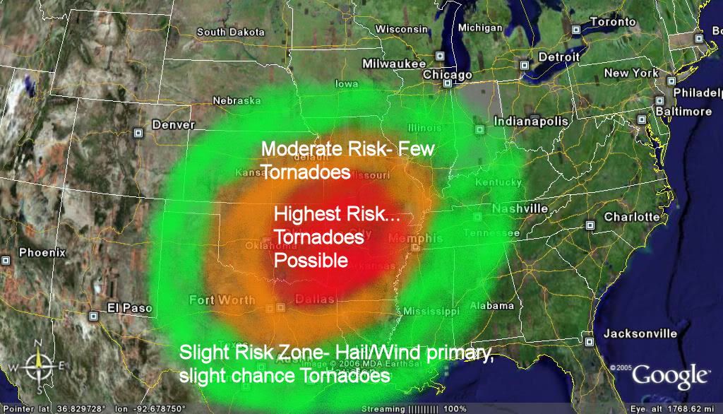
Here is a VERY Early map for Thursday ONLY. Nice to see general agreement with others who have made a map. Lots of change is very possible with this.

EDIT...18z GFS is a good bit weaker and further south than 12z. It would imply a southward shift and also lessening somewhat of the severe threat. Will of course await the 00z GFS (and the other models) before considering any changes to my current thinking.

EDIT...18z GFS is a good bit weaker and further south than 12z. It would imply a southward shift and also lessening somewhat of the severe threat. Will of course await the 00z GFS (and the other models) before considering any changes to my current thinking.
0 likes
-
Hoosierwxdude
- Tropical Depression

- Posts: 61
- Joined: Tue Sep 16, 2003 12:49 pm
- Location: Lafayette, IN
jkt21787 wrote:Here is a VERY Early map for Thursday ONLY. Nice to see general agreement with others who have made a map. Lots of change is very possible with this.
EDIT...18z GFS is a good bit weaker and further south than 12z. It would imply a southward shift and also lessening somewhat of the severe threat. Will of course await the 00z GFS (and the other models) before considering any changes to my current thinking.
Do I know you from somewhere?
Lots of maps already. I might make one eventually.
NWS Lincoln, IL seemed to be contemplating putting severe wording in their zone forecasts, which I find astounding, considering that you basically never see that until a day before an event.
This is my first visit to this board in a while. I will check back from time to time as this event unfolds.
0 likes
-
jhamps10
-
therock1811

- Category 5
- Posts: 5163
- Age: 40
- Joined: Thu May 15, 2003 2:15 pm
- Location: Kentucky
- Contact:
Before I put up my map I need to put up a disclaimer, which is as follows:
The following post is NOT an official forecast and should not be used as such. It is just the opinion of the poster and may or may not be backed by sound meteorological data. It is NOT endorsed by any professional institution including storm2k.org. For official information please refer to the NHC and NWS products.
Now, here it is:
0 likes
-
conestogo_flood
- Category 5
- Posts: 1268
- Joined: Wed Sep 28, 2005 5:49 pm
-
wxmann_91

- Category 5
- Posts: 8007
- Age: 34
- Joined: Fri Jul 15, 2005 2:49 pm
- Location: Southern California
- Contact:
Don't know yet but the models are trending toward less severe attm, weaker sfc low and more unidirectional wind profiles, as well as less agressive moisture return. Of course, much remains to be seen as models frequently flip-flop, I tend to trust 0Z runs the most, which should be coming in about an hour.
0 likes
wxmann_91 wrote:Don't know yet but the models are trending toward less severe attm, weaker sfc low and more unidirectional wind profiles, as well as less agressive moisture return. Of course, much remains to be seen as models frequently flip-flop, I tend to trust 0Z runs the most, which should be coming in about an hour.
Well the 12z GFS was about as classic as it could get for this area. 18z GFS was weaker but still a severe producer of some sort. I never trust 18z runs in general however. Will definitely see what 00z says tonight as said above, usually its the best.
0 likes
-
jhamps10


-
jhamps10
-
jhamps10
-
Extremeweatherguy

- Category 5
- Posts: 11095
- Joined: Mon Oct 10, 2005 8:13 pm
- Location: Florida
Latest 00Z model run has the low further southward and it looks like Thursday afternoon could feature a significant eastern TX severe outbreak! 
http://www.nco.ncep.noaa.gov/pmb/nwprod ... _114.shtml
http://www.nco.ncep.noaa.gov/pmb/nwprod ... _114.shtml
0 likes
-
jhamps10
All areas in particularly MS, AL, TN, KY, but also in portions of TX, LA, AR, MO, and GA, possibly IL and IN too, need to be on guard now. The first group of states now appears at most risk for a significant event based on latest data, and I see nothing unfortunately to lessen the severe threat in those areas at all at this time. No reason to change the title of this thread yet. 
0 likes
Return to “USA & Caribbean Weather”
Who is online
Users browsing this forum: AnnularCane, Brent, South Texas Storms, tolakram and 77 guests