SE TX/SW LA weather: Much cooler and WET after Tuesday
Moderator: S2k Moderators
Forum rules

The posts in this forum are NOT official forecast and should not be used as such. They are just the opinion of the poster and may or may not be backed by sound meteorological data. They are NOT endorsed by any professional institution or STORM2K.

-
srainhoutx

- S2K Supporter

- Posts: 6919
- Age: 68
- Joined: Sun Jan 14, 2007 11:34 am
- Location: Haywood County, NC
- Contact:
Re: SE TX/SW LA weather: Cooler and wet
Looks as if the last in a series of disturbances will move across the area today/tonight and our beneficial rains will come to an end later tonight/tomorrow ending from W to E...
http://adds.aviationweather.noaa.gov/sa ... g&itype=wv
Latest from SPC...
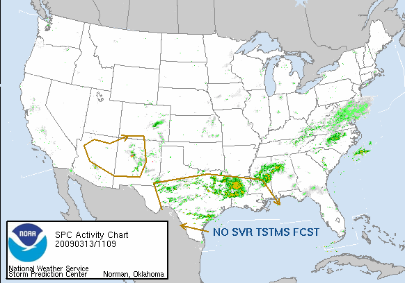
DAY 1 CONVECTIVE OUTLOOK
NWS STORM PREDICTION CENTER NORMAN OK
0747 AM CDT FRI MAR 13 2009
VALID 131300Z - 141200Z
...NO SVR TSTM AREAS FORECAST...
...SYNOPSIS...
A MID LEVEL TROUGH WILL BE MAINTAINED OVER AZ/NM THROUGH THE PERIOD
AS AN EMBEDDED SHORTWAVE TROUGH OVER SRN NM/FAR W TX THIS MORNING
EJECTS ENEWD TO N TX OVERNIGHT. THIS SHORTWAVE TROUGH WILL BE
PRECEDED BY WEAK SURFACE WAVE DEVELOPMENT ALONG THE STALLED FRONT IN
THE NW GULF...AND THIS WAVE IS FORECAST TO PROGRESS NEWD INTO SRN LA
THIS EVENING AND ERN MS/WRN AL BY 14/12Z. A SWATH OF LOW-LEVEL WAA
WILL ALSO DEVELOP EWD FROM SE TX TO THE LOWER MS VALLEY NEAR AND N
OF THE SURFACE WAVE TRACK. MEANWHILE...BOUNDARY LAYER DEWPOINTS IN
THE MID-UPPER 60S WILL SPREAD INLAND ACROSS S CENTRAL/SE LA IN THE
WARM SECTOR. THE INFLUX OF LOW-LEVEL MOISTURE AND WAA WILL SUPPORT
CLUSTERS OF ELEVATED THUNDERSTORMS TODAY FROM CENTRAL/E TX INTO LA.
DESPITE THE PRESENCE OF MID 60S DEWPOINTS...WARM SECTOR INSTABILITY
WILL BE WEAK /MLCAPE AOB 500 J/KG/ AS A RESULT OF POOR MID LEVEL
LAPSE RATES. WARM SECTOR VERTICAL SHEAR WILL ALSO BE RATHER WEAK
UNTIL A MODEST INCREASE IN LOW-LEVEL FLOW OCCURS THIS EVENING INTO
TONIGHT WITH THE INLAND PROGRESSION OF THE SURFACE WAVE. FORECAST
HODOGRAPHS SUGGEST SOME POTENTIAL FOR EMBEDDED STORMS WITH SOME
SUPERCELL CHARACTERISTICS...BUT THE VERY WEAK INSTABILITY AND MODEST
VERTICAL SHEAR DO NOT APPEAR SUPPORTIVE OF ANY APPRECIABLE SEVERE
STORM THREAT.
ELSEWHERE...SCATTERED MAINLY DIURNAL CONVECTION IS EXPECTED FROM THE
MOGOLLON RIM INTO WRN NM...WHERE 7-8 C/KM LAPSE RATES WILL COINCIDE
WITH THE MID LEVEL THERMAL TROUGH.
..THOMPSON/GARNER.. 03/13/2009
Sure helped with the drought situation. My yard and plants are greatful.
http://adds.aviationweather.noaa.gov/sa ... g&itype=wv
Latest from SPC...
DAY 1 CONVECTIVE OUTLOOK
NWS STORM PREDICTION CENTER NORMAN OK
0747 AM CDT FRI MAR 13 2009
VALID 131300Z - 141200Z
...NO SVR TSTM AREAS FORECAST...
...SYNOPSIS...
A MID LEVEL TROUGH WILL BE MAINTAINED OVER AZ/NM THROUGH THE PERIOD
AS AN EMBEDDED SHORTWAVE TROUGH OVER SRN NM/FAR W TX THIS MORNING
EJECTS ENEWD TO N TX OVERNIGHT. THIS SHORTWAVE TROUGH WILL BE
PRECEDED BY WEAK SURFACE WAVE DEVELOPMENT ALONG THE STALLED FRONT IN
THE NW GULF...AND THIS WAVE IS FORECAST TO PROGRESS NEWD INTO SRN LA
THIS EVENING AND ERN MS/WRN AL BY 14/12Z. A SWATH OF LOW-LEVEL WAA
WILL ALSO DEVELOP EWD FROM SE TX TO THE LOWER MS VALLEY NEAR AND N
OF THE SURFACE WAVE TRACK. MEANWHILE...BOUNDARY LAYER DEWPOINTS IN
THE MID-UPPER 60S WILL SPREAD INLAND ACROSS S CENTRAL/SE LA IN THE
WARM SECTOR. THE INFLUX OF LOW-LEVEL MOISTURE AND WAA WILL SUPPORT
CLUSTERS OF ELEVATED THUNDERSTORMS TODAY FROM CENTRAL/E TX INTO LA.
DESPITE THE PRESENCE OF MID 60S DEWPOINTS...WARM SECTOR INSTABILITY
WILL BE WEAK /MLCAPE AOB 500 J/KG/ AS A RESULT OF POOR MID LEVEL
LAPSE RATES. WARM SECTOR VERTICAL SHEAR WILL ALSO BE RATHER WEAK
UNTIL A MODEST INCREASE IN LOW-LEVEL FLOW OCCURS THIS EVENING INTO
TONIGHT WITH THE INLAND PROGRESSION OF THE SURFACE WAVE. FORECAST
HODOGRAPHS SUGGEST SOME POTENTIAL FOR EMBEDDED STORMS WITH SOME
SUPERCELL CHARACTERISTICS...BUT THE VERY WEAK INSTABILITY AND MODEST
VERTICAL SHEAR DO NOT APPEAR SUPPORTIVE OF ANY APPRECIABLE SEVERE
STORM THREAT.
ELSEWHERE...SCATTERED MAINLY DIURNAL CONVECTION IS EXPECTED FROM THE
MOGOLLON RIM INTO WRN NM...WHERE 7-8 C/KM LAPSE RATES WILL COINCIDE
WITH THE MID LEVEL THERMAL TROUGH.
..THOMPSON/GARNER.. 03/13/2009
Sure helped with the drought situation. My yard and plants are greatful.
0 likes
-
vbhoutex

- Storm2k Executive

- Posts: 29149
- Age: 74
- Joined: Wed Oct 09, 2002 11:31 pm
- Location: Cypress, TX
- Contact:
Re: SE TX/SW LA weather: Cooler and wet
1.8" and still 43ºf with drizzle. Looks like more on the way from the SW. I honestly don't remember the last time we had this much rain in 1 day-maybe early December or late November.
0 likes
-
jasons2k

- Storm2k Executive
- Posts: 8290
- Age: 52
- Joined: Wed Jul 06, 2005 12:32 pm
- Location: The Woodlands, TX
Re: SE TX/SW LA weather: Cooler and wet
I had an additional .12" today bringing my total since last night up to 1.07"
Storm total 2.27" so far.
Storm total 2.27" so far.
0 likes
-
vbhoutex
- Storm2k Executive
- Posts: 29149
- Age: 74
- Joined: Wed Oct 09, 2002 11:31 pm
- Location: Cypress, TX
- Contact:
Re: SE TX/SW LA weather: Cooler and wet
And it is 42ºf and starting to drizzle/rain again with a HUGE slug of rain moving in from the SW and it is not going to be offshore like the ocm's thought(not that I listen to them that much). January has returned with a vengeance!!! This is Spring Break week in Texas too!!
Had an additional .30" yesterday so we are up to 2.10" so far. The yard is actually still wet and looks almost like it doesn't need any rain for a while.
Had an additional .30" yesterday so we are up to 2.10" so far. The yard is actually still wet and looks almost like it doesn't need any rain for a while.
0 likes
-
southerngale

- Retired Staff

- Posts: 27418
- Joined: Thu Oct 10, 2002 1:27 am
- Location: Southeast Texas (Beaumont area)
Re: SE TX/SW LA weather: Cooler and wet
vbhoutex wrote:And it is 42ºf and starting to drizzle/rain again with a HUGE slug of rain moving in from the SW and it is not going to be offshore like the ocm's thought(not that I listen to them that much). January has returned with a vengeance!!! This is Spring Break week in Texas too!!
Had an additional .30" yesterday so we are up to 2.10" so far. The yard is actually still wet and looks almost like it doesn't need any rain for a while.
It's like yesterday all over again. Groundhog Day!
0 likes
-
CajunMama
- Retired Staff
- Posts: 10791
- Joined: Thu Feb 06, 2003 9:57 pm
- Location: 30.22N, 92.05W Lafayette, LA
I am chilled to the bone. I've been out in the rain and 50* weather all day. Today was the second annual Mark Graham Foundation Golf Tournament in remembrance of my niece's husband who was injured and subsequently died from his wounds he received in iraq two years ago March 7. Despite the horrible weather the golf tournament was a success. But now i'm sitting here wrapped up in my electric lapblanket.
0 likes
-
jasons2k
- Storm2k Executive
- Posts: 8290
- Age: 52
- Joined: Wed Jul 06, 2005 12:32 pm
- Location: The Woodlands, TX
Re: SE TX/SW LA weather: Cooler and wet
I've had an additional .32" since yesterday morning.
Storm total now 2.59"
I'm excited about this next round.
Storm total now 2.59"
I'm excited about this next round.
0 likes

-
srainhoutx
- S2K Supporter
- Posts: 6919
- Age: 68
- Joined: Sun Jan 14, 2007 11:34 am
- Location: Haywood County, NC
- Contact:
Re: SE TX/SW LA weather: Cooler and wet
AREA FORECAST DISCUSSION
NATIONAL WEATHER SERVICE HOUSTON/GALVESTON TX
956 AM CDT SUN MAR 15 2009
.UPDATE...
SMATTERING OF LIGHT RAIN ACROSS OUR FAR NORTHWESTERN COUNTIES...ALONG
WITH MORE ORGANIZED RAIN AND ISOLATED THUNDERSTORMS MOVING INTO COLORADO
AND WHARTON COUNTIES...THIS MORNING. THIS RETURNING PRECIPITATION ALONG
THE LEADING EDGE OF A SOUTH CENTRAL TEXAS S/W RIDING UP THE EASTERN
PERIPHERY OF A BROAD UPPER LEVEL TROUGH...ITS 5H AXIS CENTERED
ROUGHLY OVER THE NM-TX LINE. RAIN CHANCES WILL INCREASE TO LIKELY
FOR THE SOUTHERN 1/2 OF THE FA TO INCLUDE ALL WATERS. AS THIS
AFOREMENTIONED TROUGH TRAVELS THROUGH NORTHERN TEXAS INTO THE
EVENING...THE HIGHEST AMOUNT OF RAIN WILL GENERALLY FALL ALONG AND
SOUTH OF THE I-10 CORRIDOR...OR ACROSS (NEAR) COASTAL COMMUNITIES.
LATER TODAY...THIS REGION WILL FALL UNDER THE DYNAMICALLY-FAVORED
RRQ OF A NEAR 105KT 200MB JET DRAPED FROM THE TEXAS COAST UP INTO
THE MISSISSIPPI VALLEY. ALTHOUGH SOMEWHAT DIFFICULT TO DISCERN IN
W/V...UPSTREAM VORTICITY ROUNDING THE BEND AND ENTERING THE COASTAL
BEND REGION WITHIN WSW FLOW...IS BEING PROGGED TO ALSO ADD A BIT
MORE LIFT IN THIS SUFFICIENTLY MOIST AIR MASS/ERODE THIS MORNING`S
DEEP 5-6K FT LL INVERSION.
ON AN INTERESTING CLIMATE NOTE: WHAT A DIFFERENCE A YEAR MAKES...THIS
TIME LAST YEAR WE WERE BREAKING MAXIMUM TEMPERATURE RECORDS. MARCH
14 AND 15 OF 2008 YIELDED MAXIMUM RECORDS OF 87 F AND 90 F...RESPECTFULLY
...WITHIN THE CITY (AS WELL AS UP NORTH AT KCLL). NOW...IN THIS COOL
AND WET PATTERN...WE ARE ON THE OTHER SIDE OF THE SPECTRUM...ACHIEVING
RECORD MINIMUM MAXIMUM RECORD TEMPERATURES. A YEAR AGO WE WERE TOPPING
OUT AT 90 F...NOW WE CAN NOT ESCAPE THE GRIP OF THESE CHILLED MID TO
UPPER 40S! 31
0 likes

-
srainhoutx
- S2K Supporter
- Posts: 6919
- Age: 68
- Joined: Sun Jan 14, 2007 11:34 am
- Location: Haywood County, NC
- Contact:
Re:
jasons wrote:
Shot at 2009-03-15
NWUS54 KHGX 151640
LSRHGX
PRELIMINARY LOCAL STORM REPORT
NATIONAL WEATHER SERVICE HOUSTON/GALVESTON TX
1140 AM CDT SUN MAR 15 2009
..TIME... ...EVENT... ...CITY LOCATION... ...LAT.LON...
..DATE... ....MAG.... ..COUNTY LOCATION..ST.. ...SOURCE....
..REMARKS..
1115 AM HAIL 2 SE ADDICKS 29.76N 95.62W
03/15/2009 E0.75 INCH HARRIS TX TRAINED SPOTTER
HAIL REPORTED JUST SOUTH OF INTERSTATE 10 AT VOSS.
0 likes
-
southerngale
- Retired Staff
- Posts: 27418
- Joined: Thu Oct 10, 2002 1:27 am
- Location: Southeast Texas (Beaumont area)
The past several days have been just plain rain here... lots of it but mostly light to moderate.... all. day. long. Today, actual thunderstorms! First time I've had thunder & lightning during this event. I think I've gotten more rain today than the past several days combined.  And every time I think it's ending soon, it keeps redeveloping to the west and continues smacking us. I've got errands to run that I put off until today, thinking the bulk of it would be over... but that's what I get for thinking. I guess I'll be heading out to "play in the rain" soon.

0 likes
-
vbhoutex
- Storm2k Executive
- Posts: 29149
- Age: 74
- Joined: Wed Oct 09, 2002 11:31 pm
- Location: Cypress, TX
- Contact:
Re: SE TX/SW LA weather: Cooler and wet
An additional 0.50" before today's round which puts me at 2.60"(if I'm adding right?). Today's boomers were a surprise as far as the thunder storm aspect of it since we were at 50ºF when it started. Haven't checked the gauge since the rain but we had a downpour to start it off(that hail report is about 3 miles from me-we didn't see any or at least I didn't-will look for evidence though)and then some steady moderate rain for a while. Now we may be looking at 80ºf tomorrow after 4 straight days in the 40's???? 
0 likes


Re: SE TX/SW LA weather: Cooler and wet
vbhoutex wrote:An additional 0.50" before today's round which puts me at 2.60"(if I'm adding right?). Today's boomers were a surprise as far as the thunder storm aspect of it since we were at 50ºF when it started. Haven't checked the gauge since the rain but we had a downpour to start it off(that hail report is about 3 miles from me-we didn't see any or at least I didn't-will look for evidence though)and then some steady moderate rain for a while. Now we may be looking at 80ºf tomorrow after 4 straight days in the 40's????
Talk about a roller coaster ride.
0 likes
-
Ed Mahmoud
Re: SE TX/SW LA weather: Cooler and wet
snips from NWS HGX AFD
AREA FORECAST DISCUSSION
NATIONAL WEATHER SERVICE HOUSTON/GALVESTON TX
307 PM CDT SUN MAR 15 2009
.DISCUSSION...
THE LAST HURRAY FOR THE RAIN...WITH EMBEDDED ISOLATED
THUNDERSTORMS...AS SUBSIDENCE BEHIND THE EASTERN FA SCT SHRA
SHIELD EXITS STAGE RIGHT. LINGERING SHOWERS/ISO STORM ALONG THE
UPPER COAST WILL KEEP CHANCE POPS ONGOING INTO THE SUNSET HOUR.
RAINFALL ACCUMULATIONS AROUND THE CITY OF HOUSTON WERE ANYWHERE
FROM AROUND A FEW TENTHS OF AN INCH TO A HALF OF AN INCH FROM THIS
LATE AM/PM ACTIVITY. MID-LEVEL DRY AIR ENTRAINMENT AND BETTER MID-
LEVEL LAPSE RATE ACHIEVEMENT LEAD TO A COUPLE OF LATE MORNING PULSE
STORMS. THESE ISOLATED CELLS PASSED ACROSS THE METRO AREA AND DROPPED
PEA (TO NEAR PENNY SIZE HAIL) FROM NEAR ADDICKS TO DOWNTOWN...BUT
QUICKLY WEAKENED ON THEIR RAPID NORTHEAST EXIT. FEW CG STROKES
HERE AND THERE FROM ONGOING ACTIVITY TO KEEP MENTION OF ISOLATED
STORMS IN NEAR TERM FORECAST. OVERALL...THE REAL STORY HAS BEEN
THE AMOUNT OF ACCUMULATED RAIN TO ALLEVIATE THIS RECENT EXTREME TO
EXCEPTIONAL DROUGHT. DOPPLER AND BUCKET STP ESTIMATES OF BETWEEN A
HALF AN INCH TO AN INCH AND A HALF MAY BE BETTER THAN NOTHING...ALTHOUGH
FAR FROM TRULY RELIEVING THIS ONGOING DRY SPELL.
AREAS OF EARLY MONDAY MORNING FOG ARE LIKELY TO DEVELOP...POSSIBLY
DENSE IN POCKETS...DUE TO THREE ELEMENTS COMING TOGETHER. THOSE
THREE WOULD BE PARTIALLY CLEARING SKIES...SATURATED GROUND...AND
LIGHTENING WINDS AS HIGH PRESSURE BUILDS BACK IN OVER SE TEXAS.
AFTER REGIONS OF PATCHY FOG BURN OFF BY MID-MORNING...MOSTLY SUNNY
AND WARMER CONDITIONS WILL PREVAIL THROUGH MID WEEK. ACTUALLY...A
VERY PLEASANT AND DRY FORECAST THROUGH THE MAJORITY OF THE WORK
WEEK. TRANSITORY RIDGING WILL BUILD IN THE WAKE OF THIS BROAD
TROUGH`S EXIT. INCREASING THICKNESS VALUES BACK INTO THE LOW-MID 560
DAMS...ALONG WITH RETURNING ONSHORE FLOW BY TOMORROW NIGHT...WILL
AID IN NOT ONLY KEEPING DAILY TEMPERATURES AROUND 5 DEGREES ABOVE
NORMAL...BUT SLOWLY HEIGHTEN HUMIDITIES AS TDS LIFT IN TO THE LOW
TO MID 50S BY WEDNESDAY. THIS INCREASED LL MOISTURE WILL REGULATE
OUR OVERNIGHT MINIMUMS...RIGHT AROUND CLIMO IN THE INTERIOR LOWER
50S TO COASTAL LOWER 60S.
0 likes
-
jasons2k
- Storm2k Executive
- Posts: 8290
- Age: 52
- Joined: Wed Jul 06, 2005 12:32 pm
- Location: The Woodlands, TX
Re: SE TX/SW LA weather: Cooler and wet
Only an additional .24" today, but my storm total was 2.83" so that's not too bad. We sure needed it.
0 likes
-
vbhoutex
- Storm2k Executive
- Posts: 29149
- Age: 74
- Joined: Wed Oct 09, 2002 11:31 pm
- Location: Cypress, TX
- Contact:
Re: SE TX/SW LA weather: Cooler and wet
Another 0.70" today for a total of 3.3" with this system. Looks like the week will be some time to dry out a little. I just hope this isn't the last hurrah for rain for a long time!!! We sure needed it, but is there still a sun? 
0 likes