Probs are 50/40. Tornado threat uncertain, but strong/violent tornadoes cannot be ruled out IF they get going.
SEL3
URGENT - IMMEDIATE BROADCAST REQUESTED
TORNADO WATCH NUMBER 163
NWS STORM PREDICTION CENTER NORMAN OK
835 PM CDT FRI APR 13 2012
THE NWS STORM PREDICTION CENTER HAS ISSUED A
TORNADO WATCH FOR PORTIONS OF
WESTERN AND CENTRAL OKLAHOMA
EFFECTIVE THIS FRIDAY NIGHT AND SATURDAY MORNING FROM 835 PM
UNTIL 400 AM CDT.
TORNADOES...HAIL TO 2.5 INCHES IN DIAMETER...THUNDERSTORM WIND
GUSTS TO 70 MPH...AND DANGEROUS LIGHTNING ARE POSSIBLE IN THESE
AREAS.
THE TORNADO WATCH AREA IS APPROXIMATELY ALONG AND 75 STATUTE
MILES NORTH AND SOUTH OF A LINE FROM 45 MILES WEST NORTHWEST OF
CLINTON OKLAHOMA TO 40 MILES EAST NORTHEAST OF CHANDLER OKLAHOMA.
FOR A COMPLETE DEPICTION OF THE WATCH SEE THE ASSOCIATED WATCH
OUTLINE UPDATE (WOUS64 KWNS WOU3).
REMEMBER...A TORNADO WATCH MEANS CONDITIONS ARE FAVORABLE FOR
TORNADOES AND SEVERE THUNDERSTORMS IN AND CLOSE TO THE WATCH
AREA. PERSONS IN THESE AREAS SHOULD BE ON THE LOOKOUT FOR
THREATENING WEATHER CONDITIONS AND LISTEN FOR LATER STATEMENTS
AND POSSIBLE WARNINGS.
OTHER WATCH INFORMATION...CONTINUE...WW 160...WW 161...WW 162...
DISCUSSION...CLUSTER OF SUPERCELLS WITH A HISTORY OF TORNADOES OVER
SWRN OK /FROM W LTS TO NW FSI/ IS EXPECTED TO TRACK ENEWD ALONG
OUTFLOW BOUNDARY INTO CNTRL OK LATER TONIGHT. CURRENT VAD
OBSERVATIONS FROM FREDRICK OK AND TWIN LAKES OK INDICATE NOTABLE
STRENGTHENING OF THE LLJ OVER THE PAST HOUR WITH 0-1 KM SRH OF
300-400 M2/S2. TORNADO THREAT WILL BE DICTATED BY ABILITY OF STORMS
TO MANAGE CONVECTIVE OUTFLOW...THOUGH SIGNIFICANT TORNADOES ARE
POSSIBLE GIVEN THE STRONG LOW-LEVEL SHEAR. ELSEWHERE...A SECONDARY
CORRIDOR OF TORNADO POTENTIAL WILL EXIST TONIGHT ACROSS PORTIONS OF
NRN OK WHERE LOW-LEVEL SHEAR AND MOISTURE ARE INCREASING WITHIN A
BOUNDARY LAYER THAT WAS NOT OVERTURNED BY EARLIER CONVECTION.
AVIATION...TORNADOES AND A FEW SEVERE THUNDERSTORMS WITH HAIL
SURFACE AND ALOFT TO 2.5 INCHES. EXTREME TURBULENCE AND SURFACE
WIND GUSTS TO 60 KNOTS. A FEW CUMULONIMBI WITH MAXIMUM TOPS TO
500. MEAN STORM MOTION VECTOR 24020.
...MEAD
Plains Tornado Outbreak 4/14-15
Moderator: S2k Moderators
Forum rules

The posts in this forum are NOT official forecast and should not be used as such. They are just the opinion of the poster and may or may not be backed by sound meteorological data. They are NOT endorsed by any professional institution or STORM2K.
-
brunota2003

- S2K Supporter

- Posts: 9476
- Age: 35
- Joined: Sat Jul 30, 2005 9:56 pm
- Location: Stanton, KY...formerly Havelock, NC
- Contact:


SW Oklahoma looks nasty, I hope folks in OKC have their weather radios ready tonight.
0 likes
The above post and any post by Ntxw is NOT an official forecast and should not be used as such. It is just the opinion of the poster and may or may not be backed by sound meteorological data. It is NOT endorsed by any professional institution including Storm2k. For official information, please refer to NWS products.
Help support Storm2K!

-
Dave

- Retired Staff

- Posts: 13442
- Age: 75
- Joined: Tue Aug 01, 2006 3:57 pm
- Location: Milan Indiana
- Contact:
Assistant EMA director for our county posted this on facebook a few hours ago...."SPC will have a fully staffed, fully operational backup office working in tandem at Scott Air Force Base near East St. Louis, IL in the event the Norman, OK main office has to evacuate, or gets hit by a tornado."
0 likes


-
CrazyC83
- Professional-Met

- Posts: 34315
- Joined: Tue Mar 07, 2006 11:57 pm
- Location: Deep South, for the first time!
Re:
Dave wrote:Assistant EMA director for our county posted this on facebook a few hours ago...."SPC will have a fully staffed, fully operational backup office working in tandem at Scott Air Force Base near East St. Louis, IL in the event the Norman, OK main office has to evacuate, or gets hit by a tornado."
Wow, good call to move it. Since if the AFWA office in Omaha was also forced to evacuate (both are in high risk areas), they would have to hand control to a secondary backup (which appears to be the NHC).
0 likes

Re:
brunota2003 wrote:SRV (Storm Relative Velocity)...and it is on Grlevel2 Analyst Edition...but 3 should have it too.
I had it set to that and I didn't see anything like what your pic had...I'm pretty sure its not the colour palette either.
Dave wrote:If AWC has lost production or communications capability, backup will be provided from three U.S. sources: Air Force Weather Agency (AFWA) at Offutt AFB in Omaha Nebraska; Tropical Prediction Center (TPC) in Miami, Fl and the Honolulu Forecast Office (HNL) in Honolulu, Hawaii.
That would be INSANE for those last two. I can't imagine the NHC tracking the tornado outbreak and everything, they would probably be freaking out (how many of the staff are used to severe weather forecasting? They can do it but I doubt they're used to it).
At 9:30 pm EDT, there should have been 3 TOR warnings but there was 0. There were 3 hooks, 3 TVS's on one of them, and rotation on all. One maybe had a TOR warning on it but expired at 9:30. I'm confused.
0 likes
-
CrazyC83
- Professional-Met
- Posts: 34315
- Joined: Tue Mar 07, 2006 11:57 pm
- Location: Deep South, for the first time!
Re: Re:
Cyclenall wrote:brunota2003 wrote:SRV (Storm Relative Velocity)...and it is on Grlevel2 Analyst Edition...but 3 should have it too.
I had it set to that and I didn't see anything like what your pic had...I'm pretty sure its not the colour palette either.Dave wrote:If AWC has lost production or communications capability, backup will be provided from three U.S. sources: Air Force Weather Agency (AFWA) at Offutt AFB in Omaha Nebraska; Tropical Prediction Center (TPC) in Miami, Fl and the Honolulu Forecast Office (HNL) in Honolulu, Hawaii.
That would be INSANE for those last two. I can't imagine the NHC tracking the tornado outbreak and everything, they would probably be freaking out (how many of the staff are used to severe weather forecasting? They can do it but I doubt they're used to it).
At 9:30 pm EDT, there should have been 3 TOR warnings but there was 0. There were 3 hooks, 3 TVS's on one of them, and rotation on all. One maybe had a TOR warning on it but expired at 9:30. I'm confused.
NWS Norman is probably the most conservative office in issuing TOR's...
0 likes

Re: Re:
Cyclenall wrote:brunota2003 wrote:SRV (Storm Relative Velocity)...and it is on Grlevel2 Analyst Edition...but 3 should have it too.
I had it set to that and I didn't see anything like what your pic had...I'm pretty sure its not the colour palette either.
Do you have the original color table set? If not I'd suggest using a different one.
I like the one that simulates the NWS system (AWIPS).
If you want that one open up notepad or a word editor and enter this
Code: Select all
units: KTS
step: 10

color: 0 123 105 101  128 45 45
color: 5 130 3 3   237 0 0
color: 20 252 0 0
color: 45 255 143 1
color: 60 255 251 5
color: 100 255 253 160
color: 120 255 255 255
color: -5 37 128 37  102 128 102
color: -20 4 246 9   18 129 18
color: -45 4 92 162  4 246 9
color: -60 5 9 255  4 92 162
color: -80 5 84 255
color: -100 5 165 255
color: -120 22 232 255


RF: 251 0 255
Save the file as insertfilenamehere.pal and drop into the grlevel 3 folder in your program files.
In grlevel 3 go to view -> set color table -> velocity and select the file. Repeat for storm relative velocity.
0 likes
Re: Re:
CrazyC83 wrote:Cyclenall wrote:At 9:30 pm EDT, there should have been 3 TOR warnings but there was 0. There were 3 hooks, 3 TVS's on one of them, and rotation on all. One maybe had a TOR warning on it but expired at 9:30. I'm confused.
NWS Norman is probably the most conservative office in issuing TOR's...
They probably have the luxury of being conservative today.
1. The atmosphere isn't as conductive for tornadoes tonight.
2. Don't want to overwarn tonight before the big show and have people write off tomorrow.
3. Theres 50 spotters on every cell...they will know if its producing a tornado.
0 likes
-
brunota2003
- S2K Supporter
- Posts: 9476
- Age: 35
- Joined: Sat Jul 30, 2005 9:56 pm
- Location: Stanton, KY...formerly Havelock, NC
- Contact:
Re: Plains Tornado Outbreak on 4/12-16 (High Risk for Sat)
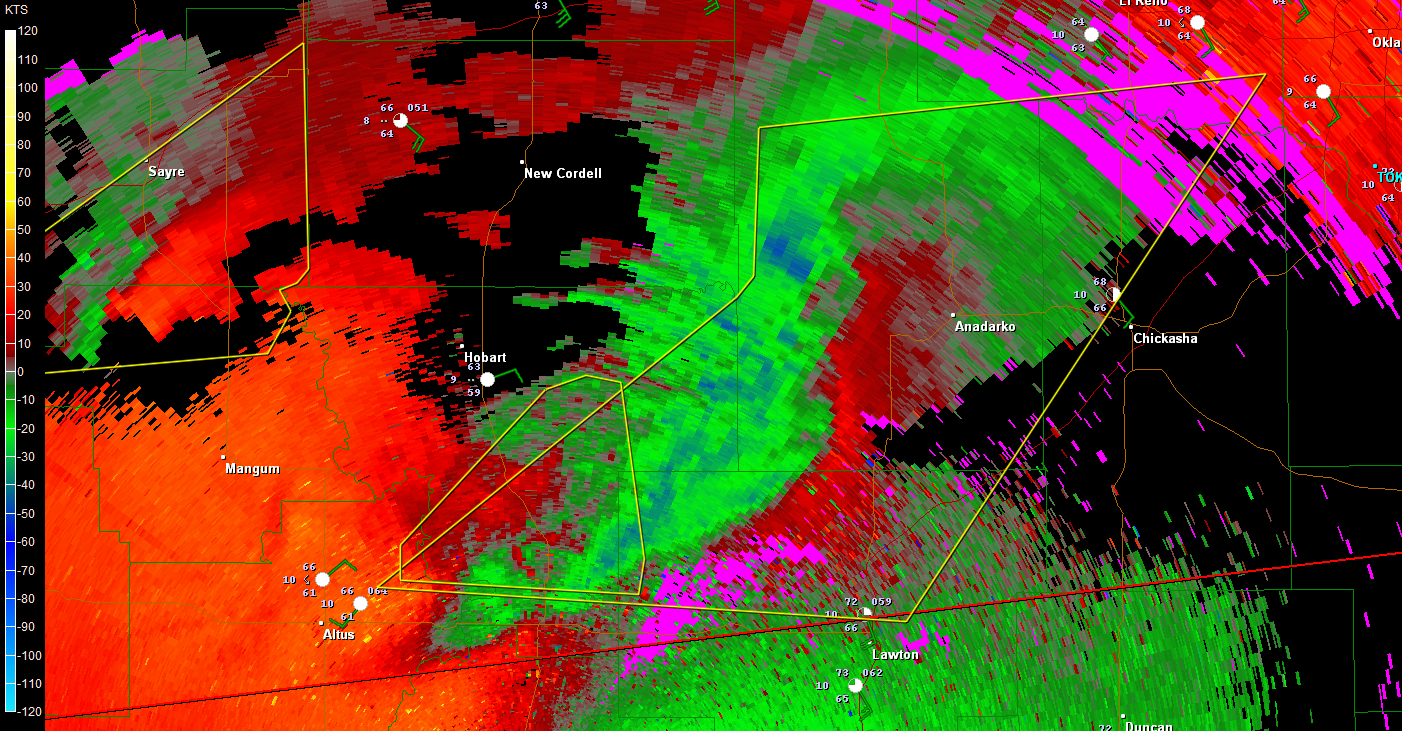
Here is a good radar image showing the dangers of high precip supercells. The reflectivity image is in b&w and transparent on the color image of the SRV (storm relative velocity, or basically the direction the winds are moving according to the radar, either away from or towards the radar). You can see that the circulation is embedded within some of the heaviest precip with the storm...this was the storm earlier as it impacted Blair, OK.

0 likes

Cannot impress enough how much of dangerous weather event will unfold tomorrow.
0 likes
The following post is NOT an official forecast and should not be used as such. It is just the opinion of the poster and may or may not be backed by sound meteorological data. It is NOT endorsed by any professional institution including storm2k.org For Official Information please refer to the NHC and NWS products.
-
brunota2003
- S2K Supporter
- Posts: 9476
- Age: 35
- Joined: Sat Jul 30, 2005 9:56 pm
- Location: Stanton, KY...formerly Havelock, NC
- Contact:
Also...some pretty high cloud tops, the storm just south of Sayre, OK (NWS Norman said on twitter they got a report of 3" hail from that storm just a few minutes ago) has cloud tops of up to 54k feet! In comparison, aircraft cruise between 32k and 38k feet! The top of that storm is 10.23 miles above the ground!
0 likes

I watched TWC and it was kind of down played but given what will be in play on saturday they shouldn't. There is so much energy going into the plains that violent tornadoes are likely and more then one seems likely as well also they will be long tracked.
Last edited by EF-5bigj on Fri Apr 13, 2012 10:08 pm, edited 1 time in total.
0 likes

Re: Re:
CrazyC83 wrote:NWS Norman is probably the most conservative office in issuing TOR's...
EF-5bigj wrote:I watched TWC and it was kind of down played but given what will be in play on saturday they shouldn't.
That's unfortunate.
Do you have the original color table set? If not I'd suggest using a different one.
Thanks, but I don't think I'm going to change it for now, just wanted to see what brunota2003 had.
RL3AO wrote:They probably have the luxury of being conservative today.
1. The atmosphere isn't as conductive for tornadoes tonight.
2. Don't want to overwarn tonight before the big show and have people write off tomorrow.
3. Theres 50 spotters on every cell...they will know if its producing a tornado.
1. The atmosphere should be way more conductive than last night, that's for sure.
2. I don't think overwarning is a problem, never heard of that (short-term).
3. Its dark now and hard to see.
4. I'm not comfortable with a conservative approach on a time-frame where "strong tornadoes are possible with cells that do form" in a setup.
0 likes
Return to “USA & Caribbean Weather”
Who is online
Users browsing this forum: txtwister78 and 168 guests