hasn't really been that impressive in the PDS watch and its non severe approaching the metro right now, does not look like a repeat of last weekend so far
could be another round later today however
Texas Summer 2019
Moderator: S2k Moderators
Forum rules

The posts in this forum are NOT official forecast and should not be used as such. They are just the opinion of the poster and may or may not be backed by sound meteorological data. They are NOT endorsed by any professional institution or STORM2K.


Re: Texas Summer 2019
DFW airport picked up 1.29" of rain overnight. Not too shabby.
2 likes
The above post and any post by Ntxw is NOT an official forecast and should not be used as such. It is just the opinion of the poster and may or may not be backed by sound meteorological data. It is NOT endorsed by any professional institution including Storm2k. For official information, please refer to NWS products.
Help support Storm2K!
-
BrokenGlassRepublicn
- Category 1

- Posts: 483
- Joined: Sun Nov 20, 2011 8:07 pm
- Location: Richardson, Texas
Re: Texas Summer 2019
Ntxw wrote:The rain we can do. No outflows and high winds like last Sunday please.
endorsed
1 likes
-
BrokenGlassRepublicn
- Category 1
- Posts: 483
- Joined: Sun Nov 20, 2011 8:07 pm
- Location: Richardson, Texas
-
Ralph's Weather
- S2K Supporter

- Posts: 3371
- Age: 38
- Joined: Fri Dec 13, 2013 11:55 am
- Location: Lindale, TX
- Contact:
Re: Texas Summer 2019
More rain/storms should develop over N TX today and congeal moving towards C and SE Texas. After a sizzling (sarcasm) weekend we are back to be being spoiled! Can't remember a mid June in TX with more greenery still.
2 likes
The above post and any post by Ntxw is NOT an official forecast and should not be used as such. It is just the opinion of the poster and may or may not be backed by sound meteorological data. It is NOT endorsed by any professional institution including Storm2k. For official information, please refer to NWS products.
Help support Storm2K!
Help support Storm2K!


Re: Texas Summer 2019
It remains very green and this spring's foliage explosion may have contributed to the downed branches/trees in N Dallas. Had power lines down in backyard here thanks to a fallen tree. Out for three days - was concerned it would be longer but Oncor wisely called in reinforcements. There were linemen from Odessa in our area. They did great. I hope we don't get a repeat of that event in the near future. The winds were strong and seemed to last a while - not just gusts.
0 likes
-
rwfromkansas
- Category 5

- Posts: 3032
- Joined: Sat Aug 27, 2005 12:47 am
- Location: North Fort Worth
Re: Texas Summer 2019
I didn’t even know it rained....slept right through. .70 here. Not bad for mid-June!!!
This reminds me of growing up in Kansas, in which you still could get good severe weather in June. July shut everything down usually.
This reminds me of growing up in Kansas, in which you still could get good severe weather in June. July shut everything down usually.
0 likes
Re: Texas Summer 2019
funster wrote:It remains very green and this spring's foliage explosion may have contributed to the downed branches/trees in N Dallas. Had power lines down in backyard here thanks to a fallen tree. Out for three days - was concerned it would be longer but Oncor wisely called in reinforcements. There were linemen from Odessa in our area. They did great. I hope we don't get a repeat of that event in the near future. The winds were strong and seemed to last a while - not just gusts.
The record wet Fall has really made it so on top of all the rain in the Spring. Watersheds and soils are as healthy as ever. Also with all the moisture the trees are holding can develop rot among other things to make them vulnerable to break. Really since 2015 we have experienced an abundant amount of water when the PDO flipped during the 2014-2016 big El Nino. This massive ENSO event re-arranged our decadal climate trends regarding rainfall. One of the wettest 5 years ever. For as dry as 2008-2014, 2015-present is equally wet and still ongoing.
2 likes
The above post and any post by Ntxw is NOT an official forecast and should not be used as such. It is just the opinion of the poster and may or may not be backed by sound meteorological data. It is NOT endorsed by any professional institution including Storm2k. For official information, please refer to NWS products.
Help support Storm2K!
Help support Storm2K!
-
bubba hotep

- S2K Supporter
- Posts: 6014
- Joined: Wed Dec 28, 2016 1:00 am
- Location: Collin County Texas
Re: Texas Summer 2019
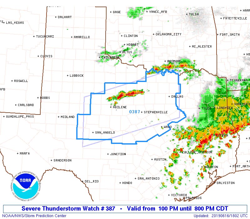
Bullseye in Central Texas

1 likes
Winter time post are almost exclusively focused on the DFW area.
-
Haris

- Category 5
- Posts: 1814
- Joined: Mon Nov 27, 2017 8:19 pm
- Location: ( Bee Cave) West Austin, Texas
Re: Texas Summer 2019
Buckle up... I have seen more actual severe storms this month than May or april lol
3 likes
Weather geek and a storm spotter in West Austin. Not a degreed meteorologist. Big snow fan. Love rain and cold! Despise heat!

Re: Texas Summer 2019
Is the atmosphere here in N. Texas going to be able to recover for afternoon storms?
0 likes
Re: Texas Summer 2019
newtotex wrote:Is the atmosphere here in N. Texas going to be able to recover for afternoon storms?
Plenty of moist air around displayed by high dewpoints. However short range guidance has struggled. Around and south of Shreveport is a long line of slow moving storms that were not modeled well.
We'll need to look to our west (Abilene) to see if there is redevelopment.
1 likes
The above post and any post by Ntxw is NOT an official forecast and should not be used as such. It is just the opinion of the poster and may or may not be backed by sound meteorological data. It is NOT endorsed by any professional institution including Storm2k. For official information, please refer to NWS products.
Help support Storm2K!
Help support Storm2K!
-
bubba hotep
- S2K Supporter
- Posts: 6014
- Joined: Wed Dec 28, 2016 1:00 am
- Location: Collin County Texas
-
rwfromkansas
- Category 5
- Posts: 3032
- Joined: Sat Aug 27, 2005 12:47 am
- Location: North Fort Worth
Re: Texas Summer 2019
I definitely didn’t think recovery would be an issue today. The storms came through very early.
1 likes
-
rwfromkansas
- Category 5
- Posts: 3032
- Joined: Sat Aug 27, 2005 12:47 am
- Location: North Fort Worth
Re: Texas Summer 2019
I love this new radar app I found Weather Lab. It has 3D and vertical cross-sections etc. Surprised I never heard of it!
0 likes
-
bubba hotep
- S2K Supporter
- Posts: 6014
- Joined: Wed Dec 28, 2016 1:00 am
- Location: Collin County Texas
Re: Texas Summer 2019
Mesoscale Precipitation Discussion 0430
NWS Weather Prediction Center College Park MD
253 PM EDT Sun Jun 16 2019
Areas affected...North Texas, Far Southern Oklahoma
Concerning...Heavy rainfall...Flash flooding possible
Valid 161851Z - 162230Z
Summary...Thunderstorms will increase in coverage this afternoon
and may produce some swaths of heavy rainfall. This may lead to
flash flooding, particularly in urbanized areas.
Discussion...Several bands of convection were evident on regional
radars as of 1830Z. The first was weaker, and less organized, just
north of the Red River in far S OK. Instability is more limited
further to the north, but nevertheless sufficient for somewhat
organized convection. RAP analyzed lifted parcel levels are around
1km, suggesting the storms are elevated with around 1500-2000 j/kg
of available CAPE. Although convection is weaker (with associated
lower rain rates), flash flood guidance is also reduced in this
area, suggesting that there may be some flash flood potential if
the storms can produce 2.5 to 3.5 inches of rain in three hours.
More robust flash flood potential exists further south, with
rapidly developing convection along a low-level convergence zone
from just northeast of ABI to near XBP. This convection was along
the northern edge of a pool of strong instability with GPS-PW
observations on the order of 1.6 to 1.8 inches. This combination
should support significant rain rates, likely reaching or
exceeding 2 in/hr at times. There should be some training
potential in the next couple hours as storms are essentially
oriented parallel to the deep layer mean flow vector. This would
be most likely to occur near and just E/SE of the current position
of the convective band, essentially encompassing areas near and
north of I-20 from Abilene to the DFW metro area through around
21Z. With time, as a larger convective line evolves, a cold pool
should become better established and the storms are more likely to
begin propagating southeast into the instability axis. This would
be typical with cold pool driven propagation beginning in earnest
about 3-5 hours after initial storm development. Additional flash
flooding could not be ruled out in those areas into the late
afternoon, but increased forward propagation may be a limiting
factor.
Lamers
0 likes
Winter time post are almost exclusively focused on the DFW area.
-
bubba hotep
- S2K Supporter
- Posts: 6014
- Joined: Wed Dec 28, 2016 1:00 am
- Location: Collin County Texas
Re: Texas Summer 2019
Based on SPC mesoanalysis, it looks like the atmosphere has decently recovered up along I35 in DFW and radar seems to be agreeing. Most all of the line out west is SVR warned.

0 likes
Winter time post are almost exclusively focused on the DFW area.
-
rwfromkansas
- Category 5
- Posts: 3032
- Joined: Sat Aug 27, 2005 12:47 am
- Location: North Fort Worth
-
bubba hotep
- S2K Supporter
- Posts: 6014
- Joined: Wed Dec 28, 2016 1:00 am
- Location: Collin County Texas
Re: Texas Summer 2019
In addition to the rain over the next 48hrs, the 12z Euro drops another 4-7" across DFW from dayas 3 - 10!
0 likes
Winter time post are almost exclusively focused on the DFW area.
Return to “USA & Caribbean Weather”
Who is online
Users browsing this forum: AnnularCane, Stratton23, txtwister78 and 92 guests