-Springfield, MO Tornado Outbreak, Miss Valley/G'Lakes
Moderator: S2k Moderators
Forum rules

The posts in this forum are NOT official forecast and should not be used as such. They are just the opinion of the poster and may or may not be backed by sound meteorological data. They are NOT endorsed by any professional institution or STORM2K.
-
JonathanBelles
- Professional-Met

- Posts: 11430
- Age: 35
- Joined: Sat Dec 24, 2005 9:00 pm
- Location: School: Florida State University (Tallahassee, FL) Home: St. Petersburg, Florida
- Contact:
-
brunota2003

- S2K Supporter

- Posts: 9476
- Age: 35
- Joined: Sat Jul 30, 2005 9:56 pm
- Location: Stanton, KY...formerly Havelock, NC
- Contact:

-
simplykristi
- S2K Supporter
- Posts: 1220
- Joined: Sat May 10, 2003 1:59 pm
- Location: Near KCMO
- Contact:
Re:
fact789 wrote:Any one who wants to come into chat, we are rolling warning and reports.
What's the link? I forgot.
Kristi
0 likes
Re: Re:
simplykristi wrote:fact789 wrote:Any one who wants to come into chat, we are rolling warning and reports.
What's the link? I forgot.
Kristi
http://www.esper.net/pjirc/storm2k.html
0 likes
-
JonathanBelles
- Professional-Met
- Posts: 11430
- Age: 35
- Joined: Sat Dec 24, 2005 9:00 pm
- Location: School: Florida State University (Tallahassee, FL) Home: St. Petersburg, Florida
- Contact:
Re: Re:
simplykristi wrote:fact789 wrote:Any one who wants to come into chat, we are rolling warning and reports.
What's the link? I forgot.
Kristi
there is a link at the top of this page.
0 likes
-
Category 5

- Category 5

- Posts: 10074
- Age: 36
- Joined: Sun Feb 11, 2007 10:00 pm
- Location: New Brunswick, NJ
- Contact:
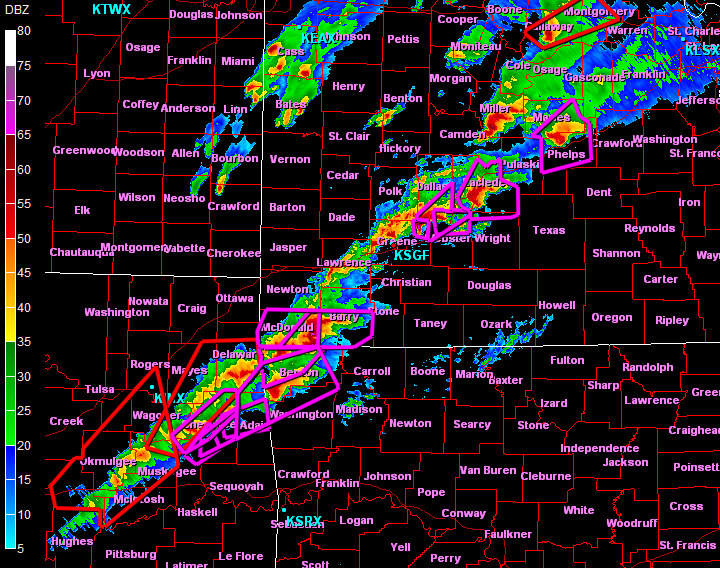
Re: -Springfield, MO Tornado Outbreak, Miss Valley/G'Lakes
000
NWUS53 KSGF 080230
LSRSGF
PRELIMINARY LOCAL STORM REPORT
NATIONAL WEATHER SERVICE SPRINGFIELD MO
830 PM CST MON JAN 07 2008
..TIME... ...EVENT... ...CITY LOCATION... ...LAT.LON...
..DATE... ....MAG.... ..COUNTY LOCATION..ST.. ...SOURCE....
..REMARKS..
0830 PM FUNNEL CLOUD 4 N STRAFFORD 37.33N 93.12W
01/07/2008 GREENE MO AMATEUR RADIO
FUNNEL CLOUD REPORTED OVER HIGHWAY 125 4 MILES NORTH OF
STRAFFORD.
0 likes
-
Category 5
- Category 5
- Posts: 10074
- Age: 36
- Joined: Sun Feb 11, 2007 10:00 pm
- Location: New Brunswick, NJ
- Contact:
Re: -Springfield, MO Tornado Outbreak, Miss Valley/G'Lakes
Yes, do join us in chat. We're discussing this right now, and rolling up to the minute updates.
0 likes
-
Category 5
- Category 5
- Posts: 10074
- Age: 36
- Joined: Sun Feb 11, 2007 10:00 pm
- Location: New Brunswick, NJ
- Contact:
Re: -Springfield, MO Tornado Outbreak, Miss Valley/G'Lakes
Quote from a reporter in the area
"Everything within a mile looks like it's been wiped off the face of the earth"
"Everything within a mile looks like it's been wiped off the face of the earth"
0 likes
-
CrazyC83
- Professional-Met
- Posts: 34315
- Joined: Tue Mar 07, 2006 11:57 pm
- Location: Deep South, for the first time!
MESOSCALE DISCUSSION 0021
NWS STORM PREDICTION CENTER NORMAN OK
0825 PM CST MON JAN 07 2008
AREAS AFFECTED...NERN OK THROUGH SERN KS AND W CNTRL THROUGH N CNTRL
MO
CONCERNING...TORNADO WATCH 3...4...
VALID 080225Z - 080330Z
THE SEVERE WEATHER THREAT FOR TORNADO WATCH 3...4...CONTINUES.
REMAINING PORTIONS OF WW 0001 WHICH EXPIRES AT 03Z AND WW 0003 WHICH
EXPIRES AT 04Z WILL PROBABLY NEED TO BE REPLACED BY ANOTHER WW SOON.
PRIMARY AXIS OF TORNADIC SUPERCELLS CONTINUES FROM NERN OK NEWD
THROUGH SWRN AND CNTRL MO WITHIN PDS TORNADO WATCH. FARTHER WEST...A
NARROW CORRIDOR OF INSTABILITY REMAINS BETWEEN THIS ACTIVITY AND THE
COLD FRONT WHICH EXTENDS FROM NRN MO SWWD THROUGH SERN KS INTO NWRN
OK. THE LARGEST LOW LEVEL HODOGRAPHS WILL REMAIN IN PDS WATCH AREA
TONIGHT. HOWEVER...DEEP SHEAR WILL BE SUFFICIENT FOR ORGANIZED STORM
STRUCTURES AND SUPERCELLS WITH ACTIVITY DEVELOPING FARTHER NW AND IN
CLOSER PROXIMITY TO THE FRONT. STORMS MAY INCREASE IN COVERAGE
WITHIN THIS ZONE AS ASCENT AND STEEP LAPSE RATES ASSOCIATED WITH
SHORTWAVE THROUGH OVER OK ADVANCES EWD. PRIMARY THREATS WILL
PROBABLY BE ISOLATED LARGE HAIL AND DAMAGING WIND GUSTS...BUT
ISOLATED TORNADOES CANNOT BE RULED OUT.
..DIAL.. 01/08/2008
ATTN...WFO...SGF...EAX...TSA...TOP...ICT...OUN...
36679497 35359635 35189709 35749722 36699696 38329471
40119268 39229247
0 likes
-
MiamiensisWx
Re: -Springfield, MO Tornado Outbreak, Miss Valley/G'Lakes
Chicago, IL hit 65 degrees F today... that's incredible warmth (36 degrees above average!) for that area during January, and it illustrates the extent of "fuel" for this outbreak.
0 likes
-
MiamiensisWx
-
CrazyC83
- Professional-Met
- Posts: 34315
- Joined: Tue Mar 07, 2006 11:57 pm
- Location: Deep South, for the first time!
Re:
MiamiensisWx wrote:The OK and SW MO cells appear to be congealing into a squall line. Hopefully, that is the case for Springfield's sake and other areas...
I'd watch for new supercells to form ahead of the line, and to the south...
0 likes
-
MiamiensisWx
Re: -Springfield, MO Tornado Outbreak, Miss Valley/G'Lakes
There's one report via WBBM radio (according to one poster on another board) that indicates "entire subdivisions obliterated" across Kenosha County.
0 likes
-
jasons2k

- Storm2k Executive

- Posts: 8290
- Age: 52
- Joined: Wed Jul 06, 2005 12:32 pm
- Location: The Woodlands, TX
Wow, I didn't realize it was this bad...
I can say the LLJ south of the system is really cranking; it's incredibly windy here in Houston, especially for it being after sunset. It's like April outside.
Kudos to Ed for nailing Springfield earlier.
Here's news from Kenosha: http://www.kenoshanews.com/
I can say the LLJ south of the system is really cranking; it's incredibly windy here in Houston, especially for it being after sunset. It's like April outside.
Kudos to Ed for nailing Springfield earlier.
Here's news from Kenosha: http://www.kenoshanews.com/
0 likes
-
Category 5
- Category 5
- Posts: 10074
- Age: 36
- Joined: Sun Feb 11, 2007 10:00 pm
- Location: New Brunswick, NJ
- Contact:
Re: -Springfield, MO Tornado Outbreak, Miss Valley/G'Lakes
Thats 2 EF4's it looks like now. One in MO and one in WI.
0 likes


Re: -Springfield, MO Tornado Outbreak, Miss Valley/G'Lakes
Hey can y'all tell me if any tornados have hit Springfield. My stepdaughter lives there and it looks bad from what I saw on the online tv station sites. She lives over on Grand St. near the Kansas Expressway? Over near Fort St. Any info would be great. WE are down in TExas and not much news going on here about what is happening there.
0 likes
-
MiamiensisWx
Re: -Springfield, MO Tornado Outbreak, Miss Valley/G'Lakes
ETXHAMXYL wrote:Hey can y'all tell me if any tornados have hit Springfield. My stepdaughter lives there and it looks bad from what I saw on the online tv station sites. She lives over on Grand St. near the Kansas Expressway? Over near Fort St. Any info would be great. WE are down in TExas and not much news going on here about what is happening there.
There have been (at least) two tornadoes in the Springfield area, including one reported rope tornado (briefly lifted) near the airport and a large one through the city. I'm not certain about the effects at her location; I need more information from local sources and other data.
Last edited by MiamiensisWx on Mon Jan 07, 2008 9:52 pm, edited 1 time in total.
0 likes
-
Category 5
- Category 5
- Posts: 10074
- Age: 36
- Joined: Sun Feb 11, 2007 10:00 pm
- Location: New Brunswick, NJ
- Contact:
Re: -Springfield, MO Tornado Outbreak, Miss Valley/G'Lakes
ETXHAMXYL wrote:Hey can y'all tell me if any tornados have hit Springfield. My stepdaughter lives there and it looks bad from what I saw on the online tv station sites. She lives over on Grand St. near the Kansas Expressway? Over near Fort St. Any info would be great. WE are down in TExas and not much news going on here about what is happening there.
All I have right now
0126 SPRINGFIELD GREENE MO 3720 9329 TORNADO AT JAMES RIVER AND KANSAS EXPRESSWAY NEAR CHESTERFIELD VILLAGE (SGF)
0 likes

Re: -Springfield, MO Tornado Outbreak, Miss Valley/G'Lakes
ETXHAMXYL wrote:Hey can y'all tell me if any tornados have hit Springfield. My stepdaughter lives there and it looks bad from what I saw on the online tv station sites. She lives over on Grand St. near the Kansas Expressway? Over near Fort St. Any info would be great. WE are down in TExas and not much news going on here about what is happening there.
I know that it definately hit.
0 likes
Return to “USA & Caribbean Weather”
Who is online
Users browsing this forum: UTSARoadrunner4 and 99 guests