Texas Fall-2015

U.S. & Caribbean Weather Discussions and Severe Weather Events

Moderator: S2k Moderators

Forum rules

The posts in this forum are NOT official forecast and should not be used as such. They are just the opinion of the poster and may or may not be backed by sound meteorological data. They are NOT endorsed by any professional institution or STORM2K.

Help Support Storm2K
Message
Author
User avatar
TheProfessor
Professional-Met
Professional-Met
Posts: 3506
Age: 28
Joined: Tue Dec 03, 2013 10:56 am
Location: Wichita, Kansas

Re: Texas Fall-2015

#2201 Postby TheProfessor » Sat Nov 21, 2015 1:30 am

TarrantWx wrote:
TheProfessor wrote:
Brent wrote:This run doesn't have nearly the precip on Saturday when it's cold enough it appears as the 18z. Just a brief window Friday Night actually, the precip is gone on Saturday morning.

and actually even then temps are above freezing in most of the metro. There is freezing temps just west of the metro though.


I like this run. :D


C'mon man... You can't go from rooting for winter weather in Texas to suddenly being against it. The rest of us don't get to spend our winter in Ohio. I'm sure your professors will allow you to make up a test if your flight is cancelled because of a winter storm in Texas. Because if what some of the models runs have been showing actually comes to fruition, you won't be the only one who gets stranded after Thanksgiving. So just enjoy it if it happens while you're here. And look at it this way... extra study time.


If this were high school I would say sure why not, or even if I were later into school where I'm more personal with the hierarchy of an office. But I'm a Freshman, and I already get an extra day for taking my test becaus I have a disability and trying to get that straigten out with the head professor and the disability office is an unknown thing, I'm all for winter weather, heck I don't mind it snowing, but I don't want anything near 2013, beacause now I'm taking a midterm a week before finals and I'm missing very important Physics lectures. Some of those Thermo Dynamics calculations are tough.

Edit: I'll be back in Texas on December 15th, it can snow all it wants then.
0 likes   
An alumnus of The Ohio State University.

Your local National Weather Service office is your best source for weather information.

User avatar
Ntxw
Storm2k Moderator
Storm2k Moderator
Posts: 22784
Joined: Wed Oct 21, 2009 6:34 pm
Location: DFW, Texas

Re: Texas Fall-2015

#2202 Postby Ntxw » Sat Nov 21, 2015 1:32 am

Brent wrote:The GFS has the next one lined up around 300 hours. :P

No boring times in the weather dept... and temps stay quite cold.

http://www.tropicaltidbits.com/analysis ... _us_45.png


We are very lucky with the Nino climo. There are already hints of the EPS and GEFS of that torch in Canada crawling into the northern US once the EPO exits. In short more record warmth up there is possible for areas that have already seen it relative to averages while the island of cool to cold anomalies are in the southwest and southern plains.

Image
0 likes   
The above post and any post by Ntxw is NOT an official forecast and should not be used as such. It is just the opinion of the poster and may or may not be backed by sound meteorological data. It is NOT endorsed by any professional institution including Storm2k. For official information, please refer to NWS products.

  Help support Storm2K!
Help Support Storm2K

User avatar
SouthernMet
Category 3
Category 3
Posts: 857
Joined: Sun Aug 29, 2010 8:23 pm
Location: fort worth, tx

Re: Texas Fall-2015

#2203 Postby SouthernMet » Sat Nov 21, 2015 3:08 am

Don't think I saw it posted yet... Tonight's CMC

Image
0 likes   
Nothing that SouthernMet posts, is an official forecast,nor does it reflect views of STORM2K.. SouthernMet is just adding to the great discussions on STORM2K.. Refer to NWS for official forecasts.

User avatar
TheProfessor
Professional-Met
Professional-Met
Posts: 3506
Age: 28
Joined: Tue Dec 03, 2013 10:56 am
Location: Wichita, Kansas

#2204 Postby TheProfessor » Sat Nov 21, 2015 9:49 am

:uarrow: I wouldn't want to be near the border of the rain and ice on that run, because we all know that the models tend to struggle with the shallow cold air and how fast it arrives.
0 likes   
An alumnus of The Ohio State University.

Your local National Weather Service office is your best source for weather information.

User avatar
TexasF6
S2K Supporter
S2K Supporter
Posts: 816
Joined: Mon Aug 09, 2004 9:33 pm
Location: Austin, TX

Re: Texas Fall-2015

#2205 Postby TexasF6 » Sat Nov 21, 2015 10:17 am

Did you guys see the last GFS run!!!!!!???????????????????????????? ICE DOWN TO THE COAST!!!!! (hour 192) SNOWSTORM FOR ME & PORTA!!!!!! Ok, I'm calm now. Breathing. Going to the Farmer's Market. With a skip in my step!!!!! :cold: :cold: :cold: :flag:
0 likes   
This is not an official forecast, follow the NWS for official products!!!

User avatar
Ntxw
Storm2k Moderator
Storm2k Moderator
Posts: 22784
Joined: Wed Oct 21, 2009 6:34 pm
Location: DFW, Texas

#2206 Postby Ntxw » Sat Nov 21, 2015 10:32 am

Forget next week it feels like winter out there now, woo nippy winds :cold:
0 likes   
The above post and any post by Ntxw is NOT an official forecast and should not be used as such. It is just the opinion of the poster and may or may not be backed by sound meteorological data. It is NOT endorsed by any professional institution including Storm2k. For official information, please refer to NWS products.


  Help support Storm2K!

Help Support Storm2K


User avatar
Tireman4
S2K Supporter
S2K Supporter
Posts: 5853
Age: 59
Joined: Fri Jun 30, 2006 1:08 pm
Location: Humble, Texas
Contact:

Re: Texas Fall-2015

#2207 Postby Tireman4 » Sat Nov 21, 2015 10:32 am

[quote="TexasF6"]Did you guys see the last GFS run!!!!!!???????????????????????????? ICE DOWN TO THE COAST!!!!! (hour 192) SNOWSTORM FOR ME & PORTA!!!!!! Ok, I'm calm now. Breathing. Going to the Farmer's Market. With a skip in my step!!!!! :cold: :cold: :cold: :flag:[/quo


Yea Porta and Texas F6
0 likes   

User avatar
Tireman4
S2K Supporter
S2K Supporter
Posts: 5853
Age: 59
Joined: Fri Jun 30, 2006 1:08 pm
Location: Humble, Texas
Contact:

Re:

#2208 Postby Tireman4 » Sat Nov 21, 2015 10:33 am

Ntxw wrote:Forget next week it feels like winter out there now, woo nippy winds :cold:


Yeah...not here...not yet...but my 5 pm run will be glorious
0 likes   

User avatar
TheProfessor
Professional-Met
Professional-Met
Posts: 3506
Age: 28
Joined: Tue Dec 03, 2013 10:56 am
Location: Wichita, Kansas

#2209 Postby TheProfessor » Sat Nov 21, 2015 10:39 am

43 degrees here, 80% chance of rain/snow tonight, most of it won't stick though.
0 likes   
An alumnus of The Ohio State University.

Your local National Weather Service office is your best source for weather information.

User avatar
Rgv20
S2K Supporter
S2K Supporter
Posts: 2466
Age: 38
Joined: Wed Jan 05, 2011 5:42 pm
Location: Edinburg/McAllen Tx

#2210 Postby Rgv20 » Sat Nov 21, 2015 10:41 am

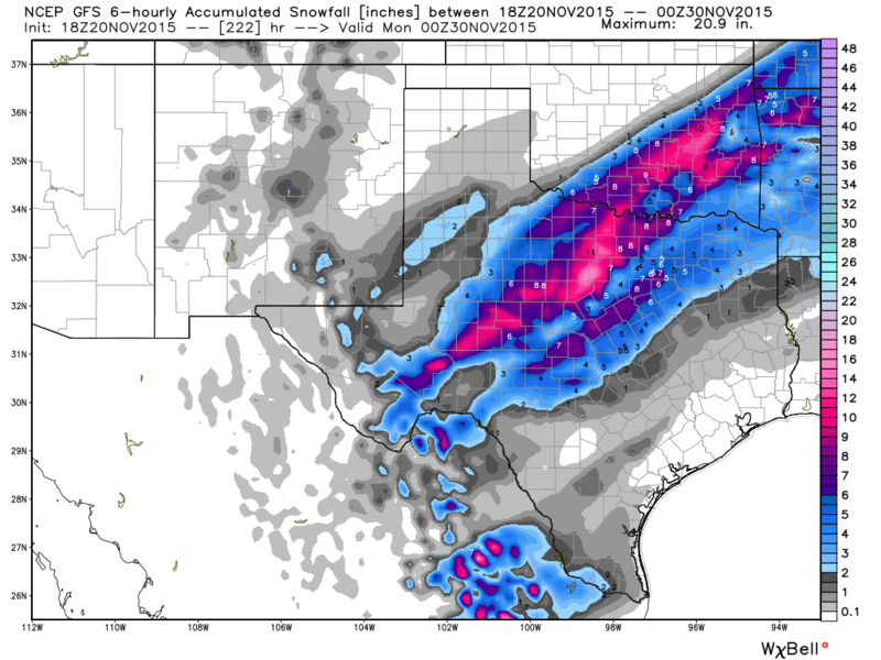
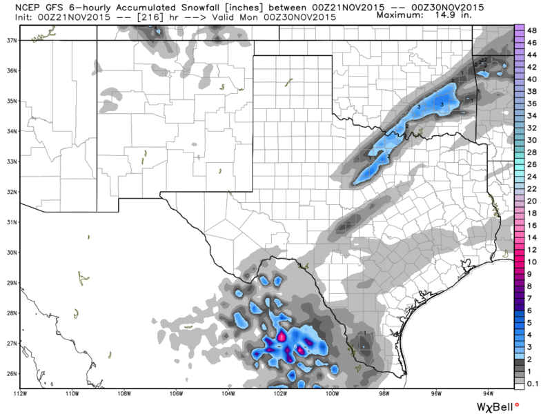
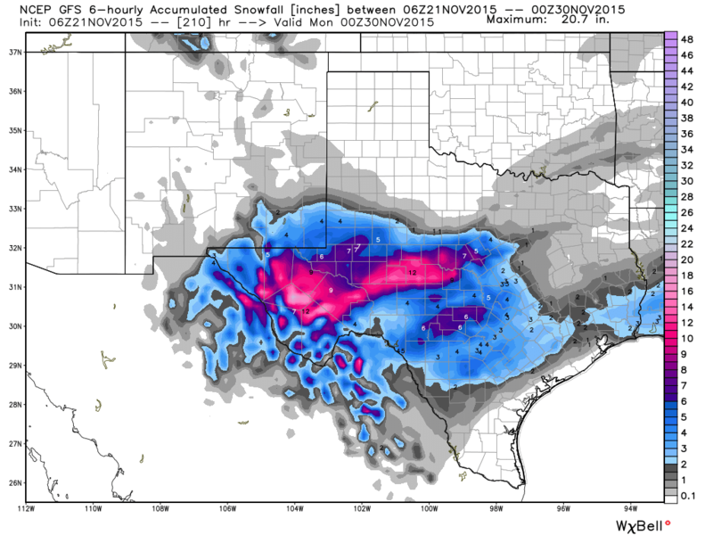
I think the GFS is trying to hint at something.. :cold: This is the last three runs of the GFS, forecast snowfall ending Sunday Evening! :D

Yesterday's 18zGFS
Image

0zGFS
Image

6zGFS
Image
0 likes   
The following post is NOT an official forecast and should not be used as such. It is just the opinion of the poster and may or may not be backed by sound meteorological data. It is NOT endorsed by any professional institution including storm2k.org For Official Information please refer to the NHC and NWS products.

User avatar
Portastorm
Storm2k Moderator
Storm2k Moderator
Posts: 9914
Age: 63
Joined: Fri Jul 11, 2003 9:16 am
Location: Round Rock, TX
Contact:

Re: Texas Fall-2015

#2211 Postby Portastorm » Sat Nov 21, 2015 10:45 am

TexasF6 wrote:Did you guys see the last GFS run!!!!!!???????????????????????????? ICE DOWN TO THE COAST!!!!! (hour 192) SNOWSTORM FOR ME & PORTA!!!!!! Ok, I'm calm now. Breathing. Going to the Farmer's Market. With a skip in my step!!!!! :cold: :cold: :cold: :flag:


TexasF6 - I love your spirit, brother ... but ... better chance my Longhorns get into a bowl game than frozen stuff falling on us next weekend.

We shall see.

I'm headed to Waco soon for our high school football playoff game at 2 pm. Going to be blustery out there but being the team statistician has its perks ... I'll be in the press box. :wink:

Have a great Saturday, folks!
0 likes   
Any forecasts under my name are to be taken with a grain of salt. Get your best forecasts from the National Weather Service and National Hurricane Center.

BigB0882
S2K Supporter
S2K Supporter
Posts: 2284
Joined: Thu Jul 03, 2003 12:08 am
Location: Baton Rouge, LA
Contact:

#2212 Postby BigB0882 » Sat Nov 21, 2015 11:36 am

Can anyone post the 6z GFS snowfall map including the state of Louisiana? It would be appreciated. :)
0 likes   

User avatar
TheProfessor
Professional-Met
Professional-Met
Posts: 3506
Age: 28
Joined: Tue Dec 03, 2013 10:56 am
Location: Wichita, Kansas

#2213 Postby TheProfessor » Sat Nov 21, 2015 11:50 am

It would seem that the last few GFS runs is supressing the moisture after the cold arrives, new trend?
0 likes   
An alumnus of The Ohio State University.

Your local National Weather Service office is your best source for weather information.

User avatar
TheProfessor
Professional-Met
Professional-Met
Posts: 3506
Age: 28
Joined: Tue Dec 03, 2013 10:56 am
Location: Wichita, Kansas

#2214 Postby TheProfessor » Sat Nov 21, 2015 12:03 pm

CMC still has Icestorm for the Western Half of DFW it looks like, I sure hope it's trying to live up to it's name the Crazy Canadian.
0 likes   
An alumnus of The Ohio State University.

Your local National Weather Service office is your best source for weather information.

User avatar
srainhoutx
S2K Supporter
S2K Supporter
Posts: 6919
Age: 67
Joined: Sun Jan 14, 2007 11:34 am
Location: Haywood County, NC
Contact:

Re:

#2215 Postby srainhoutx » Sat Nov 21, 2015 12:08 pm

TheProfessor wrote:It would seem that the last few GFS runs is supressing the moisture after the cold arrives, new trend?


Not likely...

EXTENDED FORECAST DISCUSSION
NWS WEATHER PREDICTION CENTER COLLEGE PARK MD
1028 AM EST SAT NOV 21 2015

VALID 12Z TUE NOV 24 2015 - 12Z SAT NOV 28 2015

...WRN TO CENTRAL US HEAVY SNOW AND RAIN THREAT FOR THANKSGIVING
HOLIDAY TRAVELERS...


...GUIDANCE/UNCERTAINTY ASSESSMENT...

THE WPC MEDIUM RANGE FORECAST SUITE OFFERS GOOD CONTINUITY AS
DERIVED PRIMARILY FROM A COMPOSITE OF WELL CLUSTERED GUIDANCE FROM
THE 06 UTC GFS/GEFS MEAN AND 00 UTC UKMET/ECMWF/ECMWF ENSEMBLE
MEAN TUE INTO EARLY FRI. FORECAST CONFIDENCE IS ABOVE AVERAGE
DURING THIS PERIOD. CHANGED TO A 50-50 BLEND OF REASONABLY
COMPATABLE GUIDANCE FROM THE 06 UTC GEFS MEAN AND 00 UTC ECMWF
ENSEMBLE MEAN LATER FRI INTO SAT CONSISTENT WITH GRADUALLY
INCREASING FORECAST SPREAD AND NO BETTER THAN AVERAGE
PREDICTABILITY.

IT REMAINS LIKELY THAT DEVELOPMENT OF A VERY AMPLIFIED PATTERN
WILL BRING MUCH BELOW NORMAL TEMPS/STRONG WINDS ACROSS THE
WRN-CNTRL STATES WITH SOME AREAS HAVING THE POTENTIAL FOR HEAVY
SNOW. HVY RNFL/STRONG CONVECTION SHOULD DEVELOP OVER THE PLAINS/MS
VLY JUST AHEAD OF THE COLD SURGE. ACTIVE WEATHER WILL LEAD TO
TRAVEL DIFFICULTIES DURING THE THANKSGIVING HOLIDAY PERIOD. THE
SUPPORTING WRN TROUGH/EMBEDDED UPR LOW IS HANDLED FAIRLY WELL INTO
THU...BUT STEADILY INCREASING SPREAD ACROSS THE NRN/ERN PAC AND
CANADA LEAD TO QUESTION MARKS WITH FCST DETAILS THEREAFTER.
INDIVIDUAL MODEL RUNS/ENSEMBLE MEMBERS CONTINUE TO SHOW
CONSIDERABLE SPREAD WITH NRN PAC FLOW HEADING INTO/AROUND THE
STRONG NERN PAC/WRN CANADA RIDGE AS WELL AS WITH THE DOWNSTREAM
TROUGH OVER CANADA. THESE DIFFS SUGGEST A VARIETY OF POSSIBILITIES
FOR FLOW DETAILS JUST OFF THE WEST COAST AS WELL AS ACROSS THE
LOWER 48 AND CANADA BY LATER IN THE WEEK/WEEKEND.

...SENSIBLE WEATHER HIGHLIGHTS...

A POTENT SURGE OF COLD AIR SURGING SWD/SEWD ACROSS THE WEST AND
PLAINS BRINGS AREAS OF SNOW AND WIDESPREAD MINUS 10-25F ANOMALIES
FOR HIGHS WITH THE MOST EXTREME VALUES VS NORMAL TENDING TO BE
OVER THE ERN SLOPES OF THE NRN-CNTRL ROCKIES AND HIGH PLAINS.
STRONG WINDS WILL LIKELY PRODUCE LOW WIND CHILL VALUES AND LEAD TO
BLOWING SNOW OVER SOME AREAS. JUST AHEAD OF THE SLOW MOVING WAVY
SFC FRONT OVER THE PLAINS...MOISTURE CARRIED BY GULF INFLOW WILL
CONTRIBUTE TO INCREASINGLY HVY RNFL/CONVECTION OVER PARTS OF THE
PLAINS/MS VLY BY THE LATTER HALF OF THE WEEK. UNCERTAINTIES IN
FLOW DETAILS ALOFT BY THAT TIME TEMPER CONFIDENCE IN DETERMINING
HOW MUCH MOISTURE MAY EXTEND BACK INTO THE COLD SECTOR AND FALL AS
WINTRY PCPN...BUT A REAL THREAT FOR SIGNIFICANT SNOWS EXIST AS
AIDED BY UNCERTAIN WAVE GENESIS.
ELSEWHERE ASIDE FROM ONSHORE FLOW
LEADING TO LGT RNFL ALONG THE ERN COAST OF FL...MOST OF THE EAST
SHOULD BE DRY THANKS TO A STRONG RIDGE AT THE SURFACE AND ALOFT.
ERN TEMPS SHOULD TREND WARMER AFTER A COOL START TUE.

SCHICHTEL


0 likes   
Carla/Alicia/Jerry(In The Eye)/Michelle/Charley/Ivan/Dennis/Katrina/Rita/Wilma/Ike/Harvey

Member: National Weather Association
Wx Infinity Forums
http://wxinfinity.com/index.php

Facebook.com/WeatherInfinity
Twitter @WeatherInfinity

hfriverajr

Re: Texas Fall-2015

#2216 Postby hfriverajr » Sat Nov 21, 2015 12:11 pm

Portastorm wrote:
TexasF6 wrote:Did you guys see the last GFS run!!!!!!???????????????????????????? ICE DOWN TO THE COAST!!!!! (hour 192) SNOWSTORM FOR ME & PORTA!!!!!! Ok, I'm calm now. Breathing. Going to the Farmer's Market. With a skip in my step!!!!! :cold: :cold: :cold: :flag:


TexasF6 - I love your spirit, brother ... but ... better chance my Longhorns get into a bowl game than frozen stuff falling on us next weekend.

We shall see.

I'm headed to Waco soon for our high school football playoff game at 2 pm. Going to be blustery out there but being the team statistician has its perks ... I'll be in the press box. :wink:

Have a great Saturday, folks!


Porta be optimistic! I have a good feeling about it..heheh
0 likes   

User avatar
TheProfessor
Professional-Met
Professional-Met
Posts: 3506
Age: 28
Joined: Tue Dec 03, 2013 10:56 am
Location: Wichita, Kansas

Re: Re:

#2217 Postby TheProfessor » Sat Nov 21, 2015 12:12 pm

srainhoutx wrote:
TheProfessor wrote:It would seem that the last few GFS runs is supressing the moisture after the cold arrives, new trend?


Not likely...


[/i]

I'm just -removed-, I like the last 3 GFS runs, but they'll probably flip again tomorrow. :roll:
0 likes   
An alumnus of The Ohio State University.

Your local National Weather Service office is your best source for weather information.

User avatar
PTrackerLA
Category 5
Category 5
Posts: 5277
Age: 41
Joined: Thu Oct 10, 2002 8:40 pm
Location: Lafayette, LA

Re: Texas Fall-2015

#2218 Postby PTrackerLA » Sat Nov 21, 2015 12:15 pm

Looks like the 12z GFS has gotten a reality check and basically scraps the major winter storm all the way to the gulf coast for Thanksgiving weekend. The 00z Euro was a lot warmer than even the 12z (ex: DFW never goes below freezing next weekend.) Don't get too excited yet, after all it's just November 8-) .
0 likes   

User avatar
Ntxw
Storm2k Moderator
Storm2k Moderator
Posts: 22784
Joined: Wed Oct 21, 2009 6:34 pm
Location: DFW, Texas

#2219 Postby Ntxw » Sat Nov 21, 2015 12:16 pm

As long as Portastorm sees snow and I get my Houston early cutoff low snowfall prediction to fruition I'm happy :cheesy:
0 likes   
The above post and any post by Ntxw is NOT an official forecast and should not be used as such. It is just the opinion of the poster and may or may not be backed by sound meteorological data. It is NOT endorsed by any professional institution including Storm2k. For official information, please refer to NWS products.


  Help support Storm2K!

Help Support Storm2K


User avatar
Ntxw
Storm2k Moderator
Storm2k Moderator
Posts: 22784
Joined: Wed Oct 21, 2009 6:34 pm
Location: DFW, Texas

Re: Texas Fall-2015

#2220 Postby Ntxw » Sat Nov 21, 2015 12:17 pm

PTrackerLA wrote:Looks like the 12z GFS has gotten a reality check and basically scraps the major winter storm all the way to the gulf coast for Thanksgiving weekend. The 00z Euro was a lot warmer than even the 12z (ex: DFW never goes below freezing next weekend.) Don't get too excited yet, after all it's just November 8-) .


I don't buy the run's DFW doesn't get to freezing. Run of the mill front this weekend is getting us to freezing.
0 likes   
The above post and any post by Ntxw is NOT an official forecast and should not be used as such. It is just the opinion of the poster and may or may not be backed by sound meteorological data. It is NOT endorsed by any professional institution including Storm2k. For official information, please refer to NWS products.


  Help support Storm2K!

Help Support Storm2K


Return to “USA & Caribbean Weather”

Who is online

Users browsing this forum: Brushcountry and 20 guests