Hey, all new and exciting next week severe thread for the South Plains. GFS shows potential excitement with impressive low level wind dynamics Friday afternoon!
Oh, never mind, you found it...
Moderator: S2k Moderators


.Confidence growing in a significant rainfall event at the end of the week into the weekend.
High pressure is in firm control today through Wednesday and then will begin to shift eastward late Wednesday allowing SE flow to bring Gulf moisture back into the region. Upper level pattern will undergo a major transition toward the end of the week from the fast paced progressive flow of late toward a more blocky pattern. A large upper level trough drops into the SW US and attempts to close off from the main flow. This places Texas in a very favorable upper air pattern with an active sub-tropical jet stream overhead for several rounds of heavy rainfall and severe thunderstorms.
Will trend toward the slower solution of the ejection of the storm system into the plains late this week and trend weather toward that solution. Expect good moisture return by midday Thursday as Gulf opens up allowing 1.5-1.8 inch PWS to surge into the region. Combined with good mid and high level moisture from the Pacific and disturbances rotating around the ESE side of the upper low spells active weather by Thursday afternoon. Expect dry line storms to fire in the heat of the afternoon as increasing moisture results in an increasingly unstable air mass. Storms could make a run for our western counties before falling apart late in the evening.
Friday looks like a fairly significant event as a strong disturbance rotates out of NE Mexico across TX. Parameters favor an extended period of training storms across the area Friday into Friday night. Given near 2.0 inch PWS values and potential for repeat cell training flash flooding will be a threat even given dry ground conditions.
Storm chances will linger into Saturday night before a Pacific cold front crosses the area on Sunday. Hard to pin point at this range the exact amounts and locations of the heaviest rains…meso scale features such as outflow boundaries may dictate much of this toward the end of the week.
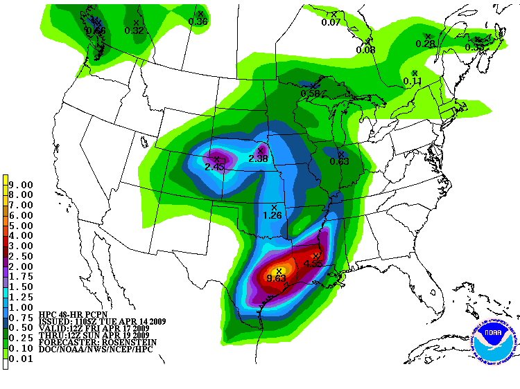
Model QPF and HPC QPF are very hefty toward the end of the week with 5 day totals nearing 4-8 inches across a large part of SE into N TX. Feel such amounts are possible on an isolated scale given the available moisture supply and threat for cell training. For now will go with a widespread 1-3” all areas from Thurs-Sun with isolated amounts of 4-6”. Stay Tuned


Heavy rainfall/severe event possible late this week into Saturday.
Upper air pattern shift is underway this morning as fast paced progressive pattern of late undergoes slowing allowing the next western US storm system to move into the plains and slow down. Surface ridge is moving eastward this morning resulting in a return of SE low level flow across the state. Deep tropical moisture is pooling over the southern Gulf of Mexico and will begin to surge northward tonight and early Thursday.
Thursday:
Aggressive warm air advection pattern becomes established as large SW US storm system forces lowering pressures over W TX. Low level jet of 35-45kts will pump tropical moisture into the region. While model soundings show a 850mb capping inversion, feel a good influx of moisture will result in scattered showers under the cap. Dry line will likely fire off over C TX late in the afternoon and some of these storms may make a run for our western counties.
Large MCS is shown to develop late Thursday night from N TX back into C TX along dry line and ahead of a potent short wave ejecting around the southern side of the large upper air storm system. Air mass across SE TX will become very unstable ahead of this convective complex.
Friday:
Large scale MCS should be ongoing early in the morning from NE TX back toward Del Rio. While models are suffering from convective feedback feel this band of storms will drive SE during the day…possibly faster than model predictions given past experiences with MCS activity. Air mass over the region will be strongly sheared and very unstable as mid level cooling results in steep lapse rates and vigorous development. Feel MCS will slow as it moves southeastward into an increasingly parallel upper air flow out of the SW. Potential is there for the MCS to nearly stall out Friday across the area as the leading gust front/outflow boundary impinges on strong SE flow at the surface and SW flow aloft. Potential will increase for cell training along the leading edge of the line with widespread showers and thunderstorms behind the line. Since we are dealing with the meso scale the location of the heaviest rainfall is impossible to predict. While models are keying in on a W to E low level boundary across the area…I feel they are picking up on the outflow boundary from the MCS and where this decides to pull up stationary is unpredictable. Linear nature of the line should result in mainly a large hail and wind damage threat. May see some development out ahead of the complex and these cell…possibly supercellular in nature could pose a tornadic risk.
Saturday:
Activity for Saturday will be controlled by what happens on Friday. While the upper low remains to our west and models show a favorable rain producing pattern…Friday MCS if is sweeps the entire area may take good moisture with it and overturn the boundary layer resulting in a stabilized air mass. With enough heating the air mass will recharge and become unstable once again. Low level boundaries laying across the area could be the needed surface focus to set things off. Will play the wait and see game for Saturday depending on the evolution of the Friday event which seems most likely at this moment. Models show a potentially unstable air mass for Saturday so once again severe weather will be possible.
QPF:
3 day rainfall totals of 2-4 inches will be common with isolated amounts of up to 6 inches. Given increasing PWS values of 1.6-1.9 inches Friday and the threat for slow moving of repeat cell training could produce some hefty totals. Forecasting rule using PWS and slow moving <than 10kts for organized convection suggest rainfall amounts of 2-6 inches. Given the amounts of moisture that will be available I would not discount some very high totals in a short period of time. While grounds are dry from ongoing drought conditions excessive short term rainfall will lead to potential urban flooding issues. Additionally, grounds will saturate over time lending greater run-off each day.


srainhoutx wrote:Could be an "interesting weekend" for those involved in the MS 150 Bike Ride from Houston to Austin.
Ed Mahmoud wrote:srainhoutx wrote:Could be an "interesting weekend" for those involved in the MS 150 Bike Ride from Houston to Austin.
Are you allowed to link to the "local" forum?
I've been monitoring the long-range progs for the past few weeks, moving onto the medium-range progs more recently. Here are the common themes for the past 2 weeks:
1. A stationary front between Houston and Austin on Saturday
2. That front moves east of La Grange Saturday night, leaving Sunday's ride from La Grange to Austin with sunny but cool weather.
Ok, so the good news is that Sunday consistently looks sunny and dry. The bad news is potentially Saturday. An upper-level disturbance will pass to the north of the route on Friday, perhaps spawning a line of showers/storms that could affect parts of the route on Friday. This disturbance moves off to the northeast by Friday evening, and the rain temporarily ends.
On Saturday, another passing disturbance will cause another round of storms to form along the frontal boundary. The front will begin moving southeast and east and off the Texas coast by Sunday morning.
What's not clear is where that front will pull up stationary on Friday night. For the past 2 days, models have suggested that it would stall between Houston and La Grange. This would mean very heavy rain/storms, and possibly severe storms in west Houston possibly half way to La Grange on Saturday for much of the day. Very bad - 3-4 inches of rain (or more), lightning, maybe some hail. Stuff you won't want to be out on a bike in.
In this case, I'd consider giving my wife a ride to Bellville or a little west of there to start the ride west of the storms. I could only get her in this year, no room for me in the ride.
Then comes this morning's 12Z GFS model run, which matches what I was seeing 3-4 days ago. In this scenario, the front stalls between La Grange and Austin, keeping the heavy rain west of La Grange until mid to late afternoon on Saturday. This would mean warm and humid weather for the ride to La Grange, with only scattered showers and a tailwind. Heavy rain would hit La Grange late afternoon Saturday into the evening, but it would clear out early Sunday morning.
What would be worse is if the rain sets up about 30-50 miles west of Houston on Saturday morning. That would put 10,000+ unsuspecting riders in jeopardy west of Bellville out on the open farm-to-market roads.
The problem is, I don't know where this front will stall now, and I won't likely be 100% sure until I wake up with my wife on Saturday morning just prior to the start. At that time, I'll check the current surface analysis and radar and decide whether she can make it to La Grange or whether I should drive her to the stadium to drop off her bag then drive her west of the precip area to start the ride.
Oh, and the wind. Any wind on Saturday would likely be from the southeast and not too strong, a tailwind. On Sunday, behind the front, the wind would be from the north at 12-20 mph. That's coming from the right front quadrant on your ride to Austin. You'll definitely feel it, but the sky should be clear with temperatures starting out in the low-mid 50s and reaching near 70 by noon.


wxman57 wrote:The above post copied from the KHOU (Ch. 11, Houston) forum is for those participating in the MS-150 charity bike ride from Houston to Austin this weekend. No problems posting it here, srainhoutx.
Multi day heavy rainfall/severe threat begins late today.
Powerful upper level storm system clearly noted on water vapor images over Utah and Nevada will slowly move eastward into the plains over the next 3 days resulting in an active convective pattern over Texas.
Surface ridge continues to retreat eastward this morning allowing surface flow to intensify off the western Gulf of Mexico. Low level jet will quickly strengthen this morning with 45 kts at least by noon over the region. GOES sounder PWS tool shows deeper moisture over the SW Gulf that will be transported northward today within the low level jet. Surface data shows dewpoints already pushing the mid to upper 60’s along the lower coast and as far northward as the coastal bend this morning…advection of this moisture northward will continue. Surface dryline will sharpen over W TX throughout the day while pressures fall in the lee of the Rockies. Locally, moisture will be capped around 850-700mb by a strong inversion layer. Enough moisture should advect into the region by late afternoon to support a few showers under the cap. Nearly all models support the idea of activity approaching from the SW this afternoon/evening.
Tonight into Friday:
Storm system will eject multiple disturbances across TX in a strong SW flow aloft. W TX dry line appears to be the trigger to set things off late tonight as the first in many disturbances come out of northern Mexico. Decent agreement that a large linear squall line or MCS will develop from the southern panhandle toward the Mexican border and track ESE overnight into early Friday. Activity should be approaching our western zones by this time Friday…and starting to weaken as is common with nocturnal complexes. However, local air mass will become unstable Friday morning as weakening complex/outflow boundary moves into the region from the NW. Feel the combination of modest heating, continued low level warm advection, and decreasing mid level temps., along with increasing 250mb divergence indicates that leading edge of outflow boundary/MCS should regenerate toward midday somewhere across SE TX. By early afternoon forecast soundings at IAH and VCT are loaded with CAPE of 1500-2500, LI’s in the -4 to -8 range, and fairly decent low level shear values of 150-300 m^2/s^2 on the helicity scale. Potential is there for isolated supercells to develop in the air mass ahead of the slowing outflow boundary along with explosive development along the boundary itself. Low level shear will be maximized along the low level boundary as low level winds back toward the ENE with strong S to SSW low level flow ahead of the boundary resulting in strong low level rotation for storms crossing over the boundary. Current indications is that Friday afternoon and evening will be very active over the area as slow moving storms track E to ENE along and N of US 59. All severe modes will be possible.
Friday night into Saturday night:
Large thunderstorm complex Friday evening should weaken and push eastward overnight with surface outflow boundary sagging possibly as far south as the near shore waters. Boundary layer will be overturned behind this event and low level supply of moisture shunted to offshore. Expect meso high formation for about 12 hours post event or through Saturday morning. Next strong vort max will eject toward SC TX around midday Saturday. This will result in the low level boundary retreating northward and a very unstable air mass returning rapidly to most if not all of SE TX. Soundings look very favorable for severe weather Saturday afternoon/evening with once again good shear values and instability. Additionally, strong upper air divergence will come to bear across the region helping to vent the surface and encourage updraft growth. Returning low level boundary will likely be one focus around midday followed by a dry line moving W to E across the area during the afternoon/evening leading to another focus. All severe modes will be possible once again.
Rainfall:
GOES sounder shows decent moisture over the western Gulf of Mexico and while models are forecasting PWS to surge to near 1.8 inches by Friday (nearly 150% above normal) I think this may be slightly aggressive. Even so, plenty of moisture will be present from late this afternoon through Saturday night for several rounds of heavy to excessive rainfall. Hydro conditions are dry to very dry across the western portions of the area from Matagorda Bay toward College Station while areas NE of a line from Galveston to Katy have had better rainfall in the last 3-4 weeks resulting in wetter soil conditions. The two concerns are the slow moving nature of the system as a whole and on the meso scale and the high moisture levels. Throw in a low level boundary nearly parallel to the upper level flow along with strong 250mb divergence and a good low level jet and you can quickly get into problems. Feel the threat for training is significant Friday and Saturday and a few large totals are likely in some areas. It is impossible to pin point where such small scale fine details will set up until the event is underway. Will go with widespread 2-4 inches across the entire area N of I-10 and 1-3” S of I-10 with isolated amounts up to 6” in some areas. I would not be surprised to see 3-day totals up to 8 inches or even higher in a few locations especially N of a line from Winnie to Conroe to College Station. Rainfall of this magnitude while welcomed in many areas will result in significant run-off into local rivers and creeks. Additionally in urban areas high hourly rainfall rates will likely result in street flooding. Can do nothing more than wait and see where the low level boundaries set up and focus the rainfall.


Ed Mahmoud wrote:SPC still doesn't have HOU in even a "SLIGHT RISK" tomorrow. The severe stuff should pull up and park around Columbus. Officially, anyway.

Rough 48 hours in store for SE TX.
Much discussed and well advertised storm system making its presence felt early this morning over TX as large MCS is currently in progress from Del Rio to S of Dallas. Surface warm front has developed over the near shore upper coast waters extending inland near Port O Connor where 70 degree dewpoints are found south of this boundary. Moisture advection in the last 24 hours has been significant with 850mb dewpoints up to 11 degrees C and PWS in the 1.3-1.5 inch range. Low level jet of 40kts is found across the region and 250mb winds are starting to become divergent. Morning ACARS soundings out of IAH and HOU indicate little to modest capping left with trigger temp in the mid 70’s. It is only a matter of time before things start to get bumpy.
Large MCS will make a run for our western counties by early afternoon while surface warm front tracks northward across the area. As the surface warms expect numerous thunderstorms, some supercells to develop and track along the advancing warm front while additional activity will come at the region from the west. SE TX goes into the favorable portion of a upper level jet streak with 250mb winds becoming strongly divergent increasing uplift. PWS continue to increase to near 1.8 inches and low level shear values increase to near 300 m^2/s^2 resulting in strong low level rotation in mesocyclones. Expect several supercells with a tornadic threat and very large hail threat along and just north of the warm front. Air mass south of this boundary will become very unstable with LI’s tanking to near -8 and CAPE values of 3000 J/kg. Expect widespread explosive development as incoming outflow boundary/old morning MCS approaches. Storms should continue well into the evening hours with the threat transitioning toward flash flooding.
Saturday:
Friday evening activity should weaken and push eastward after midnight with low level jet flow returning rich moisture and recharging a likely heavily worked over air mass. Feel it will take at least 6-10 hours for the air mass the recover from the afternoon/evening event. Main upper lift and surface front come to bear with strong dynamics and impressive 250mb divergence Saturday afternoon and evening. Air mass should be fully reloaded by late morning and expect things to get going once again going into the afternoon hours. All parameters maintain a severe weather threat including tornadoes, high winds, and very large hail.
Rainfall:
HPC and model guidance continues to produce some very impressive rainfall numbers across the region over the next 48 hours. Given copious moisture levels of nearly 200% above normal for mid April, favorable upper air venting, good surface and 850mb convergence, high moisture through a deep layer, and the infamous stalling/slow moving surface boundary flooding and flash flooding will be possible. Current drought conditions should be able to mitigate some of the initial rain fall, but over time grounds will saturate and run off will increase. Widespread amounts of 3-5 inches will be possible with isolated totals of 6-8 inches. If convection anchors along a boundary this evening a quick 8-10 inches could occur in just a few hours. Even with dry grounds, rainfall of this magnitude will cause issues especially in urban areas. NWS is holding off on a Flash Flood Watch at this time due to the dry grounds, but a watch may be needed this afternoon or Saturday as meso scale trends evolve and become better defined on where the heaviest rains will fall.
Return to “USA & Caribbean Weather”
Users browsing this forum: Cpv17, Ntxw, SnowyOwl31, wxman22 and 443 guests