SE TX / SW LA - Heavy rains this week-Tues. and Fri???
Moderator: S2k Moderators
Forum rules

The posts in this forum are NOT official forecast and should not be used as such. They are just the opinion of the poster and may or may not be backed by sound meteorological data. They are NOT endorsed by any professional institution or STORM2K.
-
GalvestonDuck
- Category 5

- Posts: 15941
- Age: 58
- Joined: Fri Oct 11, 2002 8:11 am
- Location: Galveston, oh Galveston (And yeah, it's a barrier island. Wanna make something of it?)
-
ncupsscweather

- Category 1

- Posts: 321
- Age: 38
- Joined: Tue Jan 02, 2007 8:05 pm
- Location: Hickory,North Carolina

-
Extremeweatherguy

- Category 5
- Posts: 11095
- Joined: Mon Oct 10, 2005 8:13 pm
- Location: Florida
Here is a very brief video I quickly pieced together this afternoon of some of the footage I shot as the storm was hitting my area. It shows the lightning and heavy rain well, but the highest winds and the small hail are not on here because I did not have a camera in hand at that time (since I was just waking up).
[youtube]http://www.youtube.com/watch?v=CB9WoEzFsZ8[/youtube]
[youtube]http://www.youtube.com/watch?v=CB9WoEzFsZ8[/youtube]
0 likes
-
ncupsscweather
- Category 1
- Posts: 321
- Age: 38
- Joined: Tue Jan 02, 2007 8:05 pm
- Location: Hickory,North Carolina

-
Extremeweatherguy
- Category 5
- Posts: 11095
- Joined: Mon Oct 10, 2005 8:13 pm
- Location: Florida
I think there is a good chance we will see more development tonight or tomorrow with a few strong storms possible tomorrow afternoon (may be even a few supercells here and there across the state). However, I think our most widespread threat for more heavy rain and severe weather is coming tomorrow night and especially Wednesday morning. If the 18Z GFS run is right, then we could be talking about something similar to or worse than what we saw this morning...JenBayles wrote:Hey Extreme! That's pretty much what it looked like under the Bear Creek Dome early this morning. Great storm, huh? :-D When do you think the next vort will move thru? I'm thinking about the same time again tonite/Tuesday morning. My gardens and I are lovin' it!
http://www.nco.ncep.noaa.gov/pmb/nwprod ... _036.shtml
^^Around midnight Wednesday morning. A strong MCS feature is developing to our west.^^
http://www.nco.ncep.noaa.gov/pmb/nwprod ... _042.shtml
^^Near sunrise Wednesday morning. The MCS looks to be hitting Houston hard at this time and it could even be worse than what we saw last night.^^
http://www.nco.ncep.noaa.gov/pmb/nwprod ... _048.shtml
^^Wednesday afternoon. The MCS moves off the coast and into SW Louisiana. This seems to be the end of our severe threat.^^
Going to be an interesting next 48 hours for sure..
0 likes
-
JenBayles

- Category 5
- Posts: 3461
- Age: 63
- Joined: Tue Aug 26, 2003 3:27 pm
- Location: Houston, TX
- Contact:
Thanks Extreme! Isn't it nice to have some good weather watching going on? I've really missed the thunder-boomers, and last nights show was just great. Wish I had a video camera to record these events for posterity- all I have is our digital camera that MIGHT be able to record 60 seconds worth. :-D
0 likes
-
Yankeegirl

- Category 5
- Posts: 3417
- Age: 50
- Joined: Sun May 23, 2004 11:59 pm
- Location: Cy-Fair, Northwest Houston
- Contact:
Hey Jen, I guess the Dome didnt hold last night!! It did wake me up last night around 5 am, but I was too lazy to get outta bed... I also heard the weather radio going off... I was at the beach all day yesterday with the kids and the family and it totally wore me out... Maybe tonight I will go to bed earlier and get up for the event... !
0 likes
-
Extremeweatherguy
- Category 5
- Posts: 11095
- Joined: Mon Oct 10, 2005 8:13 pm
- Location: Florida
yes, it is GREAT to finally have some active weather around here! I have been looking foward to a good lightning storm all winter long and finally last night we got one.JenBayles wrote:Thanks Extreme! Isn't it nice to have some good weather watching going on? I've really missed the thunder-boomers, and last nights show was just great. Wish I had a video camera to record these events for posterity- all I have is our digital camera that MIGHT be able to record 60 seconds worth. :-D
0 likes
-
Yankeegirl
- Category 5
- Posts: 3417
- Age: 50
- Joined: Sun May 23, 2004 11:59 pm
- Location: Cy-Fair, Northwest Houston
- Contact:
-
ncupsscweather
- Category 1
- Posts: 321
- Age: 38
- Joined: Tue Jan 02, 2007 8:05 pm
- Location: Hickory,North Carolina
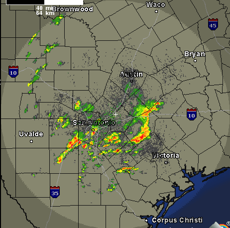
Severe Thunderstorm Warning
SEVERE THUNDERSTORM WARNING
TXC325-130245-
/O.NEW.KEWX.SV.W.0010.070313T0229Z-070313T0245Z/
BULLETIN - EAS ACTIVATION REQUESTED
SEVERE THUNDERSTORM WARNING
NATIONAL WEATHER SERVICE AUSTIN/SAN ANTONIO TX
929 PM CDT MON MAR 12 2007
THE NATIONAL WEATHER SERVICE IN AUSTIN SAN ANTONIO HAS ISSUED A
* SEVERE THUNDERSTORM WARNING FOR THE FOLLOWING COUNTIES...
MEDINA
* UNTIL 945 PM CDT
* AT 924 PM CDT...NATIONAL WEATHER SERVICE METEOROLOGISTS HAVE
DETECTED A SEVERE THUNDERSTORM CAPABLE OF PRODUCING PENNY SIZE
HAIL. THIS STORM WAS LOCATED 11 MILES SOUTHWEST OF CASTROVILLE...
OR ABOUT 10 MILES SOUTHEAST OF HONDO...AND MOVING NORTHEAST AT 20
MPH.
* THE SEVERE THUNDERSTORM WILL BE...
6 MILES WEST OF CASTROVILLE AND 7 MILES SOUTHWEST OF RIO MEDINA BY
945 PM CDT
LAT...LON 2925 9916 2917 9897 2942 9882 2950 9903
0 likes


-
ncupsscweather
- Category 1
- Posts: 321
- Age: 38
- Joined: Tue Jan 02, 2007 8:05 pm
- Location: Hickory,North Carolina
-
Extremeweatherguy
- Category 5
- Posts: 11095
- Joined: Mon Oct 10, 2005 8:13 pm
- Location: Florida
-
Extremeweatherguy
- Category 5
- Posts: 11095
- Joined: Mon Oct 10, 2005 8:13 pm
- Location: Florida
Extremeweatherguy wrote:
Doesn't look as impressive last night. However, you never know. Sometimes a quiet radar gives a way to an active one in the early morning hours. It happens. I think later today, tonight, and early Wednesday might be a big storm event. I remember several years ago, a cool front came by and the forecast did not call for any rain that night. Guess what? It did rain and there was thunder. SE Texas is unpredictable.
0 likes
Extremeweatherguy wrote:I think there is a good chance we will see more development tonight or tomorrow with a few strong storms possible tomorrow afternoon (may be even a few supercells here and there across the state). However, I think our most widespread threat for more heavy rain and severe weather is coming tomorrow night and especially Wednesday morning. If the 18Z GFS run is right, then we could be talking about something similar to or worse than what we saw this morning...JenBayles wrote:Hey Extreme! That's pretty much what it looked like under the Bear Creek Dome early this morning. Great storm, huh? :-D When do you think the next vort will move thru? I'm thinking about the same time again tonite/Tuesday morning. My gardens and I are lovin' it!
http://www.nco.ncep.noaa.gov/pmb/nwprod ... _036.shtml
^^Around midnight Wednesday morning. A strong MCS feature is developing to our west.^^
http://www.nco.ncep.noaa.gov/pmb/nwprod ... _042.shtml
^^Near sunrise Wednesday morning. The MCS looks to be hitting Houston hard at this time and it could even be worse than what we saw last night.^^
http://www.nco.ncep.noaa.gov/pmb/nwprod ... _048.shtml
^^Wednesday afternoon. The MCS moves off the coast and into SW Louisiana. This seems to be the end of our severe threat.^^
Going to be an interesting next 48 hours for sure..
Sure will be. Keep an eye on it.
0 likes
-
Extremeweatherguy
- Category 5
- Posts: 11095
- Joined: Mon Oct 10, 2005 8:13 pm
- Location: Florida
Latest SPC Day 1 outlook...

SE Texas is right in the heart of the threat area today and it seems like we could have a few different threats before it is all over. This morning and this afternoon we will probably see scattered strong storms and possibly a few supercells, and then tonight into tomorrow we could be looking at one or two MCS features in the area.
...SRN TO ERN TX/WRN LA...
SWLY MID LEVEL WINDS ARE EXPECTED TO STRENGTHEN FROM THE LOWER HALF
OF THE RIO GRANDE VALLEY NEWD INTO LOWER MS VALLEY AS SRN HIGH
PLAINS LOW MOVES EWD THIS FORECAST PERIOD. SLY LOW LEVEL WINDS WILL
CONTINUE TO PROVIDE AN INFLUX OF MOISTURE ACROSS MUCH OF THE SLIGHT
RISK AREA AND NEWD ALONG THE LOWER MS INTO LOWER OH RIVER VALLEYS.
SURFACE DEWPOINTS IN THE MID 60S ARE EXPECTED ALONG THE COASTAL
PLAIN OF TX INTO THE LOWER MS VALLEY.
MODELS SUGGEST FORCING FOR ASCENT SHOULD BE RATHER WEAK FROM SRN
INTO ERN TX DURING THE FIRST HALF OF THE PERIOD. HOWEVER...SURFACE
HEATING WITHIN A WEAKLY CAPPED MOIST AIR MASS AND COOLING MID LEVEL
TEMPERATURES ACROSS THIS REGION SUGGESTS AN EXTENSIVE COVERAGE OF
TSTM DEVELOPMENT FROM THIS MORNING INTO THE AFTERNOON. THE STRONGER
SWLY MID LEVEL WINDS ARE EXPECTED TO COMPENSATE FOR THE WEAKER LOW
LEVEL WINDS AND SUPPORT EFFECTIVE BULK SHEAR VALUES AROUND 40 KT FOR
ORGANIZED STRONG TO SEVERE STORMS. STRONGER ASCENT SPREADING EWD
ACROSS SERN/ERN TX TO WRN LA THIS EVENING/TONIGHT AND STRENGTHENING
SLY LLJ INTO ERN TX/LA SHOULD SUPPORT ADDITIONAL TSTMS WITH
POTENTIAL FOR UPSCALE GROWTH INTO ONE OR TWO MCS.
SE Texas is right in the heart of the threat area today and it seems like we could have a few different threats before it is all over. This morning and this afternoon we will probably see scattered strong storms and possibly a few supercells, and then tonight into tomorrow we could be looking at one or two MCS features in the area.
0 likes
Return to “USA & Caribbean Weather”
Who is online
Users browsing this forum: AnnularCane and 73 guests