SE TX/SW LA weather: Much cooler and WET after Tuesday
Moderator: S2k Moderators
Forum rules

The posts in this forum are NOT official forecast and should not be used as such. They are just the opinion of the poster and may or may not be backed by sound meteorological data. They are NOT endorsed by any professional institution or STORM2K.
-
vbhoutex

- Storm2k Executive

- Posts: 29149
- Age: 74
- Joined: Wed Oct 09, 2002 11:31 pm
- Location: Cypress, TX
- Contact:
Re: SE TX/SW LA weather: Severe Weather Possible
It's been very windy here for a few days as I am sure it has been in Frack's area. We had gusts measured to 34 mph today at the nearest weatherbug to me. No trees have come come down that I am aware of.
0 likes
-
southerngale

- Retired Staff

- Posts: 27418
- Joined: Thu Oct 10, 2002 1:27 am
- Location: Southeast Texas (Beaumont area)
Re:
CajunMama wrote:It's been windy in Frack's neck of the woods. A tree went down somewhere near her and she's been without power for a couple of hours. She said it's getting pretty toasty! She had a family member check with her utility company and that one tree affected 472 people.
Either you or I typed/texted it wrong, but it was actually 742. Not that it really matters...
It's been really windy today. We still have a Wind Advisory out.
I assume the saturated grounds didn't help matters, but the wind knocked down a big tree that fell on the main line into my suburban community and everyone here, as well as a few outside of the community, were without power from about 2pm until a little after 9:30. The tree and power line fell into Pine Island Bayou! (which is above flood stage) As the time for the Rockets tipoff got nearer and nearer, and the projected time for electricity to be restored went from 9pm to 11pm, we grabbed what we needed and went to my parent's house to watch the game and get some showers. It came back during the game. Rockets 3-1, baby!!
0 likes


-
srainhoutx

- S2K Supporter

- Posts: 6919
- Age: 68
- Joined: Sun Jan 14, 2007 11:34 am
- Location: Haywood County, NC
- Contact:
Re: SE TX/SW LA weather: Severe Weather Possible
Morning Update from Jeff Lindner...
Tornado Watch # 198 issued for the NW 1/3rd of SE TX until 100pm.
This watch includes the counties of: Brazos, Walker, Madison, Washington, and Burleson.
Discussion:
Vort max over the big bend of TX lifting ENE this morning across an unstable air mass. Result has been a rapid evolution of a large thunderstorm complex (MCS) over C TX from Dallas to N of Austin. Within the last hour the storms along and W of I-35 between Waco and Dallas have increased in intensity with the southern portion of the line NW of Austin showing a classic line echo wave pattern (LEWP) indicating a damaging wind threat. 88D out of Granger, TX shows tremendous low level inflow into this complex with 2,000 ft winds upwards of 45-50kts. Low level jet continues to pump copious amounts of Gulf moisture into the area feeding this complex.
Expect the MCS to move into our NW counties late this morning and then possibly progress across a large part of the area. If not, its associated outflow boundary will move deep into the area leading o new storm development this afternoon. Given shear values and expected very unstable air mass all severe modes will be possible.
Rainfall:
Main item of concern is that for additional excessive rainfall given now saturated grounds across a large part of the area and potential again for some quick high totals. For now forward motions look fast enough to preclude a significant flash flood threat however as the boundary moves into the area it may slow leading to more training and higher totals. Will have to watch radar trends closely. Best threat for heavy to excessive rains should be along and N of I-10 where best dynamics will be found and low level boundary will be present.
Extended:
Flood/flash flood event looks to focus over N TX this week as a frontal boundary stalls in that region. Sub-tropical ridge will gradually build northward from the Gulf and Mexico with cap intensity increasing over our area and this should make for warm, humid and windy conditions with a 20-30% chances of showers under the cap. Will keep a close eye on convective trends to our N and NW to make sure they do not send any rogue outflow boundaries our way that could touch off storms locally.
0 likes
-
srainhoutx
- S2K Supporter
- Posts: 6919
- Age: 68
- Joined: Sun Jan 14, 2007 11:34 am
- Location: Haywood County, NC
- Contact:
Re: SE TX/SW LA weather: Severe Weather Possible
HGX Update...
AREA FORECAST DISCUSSION
NATIONAL WEATHER SERVICE HOUSTON/GALVESTON TX
1057 AM CDT MON APR 27 2009
.DISCUSSION...
ANTICIPATING A BUSY DAY AHEAD FOR US AS THE REMNANTS OF THE MCS
HEADS THIS WAY. A VERY WEAK CAP OVER THE REGION ALONG WITH SOME
BREAKS IN THE CLOUDS...STRONG ONSHORE FLOW...FAVORABLE LOCATION
OF THE UPPER JET ALL COMBINING TO HELP INCREASE THE SEVERE TSRA
THREAT FOR THIS AFTN INTO THE EARLY EVENING FOR ALL OF SE TX.
IN ADDITION (GIVEN THE HVY RAINFALL OF LATE)...WILL ALSO BE ADD-
ING THE MENTION OF HVY RAINS TO THE WX GRIDS IN THE 1ST/2ND PDS.
AND IT STANDS RIGHT NOW IT PROBABLY WILL NOT TAKE ALL THAT MUCH
MORE TO CAUSE MORE PROBLEMS FOR SOME OF OUR WATERSHEDS. 41
0 likes

-
southerngale
- Retired Staff
- Posts: 27418
- Joined: Thu Oct 10, 2002 1:27 am
- Location: Southeast Texas (Beaumont area)
Re:
JenBayles wrote:Great. All I need is another flooding event....
Doesn't the Bear Creek Dome usually hold? Maybe it will return to its former glory and prevent a flooding event.
I was really busy this weekend and I'm not sure when the chance of rain/storms crept up, but I think it was yesterday morning when I saw rain chances only for Tuesday, then a bunch of 20% for the rest of the week. I'm almost positive today was sunny or partly cloudy. I guess the models were late to the ballgame on this one as well?
I just saw the radar... wow. And SPC has us in a slight risk (you too, Frick).
0 likes
-
JenBayles

- Category 5

- Posts: 3461
- Age: 63
- Joined: Tue Aug 26, 2003 3:27 pm
- Location: Houston, TX
- Contact:
Re: Re:
southerngale wrote:JenBayles wrote:Great. All I need is another flooding event....
Doesn't the Bear Creek Dome usually hold? Maybe it will return to its former glory and prevent a flooding event.
0 likes
-
JenBayles
- Category 5
- Posts: 3461
- Age: 63
- Joined: Tue Aug 26, 2003 3:27 pm
- Location: Houston, TX
- Contact:
Re: SE TX/SW LA weather: Severe Weather Possible
SHORT TERM FORECAST
NATIONAL WEATHER SERVICE HOUSTON/GALVESTON TX
106 PM CDT MON APR 27 2009
GMZ330-335-350-355-TXZ179-200-213-214-236>238-272015-
MATAGORDA BAY-GALVESTON BAY-
WATERS FROM FREEPORT TO THE MATAGORDA SHIP CHANNEL OUT 20 NM-
WATERS FROM HIGH ISLAND TO FREEPORT OUT 20 NM-POLK-LIBERTY-HARRIS-
CHAMBERS-MATAGORDA-BRAZORIA-GALVESTON-
INCLUDING THE CITIES OF...LIVINGSTON...CORRIGAN...ONALASKA...
LIBERTY...CLEVELAND...DAYTON...HOUSTON...PASADENA...KATY...
TOMBALL...HUMBLE...WINNIE...MONT BELVIEU...ANAHUAC...BAY CITY...
PALACIOS...PEARLAND...LAKE JACKSON...ALVIN...ANGLETON...
FREEPORT...LEAGUE CITY...TEXAS CITY...FRIENDSWOOD...GALVESTON
106 PM CDT MON APR 27 2009
.NOW...
THROUGH 4 PM...SCATTERED SHOWERS WILL BE DEVELOPING ALONG AND NEAR
THE COAST AND MOVING NORTHEAST THROUGH THE AREA. RAINFALL FROM
THESE SHOWERS WILL BE BRIEF AND ACCUMULATIONS SHOULD AVERAGE LESS
THAN ONE TENTH OF AN INCH. AFTER 3 PM...SHOWERS AND
THUNDERSTORMS...SOME WITH HEAVY RAIN AND GUSTY WINDS WILL MOVE
INTO THE AREA FROM THE NORTHWEST. RAINFALL RATES WITH THE STRONGER
STORMS MAY REACH 2 INCHES PER HOUR.
0 likes
-
srainhoutx
- S2K Supporter
- Posts: 6919
- Age: 68
- Joined: Sun Jan 14, 2007 11:34 am
- Location: Haywood County, NC
- Contact:
Re: SE TX/SW LA weather: Severe Weather Possible
LOCATION...S CENTRAL AND SE TEXAS...
.
ATTN WFOS...HGX...FWD...EWX...SJT...
ATTN RFCS...WGRFC...
.
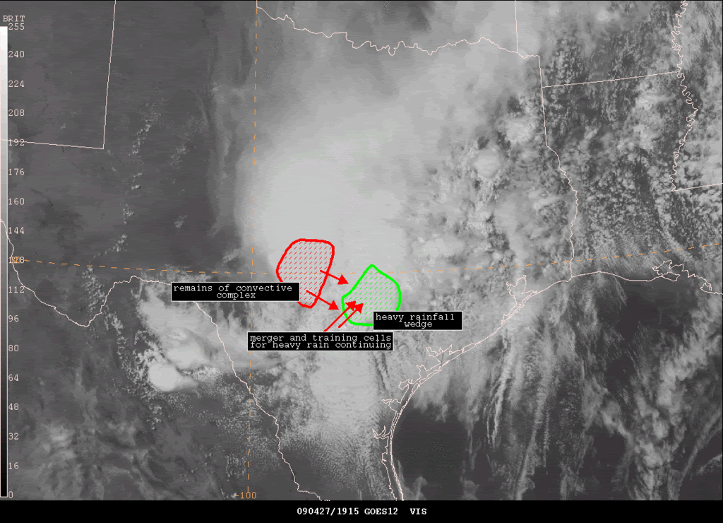
EVENT...CONVECTIVE COMPLEX MOVING EAST AND MAY TRAIN ACROSS WILSON TO
CALDWELL COUNTIES...COULD AFFECT SE TEXAS THIS EVENING...
.
SATELLITE ANALYSIS AND TRENDS...LARGE CONVECTIVE COMPLEX FROM THIS
MORNING HAS SPLIT INTO TWO WITH ONE WEAKENING AND MOVING NORTHEAST
INTO OKLAHOMA. WHILE OTHER COMPLEX HAS MOVED ACROSS CENTRAL TEXAS.
DEEP MOISTURE IN PLACE AND INCREASING AND INTERACTION WITH CONVECTIVE
COMPLEX WILL INCREASING TRAINING CELL AND HEAVY RAIN POTENTIAL FOR
COUNTIES OF WILSON TO GUADALUPE TO CALDWELL NEXT 1-3HRS.
FOR LATE THIS AFTERNOON AND EVENING.
WILL CONTINUE TO MONITOR...
SATELLITE ANALYSIS GRAPHIC WILL BE POSTED TO WEB ADDRESS BELOW IN 10
MINUTES..
Edit to add HGX Update...
.
ATTN WFOS...HGX...FWD...EWX...SJT...
ATTN RFCS...WGRFC...
.
EVENT...CONVECTIVE COMPLEX MOVING EAST AND MAY TRAIN ACROSS WILSON TO
CALDWELL COUNTIES...COULD AFFECT SE TEXAS THIS EVENING...
.
SATELLITE ANALYSIS AND TRENDS...LARGE CONVECTIVE COMPLEX FROM THIS
MORNING HAS SPLIT INTO TWO WITH ONE WEAKENING AND MOVING NORTHEAST
INTO OKLAHOMA. WHILE OTHER COMPLEX HAS MOVED ACROSS CENTRAL TEXAS.
DEEP MOISTURE IN PLACE AND INCREASING AND INTERACTION WITH CONVECTIVE
COMPLEX WILL INCREASING TRAINING CELL AND HEAVY RAIN POTENTIAL FOR
COUNTIES OF WILSON TO GUADALUPE TO CALDWELL NEXT 1-3HRS.
FOR LATE THIS AFTERNOON AND EVENING.
WILL CONTINUE TO MONITOR...
SATELLITE ANALYSIS GRAPHIC WILL BE POSTED TO WEB ADDRESS BELOW IN 10
MINUTES..
Edit to add HGX Update...
AREA FORECAST DISCUSSION
NATIONAL WEATHER SERVICE HOUSTON/GALVESTON TX
325 PM CDT MON APR 27 2009
.DISCUSSION...
EVENT STILL UNFOLDING ACROSS SE TX THIS AFTN AS THE MCS REMNANTS
MOVE INTO THE AREA. PER NESDIS...ANOTHER SLUG OF SLIGHTLY HIGHER
PWS (MOVING UP FROM THE LOWER/MID TX COAST) EXPECTED TO REACH US
SHORTLY. WHILE ITS VALUES (AOA 1.7") ARE A LOWER THAN WEEKS (AOA
2.1")...NOT SURE THAT IT WILL MAKE THAT MUCH OF A DIFFERENCE FOR
LOCATIONS THAT ARE STILL RECOVERING FROM THE LAST BATCHES OF HVY
RAIN. BUT GIVEN THE STRONG MESO FEATURES/FACTORS WILL BE ISSUING
THE FFA FOR ALL OF THE CWA TONIGHT AS THERE IS THERE IS A LOT OF
UNCERTAINTY CONCERNING WHERE THE BEST TRAINING WILL SET UP.
WILL BE KEEPING RAIN CHANCES IN THROUGH MID WEEK (AT LEAST) WITH
THE APPROACH/PASSAGE OF MORE SHORTWAVES FROM THE WEST (DESPITE A
FLATTENING UPPER FLOW). WE COULD GET ENOUGH RIDGING ALOFT BY FRI
AND SAT TO DECREASE POPS...BUT GOING BY THE EXTENDED RANGE PROGS
(ESP ECMWF) WE COULD SEE ANOTHER DECENT SHOT OF RAIN/STORMS SUN.
41
0 likes
-
srainhoutx
- S2K Supporter
- Posts: 6919
- Age: 68
- Joined: Sun Jan 14, 2007 11:34 am
- Location: Haywood County, NC
- Contact:
Re: SE TX/SW LA weather: Severe Weather Possible
Need to keep an eye on storm Wof Cuero. Just went warned for tornado...
BULLETIN - EAS ACTIVATION REQUESTED
TORNADO WARNING
NATIONAL WEATHER SERVICE AUSTIN/SAN ANTONIO TX
340 PM CDT MON APR 27 2009
THE NATIONAL WEATHER SERVICE IN AUSTIN SAN ANTONIO HAS ISSUED A
* TORNADO WARNING FOR...
NORTHERN DEWITT COUNTY...
EXTREME SOUTH CENTRAL GONZALES COUNTY...
EXTREME NORTHEASTERN KARNES COUNTY...
* UNTIL 430 PM CDT.
* AT 339 PM CDT...NWS METEOROLOGISTS HAVE DETECTED A SEVERE
THUNDERSTORM CAPABLE OF PRODUCING A TORNADO 6 MILES SOUTHWEST OF
WESTHOFF...OR ABOUT 11 MILES NORTH OF YORKTOWN...MOVING EAST AT 45
MPH.
* SOME LOCATIONS IN THE WARNING INCLUDE CUERO.
0 likes
-
srainhoutx
- S2K Supporter
- Posts: 6919
- Age: 68
- Joined: Sun Jan 14, 2007 11:34 am
- Location: Haywood County, NC
- Contact:
Re: SE TX/SW LA weather: Severe Weather Possible
FLOOD WATCH
NATIONAL WEATHER SERVICE HOUSTON/GALVESTON TX
347 PM CDT MON APR 27 2009
TXZ163-164-176>179-195>200-210>214-226-227-235>238-280500-
/O.NEW.KHGX.FA.A.0002.090427T2047Z-090428T0500Z/
/00000.0.ER.000000T0000Z.000000T0000Z.000000T0000Z.OO/
AUSTIN-BRAZORIA-BRAZOS-BURLESON-CHAMBERS-COLORADO-FORT BEND-
GALVESTON-GRIMES-HARRIS-HOUSTON-JACKSON-LIBERTY-MADISON-MATAGORDA-
MONTGOMERY-POLK-SAN JACINTO-TRINITY-WALKER-WALLER-WASHINGTON-
WHARTON-
INCLUDING THE CITIES OF...ALVIN...ANAHUAC...ANGLETON...BAY CITY...
BELLVILLE...BRENHAM...BROOKSHIRE...BRYAN...CALDWELL...CLEVELAND...
COLDSPRING...COLLEGE STATION...COLUMBUS...CONROE...CORRIGAN...
CROCKETT...DAYTON...EAGLE LAKE...EDNA...EL CAMPO...FREEPORT...
FRIENDSWOOD...GALVESTON...GROVETON...HEMPSTEAD...HOUSTON...
HUMBLE...HUNTSVILLE...KATY...LAKE JACKSON...LAKE SOMERVILLE...
LEAGUE CITY...LIBERTY...LIVINGSTON...MADISONVILLE...
MISSOURI CITY...MONT BELVIEU...NAVASOTA...ONALASKA...PALACIOS...
PASADENA...PEARLAND...PIERCE...PRAIRIE VIEW...RICHMOND...
ROSENBERG...SEALY...SHEPHERD...SUGAR LAND...TEXAS CITY...
THE WOODLANDS...TOMBALL...TRINITY...WEIMAR...WHARTON...WILLIS...
WINNIE
347 PM CDT MON APR 27 2009
...FLOOD WATCH IN EFFECT UNTIL MIDNIGHT CDT TONIGHT...
THE NATIONAL WEATHER SERVICE IN HOUSTON/GALVESTON HAS ISSUED A
* FLOOD WATCH FOR A PORTION OF SOUTHEAST TEXAS...INCLUDING THE
FOLLOWING COUNTIES...AUSTIN...BRAZORIA...BRAZOS...BURLESON...
CHAMBERS...COLORADO...FORT BEND...GALVESTON...GRIMES...
HARRIS...HOUSTON...JACKSON...LIBERTY...MADISON...MATAGORDA...
MONTGOMERY...POLK...SAN JACINTO...TRINITY...WALKER...WALLER...
WASHINGTON AND WHARTON.
* UNTIL MIDNIGHT CDT TONIGHT
* THE REMNANTS OF AN OVERNIGHT STORM COMPLEX WILL CONTINUE MOVING
INTO THE REGION DURING THE REMAINDER OF THIS AFTERNOON AND INTO
THE EVENING HOURS. ABUNDANT GULF MOISTURE COMBINED WITH
FAVORABLE WINDS ALOFT ARE EXPECTED TO PRODUCE STORMS WITH HEAVY
RAINFALL. RAIN TOTALS SHOULD AVERAGE FROM ONE HALF TO ONE INCH
AREAWIDE BUT SOME LOCATIONS COULD SEE ISOLATED AMOUNTS FROM 2 TO
4 INCHES.
* SOME PARTS OF SOUTHEAST TEXAS ARE STILL RECOVERING FROM HEAVY
RAINS FROM THIS PAST WEEKEND...PARTICULARLY LOCATIONS ALONG AND
SOUTH OF INTERSTATE TEN IN THE HOUSTON METRO AREA. THESE
ADDITIONAL RAINS COULD LEAD TO A SERIOUS THREAT OF FLASH FLOODING.
0 likes
-
Tampa Bay Hurricane

- Category 5
- Posts: 5597
- Age: 38
- Joined: Fri Jul 22, 2005 7:54 pm
- Location: St. Petersburg, FL
-
srainhoutx
- S2K Supporter
- Posts: 6919
- Age: 68
- Joined: Sun Jan 14, 2007 11:34 am
- Location: Haywood County, NC
- Contact:
Re: SE TX/SW LA weather: Severe Weather Possible
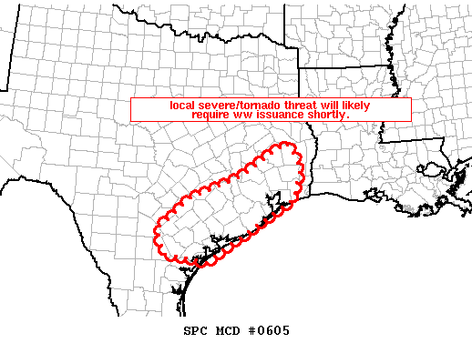
MESOSCALE DISCUSSION 0605
NWS STORM PREDICTION CENTER NORMAN OK
0350 PM CDT MON APR 27 2009
AREAS AFFECTED...MIDDLE AND UPPER TX COASTAL PLAIN
CONCERNING...SEVERE POTENTIAL...WATCH POSSIBLE
VALID 272050Z - 272215Z
INCREASE IN CONVECTION WILL LIKELY REQUIRE WW ISSUANCE ACROSS PARTS
OF THE TX COASTAL PLAIN SHORTLY.
LATEST RADAR IMAGERY DEPICTS AN INTENSE/WELL-ORGANIZED STORM OVER
GONZALES/DEWITT/KARNES COUNTIES ATTM...MOVING SLOWLY EWD. THIS
STORM IS OCCURRING WITHIN A VERY MOIST/MODERATELY-UNSTABLE
AIRMASS...NEAR AN OUTFLOW BOUNDARY ON THE SRN FRINGE OF THE REMNANTS
OF AN EARLIER CENTRAL TX MCS. LOW-LEVEL VEERING/SHEAR IS MAXIMIZED
INVOF THIS BOUNDARY...AND THUS EXPECT THIS STORM TO REMAIN
SUPERCELLULAR AS IT SHIFTS INTO THE TX COASTAL PLAIN. WITH THE
POTENTIAL FOR ADDITIONAL CONVECTIVE DEVELOPMENT INVOF THIS BOUNDARY
THIS AFTERNOON...AND GIVEN FAVORABLE THERMODYNAMICS AND PRONOUNCED
LOW-LEVEL VEERING IN THIS AREA...THREAT APPEARS TO WARRANT WW
ISSUANCE.
..GOSS.. 04/27/2009
ATTN...WFO...LCH...SHV...HGX...CRP...EWX...
0 likes
-
srainhoutx
- S2K Supporter
- Posts: 6919
- Age: 68
- Joined: Sun Jan 14, 2007 11:34 am
- Location: Haywood County, NC
- Contact:
Re:
Tampa Bay Hurricane wrote:That's an insane looking cell on the southernmost part of the line
just west of Victoria, Tx. Really intense bow/curvature.
EWX reports Tornado Damage near Yorktown.
0 likes
-
srainhoutx
- S2K Supporter
- Posts: 6919
- Age: 68
- Joined: Sun Jan 14, 2007 11:34 am
- Location: Haywood County, NC
- Contact:
Re: SE TX/SW LA weather: Severe Weather Possible
BULLETIN - EAS ACTIVATION REQUESTED
TORNADO WARNING
NATIONAL WEATHER SERVICE HOUSTON/GALVESTON TX
355 PM CDT MON APR 27 2009
THE NATIONAL WEATHER SERVICE IN LEAGUE CITY HAS ISSUED A
* TORNADO WARNING FOR...
NORTHWESTERN AUSTIN COUNTY IN SOUTHEAST TEXAS...
SOUTHERN WASHINGTON COUNTY IN SOUTHEAST TEXAS...
* UNTIL 430 PM CDT
* AT 353 PM CDT...NATIONAL WEATHER SERVICE DOPPLER RADAR INDICATED A
SEVERE THUNDERSTORM CAPABLE OF PRODUCING A TORNADO THIS TORNADO
WAS LOCATED NEAR SHELBY... MOVING NORTHEAST AT 25 MPH.
* LOCATIONS IN THE TORNADO WARNING INCLUDE BUT ARE NOT LIMITED TO NEW
ULM...INDUSTRY AND BRENHAM.
0 likes
Return to “USA & Caribbean Weather”
Who is online
Users browsing this forum: No registered users and 45 guests