Florida Weather
Moderator: S2k Moderators
Forum rules

The posts in this forum are NOT official forecast and should not be used as such. They are just the opinion of the poster and may or may not be backed by sound meteorological data. They are NOT endorsed by any professional institution or STORM2K.
-
Extremeweatherguy

- Category 5

- Posts: 11095
- Joined: Mon Oct 10, 2005 8:13 pm
- Location: Florida
Re:
Here is the CPC 6-10 Day Outlook released yesterday....looks like ridging setting up in the eastern half of the u.s.....wouldn't be conducive to much cold weather in florida in the short term (after the next few days)
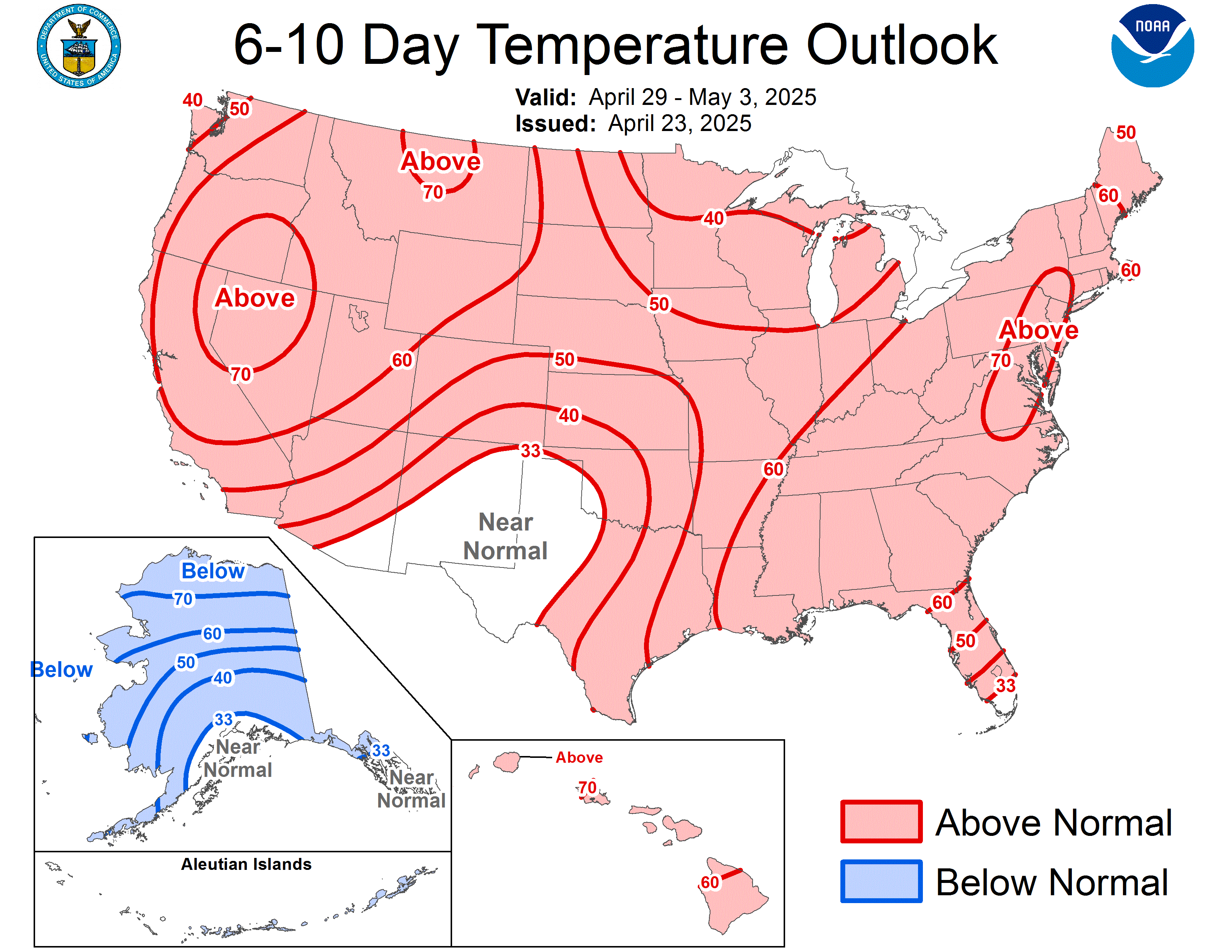
Extremeweatherguy wrote:I don't buy into the CPC seasonal forecasts anymore. They almost always call for above normal temperatures now days, and obviously that has not always played out. I do still enjoy the CPC's short-term outlooks though.
0 likes
-
Extremeweatherguy
- Category 5
- Posts: 11095
- Joined: Mon Oct 10, 2005 8:13 pm
- Location: Florida


-
gatorcane

- S2K Supporter

- Posts: 23708
- Age: 48
- Joined: Sun Mar 13, 2005 3:54 pm
- Location: Boca Raton, FL
Re: Florida Weather Thread: Coldest air of the season on the way
One thing that will be interesting to watch for Florida as the cold air moves in...
Looking at the WV loop/image, you can see a large area of high clouds in the Western Gulf of Mexico moving eastward. Should this cloud deck make it to Florida in time (and not fizzle which it may)...it would cap the temps from dropping so low across the FL peninsula...lows would average about 10 degrees warmer than projected currently.


Looking at the WV loop/image, you can see a large area of high clouds in the Western Gulf of Mexico moving eastward. Should this cloud deck make it to Florida in time (and not fizzle which it may)...it would cap the temps from dropping so low across the FL peninsula...lows would average about 10 degrees warmer than projected currently.
Last edited by gatorcane on Tue Oct 28, 2008 2:24 pm, edited 1 time in total.
0 likes
Re: Florida Weather Thread: Coldest air of the season on the way
My city is the first major florida reporting station to reach 70 today!
FLORIDA REGIONAL WEATHER ROUNDUP
300 PM EDT TUE OCT 28 2008
PENSACOLA SUNNY 58
PENSACOLA NAS SUNNY 59
MILTON NAS SUNNY 61
PANAMA CITY SUNNY 58
APALACHICOLA SUNNY 60
JACKSONVILLE MOSUNNY 61
ORLANDO INTL SUNNY 62
MELBOURNE SUNNY 65
VERO BEACH SUNNY 66
FT PIERCE SUNNY 65
CLEARWATER SUNNY 63
TAMPA MOSUNNY 63
SARASOTA SUNNY 62
PUNTA GORDA SUNNY 66
FT MYERS SUNNY 66
KEY WEST NAS MOSUNNY 68
FT LAUDERDALE SUNNY 70
POMPANO BEACH SUNNY 68
PEMBROKE PINES SUNNY 69
OPA LOCKA SUNNY 67
MIAMI MOSUNNY 68
0 likes
-
gatorcane
- S2K Supporter
- Posts: 23708
- Age: 48
- Joined: Sun Mar 13, 2005 3:54 pm
- Location: Boca Raton, FL
Hmmm..here is another view of the mid-upper level moisture streaming in from the western Gulf of Mexico. You can also notice slightly more moist air mixing out at the mid-levels across the Central GOM and points west.
I think its possible actual low temps across the FL peninsula (South Florida and maybe Central Florida) may be warmer than projected. More than likely these clouds would cross through South Florida or maybe as far as north as Central FL looking at mid and upper-level steering.

I think its possible actual low temps across the FL peninsula (South Florida and maybe Central Florida) may be warmer than projected. More than likely these clouds would cross through South Florida or maybe as far as north as Central FL looking at mid and upper-level steering.
0 likes
-
gatorcane
- S2K Supporter
- Posts: 23708
- Age: 48
- Joined: Sun Mar 13, 2005 3:54 pm
- Location: Boca Raton, FL
some humor out of NWS Miami (snippet below). Also record lows table below
...UNSEASONABLY COLD NIGHT AHEAD WITH SOME RECORD LOW`S LIKELY...
.DISCUSSION...COLD HIGH PRESSURE OVER THE LOWER MISSISSIPPI VALLEY
REGION WILL RIDGE FURTHER INTO THE AREA TONIGHT. MEANWHILE...THE
STRONG LOW OVER NEW ENGLAND WILL QUICKLY MOVE TO THE NORTH. THE
MOVEMENT OF THESE FEATURES WILL LEAD TO A GRADUAL RELAXATION OF
THE WINDS ACROSS THE AREA TONIGHT...SETTING THE STAGE FOR AN
UNSEASONABLY COLD NIGHT WITH RECORD LOW LIKELY AT SOME LOCALES.
SEE CLIMATE SECTION BELOW. MIN T`S TONIGHT WILL RANGE FROM THE
UPPER 30S OVER WESTERN GLADES/HENDRY COUNTIES TO THE LOWER 50S FAR
SE ATLANTIC COAST. EVEN HAD TO CONSIDER THE POSSIBILITY OF PATCHY
FROST OVER OUR GLADES/HENDRY COUNTIES AS DAYTIME TEMPS HAVE BEEN
RUNNING A FEW DEGREES BELOW GUIDANCE AND MOS IS GIVING AS LOW AS
37 IN GLADES COUNTY. NAM-WRF SHOWS UPPER 30S...WITH EVEN MID 30S
JUST WEST OF THE AREA OVER DESOTO COUNTY. HOWEVER...GIVEN THE
VERY BORDERLINE TEMPS...AND THE FACT THAT IT JUST COULD BE TOO
DRY IF DEWPOINTS DON`T RECOVER (B/C CURRENT DEWPOINTS ARE IN THE
20S/LOW 30S)...DECIDED NOT TO MENTION FROST IN COLLABORATION WITH
SURROUNDING OFFICES. EVENING SHIFT CAN KEEP A CLOSE EYE ON
TEMP/DEWPOINT TRENDS. IS THIS JANUARY?!
.CLIMATE...RECORD LOW`S ARE LIKELY AT SOME LOCALES OVERNIGHT. HERE
ARE SOME OF THE RECORD`S THAT ARE IN JEOPARDY:
SITE RECORD/YEAR
BELLE GLADE 42/1944
CANAL POINT 53/1958
CLEWISTON 53/2001
DEVILS GARDEN 50/2001
EVERGLADES CITY 50/1944
FLAMINGO 56/1972
IMMOKALEE 49/1987
LA BELLE 47/1957
MIAMI BEACH 58/1943
MOORE HAVEN 40/1938*
NAPLES 51/1943
PBI/W PALM BCH 51/1944
*DENOTES ALL-TIME MONTHLY RECORD
HERE ARE OTHER RECORD`S...BUT NOT LIKELY TO BE REACHED:
MIAMI...45/1938
FORT LAUDERDALE...46/1937
http://www.srh.noaa.gov/fwd/productview ... &version=0
0 likes
-
Extremeweatherguy
- Category 5
- Posts: 11095
- Joined: Mon Oct 10, 2005 8:13 pm
- Location: Florida
Here is a look at the high temperatures reported across the state so far today...
Tallahasee: 58F
Jacksonville: 58F
Ocala: 63F
Orlando: 63F
Tampa: 63F
Naples: 66F
Miami: 68F
Key West: 69F
I still find it very hard to believe that this is happening in OCTOBER!!! This kind of weather is more typical of January!
Tallahasee: 58F
Jacksonville: 58F
Ocala: 63F
Orlando: 63F
Tampa: 63F
Naples: 66F
Miami: 68F
Key West: 69F
I still find it very hard to believe that this is happening in OCTOBER!!! This kind of weather is more typical of January!
0 likes
-
tropicana

- Category 5
- Posts: 8056
- Joined: Sat Sep 27, 2003 6:48 pm
- Location: Niagara Falls, Ontario, Canada
- Contact:
Re: Florida Weather Thread: Coldest air of the season on the way
RECORD LOW MAXIMUMS today, Tue Oct 28 2008
IN FLORIDA
Jacksonville FL 59F
Gainesville FL 60F
Daytona Beach FL 63F
St Petersburg FL 63F
Sarasota FL 64F
Tampa FL 64F
Orlando FL 64F
Melbourne FL 66F
Ft Myers FL 67F
Vero Beach FL 67F
West Palm Beach FL 67F **OCTOBER RECORD**
Naples FL 69F **OCTOBER RECORD**
Ft Lauderdale FL 71F
Miami FL 71F
ELSEWHERE
Bluefield WV 37F
Jackson KY 42F
Huntsville AL 52F tied 1910
North Little Rock AR 53F
Columbia SC 54F tied 1976
-justin-
Last edited by tropicana on Wed Oct 29, 2008 10:40 am, edited 3 times in total.
0 likes
Re: Florida Weather Thread: Coldest air of the season on the way
Think it has never been this cold in Florida in October? Think again....we just have to go back 3 years to see an almost identical cold snap....
October 2005 featured a very strong cold front.....in fact, on 10/25/05 the high temp in Fort Lauderdale was only 69 degrees...even cooler than today's high of 71 deg.
The following were the high and low temps before and after the front:
October 24, 2005
Daytona Beach 77/55
Orlando 74/56
Melbourne 81/56
Fort Pierce 83/57
Fort Lauderdale 83/68
Miami 83/66
Front passes through...
October 25, 2005
Daytona Beach 63/47 (vs. 63/46 today)
Orlando 65/49 (vs. 64/47 today)
Melbourne 65/49 (vs. 66/48 today)
Fort Lauderdale 69/54 (vs. 71/56 today)
Miami 71/58...temp hit 56 on 10/26/05 (vs. 71/57 today)
temps moderated starting on the 26th
(data from NWS Miami & NWS Melbourne Climate Data)
Last edited by jinftl on Tue Oct 28, 2008 7:02 pm, edited 2 times in total.
0 likes
-
JonathanBelles
- Professional-Met

- Posts: 11430
- Age: 35
- Joined: Sat Dec 24, 2005 9:00 pm
- Location: School: Florida State University (Tallahassee, FL) Home: St. Petersburg, Florida
- Contact:
-
Extremeweatherguy
- Category 5
- Posts: 11095
- Joined: Mon Oct 10, 2005 8:13 pm
- Location: Florida
Re: Florida Weather Thread: Coldest air of the season on the way
The overall low temperatures will be colder with this event though. Orlando will get down to 43F tonight and Miami will reach 52F. So while the events are similar, this one is colder overall. The lows tonight will be the coldest October readings seen since October 1989 across most of the state.jinftl wrote:Think it has never been this cold in Florida in October? Think again....we just have to go back 3 years to see an almost identical cold snap....
October 2005 featured a very strong cold front.....in fact, on 10/25/05 the high temp in Fort Lauderdale was only 69 degrees...even cooler than today's high of 71 deg.
The following were the high and low temps before and after the front:
October 24, 2005
Daytona Beach 77/55
Orlando 74/56
Melbourne 81/56
Fort Pierce 83/57
Fort Lauderdale 83/68
Miami 83/66
Front passes through...
October 25, 2005
Daytona Beach 63/47 (vs. 63/46 today)
Orlando 65/49 (vs. 64/47 today)
Melbourne 65/49 (vs. 66/48 today)
Fort Lauderdale 69/54 (vs. 71/56 today)
Miami 71/58 (vs. 71/57 today)
temps moderated starting on the 26th
(data from NWS Miami & NWS Melbourne Climate Data)
0 likes
Re: Florida Weather Thread: Coldest air of the season on the way
True, but no questioning that the cold spells were similar in that they brought an abrupt end to October warmth and while there may be some differences in temps (within a handful of degrees in most case)....both cold snaps were 'shocking' to floridians and featured something unusual for october...temps down in the 30s and 40s north of Lake O and in the 50s south of the Lake.
Some of the lowest temps of the Oct 2005 cold snap....
Jacksonville 42
Gainesville 38
Tallahassee 33
Lakeland 46
Tamps 47
Daytona Beach 47
Orlando 49
Melbourne 49
Fort Myers 53
Sarasota 51
Fort Lauderdale 54
Miami 56
FYI, following the cold snap in October 2005, November 2005 averaged warmer than normal across the peninsula (Nov 2005 temp departures from normal: Jacksonville - +2.0, Gainesville - +1.1, Daytona Beach -+1.1, Orlando - +0.3, Tampa - +1.1, Sarasota +2.1, Miami - +1.1).
0 likes
-
Ed Mahmoud
Re: Florida Weather Thread: Coldest air of the season on the way
I remember, ballpark Christmas 1983, icicles on the palm trees at NTC Orlando, 32813 from the automatic sprinklers.
A lot of palms looked damaged after that, but most recovered. I remember a hard frost in March 1984 when I was there as well. I was amazed at how interior Florida could occasionally have almost (not quite) Texas style four season weather.
A lot of palms looked damaged after that, but most recovered. I remember a hard frost in March 1984 when I was there as well. I was amazed at how interior Florida could occasionally have almost (not quite) Texas style four season weather.
0 likes
Re: Florida Weather Thread: Coldest air of the season on the way
Looking at the monthly data from the Florida Climate Center (links below), the extreme cold in florida during 1989 was really a result of one extrememly cold month....December 1989.
Overall, the surrounding months were average to above average in temperature.....that doesn't mean there were not cold fronts, but overall, the only significantly below normal month of the infamous winter of 1989 in florida was December.
January 1990 was one of the warmest January's on record in florida...talk about a reversal!
Jacksonville
Avg. Temp Departure from Normal (deg)
Oct-89 70.6 (+0.1)
Nov-89 62.4 (+0.5)
Dec-89 47.7 (-7.6)
Jan-90 58.3 (+4.4)
http://www.sercc.com/cgi-bin/sercc/cliMAIN.pl?fl4358
Orlando
Avg. Temp Departure from Normal (deg)
Oct-89 75.2 (+0.0)
Nov-89 68.9 (+0.5)
Dec-89 55.5 (-7.1)
Jan-90 65.8 (+5.8)
http://www.sercc.com/cgi-bin/sercc/cliMAIN.pl?fl6628
Miami
Avg. Temp Departure from Normal (deg)
Oct-89 79.0 (+0.3)
Nov-89 76.2 (+1.3)
Dec-89 64.5 (-4.5)
Jan-90 73.4 (+5.8)
http://www.sercc.com/cgi-bin/sercc/cliMAIN.pl?fl5663
0 likes
-
MiamiensisWx
Re: Florida Weather Thread: Coldest air of the season on the way
The October 24, 2005 frontal passage was associated with the shortwave trough that contributed to Wilma's recurvature across southern Florida... the overnight lows on October 25 represented one of the coldest October events I have witnessed in southern Florida. The remarkably vivid manifestation of the Milky Way (and thousands of stars) in a dark post-Wilma world was certainly extremely memorable. Interestingly, this event was one of the coldest frontal passages of the 2005-2006 winter in south Florida; in fact, the vast majority of the subsequent events did not yield lows as frigid as the October event, and the mean winter temperatures were generally above average in south Florida.
The general evolution of longwave patterns occasionally lends credence to the hypothesis that early frigid passages precede a warmer December/January/February/March (depending on the timing), especially in the current -PDO/+AMO regime. I believe previous climatological data indicates the Southeast ridge is more prominent during -PDO/+AMO regimes, and the angle of the cold air advection is not as favorable for widespread, severe, and persistent cold outbreaks in southeastern Florida. That fact would certainly partially explain the warmer winters and lack of more severe cold snaps on the southern peninsula in recent (post-2000) years. The general oceanic/atmospheric patterns varied considerably (from recent years) in the 1970s through the 1990s, which is consistent with the greater frequency of severe cold events in south Florida during the period.
The general evolution of longwave patterns occasionally lends credence to the hypothesis that early frigid passages precede a warmer December/January/February/March (depending on the timing), especially in the current -PDO/+AMO regime. I believe previous climatological data indicates the Southeast ridge is more prominent during -PDO/+AMO regimes, and the angle of the cold air advection is not as favorable for widespread, severe, and persistent cold outbreaks in southeastern Florida. That fact would certainly partially explain the warmer winters and lack of more severe cold snaps on the southern peninsula in recent (post-2000) years. The general oceanic/atmospheric patterns varied considerably (from recent years) in the 1970s through the 1990s, which is consistent with the greater frequency of severe cold events in south Florida during the period.
0 likes
-
gatorcane
- S2K Supporter
- Posts: 23708
- Age: 48
- Joined: Sun Mar 13, 2005 3:54 pm
- Location: Boca Raton, FL
Re: Florida Weather Thread: Coldest air of the season on the way
This WV image shows the mid and high-level moisture/cloud deck now in the Central GOM heading towards South Florida as I explained earlier in this thread. If it gets here within about 7 hours or so, it could keep the temperatures from dipping as low as was forecasted today. In fact if it made it the temps would probably warm up a few degrees overnight across Southern Florida.
Loop it here:
http://www.ssd.noaa.gov/goes/east/gmex/loop-wv.html
Loop it here:
http://www.ssd.noaa.gov/goes/east/gmex/loop-wv.html
0 likes
Re: Florida Weather Thread: Coldest air of the season on the way
Kudos for making the Wilma connection to October 2005's cold blast....was waiting to see if anyone caught that! Truly a remarkable few days of weather that was.
So if I am understanding, there may be some correlation between early cold waves followed by warmer than average winter months with less frequent and severe cold outbreaks in south fla? Speaking 'on average' of course.
So if I am understanding, there may be some correlation between early cold waves followed by warmer than average winter months with less frequent and severe cold outbreaks in south fla? Speaking 'on average' of course.
MiamiensisWx wrote:The October 24, 2005 frontal passage was associated with the shortwave trough that contributed to Wilma's recurvature across southern Florida... the overnight lows on October 25 represented one of the coldest October events I have witnessed in southern Florida. The remarkably vivid manifestation of the Milky Way (and thousands of stars) in a dark post-Wilma world was certainly extremely memorable. Interestingly, this event was one of the coldest frontal passages of the 2005-2006 winter in south Florida; in fact, the vast majority of the subsequent events did not yield lows as frigid as the October event, and the mean winter temperatures were generally above average in south Florida.
The general evolution of longwave patterns occasionally lends credence to the hypothesis that early frigid passages precede a warmer December/January/February/March (depending on the timing), especially in the current -PDO/+AMO regime. I believe previous climatological data indicates the Southeast ridge is more prominent during -PDO/+AMO regimes, and the angle of the cold air advection is not as favorable for widespread, severe, and persistent cold outbreaks in southeastern Florida. That fact would certainly partially explain the warmer winters and lack of more severe cold snaps on the southern peninsula in recent (post-2000) years.
0 likes
Return to “USA & Caribbean Weather”
Who is online
Users browsing this forum: Stratton23 and 33 guests