Next round of severe weather 7th May Onwards?

U.S. & Caribbean Weather Discussions and Severe Weather Events

Moderator: S2k Moderators

Forum rules

The posts in this forum are NOT official forecast and should not be used as such. They are just the opinion of the poster and may or may not be backed by sound meteorological data. They are NOT endorsed by any professional institution or STORM2K.

Help Support Storm2K
Message
Author
CrazyC83
Professional-Met
Professional-Met
Posts: 34001
Joined: Tue Mar 07, 2006 11:57 pm
Location: Deep South, for the first time!

Re:

#281 Postby CrazyC83 » Mon May 10, 2010 4:59 pm

brunota2003 wrote:Wow...a tornado moving into the OKC area, and another moving towards Wichita...unreal.


This is May 3, 1999 all over again it appears...
0 likes   

apocalypt-flyer
Category 1
Category 1
Posts: 468
Joined: Sat Aug 27, 2005 11:51 am

#282 Postby apocalypt-flyer » Mon May 10, 2010 4:59 pm

Talk about all hell breaking loose at the moment.
0 likes   

mcallum177
Tropical Depression
Tropical Depression
Posts: 98
Joined: Sun Jun 14, 2009 12:39 am
Location: Dallas, TX

#283 Postby mcallum177 » Mon May 10, 2010 4:59 pm

Can someone explain why the tornado has such a long hook/trunk near Wichita?
0 likes   

CrazyC83
Professional-Met
Professional-Met
Posts: 34001
Joined: Tue Mar 07, 2006 11:57 pm
Location: Deep South, for the first time!

#284 Postby CrazyC83 » Mon May 10, 2010 4:59 pm

NWS Wichita should issue a Tornado Emergency on the next update for Wichita.
0 likes   

User avatar
Dave
Retired Staff
Retired Staff
Posts: 13442
Age: 74
Joined: Tue Aug 01, 2006 3:57 pm
Location: Milan Indiana
Contact:

#285 Postby Dave » Mon May 10, 2010 5:01 pm

Image
0 likes   

User avatar
Bunkertor
Category 5
Category 5
Posts: 3397
Joined: Tue May 09, 2006 3:48 pm

Re:

#286 Postby Bunkertor » Mon May 10, 2010 5:02 pm

CrazyC83 wrote:NWS Wichita should issue a Tornado Emergency on the next update for Wichita.


Hmmmm, i´d agree.
0 likes   

User avatar
Dave
Retired Staff
Retired Staff
Posts: 13442
Age: 74
Joined: Tue Aug 01, 2006 3:57 pm
Location: Milan Indiana
Contact:

#287 Postby Dave » Mon May 10, 2010 5:02 pm

SEDGWICK KS-
501 PM CDT MON MAY 10 2010

...A TORNADO WARNING REMAINS IN EFFECT FOR CENTRAL SEDGWICK COUNTY
UNTIL 530 PM CDT...

AT 458 PM CDT...TRAINED WEATHER SPOTTERS REPORTED A TORNADO ON THE
GROUND 6 MILES NORTH OF VIOLA. THIS TORNADO WAS LOCATED 5 MILES
SOUTH OF GODDARD...OR 16 MILES SOUTHWEST OF DOWNTOWN
WICHITA...MOVING EAST AT 50 MPH.


LOCATIONS IMPACTED INCLUDE...
DOWNTOWN WICHITA...GODDARD...WEST WICHITA...WICHITA MID CONTINENT
AIRPORT...HAYSVILLE...SOUTH WICHITA...DERBY...MCCONNELL AIR FORCE
BASE...PARK CITY...EAST WICHITA...NORTHEAST WICHITA...OAKLAWN...BEL
AIRE...KECHI AND JABARA AIRPORT.

PRECAUTIONARY/PREPAREDNESS ACTIONS...

TO REPEAT...A TORNADO IS ON THE GROUND. TAKE COVER NOW. MOVE TO AN
INTERIOR ROOM ON THE LOWEST FLOOR OF A STURDY BUILDING. AVOID
WINDOWS. IF IN A MOBILE HOME...A VEHICLE OR OUTDOORS...MOVE TO THE
CLOSEST SUBSTANTIAL SHELTER AND PROTECT YOURSELF FROM FLYING DEBRIS.
Last edited by Dave on Mon May 10, 2010 5:03 pm, edited 2 times in total.
0 likes   

User avatar
Bunkertor
Category 5
Category 5
Posts: 3397
Joined: Tue May 09, 2006 3:48 pm

Re: Next round of severe weather 7th May Onwards?

#288 Postby Bunkertor » Mon May 10, 2010 5:04 pm

340
WFUS54 KOUN 102157
TOROUN
OKC103-102230-
/O.NEW.KOUN.TO.W.0009.100510T2157Z-100510T2230Z/

BULLETIN - EAS ACTIVATION REQUESTED
TORNADO WARNING
NATIONAL WEATHER SERVICE NORMAN OK
457 PM CDT MON MAY 10 2010

THE NATIONAL WEATHER SERVICE IN NORMAN HAS ISSUED A

* TORNADO WARNING FOR...
NORTHEASTERN NOBLE COUNTY IN NORTHERN OKLAHOMA...

* UNTIL 530 PM CDT

* AT 457 PM CDT...RADAR AND STORM SPOTTERS OBSERVED A TORNADO 1 MILE
NORTH-NORTHEAST OF RED ROCK...MOVING EAST AT 55 MPH.

* LOCATIONS IN THE WARNING INCLUDE MARLAND...RED ROCK AND SOONER
LAKE.

PRECAUTIONARY/PREPAREDNESS ACTIONS...
0 likes   

User avatar
Dave
Retired Staff
Retired Staff
Posts: 13442
Age: 74
Joined: Tue Aug 01, 2006 3:57 pm
Location: Milan Indiana
Contact:

#289 Postby Dave » Mon May 10, 2010 5:04 pm

CANADIAN OK-OKLAHOMA OK-CLEVELAND OK-GRADY OK-
458 PM CDT MON MAY 10 2010

...A TORNADO WARNING REMAINS IN EFFECT UNTIL 545 PM CDT FOR
NORTHEASTERN GRADY...NORTHWESTERN CLEVELAND...OKLAHOMA AND
SOUTHEASTERN CANADIAN COUNTIES...

AT 457 PM CDT...NATIONAL WEATHER SERVICE RADAR DETECTED A SEVERE
THUNDERSTORM CAPABLE OF PRODUCING A TORNADO OVER EXTREME SOUTHWESTERN
OKLAHOMA CITY...6 MILES WEST OF MUSTANG...MOVING NORTHEAST AT 50
MPH. ANOTHER TORNADIC STORM WAS LOCATED NEAR YUKON.

* LOCATIONS IN THE WARNING INCLUDE ARCADIA...BETHANY...CHOCTAW...DEL
CITY...EDMOND...FOREST PARK...HARRAH...JONES...LAKE ALUMA...
LUTHER...MIDWEST CITY...MOORE...MUSTANG...NEWALLA...NICHOLS
HILLS...NICOMA PARK...OKLAHOMA CITY...SPENCER...THE VILLAGE...
TINKER AIR FORCE BASE...TUTTLE...VALLEY BROOK...WARR ACRES AND
YUKON.

THIS INCLUDES INTERSTATE 35 BETWEEN MILE MARKERS 117 AND 146.

THIS INCLUDES INTERSTATE 40 BETWEEN MILE MARKERS 127 AND 171.

THIS INCLUDES INTERSTATE 44 BETWEEN MILE MARKERS 109 AND 152.

PRECAUTIONARY/PREPAREDNESS ACTIONS...

IN ADDITION TO A TORNADO THREAT... THIS STORM LIKELY CONTAINS
DAMAGING HAIL TO THE SIZE OF BASEBALLS OR LARGER.
0 likes   

CrazyC83
Professional-Met
Professional-Met
Posts: 34001
Joined: Tue Mar 07, 2006 11:57 pm
Location: Deep South, for the first time!

#290 Postby CrazyC83 » Mon May 10, 2010 5:04 pm

At the current rate, that tornado hits suburbs in about 5 minutes and downtown in about 20 minutes. Definitely should be a Tornado Emergency there.
0 likes   

User avatar
Texas Snowman
Storm2k Moderator
Storm2k Moderator
Posts: 6151
Joined: Fri Jan 25, 2008 11:29 am
Location: Denison, Texas

Re: Re:

#291 Postby Texas Snowman » Mon May 10, 2010 5:05 pm

CrazyC83 wrote:
brunota2003 wrote:Wow...a tornado moving into the OKC area, and another moving towards Wichita...unreal.


This is May 3, 1999 all over again it appears...


Certainly starting to look that way.

I'm just hoping the cap holds here in N Texas...these cells are going tornadic quickly when they do develop.
0 likes   
The above post and any post by Texas Snowman is NOT an official forecast and should not be used as such. It is just the opinion of the poster and may or may not be backed by sound meteorological data. It is NOT endorsed by any professional institution including storm2k.org. For official information, please refer to NWS products.

User avatar
Dave
Retired Staff
Retired Staff
Posts: 13442
Age: 74
Joined: Tue Aug 01, 2006 3:57 pm
Location: Milan Indiana
Contact:

#292 Postby Dave » Mon May 10, 2010 5:05 pm

MAY 10 175800 EDT
TORNADO
8 MI N VIOLA
SEDGWICK CTY
KS
AMATEUR RADIO
TORNADO ON THE GROUND WITH 80 MPH WINDS AT SPOTTERS LOCATION
0 likes   

CrazyC83
Professional-Met
Professional-Met
Posts: 34001
Joined: Tue Mar 07, 2006 11:57 pm
Location: Deep South, for the first time!

#293 Postby CrazyC83 » Mon May 10, 2010 5:07 pm

http://www.ksn.com/content/weather/liveradar.aspx

Coverage from Wichita - KSN who was legendary in the Greensburg tornado. That tornado has suburbs in plain sight now.
0 likes   

CrazyC83
Professional-Met
Professional-Met
Posts: 34001
Joined: Tue Mar 07, 2006 11:57 pm
Location: Deep South, for the first time!

#294 Postby CrazyC83 » Mon May 10, 2010 5:08 pm

Tornado in sight from the Wichita Mid-Continent Airport.
0 likes   

User avatar
Dave
Retired Staff
Retired Staff
Posts: 13442
Age: 74
Joined: Tue Aug 01, 2006 3:57 pm
Location: Milan Indiana
Contact:

#295 Postby Dave » Mon May 10, 2010 5:09 pm

SEDGWICK KS-
508 PM CDT MON MAY 10 2010

...A TORNADO WARNING REMAINS IN EFFECT FOR CENTRAL SEDGWICK COUNTY
UNTIL 530 PM CDT...

AT 503 PM CDT...NATIONAL WEATHER SERVICE METEOROLOGISTS WERE TRACKING
A SEVERE THUNDERSTORM CAPABLE OF PRODUCING A TORNADO. THIS DANGEROUS
STORM WAS LOCATED NEAR GODDARD...OR 13 MILES SOUTHWEST OF DOWNTOWN
WICHITA...MOVING EAST AT 45 MPH.

LOCATIONS IMPACTED INCLUDE...
DOWNTOWN WICHITA...WEST WICHITA...WICHITA MID CONTINENT AIRPORT...
HAYSVILLE...SOUTH WICHITA...DERBY...MCCONNELL AIR FORCE BASE...PARK
CITY...EAST WICHITA...NORTHEAST WICHITA...OAKLAWN...BEL AIRE...
KECHI AND JABARA AIRPORT.

PRECAUTIONARY/PREPAREDNESS ACTIONS...

TAKE COVER NOW. MOVE TO AN INTERIOR ROOM ON THE LOWEST FLOOR OF A
STURDY BUILDING. AVOID WINDOWS. IF IN A MOBILE HOME...A VEHICLE OR
OUTDOORS...MOVE TO THE CLOSEST SUBSTANTIAL SHELTER AND PROTECT
YOURSELF FROM FLYING DEBRIS.
0 likes   

CrazyC83
Professional-Met
Professional-Met
Posts: 34001
Joined: Tue Mar 07, 2006 11:57 pm
Location: Deep South, for the first time!

#296 Postby CrazyC83 » Mon May 10, 2010 5:10 pm

Downtown Wichita would get that tornado around 5:35 pm if current trends continue. It is now in suburban areas.
0 likes   

User avatar
Dave
Retired Staff
Retired Staff
Posts: 13442
Age: 74
Joined: Tue Aug 01, 2006 3:57 pm
Location: Milan Indiana
Contact:

#297 Postby Dave » Mon May 10, 2010 5:12 pm

Image
0 likes   

CrazyC83
Professional-Met
Professional-Met
Posts: 34001
Joined: Tue Mar 07, 2006 11:57 pm
Location: Deep South, for the first time!

#298 Postby CrazyC83 » Mon May 10, 2010 5:13 pm

OKC: News 9 Tower Cam showing a tornado near Kilpatrick Turnkpike and north May.
0 likes   

User avatar
Texas Snowman
Storm2k Moderator
Storm2k Moderator
Posts: 6151
Joined: Fri Jan 25, 2008 11:29 am
Location: Denison, Texas

Re:

#299 Postby Texas Snowman » Mon May 10, 2010 5:13 pm

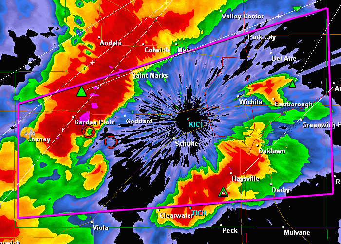
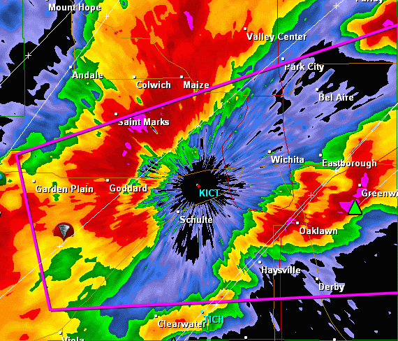
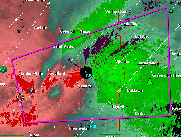
CrazyC83 wrote:Tornado in sight from the Wichita Mid-Continent Airport.


Not often you get an official observation of a tornado in sight...
0 likes   
The above post and any post by Texas Snowman is NOT an official forecast and should not be used as such. It is just the opinion of the poster and may or may not be backed by sound meteorological data. It is NOT endorsed by any professional institution including storm2k.org. For official information, please refer to NWS products.

User avatar
Dave
Retired Staff
Retired Staff
Posts: 13442
Age: 74
Joined: Tue Aug 01, 2006 3:57 pm
Location: Milan Indiana
Contact:

#300 Postby Dave » Mon May 10, 2010 5:13 pm

SRV

Image
0 likes   


Return to “USA & Caribbean Weather”

Who is online

Users browsing this forum: TomballEd and 59 guests