Texas Fall 2017

U.S. & Caribbean Weather Discussions and Severe Weather Events

Moderator: S2k Moderators

Forum rules

The posts in this forum are NOT official forecast and should not be used as such. They are just the opinion of the poster and may or may not be backed by sound meteorological data. They are NOT endorsed by any professional institution or STORM2K.

Help Support Storm2K
Message
Author
Ntxw
Storm2k Moderator
Storm2k Moderator
Posts: 21565
Joined: Wed Oct 21, 2009 6:34 pm
Location: DFW, Texas

Re: Texas Fall 2017

#281 Postby Ntxw » Fri Sep 29, 2017 6:14 pm

JDawg512 wrote:Doesn't look as hot for this area of the state next week as what is forecast up north. After a short break tomorrow and Sunday, rain chances return Monday.

It's been cloudy for 6 days straight. Pretty impressive streak for this time of year.


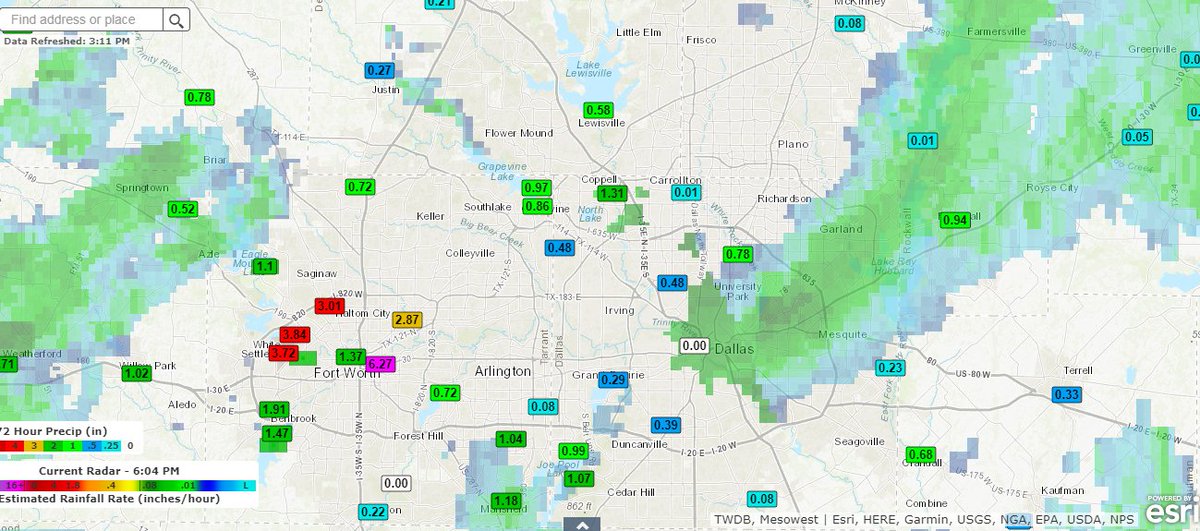
We'll be in the mid to upper 80s, some close to 90. Not the mid 90s seen earlier by some guidance but it's still warm. We've been so accustomed to warmth in October. It could be worse though yes. More importantly the models are not bone dry, but with opportunities.

DFW's high today so far is 72 which is the current temperature. It is the first sub-80 high since May 4th. The record high for the date is 101 back in 2011 while the record low is 46 from 1967 both safe.
0 likes   
The above post and any post by Ntxw is NOT an official forecast and should not be used as such. It is just the opinion of the poster and may or may not be backed by sound meteorological data. It is NOT endorsed by any professional institution including Storm2k. For official information, please refer to NWS products.

  Help support Storm2K!
Help Support Storm2K

User avatar
bubba hotep
S2K Supporter
S2K Supporter
Posts: 5611
Joined: Wed Dec 28, 2016 1:00 am
Location: Collin County Texas

Re: Texas Fall 2017

#282 Postby bubba hotep » Fri Sep 29, 2017 6:17 pm

Light rain most of the day here IMBY pushing the 3 day total over 2" which is a decent surprise, given the forecast from earlier in the week. I think the Wylie station might be off but I am a few miles away from it and CoCoRaHS reports confirm higher totals in the area.

Image
0 likes   
Winter time post are almost exclusively focused on the DFW area.

User avatar
bubba hotep
S2K Supporter
S2K Supporter
Posts: 5611
Joined: Wed Dec 28, 2016 1:00 am
Location: Collin County Texas

Re: Texas Fall 2017

#283 Postby bubba hotep » Fri Sep 29, 2017 6:19 pm

Also, DFW picked up enough rain to drop this September out of the Top 10 Driest!
0 likes   
Winter time post are almost exclusively focused on the DFW area.

User avatar
South Texas Storms
Professional-Met
Professional-Met
Posts: 4041
Joined: Thu Jun 24, 2010 12:28 am
Location: Houston, TX

Re: Texas Fall 2017

#284 Postby South Texas Storms » Fri Sep 29, 2017 6:52 pm

3 inches of rain at my parent's house on the north side of SA! Much needed since that area has missed out on several of the big rain events so far this year.
1 likes   

Ntxw
Storm2k Moderator
Storm2k Moderator
Posts: 21565
Joined: Wed Oct 21, 2009 6:34 pm
Location: DFW, Texas

Re: Texas Fall 2017

#285 Postby Ntxw » Sat Sep 30, 2017 1:44 pm

Euro and GFS both agree of the pattern change going into the second week of Oct. Source region is not terribly cold but quasi -EPO episode should yield a good pattern for significant front. Perhaps first 40s (lows) of the season for some.

Image

Image

It's good to be discussing the EPO again, sure sign winter is just around the block :D

The snow advance index didn't have a good record the past couple of seasons, but always a fun thing to watch just in case!

Image
3 likes   
The above post and any post by Ntxw is NOT an official forecast and should not be used as such. It is just the opinion of the poster and may or may not be backed by sound meteorological data. It is NOT endorsed by any professional institution including Storm2k. For official information, please refer to NWS products.


  Help support Storm2K!

Help Support Storm2K


Brent
S2K Supporter
S2K Supporter
Posts: 37146
Age: 35
Joined: Sun May 16, 2004 10:30 pm
Location: Tulsa Oklahoma
Contact:

Re: Texas Fall 2017

#286 Postby Brent » Sat Sep 30, 2017 6:24 pm

18z GFS has mid 40s just outside DFW at day 11 :double:

Actually 40s in Denton and Fort Worth
0 likes   
#neversummer

User avatar
hriverajr
Professional-Met
Professional-Met
Posts: 786
Joined: Tue Jul 19, 2005 12:16 am

Re: Texas Fall 2017

#287 Postby hriverajr » Sat Sep 30, 2017 8:00 pm

Got close to 7 inches here at my location in Del Rio this week... Still raining lightly at the moment. 90's? what 90's I'm happy.
2 likes   

weatherdude1108
Category 5
Category 5
Posts: 4179
Joined: Tue Dec 13, 2011 1:04 pm
Location: Northwest Austin/Cedar Park, TX

Re: Texas Fall 2017

#288 Postby weatherdude1108 » Sat Sep 30, 2017 11:18 pm

South Texas Storms wrote:3 inches of rain at my parent's house on the north side of SA! Much needed since that area has missed out on several of the big rain events so far this year.


We received 3 inches over the past week at my place also. Awesome news for those who have missed out previously!
0 likes   
The preceding post is NOT an official forecast, and should not be used as such. It is only the opinion of the poster and may or may not be backed by sound meteorological data. It is NOT endorsed by any professional institution including storm2k.org. For Official Information please refer to the NHC and NWS products.

User avatar
Cpv17
Category 5
Category 5
Posts: 4444
Joined: Wed Dec 07, 2016 2:24 pm
Location: Wharton/El Campo, TX

Re: Texas Fall 2017

#289 Postby Cpv17 » Sun Oct 01, 2017 5:18 am

Well that 06z GFS run was sure interesting to say the least. Has what appears to be a depression or a weak tropical storm into south TX this coming Saturday.
0 likes   

User avatar
TeamPlayersBlue
Category 5
Category 5
Posts: 3310
Joined: Tue Feb 02, 2010 1:44 am
Location: Denver/Applewood, CO

Re: Texas Fall 2017

#290 Postby TeamPlayersBlue » Sun Oct 01, 2017 10:20 pm

Excited were in Oct to watch the SAI. Yeah, it hasnt had the best record lately, but i still think its important for providing blocking in the higher latitudes later in the season, and a cold siberian PV pumps heights into the arctic.

Still think its a dry/warm winter but hopefully we can take advantage of the cold shots we get
0 likes   
Personal Forecast Disclaimer:
The posts in this forum are NOT official forecast and should not be used as such. They are just the opinion of the poster and may or may not be backed by sound meteorological data. They are NOT endorsed by any professional institution or storm2k.org. For official information, please refer to the NHC and NWS products.

Brent
S2K Supporter
S2K Supporter
Posts: 37146
Age: 35
Joined: Sun May 16, 2004 10:30 pm
Location: Tulsa Oklahoma
Contact:

Re: Texas Fall 2017

#291 Postby Brent » Sun Oct 01, 2017 11:36 pm

End of the 12z Euro had 40s outside DFW too, also highs in the 60s even in DFW :cold:

Definitely looks like the biggest front of the season sometime early next week
0 likes   
#neversummer

User avatar
TeamPlayersBlue
Category 5
Category 5
Posts: 3310
Joined: Tue Feb 02, 2010 1:44 am
Location: Denver/Applewood, CO

Re: Texas Fall 2017

#292 Postby TeamPlayersBlue » Mon Oct 02, 2017 5:59 am

Also, that pic Ntx posted, look how low the Arctic Sea Ice is. Goodness. I know its at its minimum right now but goodness thats low.
0 likes   
Personal Forecast Disclaimer:
The posts in this forum are NOT official forecast and should not be used as such. They are just the opinion of the poster and may or may not be backed by sound meteorological data. They are NOT endorsed by any professional institution or storm2k.org. For official information, please refer to the NHC and NWS products.

Yukon Cornelius
S2K Supporter
S2K Supporter
Posts: 1738
Age: 40
Joined: Thu Dec 20, 2012 9:23 pm
Location: Dean, TX/Westcliffe, CO

Re: Texas Fall 2017

#293 Postby Yukon Cornelius » Mon Oct 02, 2017 8:31 am

Picked up 3.5" of rain over the 3 day event. Not too bad! It also looks like more is on the way, midweek.
1 likes   
#neversummer

User avatar
Tireman4
S2K Supporter
S2K Supporter
Posts: 5679
Age: 58
Joined: Fri Jun 30, 2006 1:08 pm
Location: Humble, Texas
Contact:

Re: Texas Fall 2017

#294 Postby Tireman4 » Mon Oct 02, 2017 11:19 am

000
FXUS64 KHGX 021513
AFDHGX

Area Forecast Discussion
National Weather Service Houston/Galveston TX
1013 AM CDT Mon Oct 2 2017

.UPDATE...
Moisture continuing to make its way inland today, and with daytime
heating we should see scattered activity across much of SE TX this
afternoon. Current forecast appears to have things covered, so not
going with any significant changes with the update.41

&&

.DISCUSSION...


&&

.PREV DISCUSSION... /ISSUED 442 AM CDT Mon Oct 2 2017/

Showers have begun to move into the eastern parts of our area
along the leading edge of deeper moisture easily seen on GOES
total precipitable water vapor imagery. More development can be
expected today with an increase in coverage anticipated tonight
and on into Tuesday and Tuesday night as even deeper moisture
surges into the area from the east. Locally heavy rainfall will be
possible, and WPC has outlooked parts of our area in a marginal
risk on their Day 2 Excessive Rainfall Outlook. The area looks to
see a significant decrease in coverage/intensity from east to west
beginning some time during the day on Wednesday and especially on
into Thursday as precipitable water values lower underneath
building mid/ upper level high pressure. Above normal temperatures
are anticipated for the end of the week, and they`ll probably
continue into the weekend as we wait for a possible cold frontal
passage around seven days for now.
42

&&

.PRELIMINARY POINT TEMPS/POPS...
College Station (CLL) 90 74 85 73 87 / 20 30 60 50 30
Houston (IAH) 88 74 85 72 88 / 40 40 60 50 40
Galveston (GLS) 87 78 84 78 87 / 50 50 60 50 40

&&

.HGX WATCHES/WARNINGS/ADVISORIES...
TX...NONE.
GM...NONE.
0 likes   

Ntxw
Storm2k Moderator
Storm2k Moderator
Posts: 21565
Joined: Wed Oct 21, 2009 6:34 pm
Location: DFW, Texas

Re: Texas Fall 2017

#295 Postby Ntxw » Mon Oct 02, 2017 12:36 pm

Higher surface pressure is indicative of a chilly air mass. Flow from the northern latitudes.

Image

With some snow in the high rockies and upper plains. Can't wait!
3 likes   
The above post and any post by Ntxw is NOT an official forecast and should not be used as such. It is just the opinion of the poster and may or may not be backed by sound meteorological data. It is NOT endorsed by any professional institution including Storm2k. For official information, please refer to NWS products.


  Help support Storm2K!

Help Support Storm2K


User avatar
TeamPlayersBlue
Category 5
Category 5
Posts: 3310
Joined: Tue Feb 02, 2010 1:44 am
Location: Denver/Applewood, CO

Re: Texas Fall 2017

#296 Postby TeamPlayersBlue » Mon Oct 02, 2017 4:11 pm

384 on the GFS has a really nice, strong front coming down. Likely indications of the type of pattern to come 2nd half of Oct. Patterns like this is what we may expect at times.
0 likes   
Personal Forecast Disclaimer:
The posts in this forum are NOT official forecast and should not be used as such. They are just the opinion of the poster and may or may not be backed by sound meteorological data. They are NOT endorsed by any professional institution or storm2k.org. For official information, please refer to the NHC and NWS products.

Brent
S2K Supporter
S2K Supporter
Posts: 37146
Age: 35
Joined: Sun May 16, 2004 10:30 pm
Location: Tulsa Oklahoma
Contact:

Re: Texas Fall 2017

#297 Postby Brent » Tue Oct 03, 2017 12:10 am

I'm cautiously optimistic this could be the coolest October since I've been here... the bar is low. :lol:

Next week's front could be more significant than anything seen last October(coolest at DFW last October 51 and not til the 22nd)

The 0z GFS stays below normal the entire run once next Monday's front hits... :double:
0 likes   
#neversummer

Ntxw
Storm2k Moderator
Storm2k Moderator
Posts: 21565
Joined: Wed Oct 21, 2009 6:34 pm
Location: DFW, Texas

Re: Texas Fall 2017

#298 Postby Ntxw » Tue Oct 03, 2017 2:12 pm

SST anoms are increasing south of Alaska and the modeled above normal heights up that way looks promising for some -EPO. Hoping that trend continues deep into the fall.
0 likes   
The above post and any post by Ntxw is NOT an official forecast and should not be used as such. It is just the opinion of the poster and may or may not be backed by sound meteorological data. It is NOT endorsed by any professional institution including Storm2k. For official information, please refer to NWS products.


  Help support Storm2K!

Help Support Storm2K


texas1836
Tropical Storm
Tropical Storm
Posts: 223
Age: 54
Joined: Fri Aug 17, 2012 10:10 am
Location: Ruidoso, New Mexico

Re: Texas Fall 2017

#299 Postby texas1836 » Tue Oct 03, 2017 2:25 pm

Is anyone aware of any good GFS apps available?
0 likes   

User avatar
JDawg512
Category 5
Category 5
Posts: 1032
Age: 44
Joined: Mon Aug 26, 2013 8:56 pm
Location: Austin
Contact:

Re: Texas Fall 2017

#300 Postby JDawg512 » Tue Oct 03, 2017 2:38 pm

Getting a nice garden variety thunderstorm right now.

September monthly total, just a tad over 3.50"

If October can keep up and deliver, this rain miser will be very pleased.
2 likes   
Resident Rain Miser

I am a weather hobbyist living 3.5 miles south of Downtown Austin and in no way or fashion should anything I say concerning forecasts be taken seriously. Please check your local NWS for accurate weather forecasting and conditions.


Return to “USA & Caribbean Weather”

Who is online

Users browsing this forum: Google Adsense [Bot], Ralph's Weather and 25 guests