February 5-6: Super Tuesday Outbreak... 57 dead
Moderator: S2k Moderators
Forum rules

The posts in this forum are NOT official forecast and should not be used as such. They are just the opinion of the poster and may or may not be backed by sound meteorological data. They are NOT endorsed by any professional institution or STORM2K.
-
Squarethecircle
- Category 5

- Posts: 2165
- Joined: Fri Oct 19, 2007 4:00 pm
- Location: Fairfax, VA
-
simplykristi
- S2K Supporter

- Posts: 1220
- Joined: Sat May 10, 2003 1:59 pm
- Location: Near KCMO
- Contact:
Re: Mardi Gras Outbreak - February 4-6
I can't get either live stream to come up for me.
Kristi
Kristi
0 likes


Re: Mardi Gras Outbreak - February 4-6
Streaming coverage from Memphis is available here: http://www.wmcstations.com/
0 likes


-
JonathanBelles
- Professional-Met

- Posts: 11430
- Age: 35
- Joined: Sat Dec 24, 2005 9:00 pm
- Location: School: Florida State University (Tallahassee, FL) Home: St. Petersburg, Florida
- Contact:
Re:
CrazyC83 wrote:In the radar clutter, a 334 kt TVS over NE Shelby County...
For real, there are two TVS's near Tunica...
Tornado Vortex signature?
and which warning includes is Tunica (where is Tunica)?
0 likes
-
CrazyC83
- Professional-Met
- Posts: 34315
- Joined: Tue Mar 07, 2006 11:57 pm
- Location: Deep South, for the first time!
Re: Re:
fact789 wrote:CrazyC83 wrote:In the radar clutter, a 334 kt TVS over NE Shelby County...
For real, there are two TVS's near Tunica...
Tornado Vortex signature?
and which warning includes is Tunica (where is Tunica)?
Tunica = SW of Memphis, and yes TVS = tornado vortex signature. The 334 is probably fake as it probably was radar beam clutter.
0 likes
-
simplykristi
- S2K Supporter
- Posts: 1220
- Joined: Sat May 10, 2003 1:59 pm
- Location: Near KCMO
- Contact:
Re: Mardi Gras Outbreak - February 4-6
tidesong wrote:Streaming coverage from Memphis is available here: http://www.wmcstations.com/
This feed works for me. The others did not.
Kristi
0 likes

Re: Mardi Gras Outbreak - February 4-6
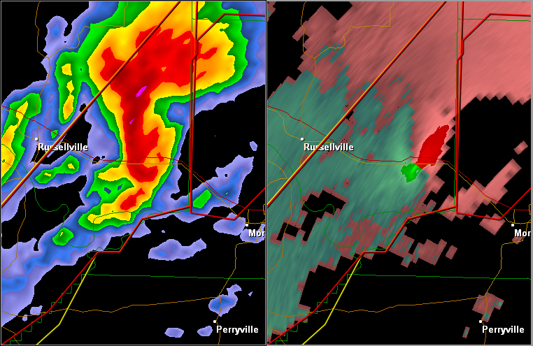
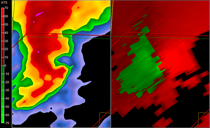
Storm in Conway County, Arkansas has some high NROT values associated with it's run. As example, I'm seeing about the same numbers right now as the Enterprise, Alabama storm last year.
My work laptop is crap for a video card or I'd capture a 3D scan of the storm with GR2AE.
--snoopj
My work laptop is crap for a video card or I'd capture a 3D scan of the storm with GR2AE.
--snoopj
Last edited by snoopj on Tue Feb 05, 2008 6:20 pm, edited 1 time in total.
0 likes
-
CrazyC83
- Professional-Met
- Posts: 34315
- Joined: Tue Mar 07, 2006 11:57 pm
- Location: Deep South, for the first time!
Re: Mardi Gras Outbreak - February 4-6
snoopj wrote:Storm in Conway County, Arkansas has some high NROT values associated with it's run. As example, I'm seeing about the same numbers right now as the Enterprise, Alabama storm last year.
--snoopj
Yep, easily capable of an EF3 or stronger.
0 likes
-
JonathanBelles
- Professional-Met
- Posts: 11430
- Age: 35
- Joined: Sat Dec 24, 2005 9:00 pm
- Location: School: Florida State University (Tallahassee, FL) Home: St. Petersburg, Florida
- Contact:
Re: Mardi Gras Outbreak - February 4-6
Conway County. Hard to believe there is not a tornado with this.
0 likes
-
CrazyC83
- Professional-Met
- Posts: 34315
- Joined: Tue Mar 07, 2006 11:57 pm
- Location: Deep South, for the first time!
Re: Mardi Gras Outbreak - February 4-6
RL3AO wrote:Conway County. Hard to believe there is not a tornado with this.
Probably a strong or violent tornado. Life-threatening situation there...
0 likes
Re: Mardi Gras Outbreak - February 4-6
RL3AO wrote:Conway County. Hard to believe there is not a tornado with this.
I believe there is. A report just popped up on my screen from 5:16pm local time of a tornado spotted on the ground.
0 likes
-
CrazyC83
- Professional-Met
- Posts: 34315
- Joined: Tue Mar 07, 2006 11:57 pm
- Location: Deep South, for the first time!
This is chilling:
MESOSCALE DISCUSSION 0163
NWS STORM PREDICTION CENTER NORMAN OK
0515 PM CST TUE FEB 05 2008
AREAS AFFECTED...NRN MS...WRN TN
CONCERNING...TORNADO WATCH 37...
VALID 052315Z - 060115Z
THE SEVERE WEATHER THREAT FOR TORNADO WATCH 37 CONTINUES.
SUPERCELLS ARE EXHIBITING VERY STRONG COUPLETS AND ARE PRODUCING
TORNADOES ACROSS NRN MS AND WRN TN. THIS CLUSTER OUTBREAK OF
TORNADOES WILL LIKELY PERSIST FOR SEVERAL HOURS.
AREA WIND PROFILERS ARE SHOWING IN EXCESS OF 300-500 M2/S2 0-1 SRH.
GIVEN STEEP MID TO UPPER LEVEL LAPSE RATES IN PLACE AND TREMENDOUS
SHEAR...A FEW OF THESE TORNADOES MAY BECOME VIOLENT...PRODUCING
DAMAGE OVER LONG SWATHS AND ENDANGERING LIVES.
..JEWELL.. 02/05/2008
ATTN...WFO...OHX...MEG...JAN...
33958992 33889092 34889043 36288949 36448890 36428810
35608797 34808840
0 likes
Return to “USA & Caribbean Weather”
Who is online
Users browsing this forum: AnnularCane, SnowyOwl31, South Texas Storms, wxman22 and 173 guests