Texas Spring 2012

U.S. & Caribbean Weather Discussions and Severe Weather Events

Moderator: S2k Moderators

Forum rules

The posts in this forum are NOT official forecast and should not be used as such. They are just the opinion of the poster and may or may not be backed by sound meteorological data. They are NOT endorsed by any professional institution or STORM2K.

Help Support Storm2K
Message
Author
weatherdude1108
Category 5
Category 5
Posts: 4228
Joined: Tue Dec 13, 2011 1:04 pm
Location: Northwest Austin/Cedar Park, TX

#321 Postby weatherdude1108 » Sat Apr 28, 2012 7:55 am

One major flood in the right place can fill that lake in a few days. Remember a month ago we had that heavy rain training over the hill country upstream and over the Colorado River Basin. Travis rose 10 feet just from that one rain event (I think(?).)

Still keeping my hopes up. :wink: :lightning: :rain:
0 likes   

weather_novice
Tropical Low
Tropical Low
Posts: 11
Joined: Fri Mar 16, 2012 4:08 am
Location: San Antonio, TX

Re: Texas Spring 2012

#322 Postby weather_novice » Sat Apr 28, 2012 10:13 am

For San Antonio we haven't seen this little rain in the month of April since 2005, which makes it the second worst precipitation in the month of April since 1871.

While that is sort of a big deal, the difference between a month with the second worst precipitation and an above average month might just be one rain event.
0 likes   

User avatar
somethingfunny
ChatStaff
ChatStaff
Posts: 3926
Age: 36
Joined: Thu May 31, 2007 10:30 pm
Location: McKinney, Texas

Re: Texas Spring 2012

#323 Postby somethingfunny » Sun Apr 29, 2012 4:48 pm

Still improving over last week, but the rate of improvement is slowing down. Most of the gains are in the Panhandle, I imagine.

Image

I'm starting to feel rain deprived too - but May is normally our wettest month, so we'll have to see what comes together.
0 likes   
I am not a meteorologist, and any posts made by me are not official forecasts or to be interpreted as being intelligent. These posts are just my opinions and are probably silly opinions.

User avatar
Texas Snowman
Storm2k Moderator
Storm2k Moderator
Posts: 6151
Joined: Fri Jan 25, 2008 11:29 am
Location: Denison, Texas

#324 Postby Texas Snowman » Sun Apr 29, 2012 8:24 pm

Fort Worth NWS, afternoon AFD:

"THE WEEKEND FORECAST ACQUIRES SOME UNCERTAINTY. MODELS CONTINUE TO WAIVER WITH RESPECT TO A VERY WEAK UPPER LEVEL LOW THAT COMES IN FROM THE PACIFIC. THE 00Z MODELS DROPPED THIS FEATURE COMPLETELY...BUT THE 12Z RUNS BROUGHT IT BACK. EVEN STILL...THE 12Z MODELS ARE NOT IN AGREEMENT ON WHETHER THERE WILL EVEN BE ENOUGH MOISTURE THIS FAR NORTH FOR ANY RAINFALL DUE TO THE DRYING EFFECTS OF SWLY 850 MB WINDS. WILL CONTINUE TO KEEP THE FORECAST DRY...BUT WILL SHOW AN INCREASE IN DAYTIME CLOUDINESS AND SLIGHT COOLING OF TEMPS AS A HEDGE.
0 likes   
The above post and any post by Texas Snowman is NOT an official forecast and should not be used as such. It is just the opinion of the poster and may or may not be backed by sound meteorological data. It is NOT endorsed by any professional institution including storm2k.org. For official information, please refer to NWS products.

User avatar
Texas Snowman
Storm2k Moderator
Storm2k Moderator
Posts: 6151
Joined: Fri Jan 25, 2008 11:29 am
Location: Denison, Texas

#325 Postby Texas Snowman » Mon Apr 30, 2012 2:36 pm

Starting to see some convection developing along the old outflow boundary along the Red River. Some of these might punch up to severe levels this afternoon.
0 likes   
The above post and any post by Texas Snowman is NOT an official forecast and should not be used as such. It is just the opinion of the poster and may or may not be backed by sound meteorological data. It is NOT endorsed by any professional institution including storm2k.org. For official information, please refer to NWS products.

User avatar
horselattitudesfarm
Category 1
Category 1
Posts: 315
Joined: Thu Jul 16, 2009 5:55 pm
Location: Asheville, NC (formerly from Dallas, TX)

Re: Texas Spring 2012

#326 Postby horselattitudesfarm » Tue May 01, 2012 9:21 pm

Read it and weep folks:

CLIMATE...
PRELIMINARY CLIMATE INFORMATION FOR APRIL 2012...
- CLL HAD THEIR 8TH DRIEST AND 5TH WARMEST APRIL ON RECORD
- IAH HAD THEIR 6TH WARMEST APRIL ON RECORD
- HOU HAD THEIR 4TH WARMEST APRIL ON RECORD
- GLS HAD THEIR 3RD WARMEST APRIL ON RECORD
0 likes   

User avatar
horselattitudesfarm
Category 1
Category 1
Posts: 315
Joined: Thu Jul 16, 2009 5:55 pm
Location: Asheville, NC (formerly from Dallas, TX)

Re: Texas Spring 2012

#327 Postby horselattitudesfarm » Tue May 01, 2012 10:08 pm

First the bad news: According to NOAA discussion:

TEMPERATURES WILL GRADUALLY WARM DURING THE NEXT SEVERAL DAYS AS
LOW LEVEL THICKNESS VALUES INCREASE COMPLEMENTS OF VEERING 850 MB
WINDS. THE SOUTHERLY SURFACE WINDS WILL ALSO DECREASE A BIT AND
GENERALLY RANGE BETWEEN 10 TO 15 MPH WHICH WILL ALSO HELP
ESTABLISH A WARMING TREND. HIGHS IN THE 90S WILL BECOME LIKELY

As if 9 degrees above average for the last 2 weeks wasn't warm enough.

Then kinda-maybe-quite possibly a little-tiny-eenie-meenie tiny sliver of hope on the horizon.......and also a poignant observation of our current crazy dry spell:

WARM AND DRY WEATHER PREVAILS INTO MONDAY AND TUESDAY...BUT THERE
IS SOME AGREEMENT IN THE LONG RANGE GUIDANCE THAT A MORE POTENT
TROUGH WILL BRING WIDESPREAD RAIN/STORMS BY MIDDLE OF NEXT WEEK.
THIS IS TYPICALLY OUR WETTEST PART OF THE YEAR AND IT HAS BEEN
QUITE AN UNUSAL DRY SPELL AFTER SUCH A WET START TO THE YEAR.

I've got inch-wide cracks in my yard already and had to start project 'Deep-Soak' 2 months early. (soaking with a pond pump and hose out of a pond behind our house since we can only water 2X a month with municipal water.
0 likes   

User avatar
Texas Snowman
Storm2k Moderator
Storm2k Moderator
Posts: 6151
Joined: Fri Jan 25, 2008 11:29 am
Location: Denison, Texas

Re: Texas Spring 2012

#328 Postby Texas Snowman » Tue May 01, 2012 10:48 pm

Yeah Steve McCauley of WFAA-TV Channel 8 in Dallas put on his Facebook page today that there are signs of a big pattern change sometime next week.

Hope so.
0 likes   
The above post and any post by Texas Snowman is NOT an official forecast and should not be used as such. It is just the opinion of the poster and may or may not be backed by sound meteorological data. It is NOT endorsed by any professional institution including storm2k.org. For official information, please refer to NWS products.

User avatar
Ntxw
Storm2k Moderator
Storm2k Moderator
Posts: 22731
Joined: Wed Oct 21, 2009 6:34 pm
Location: DFW, Texas

Re: Texas Spring 2012

#329 Postby Ntxw » Wed May 02, 2012 11:01 am

My guess is the culprit for warm, dry spell has been the neutral to very -PNA since early/mid April. Of course it doesn't always work the same as winter but in general at least for precipitation it does. Hopefully the change in the PNA to positive will/should bring wet weather back to Texas...it will at least allow troughs to dig a little closer. That is if the change verifies...

Image

Medium range euro actually does coincide with a wet/cool period coming up with that PNA+ and extends it through much of May. We'll see what happens and hope for the best. Being that it is May and infamous for outbreaks with April any digging troughs should be interesting.
0 likes   
The above post and any post by Ntxw is NOT an official forecast and should not be used as such. It is just the opinion of the poster and may or may not be backed by sound meteorological data. It is NOT endorsed by any professional institution including Storm2k. For official information, please refer to NWS products.

  Help support Storm2K!
Help Support Storm2K

weatherdude1108
Category 5
Category 5
Posts: 4228
Joined: Tue Dec 13, 2011 1:04 pm
Location: Northwest Austin/Cedar Park, TX

Re: Texas Spring 2012

#330 Postby weatherdude1108 » Wed May 02, 2012 4:06 pm

Ntxw wrote:My guess is the culprit for warm, dry spell has been the neutral to very -PNA since early/mid April. Of course it doesn't always work the same as winter but in general at least for precipitation it does. Hopefully the change in the PNA to positive will/should bring wet weather back to Texas...it will at least allow troughs to dig a little closer. That is if the change verifies...

Image

Medium range euro actually does coincide with a wet/cool period coming up with that PNA+ and extends it through much of May. We'll see what happens and hope for the best. Being that it is May and infamous for outbreaks with April any digging troughs should be interesting.


Bring it! :D :rain: I'm all eyes and ears! I've been looking at the discussions and 2-week forecasts everyday for some glimmer of hope. I could use the change in the pattern (or lack of pattern) to a NORMAL one for my own sanity.
0 likes   

User avatar
Ntxw
Storm2k Moderator
Storm2k Moderator
Posts: 22731
Joined: Wed Oct 21, 2009 6:34 pm
Location: DFW, Texas

Re: Texas Spring 2012

#331 Postby Ntxw » Wed May 02, 2012 5:16 pm

Snippet from this afternoon's AFD out of FW on the upcoming pattern change.

ON THE WEEKEND...AN UPPER LEVEL TROUGH IS FORECAST TO DEVELOP OVER
THE WESTERN CONUS WITH A PIECE OF ENERGY FROM THIS TROUGH
SEPARATING OFF AND DROPPING SOUTH INTO SOUTHERN CALIFORNIA ON
MONDAY. THE ECMWF IS MUCH MORE PROGRESSIVE WITH THE NORTHERN
TROUGH...DRAGGING IT ACROSS THE NORTHERN PLAINS ON TUESDAY. ON THE
OTHER HAND...THE GFS KEEPS THE NORTHERN TROUGH MOVING ACROSS
SOUTHERN CANADA. BECAUSE OF ITS MORE SOUTHWARD TRACK...THE ECMWF
BRINGS A COLD FRONT ACROSS NORTH TEXAS ON MONDAY...BUT THE GFS
STALLS THIS FRONT NEAR THE RED RIVER ON MONDAY. THEN...AS THE
UPPER LEVEL LOW FINALLY COMES ACROSS...THE GFS DEVELOPS WIDE
SPREAD PRECIPITATION ACROSS THE REGION ON WEDNESDAY. FOR
NOW...WILL SIDE WITH THE GFS AND INTRODUCE LOW POPS ACROSS ROUGHLY
THE NORTHERN HALF OF THE CWA ON MONDAY AND TUESDAY.


TODAY/S CLOUD COVER HAS KEPT TEMPERATURES WELL BELOW FORECASTED
HIGHS...EXCEPT IN THE WEST WHERE THE SKIES ARE MOSTLY CLEAR.
EXPECT WARM AND FAIRLY PERSISTENT TEMPERATURES TO CONTINUE THROUGH
THE WEEKEND. SLIGHTLY COOLER TEMPERATURES WILL LIKELY OCCUR NEXT
WEEK DUE TO THE RAIN CHANCES AND THE RETURN OF CLOUD COVER.

82/JLD
0 likes   
The above post and any post by Ntxw is NOT an official forecast and should not be used as such. It is just the opinion of the poster and may or may not be backed by sound meteorological data. It is NOT endorsed by any professional institution including Storm2k. For official information, please refer to NWS products.


  Help support Storm2K!

Help Support Storm2K


weatherdude1108
Category 5
Category 5
Posts: 4228
Joined: Tue Dec 13, 2011 1:04 pm
Location: Northwest Austin/Cedar Park, TX

#332 Postby weatherdude1108 » Wed May 02, 2012 10:35 pm

Bob Rose had an interesting/sobering write up yesterday on past Mays in Austin and the apparent trend over the last couple decades.

http://www.lcra.org/water/conditions/we ... olumn.html
0 likes   
The preceding post is NOT an official forecast, and should not be used as such. It is only the opinion of the poster and may or may not be backed by sound meteorological data. It is NOT endorsed by any professional institution including storm2k.org. For Official Information please refer to the NHC and NWS products.

User avatar
Rgv20
S2K Supporter
S2K Supporter
Posts: 2466
Age: 38
Joined: Wed Jan 05, 2011 5:42 pm
Location: Edinburg/McAllen Tx

#333 Postby Rgv20 » Wed May 02, 2012 11:30 pm

Look at the CFSv2 forecast rainfall anomalies for Week 2 (May9-May15)! Hope it verifies! :P

Image
0 likes   
The following post is NOT an official forecast and should not be used as such. It is just the opinion of the poster and may or may not be backed by sound meteorological data. It is NOT endorsed by any professional institution including storm2k.org For Official Information please refer to the NHC and NWS products.

Brandon8181
S2K Supporter
S2K Supporter
Posts: 424
Age: 41
Joined: Tue Jan 04, 2011 4:52 pm
Location: Tyler, TX
Contact:

Re: Texas Spring 2012

#334 Postby Brandon8181 » Thu May 03, 2012 9:49 am

I'm confused...Someone please help me understand..

The GFS for May 11th-13 has a large area of heavy precip over Texas. This has been someone consistant for the last few days picking up this system in the southern plains...

I was really thinking maybe a severe weather outbreak across the Southern Plains. I think it was a couple of days ago for Sunday May 13th, GFS was showing a large area of very high cape across Oklahoma...

But today, GFS still shows the large band of heavy precip across Texas for the 06z run, but I can't find any instability ratings as far a Cape or lifted index.

Can someone help me explain? I know we are really far out, and things change day to day; however, what I have learned in long term you want to look for consistancy... And its been showing a system in the southern plain for the last several days...

So breaking it down...

Why is there a big storm system but no instability factors?


Do you think we may get a severe weather outbreak across the Southern Plains from the 11th-13th?
0 likes   
I am not a meteorologist. Any post from me should be taken as hobby or fun educational information, but not an accurate source for weather information. Please, refer to your local weather station or National Weather Service for the most up to date information. :flag:

User avatar
Ntxw
Storm2k Moderator
Storm2k Moderator
Posts: 22731
Joined: Wed Oct 21, 2009 6:34 pm
Location: DFW, Texas

#335 Postby Ntxw » Thu May 03, 2012 12:10 pm

^ It is far to early to know quite simply. It is May and there is always the possibility with any system. Second jet does not look too strong (model) at this point. Another explanation could be that the GFS and various models are showing post frontal rain for some areas and severe weather may be limited to the immediate gulf coast. Again simply too early to even grasp at ideas for severe weather.
0 likes   
The above post and any post by Ntxw is NOT an official forecast and should not be used as such. It is just the opinion of the poster and may or may not be backed by sound meteorological data. It is NOT endorsed by any professional institution including Storm2k. For official information, please refer to NWS products.


  Help support Storm2K!

Help Support Storm2K


User avatar
Ntxw
Storm2k Moderator
Storm2k Moderator
Posts: 22731
Joined: Wed Oct 21, 2009 6:34 pm
Location: DFW, Texas

Re: Texas Spring 2012

#336 Postby Ntxw » Thu May 03, 2012 2:46 pm

Models today continue the idea of a closed upper low to track across the southern plains from baja (very winter like setup) which is good for a long duration rain event next week. Time frame is just now entering HPC forecast which I expect to grow in amount and coverage as things progress.

Image

Edit: The Euro actually advertises a line of thunderstorms tomorrow evening/sat morning across parts of Texas
0 likes   
The above post and any post by Ntxw is NOT an official forecast and should not be used as such. It is just the opinion of the poster and may or may not be backed by sound meteorological data. It is NOT endorsed by any professional institution including Storm2k. For official information, please refer to NWS products.


  Help support Storm2K!

Help Support Storm2K


weatherdude1108
Category 5
Category 5
Posts: 4228
Joined: Tue Dec 13, 2011 1:04 pm
Location: Northwest Austin/Cedar Park, TX

#337 Postby weatherdude1108 » Thu May 03, 2012 3:04 pm

It looks like the 6-10 and 8-14 day rainfall across most of Texas will be above normal and temperatures COOLER than normal during the same time frame.:D Can someone explain what the AO/PNA is exactly and how they interact with each other? A blurb was mentioned how they numbers on each are changing, which signals a change in the pattern. Trying to figure it out. Thanks. :wink:
0 likes   
The preceding post is NOT an official forecast, and should not be used as such. It is only the opinion of the poster and may or may not be backed by sound meteorological data. It is NOT endorsed by any professional institution including storm2k.org. For Official Information please refer to the NHC and NWS products.

User avatar
Ntxw
Storm2k Moderator
Storm2k Moderator
Posts: 22731
Joined: Wed Oct 21, 2009 6:34 pm
Location: DFW, Texas

Re: Texas Spring 2012

#338 Postby Ntxw » Fri May 04, 2012 6:21 pm

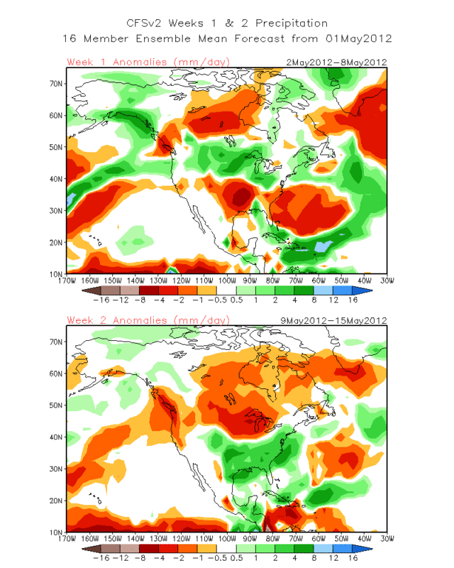
Ntxw wrote:Edit: The Euro actually advertises a line of thunderstorms tomorrow evening/sat morning across parts of Texas


Euro did a great job. Thunderstorm warnings west of the metroplex lining up to the northern hill country. Didn't see the other models pick it up. Of course this activity will probably wane down come sunset.
0 likes   
The above post and any post by Ntxw is NOT an official forecast and should not be used as such. It is just the opinion of the poster and may or may not be backed by sound meteorological data. It is NOT endorsed by any professional institution including Storm2k. For official information, please refer to NWS products.


  Help support Storm2K!

Help Support Storm2K


User avatar
Ntxw
Storm2k Moderator
Storm2k Moderator
Posts: 22731
Joined: Wed Oct 21, 2009 6:34 pm
Location: DFW, Texas

Re: Texas Spring 2012

#339 Postby Ntxw » Fri May 04, 2012 7:03 pm

Storm north/ne of Wichita Falls is putting down some serious hail heading in a southeast direction.

SEVERE WEATHER STATEMENT
NATIONAL WEATHER SERVICE NORMAN OK
701 PM CDT FRI MAY 4 2012

OKC033-TXC077-485-050015-
/O.CON.KOUN.SV.W.0234.000000T0000Z-120505T0015Z/
COTTON OK-CLAY TX-WICHITA TX-
701 PM CDT FRI MAY 4 2012

...A SEVERE THUNDERSTORM WARNING REMAINS IN EFFECT UNTIL 715 PM
CDT FOR EXTREME SOUTHEASTERN COTTON...NORTHWESTERN CLAY AND
EXTREME EASTERN WICHITA COUNTIES...

AT 657 PM CDT...NATIONAL WEATHER SERVICE METEOROLOGISTS DETECTED A
SEVERE THUNDERSTORM CAPABLE OF PRODUCING LARGE DESTRUCTIVE HAIL UP
TO BASEBALL SIZE AND DESTRUCTIVE WINDS IN EXCESS OF 70 MPH. THIS
STORM WAS LOCATED 7 MILES NORTHWEST OF PETROLIA...MOVING SOUTHEAST
AT 20 MPH.

LOCATIONS IMPACTED INCLUDE...
DEAN...TAYLOR AND CHARLIE.

PRECAUTIONARY/PREPAREDNESS ACTIONS...

MOVE INSIDE A STURDY BUILDING UNTIL THE STORM HAS PASSED.

&&

LAT...LON 3402 9850 3420 9840 3417 9815 3415 9814
3390 9836
TIME...MOT...LOC 2357Z 302DEG 20KT 3406 9835

$$

Very unstable air for these storms to work with should they hold together.
0 likes   
The above post and any post by Ntxw is NOT an official forecast and should not be used as such. It is just the opinion of the poster and may or may not be backed by sound meteorological data. It is NOT endorsed by any professional institution including Storm2k. For official information, please refer to NWS products.


  Help support Storm2K!

Help Support Storm2K


User avatar
Ntxw
Storm2k Moderator
Storm2k Moderator
Posts: 22731
Joined: Wed Oct 21, 2009 6:34 pm
Location: DFW, Texas

Re: Texas Spring 2012

#340 Postby Ntxw » Fri May 04, 2012 7:07 pm

Storm heading into Granbury W/SW of Ft Worth is showing some high reflectivity also.

SEVERE THUNDERSTORM WARNING
TXC221-050100-
/O.NEW.KFWD.SV.W.0098.120504T2356Z-120505T0100Z/

BULLETIN - EAS ACTIVATION REQUESTED
SEVERE THUNDERSTORM WARNING
NATIONAL WEATHER SERVICE FORT WORTH TX
656 PM CDT FRI MAY 4 2012

THE NATIONAL WEATHER SERVICE IN FORT WORTH HAS ISSUED A

* SEVERE THUNDERSTORM WARNING FOR...
HOOD COUNTY IN NORTH CENTRAL TEXAS...

* UNTIL 800 PM CDT

* AT 656 PM CDT...NATIONAL WEATHER SERVICE METEOROLOGISTS DETECTED A
SEVERE THUNDERSTORM CAPABLE OF PRODUCING QUARTER SIZE HAIL...AND
DAMAGING WINDS IN EXCESS OF 60 MPH. THIS STORM WAS LOCATED 4 MILES
NORTH OF LIPAN...MOVING EAST AT 25 MPH.

* THE SEVERE THUNDERSTORM WILL BE NEAR...
OAK TRAIL SHORES AROUND 730 PM...
GRANBURY AROUND 740 PM...

THIS WILL IMPACT I-20 BETWEEN MILE MARKERS 384 AND 385.

PRECAUTIONARY/PREPAREDNESS ACTIONS...

FOR YOUR PROTECTION MOVE TO A STURDY SHELTER UNTIL THE STORM HAS
PASSED.

IF YOU ARE CAUGHT OUTSIDE...SEEK SHELTER IN A STRONG BUILDING AND
STAY INSIDE...AWAY FROM WINDOWS UNTIL THE STORM HAS PASSED.

&&

LAT...LON 3255 9807 3255 9761 3233 9762 3236 9800
3251 9807
TIME...MOT...LOC 2356Z 287DEG 20KT 3257 9802

$$


85/NH
0 likes   
The above post and any post by Ntxw is NOT an official forecast and should not be used as such. It is just the opinion of the poster and may or may not be backed by sound meteorological data. It is NOT endorsed by any professional institution including Storm2k. For official information, please refer to NWS products.


  Help support Storm2K!

Help Support Storm2K


Return to “USA & Caribbean Weather”

Who is online

Users browsing this forum: Cpv17 and 48 guests