#333 Postby weatherdude1108 » Sun Jul 24, 2016 5:23 pm
000
FXUS64 KEWX 241955
AFDEWX
Area Forecast Discussion
National Weather Service Austin/San Antonio TX
255 PM CDT SUN JUL 24 2016
.SHORT TERM (Today through Monday)...
The heat will hang around for one more afternoon before a major
change in the weather comes late Monday. Heat index values this
afternoon are already up to 104 - 106 in spots across the I-35
corridor and the Coastal Plains. Due to increasing moisture an
isolated shower or storm is possible late this evening along the
sea breeze, but high resolution models keep that activity to a
minimum.
On Monday the ridge of high pressure weakens and pushes eastward.
This will open the door for two westward moving upper level
disturbances. Both right now can be seen on water vapor, one over
the lower Mississippi Valley, and the other over south Florida.
Models show the first disturbance kicking off a complex of storms
over Northeast Texas late tomorrow. This will move southwestward.
The combination of increased moisture, the outflow boundary from
the complex of storms, and daytime heating will lead to isolated
showers and thunderstorms late tomorrow into the evening hours.
The best chances for storms will be along and west of the US
Highway 281 Corridor. Precipitable Water values in forecast
soundings from the GFS approach 2 inches by Monday morning so
there will be the possibility of locally heavy rainfall from the
activity tomorrow afternoon. With those same soundings showing
limited CAPE and fairly weak shear the main threat from these
storms will be gusty winds in addition to the heavy rainfall.
Afternoon highs will "cool" a bit for Monday due to the increased
cloud cover. Heat Index values will still reach up to around the
105 mark.
&&
.LONG TERM (Monday Night through Saturday)...
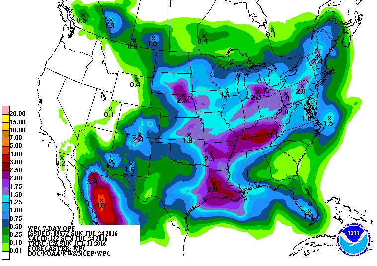
As the lower Mississippi Valley trough moves west across the state
Monday night rain chances will continue. The south Florida trough
will approach the state late in the day on Tuesday. The
combination of the lift caused by both of these disturbances,
daytime heating, residual boundaries, and daytime heating will
lead to increased coverage of showers and thunderstorms across
South Central Texas on Tuesday. Again with PW values around 2
inches brief locally heavy rainfall will be possible. Gusty
thunderstorm winds and lightning will remain the hazards from the
stronger thunderstorms. Highs Tuesday will be at or below normal
across the area, in the lower 90s, thanks to the cloud cover and
precipitation. The NAM and ECMWF show a focus for showers and
storms across our western counties Tuesday night into Wednesday as
the low moves across the Rio Grande Plains. Wednesday will bring
another decent shot of rain as the low slowly moves west and
moisture remains across South Central Texas.
From here the long term models diverge. The GFS has weak ridging
across the area Thursday and Friday, keeping the trough across the
Midwest farther north. The ECMWF has the south Florida trough
hanging around northern Mexico which maintains the weakness in the
ridge. This allows not only for sea breeze each day, but isolated
showers and storms across most areas Thursday, and east of I-35
Friday and Saturday. As the ECMWF has been consistent with the
weakness in the ridge, and moisture should remain pooled over
South Central Texas will side with it and continue slight chances
for precipitation through Saturday before finally drying us out.
Temperatures have not been at or below normal since early June,
and this chance of precipitation is our most solid chance since
early June as well.
0 likes
The preceding post is NOT an official forecast, and should not be used as such. It is only the opinion of the poster and may or may not be backed by sound meteorological data. It is NOT endorsed by any professional institution including storm2k.org. For Official Information please refer to the NHC and NWS products.


