SE TX/SW LA weather: Much cooler and WET after Tuesday
Moderator: S2k Moderators
Forum rules

The posts in this forum are NOT official forecast and should not be used as such. They are just the opinion of the poster and may or may not be backed by sound meteorological data. They are NOT endorsed by any professional institution or STORM2K.
-
Yankeegirl

- Category 5

- Posts: 3417
- Age: 50
- Joined: Sun May 23, 2004 11:59 pm
- Location: Cy-Fair, Northwest Houston
- Contact:
Re: SE TX/SW LA weather: Summer Pattern-HOT!!!
Well, at least today I can't say we did not even get a drop...I think we got about 100 drops out of that storm..Beggars can't be choosers. There is always hope for tomorrow.
0 likes
-
Ed Mahmoud
Re: SE TX/SW LA weather: Summer Pattern-HOT!!!
It sort of turned right to miss me.
The anvil is overhead, however, and looks impressive.
The anvil is overhead, however, and looks impressive.
0 likes
-
southerngale

- Retired Staff

- Posts: 27418
- Joined: Thu Oct 10, 2002 1:27 am
- Location: Southeast Texas (Beaumont area)
Re: SE TX/SW LA weather: Summer Pattern-HOT!!!
The storms that prompted the severe thunderstorm warning north of here fell apart before they got to me. Like *POOF*
Severe weather yesterday when it wasn't expected & there wasn't a severe thunderstorm watch. Watch today and a little bit of light rain, briefly. Weather is funny like that. It has a mind of its own.
At least we have a chance, even if it's not high, of rain each day this week.
Severe weather yesterday when it wasn't expected & there wasn't a severe thunderstorm watch. Watch today and a little bit of light rain, briefly. Weather is funny like that. It has a mind of its own.
At least we have a chance, even if it's not high, of rain each day this week.
0 likes
-
vbhoutex

- Storm2k Executive

- Posts: 29149
- Age: 74
- Joined: Wed Oct 09, 2002 11:31 pm
- Location: Cypress, TX
- Contact:
Re: SE TX/SW LA weather: Summer Pattern-HOT!!!
Ed Mahmoud wrote:It sort of turned right to miss me.
The anvil is overhead, however, and looks impressive.
Looks like it may miss most of Harris County except for the far NW corner just above Cypress.
0 likes
-
Yankeegirl
- Category 5
- Posts: 3417
- Age: 50
- Joined: Sun May 23, 2004 11:59 pm
- Location: Cy-Fair, Northwest Houston
- Contact:

-
PTrackerLA

- Category 5
- Posts: 5281
- Age: 42
- Joined: Thu Oct 10, 2002 8:40 pm
- Location: Lafayette, LA
Re: SE TX/SW LA weather: Summer Pattern-HOT!!!
High was only 88 degrees today with full sun! We certainly deserve it and have really caught up on the rainfall deficits with about 8.5" so far this month and decent rain chances for the next 7 days. For the first time since May I was thrilled to not have any showers around, it was just that nice of a day and the grounds are pretty soggy now!
0 likes
-
vbhoutex
- Storm2k Executive
- Posts: 29149
- Age: 74
- Joined: Wed Oct 09, 2002 11:31 pm
- Location: Cypress, TX
- Contact:
Re: SE TX/SW LA weather: Summer Pattern-HOT!!!
PTrackerLA wrote:High was only 88 degrees today with full sun! We certainly deserve it and have really caught up on the rainfall deficits with about 8.5" so far this month and decent rain chances for the next 7 days. For the first time since May I was thrilled to not have any showers around, it was just that nice of a day and the grounds are pretty soggy now!
Life should be so sweet!
0 likes
-
vbhoutex
- Storm2k Executive
- Posts: 29149
- Age: 74
- Joined: Wed Oct 09, 2002 11:31 pm
- Location: Cypress, TX
- Contact:
Re:
jasons wrote:Today might be our day. Southerly flow established, plenty of sun, and organized convection w/ disturbance to our north moving south today into the warm moist flow....looks like the table is set to me.
I am hoping the same. It at least gave me some hope when I saw the weather this am and what was situated to our NW.
0 likes
-
srainhoutx

- S2K Supporter

- Posts: 6919
- Age: 68
- Joined: Sun Jan 14, 2007 11:34 am
- Location: Haywood County, NC
- Contact:
Re: Re:
vbhoutex wrote:jasons wrote:Today might be our day. Southerly flow established, plenty of sun, and organized convection w/ disturbance to our north moving south today into the warm moist flow....looks like the table is set to me.
I am hoping the same. It at least gave me some hope when I saw the weather this am and what was situated to our NW.
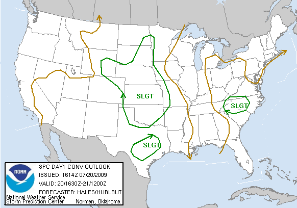
Look what the SPC just issued...
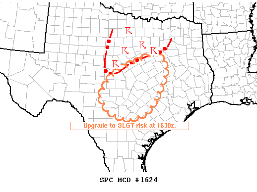
MESOSCALE DISCUSSION 1624
NWS STORM PREDICTION CENTER NORMAN OK
1048 AM CDT MON JUL 20 2009
AREAS AFFECTED...CNTRL TX
CONCERNING...OUTLOOK UPGRADE
VALID 201548Z - 201715Z
ONGOING TSTMS ARE EXPECTED TO ORGANIZE INTO A SWD-MOVING MCS TODAY
WITH THE THREAT FOR DAMAGING WINDS AND SOME HAIL. PARTS OF AREA
WILL BE UPGRADED TO A SLIGHT RISK AT 1630Z.
TSTMS WHICH INITIATED EARLIER THIS MORNING OVER WRN OK/NWRN TX ARE
ONGOING AS OF 1530Z WITH THE MOST INTENSE ACTIVITY FOCUSED IN A N-S
BAND FROM CLAY TO BROWN AND MCCULLOCH COUNTIES. ANOTHER STRONG
STORM CLUSTER WAS LOCATED OVER ELLIS COUNTY. REGIONAL VWP/PROFILER
DATA INDICATE THAT LOWER TROPOSPHERIC WAA IS LARGELY FORCING THIS
CONVECTION ALONG 20-30 KT SWLY LLJ AXIS. WHILE LLJ WILL UNDERGO
DIURNAL WEAKENING...12Z MODEL GUIDANCE SUGGESTS THAT AT LEAST MODEST
SLY LOW-LEVEL FLOW WILL CONTINUE TODAY ACROSS DISCUSSION
AREA...MAINTAINING WAA REGIME GIVEN NNWLY MID/HIGH-LEVEL WIND
FIELDS.
12Z OBSERVED SOUNDING DATA INDICATE THAT ONGOING TSTM CLUSTER
RESIDES ALONG ERN FRINGE OF STEEPER MIDLEVEL LAPSE RATES SITUATED
OVER THE ROCKIES AND ADJACENT HIGH PLAINS. WHEN COUPLED WITH
DAYTIME HEATING AND MOIST BOUNDARY LAYER CONDITIONS /DEWPOINTS OF
70-75F/...AIR MASS IS EXPECTED TO BECOME MODERATELY UNSTABLE WITH
MLCAPE INCREASING TO 1500-2500 J/KG. AS SUCH...EXPECT TSTMS TO
GRADUALLY INTENSIFY INTO AN ORGANIZED MCS WHICH WILL MOVE/PROPAGATE
SWD. LOCALLY DAMAGING WIND GUSTS WILL BE THE PRIMARY SEVERE THREAT
THOUGH SOME HAIL WILL ALSO BE POSSIBLE.
..MEAD.. 07/20/2009
ATTN...WFO...HGX...FWD...EWX...SJT...
0 likes
Re: SE TX/SW LA weather: Summer Pattern-HOT!!!
0 likes
Re: SE TX/SW LA weather: Summer Pattern-HOT!!!
Wife just called, had a 10 minute heavy shower over our house. Now the sun is trying to peak through..I will take it as we have gone from nothing, to sprinkles to heavy rain today..Maybe tomorrow will be the lucky day!
0 likes
-
vbhoutex
- Storm2k Executive
- Posts: 29149
- Age: 74
- Joined: Wed Oct 09, 2002 11:31 pm
- Location: Cypress, TX
- Contact:
Re: SE TX/SW LA weather: Summer Pattern-HOT!!!
Lots of noise, got dark, radar looked very menacing, temp drooped to 81ºf and NO RAIN! 
0 likes

Re: SE TX/SW LA weather: Summer Pattern-HOT!!!
This thread is so long that I didn't read every post. My question is if this is as hot as it's going to get all summer? My electric bill was decent, so figure it won't get any worse?
0 likes
-
southerngale
- Retired Staff
- Posts: 27418
- Joined: Thu Oct 10, 2002 1:27 am
- Location: Southeast Texas (Beaumont area)
Re: SE TX/SW LA weather: Summer Pattern-HOT!!!
vbhoutex wrote:Lots of noise, got dark, radar looked very menacing, temp drooped to 81ºf and NO RAIN!
I hear ya. Lots of clouds today. I heard a lot of thunder earlier, from nearby storms, but they never made it here. The radar was really lit up in this area and at one point or another, I think there were storms just to my east, just to my west, just to my north, and just to my south, but nada here.
Everything on radar seems to be falling apart, but I just noticed NWS has upped tonight's chances to 70%. What the heck? I haven't seen the chances that high in a long time! I'm gonna go read the discussion and see what they're expecting to happen, but it sounds great!
EDIT: Nevermind, in the written forecast below the forecast at a glance, it mentions before 7pm. When I saw tonight, I thought of nighttime, you know, when it's DARK outside.
Tonight: Thunderstorms likely before 7pm. Some of the storms could produce frequent lightning. Mostly cloudy, with a low around 74. South wind between 5 and 15 mph. Chance of precipitation is 70%.
0 likes
Return to “USA & Caribbean Weather”
Who is online
Users browsing this forum: SnowyOwl31 and 98 guests