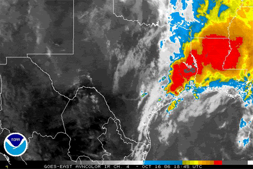
That is odd. May be they are not expecting the weather system to move off eastward as quickly? and may be they expect a wetter front on Wed/Thurs?southerngale wrote:Oh my....just saw the damage from the tornado just west of Beaumont in China...several homes destoryed. Piles of debris that look like what Rita did. So sad.
They showed flooding from here, with cars floating on streets, etc. I only saw a few minutes of it. If satellite and power can stay on, I'll record the news at 6pm so I can see more.
Btw, I noticed the Lake Charles NWS forecast for the next few days is way different than Houston's. I'm talking about Lake Charles' forecast for Beaumont too, which is usually fairly similar to Houston. What's the big differences they're seeing? (if anyone knows)
SE Texas weather thread #2 - Flood watch issued!
Moderator: S2k Moderators
Forum rules

The posts in this forum are NOT official forecast and should not be used as such. They are just the opinion of the poster and may or may not be backed by sound meteorological data. They are NOT endorsed by any professional institution or STORM2K.
-
Extremeweatherguy

- Category 5

- Posts: 11095
- Joined: Mon Oct 10, 2005 8:13 pm
- Location: Florida
0 likes
-
Yankeegirl

- Category 5
- Posts: 3417
- Age: 50
- Joined: Sun May 23, 2004 11:59 pm
- Location: Cy-Fair, Northwest Houston
- Contact:
Well its raining here once again... I think this is the last of it though... Good Riddance!!! also the rains arent really heavy and there is no thunder or lightning that I can see or hear...
Last edited by Yankeegirl on Mon Oct 16, 2006 5:39 pm, edited 1 time in total.
0 likes
-
PTrackerLA

- Category 5
- Posts: 5281
- Age: 42
- Joined: Thu Oct 10, 2002 8:40 pm
- Location: Lafayette, LA
-
Yankeegirl
- Category 5
- Posts: 3417
- Age: 50
- Joined: Sun May 23, 2004 11:59 pm
- Location: Cy-Fair, Northwest Houston
- Contact:
-
southerngale

- Retired Staff

- Posts: 27418
- Joined: Thu Oct 10, 2002 1:27 am
- Location: Southeast Texas (Beaumont area)
News Release from Jefferson County Sheriff`s Office:
On 10-16-06 at approximately 06:45 hours the Jefferson County Sheriff’s Office received several calls from citizens in West Jefferson County in China near Westbury and Turner Road stating a Tornado hit several houses in the 900 block of Turner Road.


I heard later it may have been straight line winds.
On 10-16-06 at approximately 06:45 hours the Jefferson County Sheriff’s Office received several calls from citizens in West Jefferson County in China near Westbury and Turner Road stating a Tornado hit several houses in the 900 block of Turner Road.
I heard later it may have been straight line winds.
0 likes
-
Yankeegirl
- Category 5
- Posts: 3417
- Age: 50
- Joined: Sun May 23, 2004 11:59 pm
- Location: Cy-Fair, Northwest Houston
- Contact:

-
southerngale
- Retired Staff
- Posts: 27418
- Joined: Thu Oct 10, 2002 1:27 am
- Location: Southeast Texas (Beaumont area)
FLASH FLOOD STATEMENT
NATIONAL WEATHER SERVICE LAKE CHARLES LA
714 PM CDT MON OCT 16 2006
TXC245-361-170100-
JEFFERSON TX-ORANGE TX-
714 PM CDT MON OCT 16 2006
...A FLASH FLOOD WARNING CONTINUES UNTIL 800 PM CDT FOR ORANGE AND
JEFFERSON COUNTIES...
AT 712 PM CDT...THE PUBLIC REPORTED FLASH FLOODING FROM A
THUNDERSTORM IN THE WARNED AREA. THE HEAVIEST RAINS ARE OCCURRING
NEAR SABINE PASS...PORT ARTHUR AND SOUTHERN ORANGE.
TORRENTIAL RAINFALL RATES OF AROUND 3 INCHES AN HOUR HAVE BEEN
REPORTED BY THE PUBLIC. THESE RAINS ARE FALLING ON TOP OF NEARLY 8
INCHES OF RAIN WHICH FELL EARLIER TODAY...OVERWHELMING DRAINAGE
SYSTEMS AND RESULTING IN STREET FLOODING.
BE ESPECIALLY CAUTIOUS AT NIGHT WHEN IT IS HARDER TO RECOGNIZE THE
DANGERS OF FLOODING. IF FLASH FLOODING IS OBSERVED ACT QUICKLY. MOVE
UP TO HIGHER GROUND TO ESCAPE FLOOD WATERS. DO NOT STAY IN AREAS
SUBJECT TO FLOODING WHEN WATER BEGINS RISING.
0 likes
-
southerngale
- Retired Staff
- Posts: 27418
- Joined: Thu Oct 10, 2002 1:27 am
- Location: Southeast Texas (Beaumont area)
-
george_r_1961

- S2K Supporter

- Posts: 3171
- Age: 64
- Joined: Sat Oct 12, 2002 9:14 pm
- Location: Carbondale, Pennsylvania


-
Extremeweatherguy
- Category 5
- Posts: 11095
- Joined: Mon Oct 10, 2005 8:13 pm
- Location: Florida
Today was equivalent to a weak TS landfall in many ways:
-High coastal tides (1-3 feet above normal)
-Flooding rains up to a foot
-Widespread weak tornadoes
-High winds in squalls
-Fast moving low clouds
-Low pressures
As for the "low pressures" part, here is a list of the minimum pressures experienced today across the area:
Houston (IAH) - 997mb
Tomball (Hooks) - 996mb
Houston (Hobby) - 997mb
Conroe - 996mb
Beaumont - 997mb
Galveston - 997mb
These pressures are equivalent to a TS.
0 likes

-
whereverwx
- Category 5
- Posts: 1107
- Joined: Mon May 31, 2004 10:15 pm
-
george_r_1961
- S2K Supporter
- Posts: 3171
- Age: 64
- Joined: Sat Oct 12, 2002 9:14 pm
- Location: Carbondale, Pennsylvania
-
whereverwx
- Category 5
- Posts: 1107
- Joined: Mon May 31, 2004 10:15 pm
-
Hybridstorm_November2001

- S2K Supporter
- Posts: 2817
- Joined: Sat Aug 21, 2004 2:50 pm
- Location: SW New Brunswick, Canada
- Contact:

Man what flood that was today in Clear Lake. The most intense widespread torrential rain since Alicia 2001. I found myself thrown into flash flooding no more than a block from the office at Bay Area and Space Center when I left at 4:40PM. Water up to the door in back office parking lot. Water up to the door again a few yards away on a side street trying to make it to Space Center. Made to space center with water up to the door and apartment parking lot up to car doors as people were moving them into the grass. At that point I realized this is serious street flooding and I must make into the Krogers parking lot. Some idiot was stuck parallel to the entrance trying to figure out what they were doing. They finally snapped to it and move. Again for the third and last time I crossed the street with water up to the door and made Double Daves Pizza my home for 2 hours..........darn to bad I did make across Bay Area to Sherlocks Pub but the Shiners at Daves were good enough. Amazing to see someone.....a complete fool flooded out in the Krogers parking lot. It was at least 3ft where the drains are located and this was above the street level. After some idle stranded stranger talk we all made it and home without a flooded out car. Why can people remember "turn around dont drown"...........that includes our cars as well.
0 likes
The following post is NOT an official forecast and should not be used as such. It is just the opinion of the poster and may or may not be backed by sound meteorological data. It is NOT endorsed by any professional institution including storm2k.org For Official Information please refer to the NHC and NWS products.
-
Extremeweatherguy
- Category 5
- Posts: 11095
- Joined: Mon Oct 10, 2005 8:13 pm
- Location: Florida
AREA FORECAST DISCUSSION
NATIONAL WEATHER SERVICE HOUSTON/GALVESTON TX
852 PM CDT MON OCT 16 2006
.DISCUSSION...THE HEAVY RAINFALL THAT HAS PLAGUED SOUTHEAST TEXAS
THE PAST 36 HOURS HAS FINALLY COME TO AN END AS WATER VAPOR
SATELLITE IMAGES INDICATES DRIER AIR MOVING EASTWARD ACROSS
CENTRAL AND EAST TEXAS THIS EVENING AS THE 500MB SHORTWAVE TROUGH
ACROSS CENTRAL TX CONTINUES TO MOVE EASTWARD. PRECIPITABLE WATER
VALUES HAVE DIMINISHED TO NEAR 1.4 INCHES PER 00Z CRP SOUNDING AS
THE WESTERLY LOW LEVEL FLOW CONTINUES TO BRING DRIER AIR IN THE
LOW TO MID LEVELS OF THE ATMOSPHERE. MSAS SURFACE ANALYSIS
INDICATES SOME DRIER AIR MOVING INTO THE WESTERN AND NORTHERN
PORTIONS OF THE CWA BEHIND THE TROUGH OF LOW PRESSURE ACROSS EAST
TX. BUT WITH THE COPIOUS AMOUNT OF RAINFALL THAT HAS BESIEGED THE
AREA RECENTLY...DEWPOINTS ARE NOT EXPECTED TO FALL MUCH TONIGHT
AND WITH THE LIGHT WINDS AND CLEARING SKIES...FOG WILL BE A MAJOR
CONCERN TONIGHT AND A DENSE FOG ADVISORY MAY BE NEEDED FOR MOST OF
THE CWA AFTER MIDNIGHT. WILL WAIT AND SEE IF FOG DEVELOPS LATE
THIS EVENING BEFORE ISSUING DENSE FOG ADVISORY. OTHERWISE...HAVE
ALREADY UPDATED GRIDS/ZONES TO REMOVE POPS FOR THE REST OF TONIGHT
AS WELL AS REMOVE FLOOD WATCH HEADLINE. 32
0 likes
-
PTrackerLA
- Category 5
- Posts: 5281
- Age: 42
- Joined: Thu Oct 10, 2002 8:40 pm
- Location: Lafayette, LA
Return to “USA & Caribbean Weather”
Who is online
Users browsing this forum: wxman22 and 52 guests