SE Texas weather thread #2 - Flood watch issued!
Moderator: S2k Moderators
Forum rules

The posts in this forum are NOT official forecast and should not be used as such. They are just the opinion of the poster and may or may not be backed by sound meteorological data. They are NOT endorsed by any professional institution or STORM2K.
-
vbhoutex

- Storm2k Executive

- Posts: 29149
- Age: 74
- Joined: Wed Oct 09, 2002 11:31 pm
- Location: Cypress, TX
- Contact:
Unless they are posted elsewhere I haven't seen any individuals totals for this event. Unfortunately my digital wired guage has quit working again(trash time!)
My back up was full to over flowing which is 5.5" or so. Using that and the weather bug near my home(about a mile as the crow flys) I got at least 5" today after midnight. Total at the weatherbug was 7.17" for the last two days. Doppler shows 6"-8" in my area.
My back up was full to over flowing which is 5.5" or so. Using that and the weather bug near my home(about a mile as the crow flys) I got at least 5" today after midnight. Total at the weatherbug was 7.17" for the last two days. Doppler shows 6"-8" in my area.
0 likes
-
PTrackerLA

- Category 5

- Posts: 5281
- Age: 42
- Joined: Thu Oct 10, 2002 8:40 pm
- Location: Lafayette, LA
CajunMama wrote:Weaken? before it gets to lafayette parish? tell me you're kidding me, pt! that never happens!
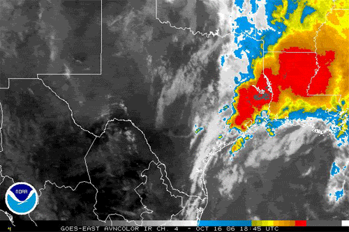
http://www.ghcc.msfc.nasa.gov/GOES/goeseastconusir.html
0 likes
-
hurrican19
- Tropical Storm

- Posts: 153
- Joined: Sun Jun 13, 2004 1:36 pm
- Location: Northwest Austin, TX
Emptied rain guage @ 6PM this evening in anticipation of the line of storms moving in from Houston. Boy I never did figure the amount of rain that would have fallen in about 45 minutes! 4.25" of rain was measured in my guage by the time the heaviest stuff had passed over (was still raining when I went and checked, but a LOT lighter). Rain has come to an end here, and here are my rainfall totals from Sunday till Tonight.
Sunday: 2.50"
Monday: Midnight - 6PM: 3.50"
Monday: 6PM - 9PM: 4.25"
Total 24 Hour Rainfall: 10.25"
Sunday: 2.50"
Monday: Midnight - 6PM: 3.50"
Monday: 6PM - 9PM: 4.25"
Total 24 Hour Rainfall: 10.25"
0 likes

hurrican19 wrote:Emptied rain guage @ 6PM this evening in anticipation of the line of storms moving in from Houston. Boy I never did figure the amount of rain that would have fallen in about 45 minutes! 4.25" of rain was measured in my guage by the time the heaviest stuff had passed over (was still raining when I went and checked, but a LOT lighter). Rain has come to an end here, and here are my rainfall totals from Sunday till Tonight.
Sunday: 2.50"
Monday: Midnight - 6PM: 3.50"
Monday: 6PM - 9PM: 4.25"
Total 24 Hour Rainfall: 10.25"
That's a lot of rain. Our area got 6 to 8 inches of rain.
Last edited by Ptarmigan on Mon Oct 16, 2006 9:57 pm, edited 1 time in total.
0 likes
-
Yankeegirl

- Category 5
- Posts: 3417
- Age: 50
- Joined: Sun May 23, 2004 11:59 pm
- Location: Cy-Fair, Northwest Houston
- Contact:
-
Extremeweatherguy

- Category 5
- Posts: 11095
- Joined: Mon Oct 10, 2005 8:13 pm
- Location: Florida
Looks like the SPC thinks we will be having bad luck with our weather again tomorrow too...
Day 2 outlook:
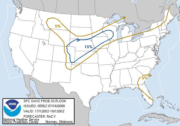
...SERN TX/LOWER MS VALLEY NEWD INTO THE WRN PORTIONS OF THE TN
VALLEY...
RICH BOUNDARY LAYER MOISTURE FROM SRN TX NEWD ALONG GULF COASTAL
STATES SHOULD ADVECTED NEWD AHEAD OF EWD MOVING COLD FRONT DURING
THE DAY ON WEDNESDAY. ALTHOUGH DEWPOINTS AT 70F OR HIGHER ARE
EXPECTED AS FAR NORTHEAST AS ERN AR...TEMPERATURES ALOFT WILL REMAIN
RELATIVELY WARM AND RESULT IN MODEST INSTABILITY AT BEST... WITH
MLCAPES LIKELY RANGING FROM AROUND 500 MB ACROSS THE NRN PORTION OF
THE SLIGHT RISK AREA TO AS HIGH AS 2000 J/KG ACROSS ERN TX.
CONVECTION MAY RESULT FROM TWO DIFFERENT LIFTING SOURCES. THE LOW
LATITUDE SHORTWAVE TROUGH SHOULD AID IN CONVECTION INITIATION IN SRN
TX EARLY IN THE PERIOD...WITH THIS CONVECTION SPREADING NEWD ACROSS
THE LOWER MID VALLEY DURING THE DAY AND INTO THE WRN TN VALLEY
OVERNIGHT. OTHER THUNDERSTORMS ARE ALSO EXPECTED TO DEVELOP DURING
THE MID/LATE AFTERNOON HOURS ALONG THE COLD FRONT...FROM IL INTO TX.
THE STRENGTH OF THE SHEAR AND INSTABILITY...ESPECIALLY FROM CENTRAL
AR SWWD INTO ERN TX WOULD FAVOR SEVERE STORMS... INCLUDING A FEW
SUPERCELLS. ALTHOUGH THE LOW LEVEL SHEAR MAY SUPPORT A TORNADO OR
TWO...THE RELATIVELY WARM TEMPERATURES ALOFT ...500 MB TEMPERATURES
FROM -6C TO-8C...AND WEAK LAPSE RATES INDICATE WIND DAMAGE AND
MARGINALLY SEVERE HAIL WOULD BE THE MAIN THREATS.
Day 2 outlook:
...SERN TX/LOWER MS VALLEY NEWD INTO THE WRN PORTIONS OF THE TN
VALLEY...
RICH BOUNDARY LAYER MOISTURE FROM SRN TX NEWD ALONG GULF COASTAL
STATES SHOULD ADVECTED NEWD AHEAD OF EWD MOVING COLD FRONT DURING
THE DAY ON WEDNESDAY. ALTHOUGH DEWPOINTS AT 70F OR HIGHER ARE
EXPECTED AS FAR NORTHEAST AS ERN AR...TEMPERATURES ALOFT WILL REMAIN
RELATIVELY WARM AND RESULT IN MODEST INSTABILITY AT BEST... WITH
MLCAPES LIKELY RANGING FROM AROUND 500 MB ACROSS THE NRN PORTION OF
THE SLIGHT RISK AREA TO AS HIGH AS 2000 J/KG ACROSS ERN TX.
CONVECTION MAY RESULT FROM TWO DIFFERENT LIFTING SOURCES. THE LOW
LATITUDE SHORTWAVE TROUGH SHOULD AID IN CONVECTION INITIATION IN SRN
TX EARLY IN THE PERIOD...WITH THIS CONVECTION SPREADING NEWD ACROSS
THE LOWER MID VALLEY DURING THE DAY AND INTO THE WRN TN VALLEY
OVERNIGHT. OTHER THUNDERSTORMS ARE ALSO EXPECTED TO DEVELOP DURING
THE MID/LATE AFTERNOON HOURS ALONG THE COLD FRONT...FROM IL INTO TX.
THE STRENGTH OF THE SHEAR AND INSTABILITY...ESPECIALLY FROM CENTRAL
AR SWWD INTO ERN TX WOULD FAVOR SEVERE STORMS... INCLUDING A FEW
SUPERCELLS. ALTHOUGH THE LOW LEVEL SHEAR MAY SUPPORT A TORNADO OR
TWO...THE RELATIVELY WARM TEMPERATURES ALOFT ...500 MB TEMPERATURES
FROM -6C TO-8C...AND WEAK LAPSE RATES INDICATE WIND DAMAGE AND
MARGINALLY SEVERE HAIL WOULD BE THE MAIN THREATS.
0 likes

Ok SE TX posters...........another major rain event this weekend?! Talk about saturation and river flooding if we get hammered again tomorrorw which looks to be a good bet followed by another major rain event over the weekend
AREA FORECAST DISCUSSION
NATIONAL WEATHER SERVICE HOUSTON/GALVESTON TX
508 AM CDT TUE OCT 17 2006
.DISCUSSION...
AN ACTIVE SUBTROPICAL JET WILL AFFECT SE TX OVER THE NEXT WEEK.
THE MAIN FORECAST ITEMS OF CONCERN ARE THE AREAS OF DENSE FOG THIS
MORNING AND THEN RAIN CHANCES AND AMOUNTS WEDNESDAY AND WEDNESDAY
NIGHT. IN THE EXTENDED PORTION...RAIN CHANCES AGAIN BECOME A
CONCERN OVER THE WEEKEND AND EARLY NEXT WEEK.
THE DENSE FOG SHOULD LIFT BY MID MORNING. AM EXPECTING ENOUGH
MIXING TO THIN OUT AND DISSIPATE THE FOG BETWEEN 7 AND 9 AM.
THE GFS AND NAM AGREED IN GENERAL CONCERNING THE AMOUNT OF
MOISTURE RETURN AHEAD OF THE APPROACHING COLD FRONT WEDNESDAY AND
WEDNESDAY NIGHT. BOTH MODELS UPPED THE PW/S TO BETWEEN 2.1 AND 2.4
INCHES WITH THE GFS ON THE HIGH END. LIKED THE GFS TIMING ON THE
FRONTAL PASSAGE LATE THURSDAY NIGHT AND EARLY WEDNESDAY MORNING.
WITH PW/S ABOVE THE NORMAL FOR THE LCH AND CRP SOUNDINGS ONCE
AGAIN...FELT THAT SOME LOCALLY HEAVY RAINFALL WILL BE POSSIBLE.
ALSO BELIEVE THAT RAIN CHANCES WILL BE HIGHER THAN THE PREVIOUS
FORECAST AND MORE IN LINE WITH THE MODEL OUTPUT...AND UPPED THESE
TO THE GOOD CHANCE CATEGORY WEDNESDAY AND LIKELY WEDNESDAY NIGHT.
WILL ADDRESS THE RAINFALL AMOUNTS AND RELATED CONCERNS IN THE
HAZARDOUS WEATHER OUTLOOK.
THE NEXT BIG RAIN EVENT MAY BE OCCURRING AT THE END OF THE
FORECAST PERIOD. OVER THE WEEKEND AND EARLY NEXT WEEK THE GFS SETS
UP ANOTHER SITUATION FOR AN APPROACHING WARM FRONT FROM THE SOUTH
ACCOMPANIED BY PLENTY OF LOW-LEVEL GULF MOISTURE AND MID-LEVEL
PACIFIC MOISTURE. FOR NOW...SOMETHING TO KEEP AN EYE OUT FOR.
0 likes
The following post is NOT an official forecast and should not be used as such. It is just the opinion of the poster and may or may not be backed by sound meteorological data. It is NOT endorsed by any professional institution including storm2k.org For Official Information please refer to the NHC and NWS products.
San Antonio Forecast Disc chimes in:
...WITH HIGH MOISTURE JUST TO THE SOUTH OF
SOUTH CENTRAL TEXAS BODES WELL FOR RAPID RETURN MOISTURE AND
CLOUDS FOR TONIGHT AND WEDNESDAY. STRONG LIFT ON WEDNESDAY IS
EXPECTED AHEAD OF ACTIVE 500 HPA TROF FORECAST TO MOVE OVER WEST
TEXAS WEDNESDAY AFTERNOON. WENT WITH CHANCES OF SHOWERS OVER THE
AREA AHEAD OF THIS STRONG FALL RAIN MAKING SYSTEM. COLD FRONT
COMING SOUTH WEDNESDAY IS EXPECTED TO COME ACROSS SOUTH CENTRAL
TEXAS WED. NIGHT/THURSDAY MORNING. WENT WITH TIMING OF FRONT PER
NAM SOLUTIONS TODAY...AS IT FIT MORE WITH ECMWF AND APPEARS GFS
WAS A LITTLE TOO FAST WITH THE COLD FRONT. CLEARING SKIES EXPECTED
THURSDAY IN THE DAY TO MOSTLY CLEAR THURSDAY NIGHT AND COOL. SOME
OF THE COOLEST LOWS SINCE EARLY APRIL OF THIS YEAR IS EXPECTED
FRIDAY MORNING.
RAPID RETURN MOISTURE IS FORECAST FOR FRIDAY NIGHT...AHEAD
OF NEXT PROGRESSIVE 500 HPA S/W TROF COMING FROM THE WEST
AND NORTHWEST. THIS FAST MOVING WEATHER SYSTEM IS EXPECTED
TO CARRY WITH IT ANOTHER COLD FRONT...THAT SWEEPS ACROSS
THE AREA SATURDAY NIGHT AND SUNDAY. COOL TEMPS ARE EXPECTED
IN THE DAY SUNDAY IN WAKE OF THIS COLD FRONT...WITH MODERATE
NORTHERLY WINDS. COMPOSITE FORECASTS SHOW INCREASING
CLOUDS MONDAY THROUGH TUESDAY WITH A CHANCE OF SHOWERS...
INITIALLY OVERRUNNING PATTERN MONDAY...THEN MORE OF A
DYNAMIC LIFTING PATTERN TUESDAY TO WEDNESDAY ALONG AND
AHEAD OF NEXT FAST MOVING 500 HPA TROF IN SOUTHERN STREAM
WESTERLIES.
0 likes
The following post is NOT an official forecast and should not be used as such. It is just the opinion of the poster and may or may not be backed by sound meteorological data. It is NOT endorsed by any professional institution including storm2k.org For Official Information please refer to the NHC and NWS products.


wow! What a wild day it was in the Houston area. I hope everybody gets at least some time to dry out a little bit before the next big rain comes. I lived in Houston for four years, so I know how intense the rain and flooding can be (Allision 2001). Sometimes it seems that every major rainfall event likes to head towards Houston for some reason.
0 likes

All I know is that here in Gretna I woke up at around 3:20 am for absolutly no reason,decided to change the TV to channel 4 right in time to see the tornado warning for jefferson parish that supposedly was going to be passing over my house in about 7 min.Had to haul you know what into the house from the fema trailer only to have nothing even notworthy to report.Not even really any rain.
Very odd that I just woke up out of the blue though,thats not like me and I normally sleep through about anything.
Very odd that I just woke up out of the blue though,thats not like me and I normally sleep through about anything.
0 likes
-
southerngale

- Retired Staff

- Posts: 27418
- Joined: Thu Oct 10, 2002 1:27 am
- Location: Southeast Texas (Beaumont area)
There are a lot of schools and roads closed today due to the flooding. A 20-year old guy in Jasper drowned in floodwaters yesterday. 
There were about a dozen homes destroyed or severely damaged just west of Beaumont, in China. Fortunately, nobody was killed and there were only minor injuries. One of the homes had just completed Rita repairs 2 weeks earlier. One little girl had gotten out of bed to get ready for school and 5 minutes later, some kind of pole crashed through her bedroom and landed on her bed!
One man was in the shower when the tornado hit and he was running around in the nude trying to find his wife after their house was torn to pieces. She was buried under a filing cabinet and something else, but managed to escape with only cuts and bruises.
Btw, apparently the tornado wasn't confirmed, but an entire street had either destroyed or damaged homes and homes on nearby streets were untouched, with just scattered debris from how windy it was in all of Southeast Texas.
The Salvation Army moved in quickly and set up base at First Baptist Church to help everyone and the community has come together to start helping each other.
I don't have a record at my house of exactly how much rain I received, but 10-12 inches was reported nearby, and that seems logical. There were a lot of areas in Jefferson and Hardin Counties that received 8 - 12 inches of rain. Now I see that SPC has us in a slight risk of severe weather again tomorrow - say it isn't so!
0 likes
-
HouTXmetro

- Category 5
- Posts: 3949
- Joined: Sun Jun 13, 2004 6:00 pm
- Location: District of Columbia, USA
-
PTrackerLA
- Category 5
- Posts: 5281
- Age: 42
- Joined: Thu Oct 10, 2002 8:40 pm
- Location: Lafayette, LA
CajunMama wrote:I don't know how bad it got here in lafayette during the night...i slept through it! I think there was so lightning or i may have dreamt it! NWS said we only got 1/4" from it betweem 10pm and 1am. Only 14" more inches to go to get to our normal percipitation level! Maybe next time!
The line split in two right before Lafayette so we were between the heaviest storms...go figure right? We received the lowest amont of rainfall according to the storm total image, I don't understand why it doesn't rain here. Not even an inch!!! http://radar.weather.gov/radar.php?rid= ... 11&loop=no
0 likes
What HouTXmetro.....today?!
0 likes
The following post is NOT an official forecast and should not be used as such. It is just the opinion of the poster and may or may not be backed by sound meteorological data. It is NOT endorsed by any professional institution including storm2k.org For Official Information please refer to the NHC and NWS products.
Return to “USA & Caribbean Weather”
Who is online
Users browsing this forum: wxman22 and 52 guests