Texas Summer 2016

U.S. & Caribbean Weather Discussions and Severe Weather Events

Moderator: S2k Moderators

Forum rules

The posts in this forum are NOT official forecast and should not be used as such. They are just the opinion of the poster and may or may not be backed by sound meteorological data. They are NOT endorsed by any professional institution or STORM2K.

Help Support Storm2K
Message
Author
User avatar
dhweather
S2K Supporter
S2K Supporter
Posts: 6199
Joined: Sat Aug 14, 2004 9:29 pm
Location: Heath, TX
Contact:

Re: Texas Summer 2016

#381 Postby dhweather » Tue Aug 02, 2016 10:47 am

weatherdude1108 wrote:
dhweather wrote:
weatherdude1108 wrote:Cat. 5 in the Gulf? Granted it is model lala land right now, but YIKES.


I like the way you think! :lol:


:lol:
Thanks! I've seen it mentioned time and again over the years. How did that phrase originally start? I think it was before I joined this forum. Such a classic!
:cheesy:


It was born in Talkin' Tropics - from various model outputs, usually longer range.

examples:


"The CMC has a cat 5 in the gulf in 120 hours"
"The GFS has a cat 5 in the gulf in 96 hours"
"The Euro has a cat 5 in the gulf in 108 hours"


So the spin became just "cat 5 in the gulf"
0 likes   
The above post and any post by dhweather is NOT an official forecast and should not be used as such. It is just the opinion of the poster and may or may not be backed by sound meteorological data. It is NOT endorsed by any professional institution including storm2k.org. For official information, please refer to NWS products.

weatherdude1108
Category 5
Category 5
Posts: 4228
Joined: Tue Dec 13, 2011 1:04 pm
Location: Northwest Austin/Cedar Park, TX

Re: Texas Summer 2016

#382 Postby weatherdude1108 » Tue Aug 02, 2016 3:43 pm

Wonderful. :sun: I leave for the Sierras in California tomorrow through next Tuesday. Lows in the 40s, one day 39! :Bcool:


000
FXUS64 KEWX 021904
AFDEWX

Area Forecast Discussion
National Weather Service Austin/San Antonio TX
204 PM CDT TUE AUG 2 2016

.SHORT TERM (Tonight through Wednesday Night)...

Mid-level anticyclone has become centered over South Central Tx
and looks to further dry out low levels and raise max temps.

Expansion of the mid-level ridge into the Northern Plains should
result in lighter sfc winds over TX, which should allow for
better cooling overnight while continuing trends for fewer low
clouds at daybreak.

&&

.LONG TERM (Thursday through Tuesday)...

No impacts from newly formed TS Earl are expected to reach this
far into TX as the high pressure at mid levels maintains its
intensity over Central Tx late this week into the weekend. A
subtle deepening of onshore winds Thursday into Friday could lead
to a few showers and storms forming over our far SErn counties by
Friday, but could also mean warmer min temps by a degree or two
Thursday morning through the weekend. The slightly deeper moist
layer resulting from deeper onshore flow could take a degree or
two off weekend highs, but heat indices are expected to remain
high through the extended periods. [b]The most recent of model runs
have trended toward the high pressure aloft remaining entrenched
over TX whereas earlier runs had suggested the ridge center to
drift north and allow for some moderation in temperatures. With
this unfortunate trend,
will go ahead and update the HWO to extend
concerns for elevated heat indices of 104 to 109 degrees for the
remainder of the extended forecast.
[/b]


June Lake, CA

Tuesday
08/02
84 | 46 °F
Tuesday 0 % Precip. / 0 in
Sunny. High 84F. Winds WSW at 10 to 20 mph.
Tuesday Night 0 % Precip. / 0 in
Clear skies. Low 46F. Winds WNW at 10 to 15 mph.

Wednesday
08/03
85 | 46 °F
Wednesday 0 % Precip. / 0 in
Sunny skies. High near 85F. ENE winds shifting to WSW at 10 to 15 mph.
Wednesday Night 0 % Precip. / 0 in
Mostly clear. Low 46F. Winds NW at 5 to 10 mph.

Thursday
08/04
81 | 43 °F
Thursday 20 % Precip. / 0 in
Sunny skies. High 81F. Winds SSW at 10 to 20 mph.
Thursday Night 0 % Precip. / 0 in
Clear. Low 43F. Winds WSW at 10 to 15 mph.

Friday
08/05
79 | 40 °F
Friday 0 % Precip. / 0 in
Sunny. High 79F. Winds SW at 10 to 20 mph.
Friday Night 0 % Precip. / 0 in
Clear skies. Low near 40F. W winds at 10 to 15 mph, decreasing to less than 5 mph.

Saturday
08/06
80 | 39 °F
Saturday 0 % Precip. / 0 in
Sunny. High near 80F. Winds SSW at 10 to 20 mph.
Saturday Night 0 % Precip. / 0 in
Clear skies. Low 39F. Winds WSW at 10 to 20 mph.

Sunday
08/07
79 | 40 °F
Sunday 0 % Precip. / 0 in
Sunny. High 79F. Winds SSW at 10 to 20 mph.
Sunday Night 0 % Precip. / 0 in
Clear skies. Low around 40F. W winds at 10 to 15 mph, decreasing to less than 5 mph.

Monday
08/08
79 | 42 °F
Monday 0 % Precip. / 0 in
Sunny. High 79F. Winds SSW at 10 to 20 mph.
Monday Night 0 % Precip. / 0 in
Clear skies. Low 42F. Winds W at 10 to 15 mph.
0 likes   
The preceding post is NOT an official forecast, and should not be used as such. It is only the opinion of the poster and may or may not be backed by sound meteorological data. It is NOT endorsed by any professional institution including storm2k.org. For Official Information please refer to the NHC and NWS products.

User avatar
JDawg512
Category 5
Category 5
Posts: 1075
Age: 45
Joined: Mon Aug 26, 2013 8:56 pm
Location: Austin
Contact:

Re: Texas Summer 2016

#383 Postby JDawg512 » Tue Aug 02, 2016 5:23 pm

I'm not surprised by EWXs discussion one bit. It only confirms what I said yesterday.

Believe me, I would like nothing more than to be wrong and would like nothing more than to see a stream of moisture and above normal rainfall for the last half of August.

We'll see how the forecast looks in 7 days.
0 likes   
Resident Rain Miser

I am a weather hobbyist living 3.5 miles south of Downtown Austin and in no way or fashion should anything I say concerning forecasts be taken seriously. Please check your local NWS for accurate weather forecasting and conditions.

aggiecutter
Category 5
Category 5
Posts: 1753
Joined: Thu Oct 14, 2004 9:22 pm
Location: Texarkana

Re: Texas Summer 2016

#384 Postby aggiecutter » Tue Aug 02, 2016 6:06 pm

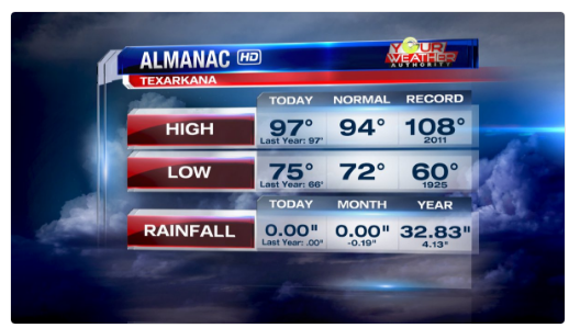
On this date, back in 2011:

Image
0 likes   

User avatar
Ntxw
Storm2k Moderator
Storm2k Moderator
Posts: 22783
Joined: Wed Oct 21, 2009 6:34 pm
Location: DFW, Texas

Re: Texas Summer 2016

#385 Postby Ntxw » Tue Aug 02, 2016 7:00 pm

Keep your eyes on the West Pacific. Euro and ensembles are supporting a big Typhoon interacting with the jet stream once it re-curves near Japan. If this is so, there would be implications down the road for a more potent pattern shift as we all know this time of year when the typhoons start recurving, they can interfere with the stale patterns. 98W seems like a good candidate.
1 likes   
The above post and any post by Ntxw is NOT an official forecast and should not be used as such. It is just the opinion of the poster and may or may not be backed by sound meteorological data. It is NOT endorsed by any professional institution including Storm2k. For official information, please refer to NWS products.

  Help support Storm2K!
Help Support Storm2K

aggiecutter
Category 5
Category 5
Posts: 1753
Joined: Thu Oct 14, 2004 9:22 pm
Location: Texarkana

Re: Texas Summer 2016

#386 Postby aggiecutter » Tue Aug 02, 2016 8:26 pm

Joe Bastardi ‏@BigJoeBastardi 2h2 hours ago Pennsylvania, USA
Euro seeing possible northern gulf problems from tail of trough dropping ssw in 4-8 day period
0 likes   

User avatar
TeamPlayersBlue
Category 5
Category 5
Posts: 3445
Joined: Tue Feb 02, 2010 1:44 am
Location: Denver/Applewood, CO

Re: Texas Summer 2016

#387 Postby TeamPlayersBlue » Thu Aug 04, 2016 9:54 am

Ntxw wrote:Keep your eyes on the West Pacific. Euro and ensembles are supporting a big Typhoon interacting with the jet stream once it re-curves near Japan. If this is so, there would be implications down the road for a more potent pattern shift as we all know this time of year when the typhoons start recurving, they can interfere with the stale patterns. 98W seems like a good candidate.


Heard about this yesterday. Maybe a dry front coming in our future? I'll take it.

Also watching the warm blob in the Pacific. Recently found the analog page on tropical tidbits and shows the blob sticking around for a bit. Lets pray!
0 likes   
Personal Forecast Disclaimer:
The posts in this forum are NOT official forecast and should not be used as such. They are just the opinion of the poster and may or may not be backed by sound meteorological data. They are NOT endorsed by any professional institution or storm2k.org. For official information, please refer to the NHC and NWS products.

User avatar
Ntxw
Storm2k Moderator
Storm2k Moderator
Posts: 22783
Joined: Wed Oct 21, 2009 6:34 pm
Location: DFW, Texas

Re: Texas Summer 2016

#388 Postby Ntxw » Thu Aug 04, 2016 10:32 am

98W has become Omais in the WPAC and will likely become a typhoon. This is a very large system in terms of size and is something capable of buckling the jet stream as it moves north.
0 likes   
The above post and any post by Ntxw is NOT an official forecast and should not be used as such. It is just the opinion of the poster and may or may not be backed by sound meteorological data. It is NOT endorsed by any professional institution including Storm2k. For official information, please refer to NWS products.


  Help support Storm2K!

Help Support Storm2K


gpsnowman
S2K Supporter
S2K Supporter
Posts: 3185
Joined: Fri Jan 07, 2011 10:35 am
Location: Grand Prairie Tx

Re: Texas Summer 2016

#389 Postby gpsnowman » Thu Aug 04, 2016 10:47 am

Ntxw wrote:98W has become Omais in the WPAC and will likely become a typhoon. This is a very large system in terms of size and is something capable of buckling the jet stream as it moves north.

Any relief is needed so let's hope it does. 103 for the high today. Just plain nasty and gross. I am so ready for the first "cool" front.
0 likes   

User avatar
Tireman4
S2K Supporter
S2K Supporter
Posts: 5853
Age: 59
Joined: Fri Jun 30, 2006 1:08 pm
Location: Humble, Texas
Contact:

Re: Texas Summer 2016

#390 Postby Tireman4 » Thu Aug 04, 2016 10:50 am

I....cant....take...this...anymore.....I hate Summer. Come on September 25th....oh by the way, we need to have our prognostication contest again....
0 likes   

User avatar
TeamPlayersBlue
Category 5
Category 5
Posts: 3445
Joined: Tue Feb 02, 2010 1:44 am
Location: Denver/Applewood, CO

Re: Texas Summer 2016

#391 Postby TeamPlayersBlue » Thu Aug 04, 2016 11:34 am

About 6 more weeks guys, just hang in there!
0 likes   
Personal Forecast Disclaimer:
The posts in this forum are NOT official forecast and should not be used as such. They are just the opinion of the poster and may or may not be backed by sound meteorological data. They are NOT endorsed by any professional institution or storm2k.org. For official information, please refer to the NHC and NWS products.

Brent
S2K Supporter
S2K Supporter
Posts: 38087
Age: 36
Joined: Sun May 16, 2004 10:30 pm
Location: Tulsa Oklahoma
Contact:

Re: Texas Summer 2016

#392 Postby Brent » Thu Aug 04, 2016 12:02 pm

I'll be honest... this summer really hasn't bothered me THAT much

until this week...

Omg this weather sucks. I'm counting the weeks... need relief :raincloud: :jacket:
0 likes   
#neversummer

aggiecutter
Category 5
Category 5
Posts: 1753
Joined: Thu Oct 14, 2004 9:22 pm
Location: Texarkana

Re: Texas Summer 2016

#393 Postby aggiecutter » Fri Aug 05, 2016 8:34 am

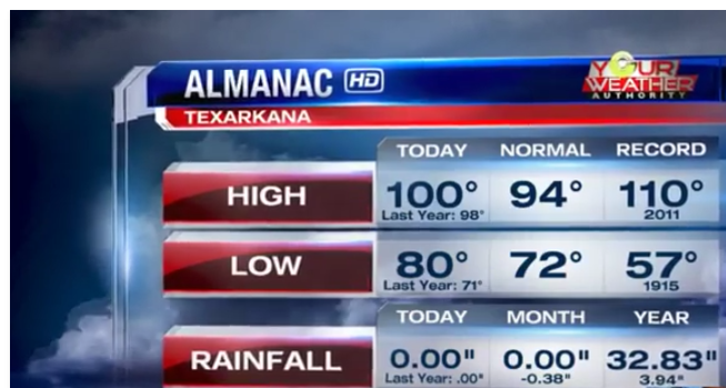
On this date back in 2011:

Image
0 likes   

User avatar
Ntxw
Storm2k Moderator
Storm2k Moderator
Posts: 22783
Joined: Wed Oct 21, 2009 6:34 pm
Location: DFW, Texas

Re: Texas Summer 2016

#394 Postby Ntxw » Fri Aug 05, 2016 7:27 pm

It's subtle but some guidance (including ECMWF) are showing some changes. Not a fall front by any means, but would break this rut of a pattern we are in and maybe a wind shifting front by mid month. Typhoon rule. Omais will buckle the jet stream.

Image

Image
0 likes   
The above post and any post by Ntxw is NOT an official forecast and should not be used as such. It is just the opinion of the poster and may or may not be backed by sound meteorological data. It is NOT endorsed by any professional institution including Storm2k. For official information, please refer to NWS products.


  Help support Storm2K!

Help Support Storm2K


aggiecutter
Category 5
Category 5
Posts: 1753
Joined: Thu Oct 14, 2004 9:22 pm
Location: Texarkana

Re: Texas Summer 2016

#395 Postby aggiecutter » Fri Aug 05, 2016 8:10 pm

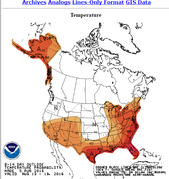
:uarrow: I was thinking the same thing when I saw the CPC 8-14.

Image
0 likes   

User avatar
vbhoutex
Storm2k Executive
Storm2k Executive
Posts: 29112
Age: 73
Joined: Wed Oct 09, 2002 11:31 pm
Location: Cypress, TX
Contact:

Re: Texas Summer 2016

#396 Postby vbhoutex » Fri Aug 05, 2016 8:33 pm

Ntxw wrote:It's subtle but some guidance (including ECMWF) are showing some changes. Not a fall front by any means, but would break this rut of a pattern we are in and maybe a wind shifting front by mid month. Typhoon rule. Omais will buckle the jet stream.

http://i66.tinypic.com/2mdgu45.png

http://i65.tinypic.com/25uty0i.png

Maybe for N TX. Looks like SOSDD for SE TX. :cry: August is traditionally our hottest month. I guess I can dream. :cheesy:
0 likes   
Skywarn, C.E.R.T.
Please click below to donate to STORM2K to help with the expenses of keeping the site going:
Image

A.V.

Re: Texas Summer 2016

#397 Postby A.V. » Fri Aug 05, 2016 9:54 pm

vbhoutex wrote:
Ntxw wrote:It's subtle but some guidance (including ECMWF) are showing some changes. Not a fall front by any means, but would break this rut of a pattern we are in and maybe a wind shifting front by mid month. Typhoon rule. Omais will buckle the jet stream.

http://i66.tinypic.com/2mdgu45.png

http://i65.tinypic.com/25uty0i.png

Maybe for N TX. Looks like SOSDD for SE TX. :cry: August is traditionally our hottest month. I guess I can dream. :cheesy:


It's worth noting that August only became the hottest month in SE TX starting with the 1981-2010 normals; historically (as recently as 1971-2000), it was July, not August, that was the hottest month. So, chances are, that August heat is only a temporary trend in the grand climactic scheme.

1971-2000 for Houston, HOU:
http://i.imgur.com/ouoOK0D.png

Also, if the jetstream is in that much of a buckle, then rain chances will follow as per instability, which is what truly matters (regardless of what the temps are).
0 likes   

Brent
S2K Supporter
S2K Supporter
Posts: 38087
Age: 36
Joined: Sun May 16, 2004 10:30 pm
Location: Tulsa Oklahoma
Contact:

Re: Texas Summer 2016

#398 Postby Brent » Sat Aug 06, 2016 2:01 am

August may or may not be the hottest month... but in any case, usually towards mid and especially late month you start to see pattern shifts towards slightly lower temps and rain chances... and we're losing daylight everyday... we just gotta hang in there. I can already start to notice in the evening it's getting dark earlier... its no longer light past 9pm...
0 likes   
#neversummer

User avatar
South Texas Storms
Professional-Met
Professional-Met
Posts: 4224
Joined: Thu Jun 24, 2010 12:28 am
Location: Houston, TX

Re: Texas Summer 2016

#399 Postby South Texas Storms » Sat Aug 06, 2016 9:52 am

0z Euro has a cold front bringing decent rain chances back to much of Texas in 7-10 days.
0 likes   

User avatar
Ntxw
Storm2k Moderator
Storm2k Moderator
Posts: 22783
Joined: Wed Oct 21, 2009 6:34 pm
Location: DFW, Texas

Re: Texas Summer 2016

#400 Postby Ntxw » Sat Aug 06, 2016 10:04 am

Brent wrote:August may or may not be the hottest month... but in any case, usually towards mid and especially late month you start to see pattern shifts towards slightly lower temps and rain chances... and we're losing daylight everyday... we just gotta hang in there. I can already start to notice in the evening it's getting dark earlier... its no longer light past 9pm...


Past this week the average lows drop. That is where we will most likely see changes first.
0 likes   
The above post and any post by Ntxw is NOT an official forecast and should not be used as such. It is just the opinion of the poster and may or may not be backed by sound meteorological data. It is NOT endorsed by any professional institution including Storm2k. For official information, please refer to NWS products.


  Help support Storm2K!

Help Support Storm2K


Return to “USA & Caribbean Weather”

Who is online

Users browsing this forum: Cpv17 and 7 guests