SE TX/SW LA weather: Much cooler and WET after Tuesday

U.S. & Caribbean Weather Discussions and Severe Weather Events

Moderator: S2k Moderators

Forum rules

The posts in this forum are NOT official forecast and should not be used as such. They are just the opinion of the poster and may or may not be backed by sound meteorological data. They are NOT endorsed by any professional institution or STORM2K.

Help Support Storm2K
Message
Author
User avatar
mpic
S2K Supporter
S2K Supporter
Posts: 622
Joined: Thu Oct 20, 2005 11:24 am
Location: Splendora, TX

Re: SE TX/SW LA weather: Flood Potential

#3801 Postby mpic » Sat Sep 12, 2009 3:45 pm

Well, the early models looked really bleak and with the anniversary of Ike tomorrow, I think maybe tensions are high around here and am glad for just alittle at a time which is what we really need. No sense wasting a bunch of water running back into the GOM. :lol:

Meanwhile, :sprinkler: is on at waxman's!
0 likes   

User avatar
vbhoutex
Storm2k Executive
Storm2k Executive
Posts: 29113
Age: 73
Joined: Wed Oct 09, 2002 11:31 pm
Location: Cypress, TX
Contact:

Re:

#3802 Postby vbhoutex » Sat Sep 12, 2009 3:54 pm

southerngale wrote:I started that post before you two replied, but like I said, I hope I'm wrong, but they've been saying heavy rain for days now and it hasn't happened. I see that they explained why, but I have a feeling they'll be explaining tomorrow what kept it from happening again.

JMO and I really want rain, and a lot of it, so I hope we do get it... I'm just not getting my hopes up anymore. It's better not to expect it and be surprised if it happens. :P

So is the radar I just looked at incorrect in showing widespread rain, not necessarily heavy, in your area? Curious because I may use a different radar to assess situations if this one is showing a lot of virga.
0 likes   

User avatar
southerngale
Retired Staff
Retired Staff
Posts: 27418
Joined: Thu Oct 10, 2002 1:27 am
Location: Southeast Texas (Beaumont area)

Re: Re:

#3803 Postby southerngale » Sat Sep 12, 2009 4:24 pm

vbhoutex wrote:
southerngale wrote:I started that post before you two replied, but like I said, I hope I'm wrong, but they've been saying heavy rain for days now and it hasn't happened. I see that they explained why, but I have a feeling they'll be explaining tomorrow what kept it from happening again.

JMO and I really want rain, and a lot of it, so I hope we do get it... I'm just not getting my hopes up anymore. It's better not to expect it and be surprised if it happens. :P

So is the radar I just looked at incorrect in showing widespread rain, not necessarily heavy, in your area? Curious because I may use a different radar to assess situations if this one is showing a lot of virga.

I posted a few minutes ago that I had been getting very light rain for a little while, but it's more like a sprinkle now. It hasn't amounted to much. I think I could throw a match in the yard and it would still light up. :lol: It looks like folks east of here got a little bit heavier stuff.


mpic wrote:Well, the early models looked really bleak and with the anniversary of Ike tomorrow, I think maybe tensions are high around here and am glad for just alittle at a time which is what we really need. No sense wasting a bunch of water running back into the GOM. :lol:

Meanwhile, :sprinkler: is on at waxman's!

I don't think tensions are high. I just think people are disappointed that the much anticipated and hyped up rain event for our area didn't happen. Many of us really need the rain and possibly made/canceled weekend plans according to the forecasts.
Nobody wanted an Ike or flooding, nor did we want so much rain that it ran back into the GOM. We wanted the rain for our own yards, for our communities. :)
0 likes   

User avatar
Ptarmigan
Category 5
Category 5
Posts: 5313
Joined: Wed Aug 16, 2006 9:06 pm

Re: SE TX/SW LA weather: Flood Potential

#3804 Postby Ptarmigan » Sat Sep 12, 2009 6:50 pm

We got a few rain drops. Not much. Wonder if it will rain tonight? Hope it rains tonight and tomorrow.
0 likes   

User avatar
srainhoutx
S2K Supporter
S2K Supporter
Posts: 6919
Age: 67
Joined: Sun Jan 14, 2007 11:34 am
Location: Haywood County, NC
Contact:

Re: SE TX/SW LA weather: Flood Potential

#3805 Postby srainhoutx » Sat Sep 12, 2009 8:14 pm

FXUS64 KHGX 130103
AFDHGX

AREA FORECAST DISCUSSION
NATIONAL WEATHER SERVICE HOUSTON/GALVESTON TX
803 PM CDT SAT SEP 12 2009

.UPDATE...
EVENING FORECAST UPDATE.

&&

.DISCUSSION...
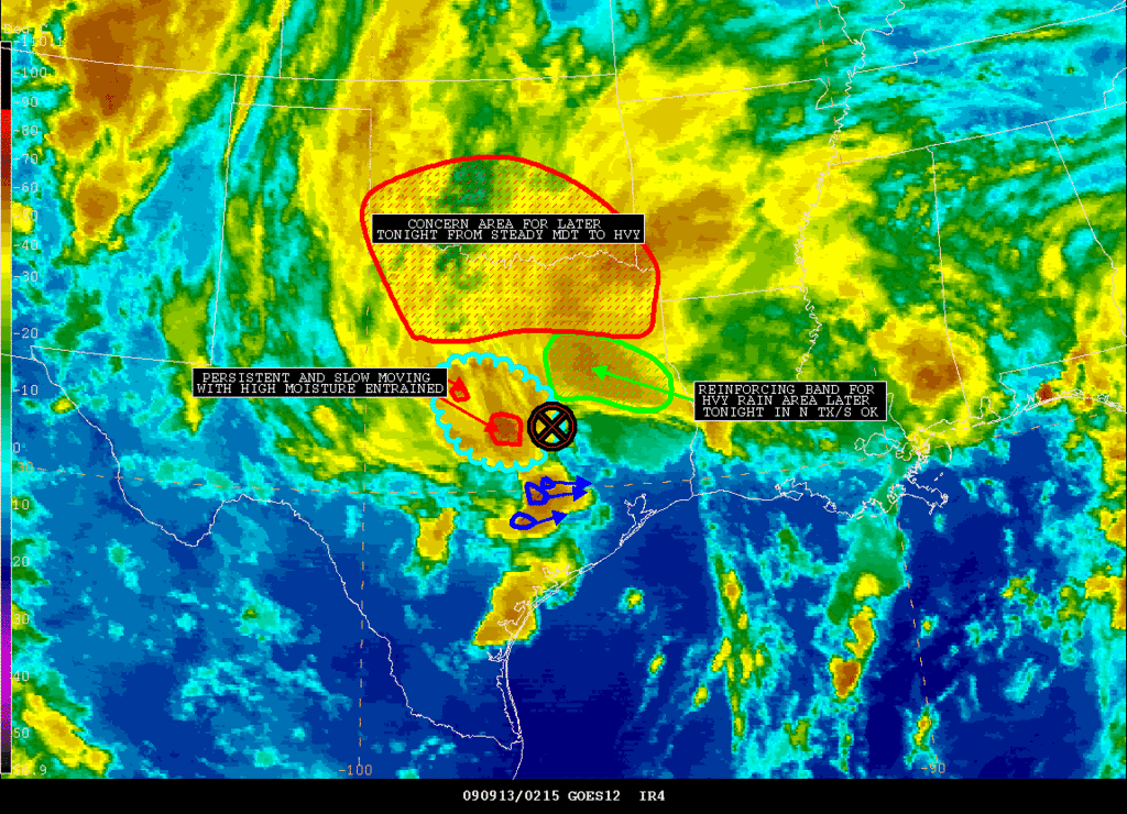
WATER VAPOR IMAGERY AND REGIONAL RADARS SHOW BROAD UPPER LEVEL
LOW CIRCULATION OVER C TX TONIGHT. ONLY ISO SHOWERS REMAIN OVER
SE TX IF ANY WITH STRONGER ACTIVITY WEST OF THE REGION. BACKED
OFF POPS A LITTLE BIT GIVEN THE RELATIVELY DRY TREND WHICH MAY OR
MAY NOT CONTINUE. THE MAIN CONCERN WILL BE IF THE UPPER LOW MOVES
TO THE EAST LATER TONIGHT INTO SUN MORNING. THIS MAY ALLOW FOR
JET STREAKS ON THE BACK SIDE OF THE LOW TO ROTATE THROUGH AND
KICK OFF STRONGER CONVECTION. POPS AROUND 50 PERCENT LOOK
REASONABLE FOR NOW BUT MAY BUMP UP HIGHER SHOULD MORE NUMEROUS
ACTIVITY DEVELOP OUT WEST AND BEGIN TO MOVE INTO SE TX.
OTHERWISE
THINK SE TX WILL SEE LIGHT SHOWERS WITH ONLY ISO THUNDERSTORMS.
THE REST OF THE FORECAST LOOKS GOOD FOR NOW BUT HINGES ON THE
EVOLUTION OF THIS UPPER LOW.
UPDATED FORECAST PRODUCTS HAVE BEEN
ISSUED.
0 likes   

User avatar
srainhoutx
S2K Supporter
S2K Supporter
Posts: 6919
Age: 67
Joined: Sun Jan 14, 2007 11:34 am
Location: Haywood County, NC
Contact:

Re: SE TX/SW LA weather: Flood Potential

#3806 Postby srainhoutx » Sat Sep 12, 2009 9:10 pm

ULL is getting closer to SE TX...

FLOOD ADVISORY
NATIONAL WEATHER SERVICE HOUSTON/GALVESTON TX
904 PM CDT SAT SEP 12 2009

TXC089-130400-
/O.NEW.KHGX.FA.Y.0047.090913T0204Z-090913T0400Z/
/00000.N.ER.000000T0000Z.000000T0000Z.000000T0000Z.OO/
COLORADO TX-
904 PM CDT SAT SEP 12 2009

THE NATIONAL WEATHER SERVICE IN LEAGUE CITY HAS ISSUED AN

* URBAN AND SMALL STREAM FLOOD ADVISORY FOR...
NORTHWESTERN COLORADO COUNTY IN SOUTHEAST TEXAS...

* UNTIL 1100 PM CDT

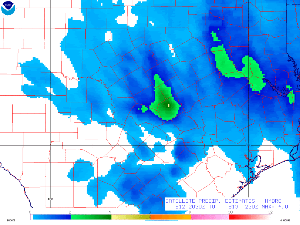
* AT 902 PM CDT...NATIONAL WEATHER SERVICE DOPPLER RADAR INDICATED
VERY HEAVY RAIN WAS FALLING 6 MILES NORTHEAST OF WEIMAR. 1.5 INCHES
OF RAIN HAS FALLEN OVER NORTHWEST COLORADO COUNTY SINCE 845 PM. IF
TRAINING OF CELLS DEVELOPS...A FLOOD WARNING WILL BE ISSUED. AREAS
NORTH OF I-10 COULD RECEIVE UP TO 4 INCHES OF RAIN BY MIDNIGHT.


EDIT to add WV Loop. Notice the shortwave E of Del Rio moving under the ULL. :wink:

http://adds.aviationweather.noaa.gov/sa ... g&itype=wv
0 likes   

User avatar
vbhoutex
Storm2k Executive
Storm2k Executive
Posts: 29113
Age: 73
Joined: Wed Oct 09, 2002 11:31 pm
Location: Cypress, TX
Contact:

Re: SE TX/SW LA weather: Flood Potential

#3807 Postby vbhoutex » Sat Sep 12, 2009 9:41 pm

Guess I'm going to be up for a while longer than I thought. I am not liking the look of the stuff off to the west. Plenty of moisture moving in. Hopefully what I am seeing is those storms decaying that are west of Houston. Gee, just what we needed-a shortwave coming across to trigger the moisture release. We do need the rain, but I don't like hearing about 4" in an area before midnight this late in the evening.
0 likes   

User avatar
srainhoutx
S2K Supporter
S2K Supporter
Posts: 6919
Age: 67
Joined: Sun Jan 14, 2007 11:34 am
Location: Haywood County, NC
Contact:

Re: SE TX/SW LA weather: Flood Potential

#3808 Postby srainhoutx » Sat Sep 12, 2009 9:45 pm

I hear you David. :lol: Things are getting a little more interesting...

BULLETIN - EAS ACTIVATION REQUESTED
FLASH FLOOD WARNING
NATIONAL WEATHER SERVICE HOUSTON/GALVESTON TX
938 PM CDT SAT SEP 12 2009

THE NATIONAL WEATHER SERVICE IN LEAGUE CITY HAS ISSUED A

* FLASH FLOOD WARNING FOR...
NORTHWESTERN COLORADO COUNTY IN SOUTHEAST TEXAS...

* UNTIL 1230 AM CDT

* AT 934 PM CDT...NATIONAL WEATHER SERVICE DOPPLER RADAR INDICATED
THAT FLASH FLOODING WAS LIKELY FROM A THUNDERSTORM 7 MILES SOUTH OF
WEIMAR. 2 TO 3 INCHES OF RAIN HAS FALLEN IN THE LAST HOUR AND
CELLS HAD BEGUN TO TRAIN OVER THE WARNED AREA. ANOTHER 1 TO 3
INCHES OF RAIN WILL BE POSSIBLE BY MIDNIGHT.
FLOODING IS POSSIBLE
AND MOTORISTS SHOULD USE EXTREME CAUTION IF DRIVING TONIGHT.

* LOCATIONS IN THE FLOOD WARNING INCLUDE BUT ARE NOT LIMITED TO
WEIMER AND FRELSBURG.
0 likes   

User avatar
Diva
S2K Supporter
S2K Supporter
Posts: 205
Joined: Fri Jun 16, 2006 11:46 am
Location: Orange, TX

#3809 Postby Diva » Sat Sep 12, 2009 10:11 pm

WOW! 2-3 inches in the last hour?....and more on the way? :double: Hope everyone stays safe out there tonight.

It looks like our rain has stopped for now. It drizzled all day with periods of heavier showers. But certainly not the inches and inches that we had expected.

OT - Oh, and I like this thread much better than the thread in the "Talkin' Tropics" section. That thread is scary! :eek: I think the admins should put a big orange circle around that thread and watch for dangerous development! :lol:
0 likes   

User avatar
srainhoutx
S2K Supporter
S2K Supporter
Posts: 6919
Age: 67
Joined: Sun Jan 14, 2007 11:34 am
Location: Haywood County, NC
Contact:

Re: SE TX/SW LA weather: Flood Potential

#3810 Postby srainhoutx » Sat Sep 12, 2009 10:16 pm

FWD (Ft Worth/Dallas) just issued this update for Bell/Milam County (just N and W of Bryan/College Station)...

AREA FORECAST DISCUSSION...UPDATED
NATIONAL WEATHER SERVICE FORT WORTH TX
1008 PM CDT SAT SEP 12 2009

.UPDATE...
CONTINUOUS LATE TO MODERATE RAIN SHOULD VERIFY CATEGORICAL POPS
NEARLY EVERYWHERE. LIGHTNING IS LIMITED TO CONVECTION IN CENTRAL
AND SOUTH TEXAS...AND WILL CARRY ONLY ISOLATED THUNDER OVERNIGHT.
VORT CENTER NEAR BELL/MILAM PRODUCING MODERATE RAIN ON AREAS THAT
HAVE ALREADY BEEN INUNDATED. WILL NEED TO WATCH AREA CLOSELY FOR
NOCTURNAL CORE RAINS
...WHICH WOULD AGGRAVATE FLOODING ISSUES.
Last edited by srainhoutx on Sat Sep 12, 2009 10:20 pm, edited 1 time in total.
0 likes   

User avatar
southerngale
Retired Staff
Retired Staff
Posts: 27418
Joined: Thu Oct 10, 2002 1:27 am
Location: Southeast Texas (Beaumont area)

Re:

#3811 Postby southerngale » Sat Sep 12, 2009 10:18 pm

Diva wrote:WOW! 2-3 inches in the last hour?....and more on the way? :double: Hope everyone stays safe out there tonight.

It looks like our rain has stopped for now. It drizzled all day with periods of heavier showers. But certainly not the inches and inches that we had expected.

OT - Oh, and I like this thread much better than the thread in the "Talkin' Tropics" section. That thread is scary! :eek: I think the admins should put a big orange circle around that thread and watch for dangerous development! :lol:

:lol:
0 likes   

User avatar
southerngale
Retired Staff
Retired Staff
Posts: 27418
Joined: Thu Oct 10, 2002 1:27 am
Location: Southeast Texas (Beaumont area)

#3812 Postby southerngale » Sat Sep 12, 2009 10:19 pm

:( Those poor guys dealing with flooding rains... if only there was a way for them to share and we'd all get enough to be happy and nobody would flood.

If only I could control the weather...
0 likes   

User avatar
vbhoutex
Storm2k Executive
Storm2k Executive
Posts: 29113
Age: 73
Joined: Wed Oct 09, 2002 11:31 pm
Location: Cypress, TX
Contact:

Re:

#3813 Postby vbhoutex » Sat Sep 12, 2009 10:21 pm

southerngale wrote::( Those poor guys dealing with flooding rains... if only there was a way for them to share and we'd all get enough to be happy and nobody would flood.

If only I could control the weather...
That would be awesome because then we would have snow at least once every winter!!! :froze: :spam: :cheesy:
0 likes   

User avatar
Ptarmigan
Category 5
Category 5
Posts: 5313
Joined: Wed Aug 16, 2006 9:06 pm

Re: SE TX/SW LA weather: Flood Potential

#3814 Postby Ptarmigan » Sat Sep 12, 2009 10:52 pm

Hope that storm west of here holds up, so we get the rain. :wink: That storm is not moving fast. It is moving slowly, which means heavier rain. That could be a problem. :(
0 likes   

User avatar
srainhoutx
S2K Supporter
S2K Supporter
Posts: 6919
Age: 67
Joined: Sun Jan 14, 2007 11:34 am
Location: Haywood County, NC
Contact:

Re: SE TX/SW LA weather: Flood Potential

#3815 Postby srainhoutx » Sat Sep 12, 2009 10:54 pm

Latest from NESDIS...

SATELLITE PRECIPITATION ESTIMATES..DATE/TIME 09/13/09 0257Z
SATELLITE ANALYSIS BRANCH/NESDIS---NPPU---TEL.301-763-8678
LATEST DATA USED: GOES-12 0245Z
.
LOCATION...TEXAS...OKLAHOMA...
.
ATTN WFOS...SHV...TSA...HGX...FWD...OUN...EWX...SJT...LUB...
ATTN RFCS...LMRFC...ABRFC...WGRFC...
.
EVENT...DEEP MOISTURE IN LOW AND WARM OVERSHOOTING TOPS FOR SMALL AREA
OF EXCESSIVE CONTINUING...LONGER TERM FLOOD PROSPECTS FURTHER NORTH...
.
SATELLITE ANALYSIS AND TRENDS...UPPER LEVEL VORT WITH ENTRAINED DEEP
MOISTURE NOW CENTERED ROBERTSON COUNTY. PIVOT BAND ON EAST SIDE LIFTING
NORTH THRU E CENTRAL TEXAS AND WILL MOST LIKELY BE THE REINFORCER FOR
ADDITIONAL MODERATE TO HVY RAIN BAND INTO N CENTRAL
TO INTERIOR NW TX INTO S CENTRAL OK OVERNIGHT. BUT STILL OF IMMEDIATE
CONCERN IS ENHANCEMENT FROM PIVOT OF VORT WEST AND NW AND ESPECIALLY
AREAS OF COOLER TOPS INDICATING EXCESSIVE RAINS. DEEP MOISTURE OF 2.0"
OR SLIGHTLY GREATER ENTRAINED AND VERY EFFICIENTLY PRODUCING HVY RAIN
AMOUNTS OVER A RELATIVELY SMALL AREA BUT THIS JUST HAPPENS TO BE AN AREA
THAT GOT HVY RAIN EARLIER THIS AFTERNOON. MILIAM COUNTY APPEARS NOW TO
BE THE CENTER OF THE ACTION WITH MOST PERSISTENT COLDEST CLOUD TOPS AND
SURROUNDING AREAS JUST TO THE WEST AND NW IN WILLIAMSON AND BELL COUNTY.
ALSO NOTED WAS HAMILTON COUNTY COOLING OVERSHOOTING CLOUD TOPS BUT THAT
AREA HAS NOT BEEN QUITE AS PERSISTENT AS CONVECTION TO THE SE OF THERE.
FURTHER NORTH...EXPECTING MORE OF A LONG TERM STEADY MODERATE/OCCASION
HVY RAIN EVENT ACROSS N CENTRAL TO INTERIOR NW TX AND ON INTO
S CENTRAL OK UNTIL VORT AND REINFORCING COMMA BAND ACROSS E TX CAN
START FOCUSING HIGHER RAIN AMOUNTS INTO THE AREA POSSIBLY LATER TONIGHT.
WILL CONTINUE TO MONITOR...
SATELLITE ESTIMATE GRAPHIC FOR THE 6HR PERIOD ENDING 0230Z WITH A MAX
OF 4.0" CENTERED IN MILAM COUNTY (PRETTY GOOD FOR A WARM TOP EVENT)
AND SATELLITE ANALYSIS GRAPHIC WILL SHORTLY BE POSTED TO OUR WEB PAGE
ADDRESS BELOW...
.
SEE NCEP HPC DISCUSSION AND QPF/S FOR FORECAST.
....NESDIS IS A MEMBER OF 12 PLANET....
.
SSD/SAB WEB ADDRESS FOR PRECIP ESTIMATES:
HTTP://WWW.SSD.NOAA.GOV/PS/PCPN/
...ALL LOWER CASE EXCEPT /PS/PCPN/


Image

Image
0 likes   

User avatar
Ptarmigan
Category 5
Category 5
Posts: 5313
Joined: Wed Aug 16, 2006 9:06 pm

Re: SE TX/SW LA weather: Flood Potential

#3816 Postby Ptarmigan » Sat Sep 12, 2009 11:08 pm

srainhoutx wrote:FWD (Ft Worth/Dallas) just issued this update for Bell/Milam County (just N and W of Bryan/College Station)...

AREA FORECAST DISCUSSION...UPDATED
NATIONAL WEATHER SERVICE FORT WORTH TX
1008 PM CDT SAT SEP 12 2009

.UPDATE...
CONTINUOUS LATE TO MODERATE RAIN SHOULD VERIFY CATEGORICAL POPS
NEARLY EVERYWHERE. LIGHTNING IS LIMITED TO CONVECTION IN CENTRAL
AND SOUTH TEXAS...AND WILL CARRY ONLY ISOLATED THUNDER OVERNIGHT.
VORT CENTER NEAR BELL/MILAM PRODUCING MODERATE RAIN ON AREAS THAT
HAVE ALREADY BEEN INUNDATED. WILL NEED TO WATCH AREA CLOSELY FOR
NOCTURNAL CORE RAINS
...WHICH WOULD AGGRAVATE FLOODING ISSUES.


Core rains could be a problem and I see what could be them west of here.
0 likes   

User avatar
southerngale
Retired Staff
Retired Staff
Posts: 27418
Joined: Thu Oct 10, 2002 1:27 am
Location: Southeast Texas (Beaumont area)

Re: Re:

#3817 Postby southerngale » Sat Sep 12, 2009 11:10 pm

vbhoutex wrote:
southerngale wrote::( Those poor guys dealing with flooding rains... if only there was a way for them to share and we'd all get enough to be happy and nobody would flood.

If only I could control the weather...
That would be awesome because then we would have snow at least once every winter!!! :froze: :spam: :cheesy:


LOL! You got that right! Image
0 likes   

User avatar
jasons2k
Storm2k Executive
Storm2k Executive
Posts: 8245
Age: 51
Joined: Wed Jul 06, 2005 12:32 pm
Location: The Woodlands, TX

#3818 Postby jasons2k » Sat Sep 12, 2009 11:15 pm

The area to our W/SW has the coldest cloud tops in the whole system, and it's expanding:

http://adds.aviationweather.noaa.gov/sa ... g&itype=ir
0 likes   

User avatar
srainhoutx
S2K Supporter
S2K Supporter
Posts: 6919
Age: 67
Joined: Sun Jan 14, 2007 11:34 am
Location: Haywood County, NC
Contact:

Re: SE TX/SW LA weather: Flood Potential

#3819 Postby srainhoutx » Sat Sep 12, 2009 11:20 pm

I posted this "locally", but well worth repeating here as well. It has perked my ears, Jason. :wink:

Keep an eye on radar as well as WV/IR Imagery. Cooling cloud tops to our W is worrisome. Remember this Upper Level Low has had a long history of nocternal events. We may be seeing the beginning of a core event just to our W.

WV...

http://adds.aviationweather.noaa.gov/sa ... g&itype=wv

IR...

http://adds.aviationweather.noaa.gov/sa ... g&itype=ir
0 likes   

User avatar
vbhoutex
Storm2k Executive
Storm2k Executive
Posts: 29113
Age: 73
Joined: Wed Oct 09, 2002 11:31 pm
Location: Cypress, TX
Contact:

Re: SE TX/SW LA weather: Flood Potential

#3820 Postby vbhoutex » Sat Sep 12, 2009 11:29 pm

srainhoutx wrote:I posted this "locally", but well worth repeating here as well. It has perked my ears, Jason. :wink:

Keep an eye on radar as well as WV/IR Imagery. Cooling cloud tops to our W is worrisome. Remember this Upper Level Low has had a long history of nocternal events. We may be seeing the beginning of a core event just to our W.

WV...

http://adds.aviationweather.noaa.gov/sa ... g&itype=wv

IR...

http://adds.aviationweather.noaa.gov/sa ... g&itype=ir

Gonna have to watch some more before I hit the sack. This is definitely troubling and just what we talked about a little while ago. Hopefully all we will see is some heavy rain and not a core event.
0 likes   


Return to “USA & Caribbean Weather”

Who is online

Users browsing this forum: wxman22 and 20 guests