BULLETIN - EAS ACTIVATION REQUESTED
FLASH FLOOD WARNING
NATIONAL WEATHER SERVICE HOUSTON/GALVESTON TX
425 PM CDT THU OCT 1 2009
THE NATIONAL WEATHER SERVICE IN LEAGUE CITY HAS ISSUED A
* FLASH FLOOD WARNING FOR...
NORTHERN GALVESTON COUNTY IN SOUTHEAST TEXAS...
* UNTIL 515 PM CDT
* AT 421 PM CDT...LOCAL LAW ENFORCEMENT OFFICIALS REPORTED FLASH
FLOODING WAS OCCURRING IN NORTHERN GALVESTON COUNTY IN AND AROUND THE
LEAGUE CITY AREA. NEARLY STATIONARY SHOWERS AND THUNDERSTORMS
CONTAINING VERY HEAVY RAINFALL RATES OF 2 TO 4 INCHES PER HOUR
CONTINUE ACROSS PORTIONS OF NORTHERN GALVESTON COUNTY AND ARE LIKELY
CAUSING FLOODING.
* LOCATIONS IN THE FLOOD WARNING INCLUDE BUT ARE NOT LIMITED TO
KEMAH...DICKINSON...LEAGUE CITY AND BACLIFF.
SE TX/SW LA weather: Much cooler and WET after Tuesday
Moderator: S2k Moderators
Forum rules

The posts in this forum are NOT official forecast and should not be used as such. They are just the opinion of the poster and may or may not be backed by sound meteorological data. They are NOT endorsed by any professional institution or STORM2K.
-
srainhoutx

- S2K Supporter

- Posts: 6919
- Age: 68
- Joined: Sun Jan 14, 2007 11:34 am
- Location: Haywood County, NC
- Contact:
Re: SE TX/SW LA weather: A fall-like pattern?
0 likes
Carla/Alicia/Jerry(In The Eye)/Michelle/Charley/Ivan/Dennis/Katrina/Rita/Wilma/Ike/Harvey
Member: National Weather Association
Wx Infinity Forums
http://wxinfinity.com/index.php
Facebook.com/WeatherInfinity
Twitter @WeatherInfinity
Member: National Weather Association
Wx Infinity Forums
http://wxinfinity.com/index.php
Facebook.com/WeatherInfinity
Twitter @WeatherInfinity
-
srainhoutx
- S2K Supporter
- Posts: 6919
- Age: 68
- Joined: Sun Jan 14, 2007 11:34 am
- Location: Haywood County, NC
- Contact:
Re: SE TX/SW LA weather: A fall-like pattern?
PRELIMINARY LOCAL STORM REPORT
NATIONAL WEATHER SERVICE HOUSTON/GALVESTON TX
451 PM CDT THU OCT 01 2009
..TIME... ...EVENT... ...CITY LOCATION... ...LAT.LON...
..DATE... ....MAG.... ..COUNTY LOCATION..ST.. ...SOURCE....
..REMARKS..
0449 PM FLOOD LEAGUE CITY 29.49N 95.11W
10/01/2009 GALVESTON TX LAW ENFORCEMENT
NUMEROUS ROADS ARE FLOODED AROUND LEAGUE CITY.
0 likes
Carla/Alicia/Jerry(In The Eye)/Michelle/Charley/Ivan/Dennis/Katrina/Rita/Wilma/Ike/Harvey
Member: National Weather Association
Wx Infinity Forums
http://wxinfinity.com/index.php
Facebook.com/WeatherInfinity
Twitter @WeatherInfinity
Member: National Weather Association
Wx Infinity Forums
http://wxinfinity.com/index.php
Facebook.com/WeatherInfinity
Twitter @WeatherInfinity
-
jasons2k

- Storm2k Executive

- Posts: 8290
- Age: 52
- Joined: Wed Jul 06, 2005 12:32 pm
- Location: The Woodlands, TX
AREA FORECAST DISCUSSION
NATIONAL WEATHER SERVICE HOUSTON/GALVESTON TX
908 PM CDT THU OCT 1 2009
.DISCUSSION...
SHOWERS AND THUNDERSTORMS...SOME SEVERE...CONTINUE TO DEVELOP ALONG
AND AHEAD OF THE COLD FRONT APPROACHING SOUTHEAST TEXAS FROM THE NORTHWEST.
PREVIOUS TIMING OF THE FRONT AND ASSOCIATED RISK OF SHOWERS AND THUNDERSTORMS
(SOME POSSIBLY SEVERE AS DEPICTED BY THE 01Z SPC DAY 1 CONVECTIVE OUTLOOK)
IN EARLIER DISCUSSIONS STILL LOOKS GOOD...AND NO FORECAST UPDATE IS
NEEDED AT THIS TIME.
A SMALL AREA OF SHOWERS AND THUNDERSTORMS FORMED AND TRAINED DURING
THE MID TO LATE AFTERNOON HOURS ACROSS FAR NORTHERN GALVESTON COUNTY
AND GENERATED A LOT OF RAIN. HARRIS COUNTY OEM RAIN GAGES RECORDED
RAINFALL TOTALS BETWEEN 2 AND ALMOST 5.50 INCHES IN AND AROUND THE
LEAGUE CITY AREA WHICH PRODUCED FLOODING. SOME HIGHER TOTALS PROBABLY
OCCURRED...WITH AN UNOFFICIAL REPORT OF 7 INCHES RECEIVED FROM THE
LOCAL MEDIA.
0 likes
-
jasons2k
- Storm2k Executive
- Posts: 8290
- Age: 52
- Joined: Wed Jul 06, 2005 12:32 pm
- Location: The Woodlands, TX
MESOSCALE DISCUSSION 2058
NWS STORM PREDICTION CENTER NORMAN OK
0944 PM CDT THU OCT 01 2009
AREAS AFFECTED...CENTRAL/SCENTRAL INTO SERN TX
CONCERNING...SEVERE POTENTIAL...WATCH UNLIKELY
VALID 020244Z - 020415Z
AN ISOLATED SEVERE WEATHER THREAT WILL LIKELY SHIFT SWD OUT OF WW
752 INTO PORTIONS OF CENTRAL/SCENTRAL-SERN TX DURING THE NIGHT. AT
THIS TIME...AN ADDITIONAL WW DOES NOT APPEAR NECESSARY.
SCATTERED THUNDERSTORMS CONTINUE TO FORM ALONG AND AHEAD OF A S-SEWD
MOVING COLD FRONT. ACTIVITY OCCURRING IN FRONT OF THE BOUNDARY HAS
REMAINED SOMEWHAT DISCRETE AND DISPLAYS OCCASIONAL SUPERCELL
CHARACTERISTICS...WHILE ACTIVITY OCCURRING ON THE FRONT IS TAKING ON
MORE OF A BROKEN QUASI-LINEAR MODE. MOIST SSWLY LOW LEVEL FLOW WILL
LIKELY CONTINUE TO MAINTAIN STORM DEVELOPMENT DURING THE NIGHT AS
THE FRONT MOVES SWD ACROSS CENTRAL AND SERN TX...AND VERTICAL WIND
SHEAR WILL FAVOR ORGANIZED THUNDERSTORM DEVELOPMENT...INCLUDING LINE
SEGMENTS AND SHORT LIVED SUPERCELLS. THESE STORMS MAY POSE AN
ISOLATED RISK OF LARGE HAIL AND DAMAGING WIND GUSTS DURING THE
NIGHT. HOWEVER...STRONGEST LARGE SCALE ASCENT CONTINUES TO MOVE AWAY
FROM THE REGION...WHICH SUGGESTS THAT THE PROBABILITY FOR AN
ORGANIZED NOCTURNAL SEVERE WEATHER EVENT IS WANING.
0 likes


Re: SE TX/SW LA weather: A fall-like pattern?
I have heard on the news that the storms could be here around 3 AM.
0 likes
-
srainhoutx
- S2K Supporter
- Posts: 6919
- Age: 68
- Joined: Sun Jan 14, 2007 11:34 am
- Location: Haywood County, NC
- Contact:
Re: SE TX/SW LA weather: A fall-like pattern?
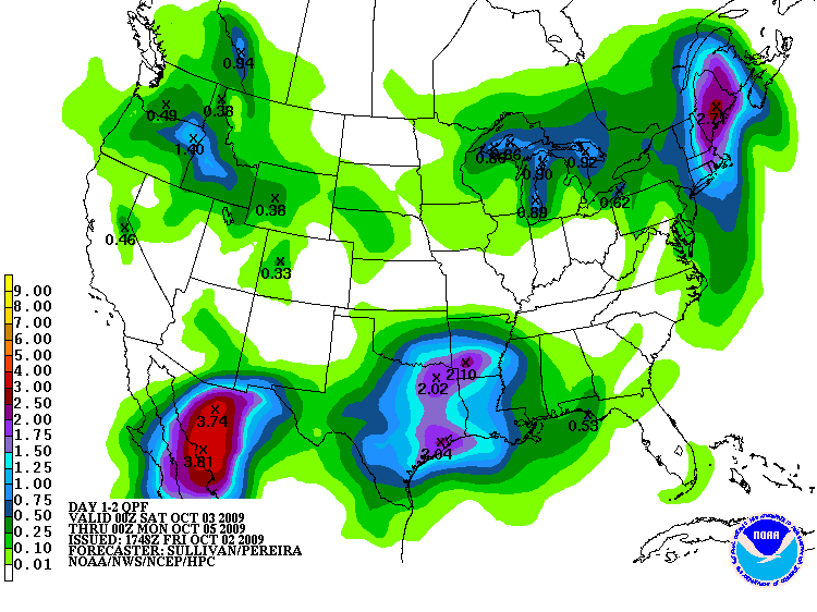
Nice morning behind the squall line and front with temps in th 60's and dewpoints in the mid 50's. The real fun begins tomorrow through Sunday and Olaf appears a bit stronger than many suspected. HPC QPF disco continues to advertise a mess for the weekend...snipet...
...CNTRL/SRN TX AND WRN/CNTRL GULF COAST...
EXPECT THERE TO BE AN EXPANDING AXIS OF MDT TO HVY WARM ADVECTION
RAINS ALONG WITH EMBEDDED STRONGER CONVECTION AS A MID LVL TROF
EMBEDDED IN THE SUBTROPICAL JET ACROSS MEXICO EJECTS ENEWD ACROSS
THE RIO GRANDE AND INTO S CNTRL TX. THE ENERGY SHOULD INTERACT
WITH THE TAIL END OF AN OLD COLD FRONT ALONG WITH A SIGNIFICANT
AMOUNT OF TROPICAL MOISTURE POOLED ALONG IT. THE AFOREMENTIONED
FRONT SHOULD LIFT GRADUALLY NORTH AS A WARM FRONT...AND AS VERY
MOIST SRLY ONSHORE FLOW CONTINUES...THE AREA OF PCPN SHOULD EXPAND
WITH TIME ACROSS TX AND THEN MOVE EASTWARD THROUGHOUT THE LWR MS
VLY AND INTO THE CNTRL GULF COAST STATES. THERE CONTINUES TO BE
SOME SPREAD WITH THE TIMING OF THE EASTWARD ADVANCE OF PCPN..BUT
WITH STG W/SWLY MID/UPR LVL FLOW AND SOME FASTER TRENDS SEEN IN
THE 00Z GFS/ECMWF WITH THE MSTR TRANSPORT..OPTED TO LEAN TWD THE
RELATIVELY MORE PROGRESSIVE CONSENSUS.
Morning e-mail from Jeff echoes the concerns
Noisy morning as cold front pushed a linear cluster of storms through most of the area.
Storms have for the most part cleared the coast with the exception being over Brazoria, Matagorda and Jackson counties. Many areas picked up a quick 1-2 inches of rain with this line. Locations in northern Galveston/southern Harris that saw 3-4 inches yesterday afternoon and 1-2 inches this morning have netted 4-6 inches in the last 24 hours. Skies will clear from NW to SE this morning as drier air filters in behind the frontal passage….however moisture comes roaring back early Saturday setting the stage for a stormy weekend.
Upper air pattern shows a large storm system over the Midwest with the trailing cold front moving off the TX coast. Sub-tropical jet is evident arching across Baja into central Mexico and nearly SW TX. SW of Baja well defined TS Olaf is supplying a good moisture tap via the sub-tropical jet into central Mexico. Brief stint of WNW dry flow will become SW flow with time over the next 24 hours allowing Olaf’s moisture to surge into the area from the SW. Closer to the surface…the frontal boundary will stall off the coast and then begin to return northward as a warm front while deep tropical moisture from the western Gulf overruns the boundary. Disturbances flowing out of Olaf and caught in the SW flow aloft will add additional lift across the area and when combined with the stalled/slow moving surface boundary and deep moisture levels widespread thunderstorms and heavy rainfall appear likely.
Will go with the slightly slower return of the rains and hold them off until at least noon Saturday for most areas, although SW area including Matagorda Bay region may get wet prior to sunrise Saturday. First short wave will bring the first round across the region from the SW Saturday afternoon into Saturday night. Will be watching the returning warm front and this is where the heaviest activity will tend to focus. Next impulse (possibly Olaf’s remains) will move across on Sunday. Warm front may be north of the area by this time with low level forcing largely absent however models are pounding away at widespread rains on Sunday. With the same line of thinking, the models may be trying to return the warm front too fast, it is common for boundaries to get bogged down in such situations which keeps the focus pegged at one area for a long period of time.
Given progged moisture levels increasing to over 200% above normal, favorable upper air venting pattern, surface boundary, and tropical tap influences good rains can be expected. Main question is where the surface warm front hangs out and for how long as to where the heaviest rains will fall and the greatest totals will be. I tending to favor the coastal counties and Matagorda Bay at this time, but really it could be just about anywhere. Widespread 2-4 inches will be common through Sunday evening with isolated totals upwards of 6 inches. Given the now wetter grounds this could result in some run-off problems.
Extended:
Sub-tropical ridge builds into the Gulf early next week with oppressive moisture levels remaining and building mid level heights. Should see afternoon highs well into the 90’s with heat index values nearing 100-105. Increasing capping should help to limit convection to afternoon in nature. Next front pegged for Thursday and this one looks like another messy one with the boundary pulling up stationary again and SW flow overrunning it…El Nino is starting to show its face!
0 likes
Carla/Alicia/Jerry(In The Eye)/Michelle/Charley/Ivan/Dennis/Katrina/Rita/Wilma/Ike/Harvey
Member: National Weather Association
Wx Infinity Forums
http://wxinfinity.com/index.php
Facebook.com/WeatherInfinity
Twitter @WeatherInfinity
Member: National Weather Association
Wx Infinity Forums
http://wxinfinity.com/index.php
Facebook.com/WeatherInfinity
Twitter @WeatherInfinity
-
vbhoutex

- Storm2k Executive
- Posts: 29149
- Age: 74
- Joined: Wed Oct 09, 2002 11:31 pm
- Location: Cypress, TX
- Contact:
Re: SE TX/SW LA weather: A fall-like pattern?
Can 't believe I slept through the storms last night!  I saw them moving in on radar and it looked like they were disappating. When I got up this am the wife is "didn't you hear the storms?, they woke me up." Anyway we got a healthy 1.20" from that round. Jeff's email along with HPC makes it sound like a wet weekend here in SE TX.
0 likes
-
jasons2k
- Storm2k Executive
- Posts: 8290
- Age: 52
- Joined: Wed Jul 06, 2005 12:32 pm
- Location: The Woodlands, TX
I woke up and checked the radar. Radar estimates over 1.5" for me. My rain gauge had 1.04" in it, but I think the reading is contaminated. The wind was blowing the rain almost sideways from the north and the big pine trees are not far at all from the gauge.
PS - looks like the spell may be finally broken
PS - looks like the spell may be finally broken
0 likes
Re: SE TX/SW LA weather: A fall-like pattern?
Those thunderstorms last night woke me up around 3 AM. Lots of thunder and rain. Next thing, dead silence. Does anyone notice after a night time thunderstorm, it is all quiet? No sounds from animals or anything.
0 likes
-
srainhoutx
- S2K Supporter
- Posts: 6919
- Age: 68
- Joined: Sun Jan 14, 2007 11:34 am
- Location: Haywood County, NC
- Contact:
Re: SE TX/SW LA weather: A fall-like pattern?
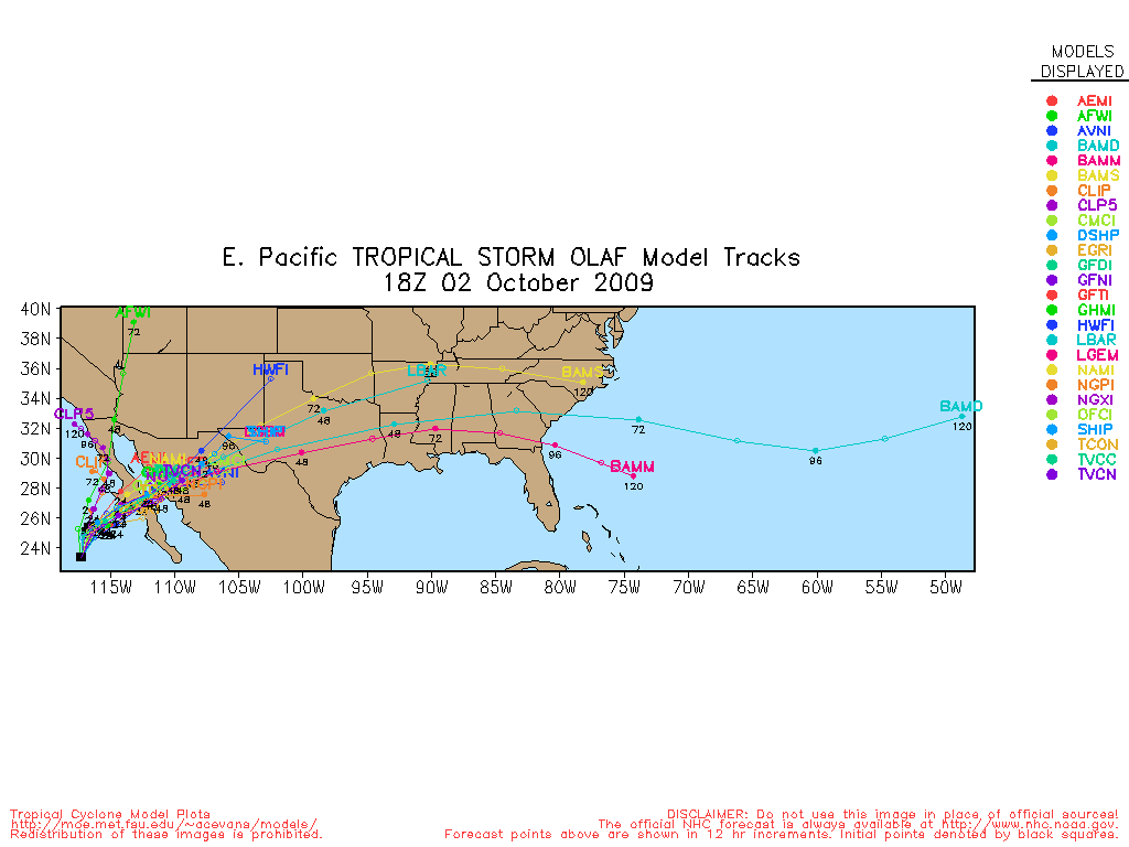
Looking at WV Imagery, Olaf is beginning to feel the effects of the diving Upper Low along the WC and moisture is being thrown E. Olaf should start to turn more ENE in the next several hours and imbedded short waves along N MX will continue to pull moisture into TX.
http://adds.aviationweather.noaa.gov/sa ... g&itype=wv
Latest 1-2 day Updated HPC QPF Totals look reasonable as well.
Edit to add 18Z Track guidance for Olaf...
http://adds.aviationweather.noaa.gov/sa ... g&itype=wv
Latest 1-2 day Updated HPC QPF Totals look reasonable as well.
Edit to add 18Z Track guidance for Olaf...
0 likes
Carla/Alicia/Jerry(In The Eye)/Michelle/Charley/Ivan/Dennis/Katrina/Rita/Wilma/Ike/Harvey
Member: National Weather Association
Wx Infinity Forums
http://wxinfinity.com/index.php
Facebook.com/WeatherInfinity
Twitter @WeatherInfinity
Member: National Weather Association
Wx Infinity Forums
http://wxinfinity.com/index.php
Facebook.com/WeatherInfinity
Twitter @WeatherInfinity

-
jasons2k
- Storm2k Executive
- Posts: 8290
- Age: 52
- Joined: Wed Jul 06, 2005 12:32 pm
- Location: The Woodlands, TX
Re: SE TX/SW LA weather: A fall-like pattern?
Hi Diva - that late in the day, it's not looking good. Rain is already moving this way from the west and SW on the San Antonio & Corpus radars. I would count on the rain moving in by then.
0 likes
-
srainhoutx
- S2K Supporter
- Posts: 6919
- Age: 68
- Joined: Sun Jan 14, 2007 11:34 am
- Location: Haywood County, NC
- Contact:
Re: SE TX/SW LA weather: A fall-like pattern?
Warm front appears to be slowly moving N this morning from just S of Victoria to our SW. Rainfall has started in San Antonio. Guidance was not helpful overnight and HPC echoes this in QPF Update. This event will likely be a nowcast situation as to where heavy rainfall sets up. I still would not be surprised to see some areas see a general 1-3 inches of rainfall with some isolated higher amounts. At this time Central TX may be the winner, but as warm air, PW's and dewpoints increase locally, the same maybe be expected in some parts of our area as well. Regardless, it looks like a rainy preiod ahead.
TD Olaf track will likely be the key in upcoming forecasts. A quick look at track guidance and WV/IR Imagery shows that Olaf concentrated moisture is rather stout and just a bit S of forecast track.
IR Loop
http://adds.aviationweather.noaa.gov/sa ... g&itype=ir
WV Loop
http://adds.aviationweather.noaa.gov/sa ... g&itype=wv
0 likes
Carla/Alicia/Jerry(In The Eye)/Michelle/Charley/Ivan/Dennis/Katrina/Rita/Wilma/Ike/Harvey
Member: National Weather Association
Wx Infinity Forums
http://wxinfinity.com/index.php
Facebook.com/WeatherInfinity
Twitter @WeatherInfinity
Member: National Weather Association
Wx Infinity Forums
http://wxinfinity.com/index.php
Facebook.com/WeatherInfinity
Twitter @WeatherInfinity
Re: SE TX/SW LA weather: A fall-like pattern?
jasons wrote:Hi Diva - that late in the day, it's not looking good. Rain is already moving this way from the west and SW on the San Antonio & Corpus radars. I would count on the rain moving in by then.
Uugghh! That's what I thought.
0 likes
-
srainhoutx
- S2K Supporter
- Posts: 6919
- Age: 68
- Joined: Sun Jan 14, 2007 11:34 am
- Location: Haywood County, NC
- Contact:
Re: SE TX/SW LA weather: Heavy Rainfall Possible
Radar back up and running after repairs for HGX. 
0 likes
Carla/Alicia/Jerry(In The Eye)/Michelle/Charley/Ivan/Dennis/Katrina/Rita/Wilma/Ike/Harvey
Member: National Weather Association
Wx Infinity Forums
http://wxinfinity.com/index.php
Facebook.com/WeatherInfinity
Twitter @WeatherInfinity
Member: National Weather Association
Wx Infinity Forums
http://wxinfinity.com/index.php
Facebook.com/WeatherInfinity
Twitter @WeatherInfinity
-
jasons2k
- Storm2k Executive
- Posts: 8290
- Age: 52
- Joined: Wed Jul 06, 2005 12:32 pm
- Location: The Woodlands, TX
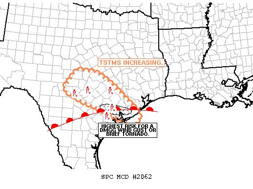
http://www.spc.noaa.gov/products/md/md2062.html
MESOSCALE DISCUSSION 2062
NWS STORM PREDICTION CENTER NORMAN OK
0238 PM CDT SAT OCT 03 2009
AREAS AFFECTED...CNTRL TX TO THE UPR TX CST
CONCERNING...SEVERE POTENTIAL...WATCH UNLIKELY
VALID 031938Z - 032045Z
19Z MESOANALYSIS PLACES A WRMFNT NEAR KCOT-NORTH OF KVCT-SOUTH OF
KGLS. TSTMS HAVE BEEN ON THE INCREASE ALONG/N OF THE FRONT SINCE
LATE MORNING. STORMS SHOULD EXPAND N/NE WITH TIME AS SSWLY H85-H7
WIND FIELDS GRADUALLY STRENGTHEN AHEAD OF A MID-LVL SPEED MAX OVER
SWRN TX. THIS EXPANSION WILL ESPECIALLY BE NOTABLE FROM CNTRL INTO
SERN TX...ALONG THE NRN EDGE WARMING TEMPERATURES ALOFT/ CAPPING.
TSTMS DEVELOPING FROM THE KAUS REGION ENEWD INTO SERN TX WILL LIKELY
BE ROOTED A FEW HUNDRED METERS ABOVE THE SFC PER LATEST RUC
SOUNDINGS. ANY STORM THAT CAN BECOME SUSTAINED CLOSER TO THE WRMFNT
ALONG THE UPR TX CST MAY ROOT LOWER TO THE SFC. IF THIS
OCCURS...EFFECTIVE SHEAR OF 40-45 KTS MAY RESULT IN BRIEF SUPERCELL
STRUCTURES WITH ISOLD DMGG WINDS POSSIBLE. A BRIEF TORNADO CANNOT
BE RULED OUT...THOUGH THE LLVL SELYS ARE SOMEWHAT ANEMIC...RESULTING
IN WEAK 0-1KM SRH.
0 likes
-
srainhoutx
- S2K Supporter
- Posts: 6919
- Age: 68
- Joined: Sun Jan 14, 2007 11:34 am
- Location: Haywood County, NC
- Contact:
Re:
jasons wrote:http://www.spc.noaa.gov/products/md/md2062.html
MESOSCALE DISCUSSION 2062
NWS STORM PREDICTION CENTER NORMAN OK
0238 PM CDT SAT OCT 03 2009
AREAS AFFECTED...CNTRL TX TO THE UPR TX CST
CONCERNING...SEVERE POTENTIAL...WATCH UNLIKELY
VALID 031938Z - 032045Z
19Z MESOANALYSIS PLACES A WRMFNT NEAR KCOT-NORTH OF KVCT-SOUTH OF
KGLS. TSTMS HAVE BEEN ON THE INCREASE ALONG/N OF THE FRONT SINCE
LATE MORNING. STORMS SHOULD EXPAND N/NE WITH TIME AS SSWLY H85-H7
WIND FIELDS GRADUALLY STRENGTHEN AHEAD OF A MID-LVL SPEED MAX OVER
SWRN TX. THIS EXPANSION WILL ESPECIALLY BE NOTABLE FROM CNTRL INTO
SERN TX...ALONG THE NRN EDGE WARMING TEMPERATURES ALOFT/ CAPPING.
TSTMS DEVELOPING FROM THE KAUS REGION ENEWD INTO SERN TX WILL LIKELY
BE ROOTED A FEW HUNDRED METERS ABOVE THE SFC PER LATEST RUC
SOUNDINGS. ANY STORM THAT CAN BECOME SUSTAINED CLOSER TO THE WRMFNT
ALONG THE UPR TX CST MAY ROOT LOWER TO THE SFC. IF THIS
OCCURS...EFFECTIVE SHEAR OF 40-45 KTS MAY RESULT IN BRIEF SUPERCELL
STRUCTURES WITH ISOLD DMGG WINDS POSSIBLE. A BRIEF TORNADO CANNOT
BE RULED OUT...THOUGH THE LLVL SELYS ARE SOMEWHAT ANEMIC...RESULTING
IN WEAK 0-1KM SRH.
0 likes
Carla/Alicia/Jerry(In The Eye)/Michelle/Charley/Ivan/Dennis/Katrina/Rita/Wilma/Ike/Harvey
Member: National Weather Association
Wx Infinity Forums
http://wxinfinity.com/index.php
Facebook.com/WeatherInfinity
Twitter @WeatherInfinity
Member: National Weather Association
Wx Infinity Forums
http://wxinfinity.com/index.php
Facebook.com/WeatherInfinity
Twitter @WeatherInfinity
-
jasons2k
- Storm2k Executive
- Posts: 8290
- Age: 52
- Joined: Wed Jul 06, 2005 12:32 pm
- Location: The Woodlands, TX
BULLETIN - EAS ACTIVATION REQUESTED
TORNADO WARNING
NATIONAL WEATHER SERVICE HOUSTON/GALVESTON TX
307 PM CDT SAT OCT 3 2009
THE NATIONAL WEATHER SERVICE IN LEAGUE CITY HAS ISSUED A
* TORNADO WARNING FOR...
NORTHEASTERN JACKSON COUNTY IN SOUTHEAST TEXAS...
SOUTHWESTERN WHARTON COUNTY IN SOUTHEAST TEXAS...
* UNTIL 345 PM CDT
* AT 307 PM CDT...NATIONAL WEATHER SERVICE DOPPLER RADAR INDICATED A
SEVERE THUNDERSTORM CAPABLE OF PRODUCING A TORNADO THIS TORNADO
WAS LOCATED NEAR GANADO... MOVING EAST AT 15 MPH.
* LOCATIONS IN THE TORNADO WARNING INCLUDE BUT ARE NOT LIMITED TO
LOUISE AND CORDELE.
PLEASE REPORT SEVERE WEATHER TO THE COUNTY SHERIFF...LOCAL POLICE...
OR DEPARTMENT OF PUBLIC SAFETY AND ASK THEM TO RELAY YOUR REPORT TO
THE NATIONAL WEATHER SERVICE.
0 likes
Return to “USA & Caribbean Weather”
Who is online
Users browsing this forum: No registered users and 249 guests