
Multi-day outbreak of May 25-31
Moderator: S2k Moderators
Forum rules

The posts in this forum are NOT official forecast and should not be used as such. They are just the opinion of the poster and may or may not be backed by sound meteorological data. They are NOT endorsed by any professional institution or STORM2K.

-
WeatherGuesser
- Category 5

- Posts: 2672
- Joined: Tue Jun 29, 2010 6:46 am
-
TwisterFanatic

- Category 5
- Posts: 1041
- Joined: Mon Jun 28, 2010 12:43 pm
- Location: Sallisaw, Oklahoma
Amazing how much the atmosphere is conducive to large tornadoes this year.
0 likes
Personal Forecast Disclaimer:
The posts in this forum are NOT official forecast and should not be used as such. They are just the opinion of the poster and may or may not be backed by sound meteorological data. They are NOT endorsed by any professional institution or storm2k.org. For official information, please refer to the NHC and NWS products.
The posts in this forum are NOT official forecast and should not be used as such. They are just the opinion of the poster and may or may not be backed by sound meteorological data. They are NOT endorsed by any professional institution or storm2k.org. For official information, please refer to the NHC and NWS products.
-
apocalypt-flyer
- Category 1

- Posts: 468
- Joined: Sat Aug 27, 2005 11:51 am
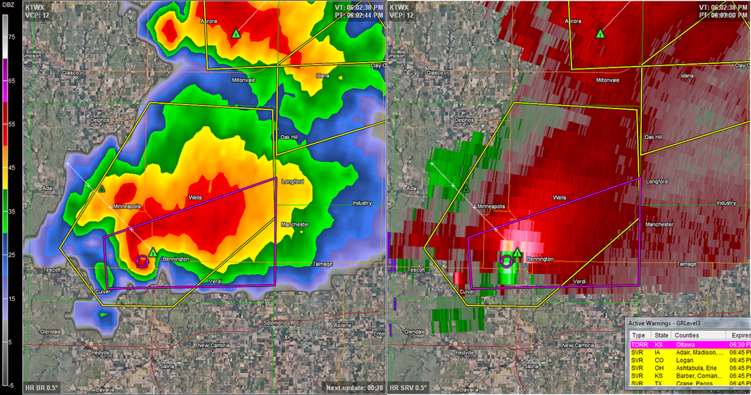
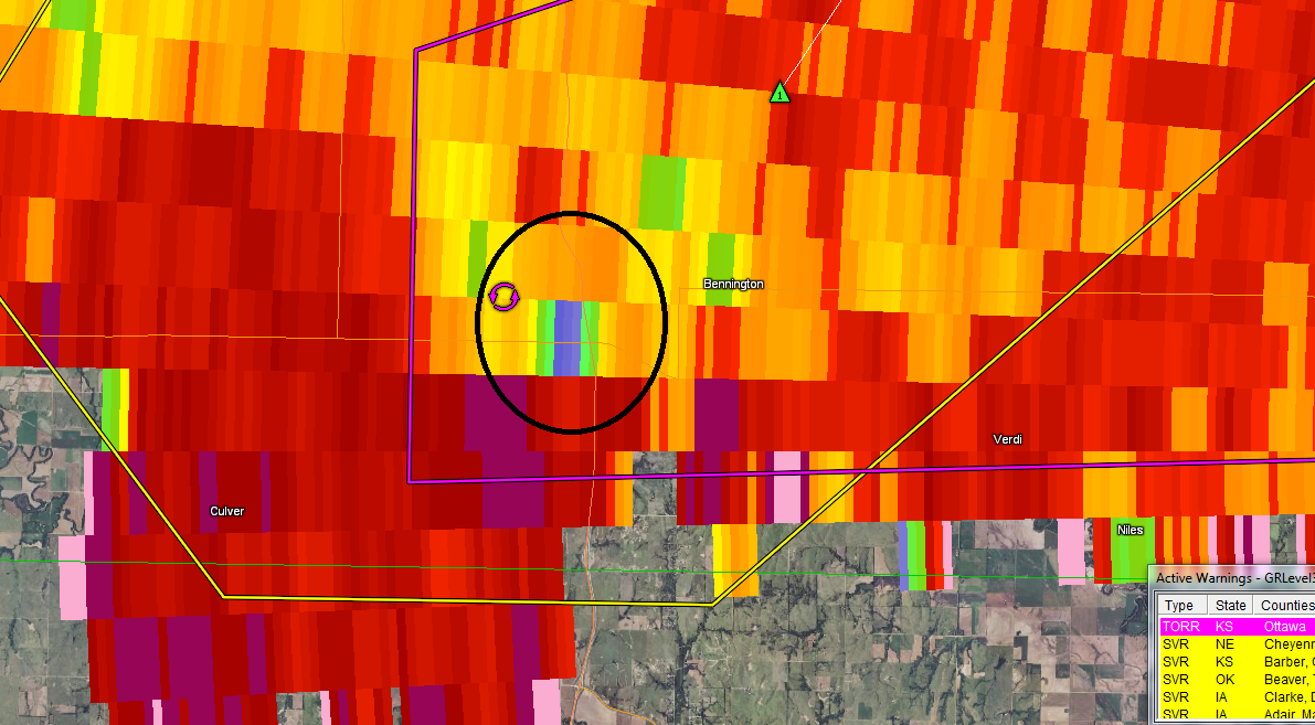
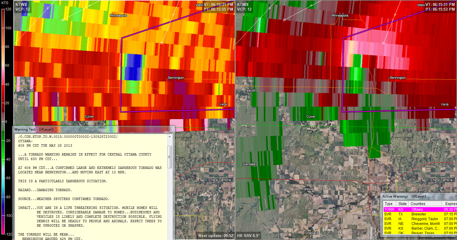
Nearby Bennington, Kansas. From the SevereStudios twitter feed:

Last edited by apocalypt-flyer on Tue May 28, 2013 6:21 pm, edited 1 time in total.
0 likes
-
WeatherGuesser
- Category 5
- Posts: 2672
- Joined: Tue Jun 29, 2010 6:46 am

-
TwisterFanatic
- Category 5
- Posts: 1041
- Joined: Mon Jun 28, 2010 12:43 pm
- Location: Sallisaw, Oklahoma
Re:
RL3AO wrote:I don't see anything unusual. We just know about every large tornado as it happens. In fact, you can probably find streaming video of every strong tornado as it happens now.
It just seems like every storm is dropping huge wedge tornadoes.
0 likes
Personal Forecast Disclaimer:
The posts in this forum are NOT official forecast and should not be used as such. They are just the opinion of the poster and may or may not be backed by sound meteorological data. They are NOT endorsed by any professional institution or storm2k.org. For official information, please refer to the NHC and NWS products.
The posts in this forum are NOT official forecast and should not be used as such. They are just the opinion of the poster and may or may not be backed by sound meteorological data. They are NOT endorsed by any professional institution or storm2k.org. For official information, please refer to the NHC and NWS products.
-
WeatherGuesser
- Category 5
- Posts: 2672
- Joined: Tue Jun 29, 2010 6:46 am
Re:
RL3AO wrote:Looks like the tornado is basically stationary on radar now.
I can't really tell where it's going. It's almost just sitting there spinning a hole in the ground.
0 likes

-
TropicalAnalystwx13

- Category 5
- Posts: 2109
- Age: 28
- Joined: Tue Jul 19, 2011 8:20 pm
- Location: Wilmington, NC
- Contact:
Re:
TwisterFanatic wrote:Amazing how much the atmosphere is conducive to large tornadoes this year.
I've noticed that too. We've not seen a lot of tornadoes this year, but the ones that have formed seem a lot more violent. Seems to be a higher tornado-to-strong-tornado proportion this year.
0 likes
-
TropicalAnalystwx13
- Category 5
- Posts: 2109
- Age: 28
- Joined: Tue Jul 19, 2011 8:20 pm
- Location: Wilmington, NC
- Contact:

-
apocalypt-flyer
- Category 1
- Posts: 468
- Joined: Sat Aug 27, 2005 11:51 am

Return to “USA & Caribbean Weather”
Who is online
Users browsing this forum: CaptinCrunch and 104 guests