
SE TX/SW LA weather: Much cooler and WET after Tuesday
Moderator: S2k Moderators
Forum rules

The posts in this forum are NOT official forecast and should not be used as such. They are just the opinion of the poster and may or may not be backed by sound meteorological data. They are NOT endorsed by any professional institution or STORM2K.
-
srainhoutx

- S2K Supporter

- Posts: 6919
- Age: 68
- Joined: Sun Jan 14, 2007 11:34 am
- Location: Haywood County, NC
- Contact:
Re: SE TX/SW LA weather: Cooler weather
Stay safe neighbors to the E. It wasn't too bad in NW Harris County, but E of I-45 was hit fairly hard. The Pre frontal trough has passed my location and winds hve switched to the NW. Going to feel cold tomorrow and tomorrow night. I suspect the heater will be needed.
0 likes
Carla/Alicia/Jerry(In The Eye)/Michelle/Charley/Ivan/Dennis/Katrina/Rita/Wilma/Ike/Harvey
Member: National Weather Association
Wx Infinity Forums
http://wxinfinity.com/index.php
Facebook.com/WeatherInfinity
Twitter @WeatherInfinity
Member: National Weather Association
Wx Infinity Forums
http://wxinfinity.com/index.php
Facebook.com/WeatherInfinity
Twitter @WeatherInfinity
-
southerngale

- Retired Staff

- Posts: 27418
- Joined: Thu Oct 10, 2002 1:27 am
- Location: Southeast Texas (Beaumont area)
I've been on the phone with my sister, who was driving through this horrible mess. She said this is the worst weather she's ever driven in... scariest driving event of her life. She finally stopped, but she said she couldn't see and she could feel the car lifting and I was checking radar for a tornado. I'm sure it was just the wind. I kept telling her to PULL OVER! I was scared as she sounded quite nervous.
Meanwhile, it's still pouring here and ditches are overflowing into yards. Wow, I really didn't expect this.
Hope you don't have any flooding issues over there, Diva.
Meanwhile, it's still pouring here and ditches are overflowing into yards. Wow, I really didn't expect this.
Hope you don't have any flooding issues over there, Diva.
0 likes
Please support Storm2k by making a donation today. It is greatly appreciated! Click here: 
 my Cowboys my Rockets my Astros
my Cowboys my Rockets my Astros-
southerngale
- Retired Staff
- Posts: 27418
- Joined: Thu Oct 10, 2002 1:27 am
- Location: Southeast Texas (Beaumont area)
Re: SE TX/SW LA weather: Cooler weather
Jefferson and Orange Counties are under a flood warning until noon, and KFDM News has received reports of first responders rescuing people stuck in floodwaters in several parts of the area.
High water is reported at many underpasses along I-10 and along Highway 69, as well as along the Eastex Freeway service road near Lucas. A number of streets are flooded in the Old Town section and other parts of Beaumont. Firefighters say drivers should stay off 11th Street in Beaumont until the floodwaters recede.
Authorities aren't reporting any injuries.
Police and firefighters say if possible you should stay off the roads until the water recedes.
Three inches of rain had fallen between 8:15 and 9:30 a.m. in Beaumont.
Stay with KFDM News for the latest on road conditions.
0 likes
Please support Storm2k by making a donation today. It is greatly appreciated! Click here:
my Cowboys my Rockets my Astros
my Cowboys my Rockets my Astros-
southerngale
- Retired Staff
- Posts: 27418
- Joined: Thu Oct 10, 2002 1:27 am
- Location: Southeast Texas (Beaumont area)
Re: SE TX/SW LA weather: Cooler weather
BULLETIN - EAS ACTIVATION REQUESTED
FLASH FLOOD WARNING
NATIONAL WEATHER SERVICE LAKE CHARLES LA
ISSUED BY NATIONAL WEATHER SERVICE HOUSTON/GALVESTON TX
951 AM CDT THU OCT 22 2009
THE NATIONAL WEATHER SERVICE IN LAKE CHARLES HAS ISSUED A
* FLASH FLOOD WARNING FOR...
JEFFERSON COUNTY IN SOUTHEAST TEXAS...
THIS INCLUDES THE CITY OF SABINE PASS...
NEWTON COUNTY IN SOUTHEAST TEXAS...
THIS INCLUDES THE CITIES OF...TOLEDO BEND DAM...DEWEYVILLE...BON
WEIR...
ORANGE COUNTY IN SOUTHEAST TEXAS...
THIS INCLUDES THE CITIES OF...WEST ORANGE...ORANGE...
BEAUREGARD PARISH IN SOUTHWEST LOUISIANA...
THIS INCLUDES THE CITIES OF...SUGARTOWN...SINGER...RAGLEY...
MERRYVILLE...FIELDS...DRY CREEK...DE RIDDER...
CALCASIEU PARISH IN SOUTHWEST LOUISIANA...
THIS INCLUDES THE CITIES OF...WESTLAKE...VINTON...SULPHUR...
STARKS...MOSS BLUFF...LAKE CHARLES...IOWA...DE QUINCY...
CAMERON PARISH IN SOUTHWEST LOUISIANA...
THIS INCLUDES THE CITIES OF...SABINE NATIONAL WILDLIFE...
ROCKEFELLER WILDLIFE RANGE...LACASSINE NATIONAL WILDLIFE REFUGE...
KLONDIKE...JOHNSON BAYOU...GRAND LAKE...GRAND CHENIER...CAMERON...
VERNON PARISH IN WEST CENTRAL LOUISIANA...
THIS INCLUDES THE CITIES OF...SLAGLE...ROSEPINE...PITKIN...
LEESVILLE...FORT POLK...ANACOCO...
* UNTIL 1245 PM CDT
* AT 948 AM CDT...NATIONAL WEATHER SERVICE DOPPLER RADAR INDICATED
FLASH FLOODING POTENTIAL FROM THUNDERSTORMS ALONG A LINE FROM 19
MILES SOUTHWEST OF TOLEDO BEND DAM TO 9 MILES NORTH OF SABINE PASS
TO SABINE PASS...OR ALONG A LINE EXTENDING FROM 11 MILES WEST OF
BURKEVILLE TO PORT ARTHUR TO SABINE PASS...MOVING NORTHEAST AT 20
MPH.
* OTHER LOCATIONS IN THE WARNING INCLUDE BUT ARE NOT LIMITED TO HOLLY
BEACH...HACKBERRY...CARLYSS...NEW LLANO...LONGVILLE AND GILLIS
EXCESSIVE RUNOFF FROM HEAVY RAINFALL WILL CAUSE FLOODING OF SMALL
CREEKS AND STREAMS...COUNTRY ROADS...AS WELL AS FARMLAND ALONG THE
BANKS OF CREEKS AND STREAMS.
MOST FLOOD DEATHS OCCUR IN AUTOMOBILES. NEVER DRIVE YOUR VEHICLE INTO
AREAS WHERE THE WATER COVERS THE ROADWAY. FLOOD WATERS ARE USUALLY
DEEPER THAN THEY APPEAR. JUST ONE FOOT OF FLOWING WATER IS POWERFUL
ENOUGH TO SWEEP VEHICLES OFF THE ROAD. WHEN ENCOUNTERING FLOODED
ROADS MAKE THE SMART CHOICE...TURN AROUND...DONT DROWN.
LAT...LON 3136 9298 3126 9282 3088 9282 3087 9297
3061 9297 3060 9313 3039 9313 3038 9302
3016 9299 3015 9288 3005 9298 3004 9261
2959 9261 2979 9321 2975 9373 2968 9393
2996 9376 3021 9379 3115 9362 3137 9338
0 likes
Please support Storm2k by making a donation today. It is greatly appreciated! Click here:
my Cowboys my Rockets my Astros
my Cowboys my Rockets my Astros-
southerngale
- Retired Staff
- Posts: 27418
- Joined: Thu Oct 10, 2002 1:27 am
- Location: Southeast Texas (Beaumont area)
Re: SE TX/SW LA weather: Cooler weather
First pics I've seen. These are in Beaumont.
From KFDM, College St. @ MLK

From KBMT:

From KBTV about 9am:


From KFDM, College St. @ MLK
From KBMT:
From KBTV about 9am:
From KBMT
Flooding Rains Create Havoc For Commuters and Emergency Responders
Meteorologist Bryan Rupp
Story Created: Oct 22, 2009 at 10:55 AM CDT
Story Updated: Oct 22, 2009 at 11:01 AM CDT
As day broke across Southeast Texas the heavy rains began pounding large portions of the area. The rains created travel nightmares for many as streets and intersections quickly flooded due to the excessive rainfall.
Many streets in Beaumont, that typically flood in these types of events, remained underwater by the 11 o'clock hour.
The National Weather Service issued multiple Tornado Warnings around SETX and Southwest Louisiana due to rotation detected on multiple radars, including 12 News Pinpoint Doppler, however no damage has been reported as of the 10a.m. hour.
Radars indicate rainfall totals in excess of 4 inches in Jefferson County with a large portion of that falling in one and a half hours.
12 News will have the latest information and weather forecast today on the Midday news at 11:30a.m.
0 likes
Please support Storm2k by making a donation today. It is greatly appreciated! Click here:
my Cowboys my Rockets my Astros
my Cowboys my Rockets my Astros
Re: SE TX/SW LA weather: Cooler weather
.
TORNADO WARNING
NATIONAL WEATHER SERVICE SHREVEPORT LA
1134 AM CDT THU OCT 22 2009
THE NATIONAL WEATHER SERVICE IN SHREVEPORT HAS ISSUED A
* TORNADO WARNING FOR...
WEST CENTRAL NATCHITOCHES PARISH IN NORTHWEST LOUISIANA...
EAST CENTRAL SABINE PARISH IN NORTHWEST LOUISIANA...
* UNTIL 1215 PM CDT
* AT 1134 AM CDT...NATIONAL WEATHER SERVICE METEOROLOGISTS DETECTED A
SEVERE THUNDERSTORM CAPABLE OF PRODUCING A TORNADO 23 MILES
SOUTHWEST OF CAMPTI...OR 17 MILES SOUTHWEST OF NATCHITOCHES...
MOVING NORTHEAST AT 30 MPH.
* OTHER LOCATIONS IN THE WARNING INCLUDE BUT ARE NOT LIMITED TO
SHAMROCK MILL...ROBELINE...HAGEWOOD...ALLEN...POWHATAN AND GRAPPES
BLUFF.
0 likes
Re: SE TX/SW LA weather: Cooler weather
DE SOTO LA-RED RIVER LA-
1124 AM CDT THU OCT 22 2009
...A TORNADO WARNING REMAINS IN EFFECT UNTIL NOON CDT FOR RED RIVER
AND DE SOTO PARISHES...
AT 1122 AM CDT...NATIONAL WEATHER SERVICE DOPPLER RADAR CONTINUED TO
DETECT A TORNADO 4 MILES NORTH OF RAMBIN OR JUST NORTH OF
EVELYN...MOVING NORTHEAST NEAR 25 MPH. THIS TORNADO WILL LIKELY
EFFECT THE TOWNS OF GAHAGAN...CARROL AND THE NORTHERN PORTIONS OF
COUSHATTA. IF YOU LIVE IN THE PATH OF THIS TORNADO...TAKE COVER
IMMEDIATELY.
.
CAMERON LA-
1121 AM CDT THU OCT 22 2009
...A TORNADO WARNING REMAINS IN EFFECT UNTIL 1145 AM CDT FOR EAST
CENTRAL CAMERON PARISH...
AT 1119 AM CDT...NATIONAL WEATHER SERVICE DOPPLER RADAR CONTINUED TO
INDICATE A TORNADO. THIS TORNADO WAS LOCATED 7 MILES SOUTHEAST OF
GRAND CHENIER...MOVING NORTH AT 40 MPH.
THE TORNADO WILL BE NEAR...
RURAL EASTERN CAMERON PARISH AT 1140 AM CDT
TORNADO WARNING
NATIONAL WEATHER SERVICE LAKE CHARLES LA
1109 AM CDT THU OCT 22 2009
THE NATIONAL WEATHER SERVICE IN LAKE CHARLES HAS ISSUED A
* TORNADO WARNING FOR...
EASTERN CALCASIEU PARISH IN SOUTHWEST LOUISIANA...
THIS INCLUDES THE CITIES OF...IOWA...HAYES...
NORTH CENTRAL CAMERON PARISH IN SOUTHWEST LOUISIANA...
THIS INCLUDES THE CITY OF LACASSINE NATIONAL WILDLIFE REFUGE...
JEFFERSON DAVIS PARISH IN SOUTHWEST LOUISIANA...
THIS INCLUDES THE CITIES OF...WELSH...LAKE ARTHUR...JENNINGS...
FENTON...
* UNTIL 1215 PM CDT
* AT 1107 AM CDT...NATIONAL WEATHER SERVICE DOPPLER RADAR WAS
TRACKING TWO TORNADOES...ONE OVER LACASSINE NATIONAL WILDLIFE
REFUGE...AND THE OTHER 6 MILES EAST OF LACASSINE NATIONAL WILDLIFE
REFUGE...MOVING NORTH AT 30 MPH.
* TORNADO PRODUCING STORMS WILL BE NEAR...
LAKE ARTHUR BY 1120 AM CDT...
HAYES BY 1125 AM CDT...
WELSH AND JENNINGS BY 1140 AM CDT...
IOWA BY 1145 AM CDT...
FENTON BY 1205 PM CDT...
0 likes
-
vbhoutex

- Storm2k Executive

- Posts: 29149
- Age: 74
- Joined: Wed Oct 09, 2002 11:31 pm
- Location: Cypress, TX
- Contact:
Re: SE TX/SW LA weather: Cooler weather
We did have some flooding here in the Houston Metro area. I don't think it was as bad as you're showing SG. There was a report of at least one house in League City with water in it, but I have heard nothing else. Haven't emptied my guage yet, but it looks like 1.5"-2" here on the West side. Eastern parts of Houston and obviously your area have had it much worse. Keep safe!!
0 likes
Skywarn, C.E.R.T.
Please click below to donate to STORM2K to help with the expenses of keeping the site going:
Please click below to donate to STORM2K to help with the expenses of keeping the site going:
-
southerngale
- Retired Staff
- Posts: 27418
- Joined: Thu Oct 10, 2002 1:27 am
- Location: Southeast Texas (Beaumont area)
The rain finally stopped. It was light to moderate for a while after the very heavy stuff that came through earlier. I just dumped my rain gauge... a little over 4 inches.
Here's some more pics on KFDM. They were taken after the rain had let up.
http://www.kfdm.com/news/warning-34810-jefferson-counties.html
http://www.kfdm.com/sections/article/gallery/?pic=1&id=34810&db=kfdm
Here's some more pics on KFDM. They were taken after the rain had let up.
http://www.kfdm.com/news/warning-34810-jefferson-counties.html
http://www.kfdm.com/sections/article/gallery/?pic=1&id=34810&db=kfdm
0 likes
Please support Storm2k by making a donation today. It is greatly appreciated! Click here:
my Cowboys my Rockets my Astros
my Cowboys my Rockets my Astros-
southerngale
- Retired Staff
- Posts: 27418
- Joined: Thu Oct 10, 2002 1:27 am
- Location: Southeast Texas (Beaumont area)
Re: SE TX/SW LA weather: Cooler weather
FLASH FLOOD WARNING
LAC023-TXC199-241-245-351-361-457-222000-
/O.NEW.KLCH.FF.W.0030.091022T1712Z-091022T2000Z/
/00000.0.ER.000000T0000Z.000000T0000Z.000000T0000Z.OO/
BULLETIN - EAS ACTIVATION REQUESTED
FLASH FLOOD WARNING
NATIONAL WEATHER SERVICE LAKE CHARLES LA
1212 PM CDT THU OCT 22 2009
THE NATIONAL WEATHER SERVICE IN LAKE CHARLES HAS ISSUED A
* FLASH FLOOD WARNING FOR...
EASTERN HARDIN COUNTY IN SOUTHEAST TEXAS...
THIS INCLUDES THE CITIES OF...WILDWOOD...SOUR LAKE...SILSBEE...
LUMBERTON...KOUNTZE...
JASPER COUNTY IN SOUTHEAST TEXAS...
THIS INCLUDES THE CITIES OF...KIRBYVILLE...JASPER...EVADALE...
BUNA...
JEFFERSON COUNTY IN SOUTHEAST TEXAS...
THIS INCLUDES THE CITIES OF...SABINE PASS...PORT NECHES...PORT
ARTHUR...NEDERLAND...HAMSHIRE...GROVES...CENTRAL GARDENS...
BEAUMONT...
WESTERN NEWTON COUNTY IN SOUTHEAST TEXAS...
THIS INCLUDES THE CITY OF CALL...
ORANGE COUNTY IN SOUTHEAST TEXAS...
THIS INCLUDES THE CITIES OF...VIDOR...MAURICEVILLE...BRIDGE CITY...
TYLER COUNTY IN SOUTHEAST TEXAS...
THIS INCLUDES THE CITIES OF...WOODVILLE...WARREN...TOWN BLUFF...
FRED...COLMESNEIL...CHESTER...
EXTREME WEST CENTRAL CAMERON PARISH IN SOUTHWEST LOUISIANA...
* UNTIL 300 PM CDT
* AT 1149 AM CDT...NATIONAL WEATHER SERVICE RADAR INDICATES THAT
HEAVY RAINS HAVE ENDED FOR THE MOST PART ACROSS THE WARNED AREA.
RADAR ESTIMATES AND GAUGE REPORTS FROM JEFFERSON COUNTY DRAINAGE
DISTRICT 6 AND THE USGS INDICATES THAT RAINFALL OVER THE PAST 6
HOURS RANGE FROM ONE AND HALF INCHES NEAR FANNETT TO FOUR INCHES
ACROSS MUCH OF THE REMAINDER OF THE AREA. ISOLATED AMOUNTS OF 6 TO 7
INCHES ARE ALSO INDICATED BETWEEN BEAUMONT AND FANNETT...AND TO THE
WEST OF WOODVILLE. STREAM GAUGES CONTINUE TO INDICATE RAPID RISES ON
AREA BAYOUS AND ADDITIONAL FLOODING IS POSSIBLE DUE TO THE RAPID
RUNOFF. THE AREAS OF IMMEDIATE CONCERN FOR ADDITIONAL FLOODING ARE
ALONG DIN BAYOU...WILLOW MARSH BAYOU AND TAYLORS BAYOU SOUTH AND
EAST OF FANNETT. HORSEPEN CREEK WEST OF WOODVILLE IS ALSO LIKELY
FLOODING AS WELL.
TEXAS D.O.T. REPORTS THAT F.M. 1745 WEST OF WOODVILLE IS FLOODED.
OTHER AREAS ARE LIKELY FLOODED IN AND AROUND BEAUMONT AS WELL.
* LOCATIONS IN THE WARNING INCLUDE BUT ARE NOT LIMITED TO VILLAGE
MILLS...SPURGER...ROGANVILLE...MT. UNION...MAGNOLIA SPRINGS...
JAMESTOWN...IVANHOE...HONEY ISLAND...HOLLY SPRINGS...HILLISTER AND
BLEAKWOOD.
PRECAUTIONARY/PREPAREDNESS ACTIONS...
A FLASH FLOOD WARNING MEANS THAT FLOODING IS IMMINENT OR OCCURRING.
IF YOU ARE IN THE WARNING AREA MOVE TO HIGHER GROUND IMMEDIATELY.
RESIDENTS LIVING ALONG STREAMS AND CREEKS SHOULD TAKE IMMEDIATE
PRECAUTIONS TO PROTECT LIFE AND PROPERTY. DO NOT ATTEMPT TO CROSS
SWIFTLY FLOWING WATERS OR WATERS OF UNKNOWN DEPTH BY FOOT OR BY
AUTOMOBILE.
MOST FLOOD DEATHS OCCUR IN AUTOMOBILES. NEVER DRIVE YOUR VEHICLE INTO
AREAS WHERE THE WATER COVERS THE ROADWAY. FLOOD WATERS ARE USUALLY
DEEPER THAN THEY APPEAR. JUST ONE FOOT OF FLOWING WATER IS POWERFUL
ENOUGH TO SWEEP VEHICLES OFF THE ROAD. WHEN ENCOUNTERING FLOODED
ROADS MAKE THE SMART CHOICE...TURN AROUND...DONT DROWN.
&&
PLEASE REPORT SEVERE WEATHER TO THE NATIONAL WEATHER SERVICE AT
337-477-5285 EXTENSION 1.
LAT...LON 3105 9381 2997 9382 2995 9385 2983 9394
2979 9394 2978 9390 2981 9391 2982 9390
2984 9382 2973 9380 2967 9384 2967 9406
2960 9426 3097 9466
$$
BRAZZELL
Whew... what a morning!
0 likes
Please support Storm2k by making a donation today. It is greatly appreciated! Click here:
my Cowboys my Rockets my Astros
my Cowboys my Rockets my Astros
-
CajunMama
- Retired Staff
- Posts: 10791
- Joined: Thu Feb 06, 2003 9:57 pm
- Location: 30.22N, 92.05W Lafayette, LA
Report on local tv, KATC, of overturned cars on I-10 near Jennings and Elton area from possible tornado.
Edit to add:
Edit to add:
State Police Confirm Tornado North Of Jennings
By Rob Kirkpatrick
Posted: Oct 22, 2009 12:48 PM
Updated: Oct 22, 2009 1:05 PM
Louisiana State Police have confirmed a tornado that has passed just north of Jennings.
A tractor-trailer has been overturned and one lane has been blocked on I-10 Eastbound near Roanoke.
The storm that produced the tornado continues to move to the northward toward Eunice and Elton.
http://www.katc.com/news/state-police-confirm-tornado-north-of-jennings/
0 likes
-
JenBayles

- Category 5

- Posts: 3461
- Age: 63
- Joined: Tue Aug 26, 2003 3:27 pm
- Location: Houston, TX
- Contact:
Hang in there SG - MUCH nicer weather is on the way.  We were looking at the Texas state news channel on cable and the awful weather in your area has been a major feature today. Y'all got it far worse than we did in Houston.
Sun coming out now in Bear Creek with breezy and DRY north winds. Pay for play...
Sun coming out now in Bear Creek with breezy and DRY north winds. Pay for play...
0 likes
-
srainhoutx
- S2K Supporter
- Posts: 6919
- Age: 68
- Joined: Sun Jan 14, 2007 11:34 am
- Location: Haywood County, NC
- Contact:
Re: SE TX/SW LA weather: Cooler weather
Worth the wait. Temps and dewpoints are dropping with a brisk NW wind. Hope everyone enjoys the nice weekend and I get over this flu bug.
0 likes
Carla/Alicia/Jerry(In The Eye)/Michelle/Charley/Ivan/Dennis/Katrina/Rita/Wilma/Ike/Harvey
Member: National Weather Association
Wx Infinity Forums
http://wxinfinity.com/index.php
Facebook.com/WeatherInfinity
Twitter @WeatherInfinity
Member: National Weather Association
Wx Infinity Forums
http://wxinfinity.com/index.php
Facebook.com/WeatherInfinity
Twitter @WeatherInfinity
-
srainhoutx
- S2K Supporter
- Posts: 6919
- Age: 68
- Joined: Sun Jan 14, 2007 11:34 am
- Location: Haywood County, NC
- Contact:
Re: SE TX/SW LA weather: Cooler weather
Hope everyone enojyed the great weather this weekend. Things begin to get interesting for tomorrow throughout the week. Run to run problems in guidance have made this a forecasting nightmare. With that said, Updated HPC QPF Totals does make one pause in the 1-3 day period...

HPC also puts SE TX under a Slight Risk for Excessive Rainfall as well...
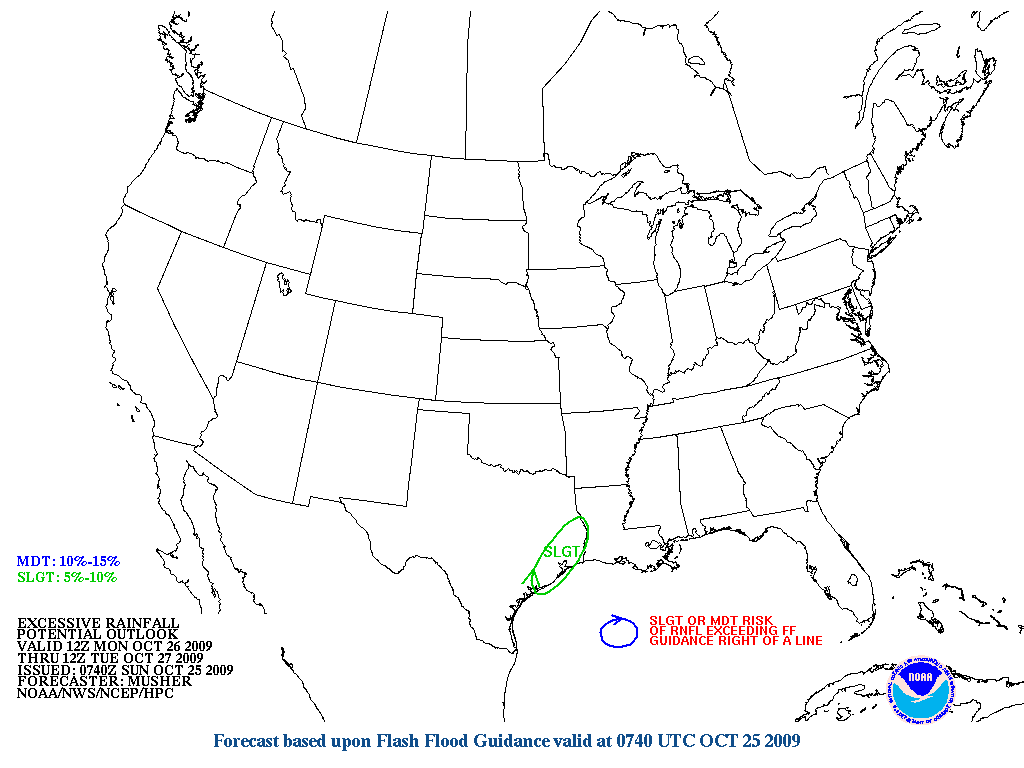
This is around 24 hour away, so a heads up for those of us that mke seen some Heavy Rainfall as of late and no doubt may add to the ongoing flooding issues we are now seeing with a our rivers.
HPC also puts SE TX under a Slight Risk for Excessive Rainfall as well...
This is around 24 hour away, so a heads up for those of us that mke seen some Heavy Rainfall as of late and no doubt may add to the ongoing flooding issues we are now seeing with a our rivers.
0 likes
Carla/Alicia/Jerry(In The Eye)/Michelle/Charley/Ivan/Dennis/Katrina/Rita/Wilma/Ike/Harvey
Member: National Weather Association
Wx Infinity Forums
http://wxinfinity.com/index.php
Facebook.com/WeatherInfinity
Twitter @WeatherInfinity
Member: National Weather Association
Wx Infinity Forums
http://wxinfinity.com/index.php
Facebook.com/WeatherInfinity
Twitter @WeatherInfinity
-
vbhoutex
- Storm2k Executive
- Posts: 29149
- Age: 74
- Joined: Wed Oct 09, 2002 11:31 pm
- Location: Cypress, TX
- Contact:
Re: SE TX/SW LA weather: Cooler weather
You're just full of good news today Steve.  Not what I wanted to see. It seems it is always nothing or everything here when it rains.
0 likes
Skywarn, C.E.R.T.
Please click below to donate to STORM2K to help with the expenses of keeping the site going:
Please click below to donate to STORM2K to help with the expenses of keeping the site going:

Re: SE TX/SW LA weather: Cooler weather
Looks like a storm Monday. Should be interesting. I wouldn't be surprised if there is flooding.
0 likes
-
srainhoutx
- S2K Supporter
- Posts: 6919
- Age: 68
- Joined: Sun Jan 14, 2007 11:34 am
- Location: Haywood County, NC
- Contact:
Re: SE TX/SW LA weather: Cooler weather
Afternoon e-mail from Jeff...May be time to edit the Topic Title again. 
Flash Flood Watch issued for Monday
Texas will experience yet another heavy rainfall event Monday as these warm phase El Nino enhanced weather systems continue to move across the state.
Rapid influx of Gulf moisture today as dewpoints have climbed from the 40's yesterday well into the 60's and now 70's. PWS have greatly increased to near 1.5 inches SW counties. Satellite derived products show W Gulf air mass has 1.8-2.0 inch PWS advecting toward the coastal bend which is nearly 200% above normal for late October standards and raises the red flag for excessive rainfall/flash flooding. Powerful upper level trough digging through the Rockies will arrive into TX later tonight spreading strong lift across the state. 250mb sub-tropical jet will split atop the area leading to impressive jet stream divergence over the area on Monday. Expect to see rapid development of thunderstorms along the frontal boundary as this boundary slams into our juicy air mass. As upper level venting increases early Monday expect to see scattered thunderstorms develop from Matagorda Bay across SE TX in the warm sector. Shear profiles appear favorable for some severe weather...although instability may be lacking...a few damaging wind/hail reports will be possible.
Front moves into the region Monday AM and should clear the coast Monday PM...taking about 12 hours to cross SE TX. While this is usually fast enough to preclude significant rainfall...moisture levels and upper winds becoming parallel to the surface boundary bode well for cell training and excessive short term rainfall rates. While it may only rain for a short period of time...during that time it may rain a significant amount leading to flash flooding.
Widespread 1-3 inches appear likely across the entire region with isolated amounts of 3-5 inches possible. The larger river systems are still in the process of passing upstream flood waves from the heavy rainfalls over the past 2 weeks and this additional rainfall will only aggravate ongoing rises and in some cases flooding (Trinity and lower Guadalupe). Additionally, the potential for 2-3 inch per hour rainfall rates suggest a good potential for urban flash flooding/street flooding.
System rapidly clears the area Monday PM with at least 2 nice days. Next strong storm system sweeps into the region toward the end of the week. GFS on it latest runs paints a troublesome stalling frontal boundary along the coast with strong 250mb sub-tropical flow parallel to the boundary...another big rainfall event? Other models are all over the place with timing of this system and varying rainfall amounts. Will trend toward the wetter and slower solution given current wet pattern in place and increasing influence of the current warm phase ENSO event in the central Pacific...with its resultant downstream signal increasing over TX as we move toward the cool season months.
FLOOD WATCH
NATIONAL WEATHER SERVICE HOUSTON/GALVESTON TX
343 PM CDT SUN OCT 25 2009
TXZ163-164-176>179-195>200-210>214-226-227-235>238-260900-
/O.NEW.KHGX.FF.A.0001.091026T1200Z-091027T0000Z/
/00000.0.ER.000000T0000Z.000000T0000Z.000000T0000Z.OO/
AUSTIN-BRAZORIA-BRAZOS-BURLESON-CHAMBERS-COLORADO-FORT BEND-
GALVESTON-GRIMES-HARRIS-HOUSTON-JACKSON-LIBERTY-MADISON-MATAGORDA-
MONTGOMERY-POLK-SAN JACINTO-TRINITY-WALKER-WALLER-WASHINGTON-
WHARTON-
INCLUDING THE CITIES OF...ALVIN...ANAHUAC...ANGLETON...BAY CITY...
BELLVILLE...BRENHAM...BROOKSHIRE...BRYAN...CALDWELL...CLEVELAND...
COLDSPRING...COLLEGE STATION...COLUMBUS...CONROE...CORRIGAN...
CROCKETT...DAYTON...EAGLE LAKE...EDNA...EL CAMPO...FREEPORT...
FRIENDSWOOD...GALVESTON...GROVETON...HEMPSTEAD...HOUSTON...
HUMBLE...HUNTSVILLE...KATY...LAKE JACKSON...LAKE SOMERVILLE...
LEAGUE CITY...LIBERTY...LIVINGSTON...MADISONVILLE...
MISSOURI CITY...MONT BELVIEU...NAVASOTA...ONALASKA...PALACIOS...
PASADENA...PEARLAND...PIERCE...PRAIRIE VIEW...RICHMOND...
ROSENBERG...SEALY...SHEPHERD...SUGAR LAND...TEXAS CITY...
THE WOODLANDS...TOMBALL...TRINITY...WEIMAR...WHARTON...WILLIS...
WINNIE
343 PM CDT SUN OCT 25 2009
...FLASH FLOOD WATCH IN EFFECT FROM MONDAY MORNING THROUGH MONDAY
EVENING...
THE NATIONAL WEATHER SERVICE IN HOUSTON/GALVESTON HAS ISSUED A
* FLASH FLOOD WATCH FOR A PORTION OF SOUTHEAST TEXAS...INCLUDING
THE FOLLOWING COUNTIES...AUSTIN...BRAZORIA...BRAZOS...
BURLESON...CHAMBERS...COLORADO...FORT BEND...GALVESTON...
GRIMES...HARRIS...HOUSTON...JACKSON...LIBERTY...MADISON...
MATAGORDA...MONTGOMERY...POLK...SAN JACINTO...TRINITY...
WALKER...WALLER...WASHINGTON AND WHARTON.
* FROM MONDAY MORNING THROUGH MONDAY EVENING
* EXCESSIVE RAINFALL IS EXPECTED FROM THUNDERSTORMS EXPECTED TO
DEVELOP ALONG AN ADVANCING COLD FRONT. THIS LINE OF STORMS IS
EXPECTED TO IMPACT SOUTHEAST TEXAS BEGINNING MONDAY MORNING AND
PERSIST THROUGHOUT THE DAY AS THE LINE OF STORMS MOVE ACROSS THE
REGION. SOME THUNDERSTORMS MAY TRAIN OVER THE SAME AREA ADDING
TO THE POTENTIAL FOR HEAVY RAINFALL. MOST AREAS CAN EXPECT 1 TO
3 INCHES OF RAINFALL WITH SOME AREAS OF 5 INCHES. THIS WILL
CAUSE GROUNDS TO BECOME QUICKLY SATURATED AND LEAD TO FLOODING
ESPECIALLY WHERE STORMS TRAIN ACROSS THE SAME AREA.
* RUNOFF FROM ANY HEAVY RAINFALL ACROSS SOUTHEAST TEXAS WILL
IMPACT SWOLLEN RIVERS...STREAMS AND CREEKS. THIS MAY CAUSE
ADDITIONAL RISES IN RIVERS AND MORE RIVER FLOODING.
PRECAUTIONARY/PREPAREDNESS ACTIONS...
A FLASH FLOOD WATCH MEANS THAT CONDITIONS MAY DEVELOP THAT LEAD
TO FLASH FLOODING. FLASH FLOODING IS A VERY DANGEROUS SITUATION.
YOU SHOULD MONITOR LATER FORECASTS AND BE PREPARED TO TAKE ACTION
SHOULD FLASH FLOOD WARNINGS BE ISSUED.
FXUS64 KHGX 252019
AFDHGX
AREA FORECAST DISCUSSION
NATIONAL WEATHER SERVICE HOUSTON/GALVESTON TX
319 PM CDT SUN OCT 25 2009
.DISCUSSION...
GULF MOISTURE CONTINUES TO ADVECT NORTHWARD ACROSS THE COASTAL
BEND AND INTO C TX. MOISTURE WILL SPREAD FROM WEST TO EAST ACROSS
SE TX TONIGHT AHEAD OF AN ADVANCING COLD FRONT. THE COLD FRONT IS
ALREADY PUSHING THROUGH THE TX PANHANDLE WHERE TEMPS HAVE DROPPED
INTO THE 40S. A STRONG UPPER LEVEL TROUGH IS IN THE PROCESS OF
DEEPENING AND SHOULD CLOSE OFF A LOW TONIGHT INTO MON MORNING.
THE FRONT WILL LIKELY OUT RUN THE STRONG QG LIFT ASSOCIATED WITH
THE UPPER LOW BUT DIVERGENCE IN THE JET WITH STILL BE SUPPORTIVE
OF STRONG/SEVERE THUNDERSTORMS WITH A SQUALL LINE DEVELOPING
ALONG THE FRONT IN C TX. SHORT RANGE MODELS ARE IN FAIR AGREEMENT
WITH BRINGING THIS LINE INTO SE TX MON MORNING WITH THE COLD
FRONT TRAILING THE LINE OF STORMS BY ABOUT 3 HOURS. THIS LINE OF
STORMS AND COLD FRONT SHOULD CLEAR SE TX MON NIGHT WITH THE LOW
PUSHING NE INTO THE ARKLATEX AND MID MISS RIVER VALLEY ON TUE.
THIS WILL ALLOW FOR A DRIER/COOLER TUE.
MAIN CONCERNS WITH THIS SYSTEM ARE TWO FOLD. THERE IS A THREAT
FOR SEVERE THUNDERSTORM ACTIVITY BUT THIS LARGELY HINGES ON HOW
MUCH INSTABILITY DEVELOPS. WITH STRONG DIVERGENCE ALOFT WITH JET
DYNAMICS...FORCING MAY BE STRONG ENOUGH TO STILL SUPPORT STRONG
SEVERE/CONVECTION. WIND PROFILES IN THE WARM SECTOR WILL SUPPORT
ORGANIZED STORMS BUT MAINLY LINEAR STRUCTURES ALONG THE FRONT.
THIS MEANS MORE OF A HAIL/DAMAGING WIND THREAT THAN TORNADO.
SHOULD A FEW ISO STORMS FORM IN THE WARM SECTOR AHEAD OF THE
FRONT...MAY SEE A COUPLE STORMS ROTATE. THE OTHER CONCERN IS
HEAVY RAINFALL AND FLOODING. STORMS COULD POSSIBLY BE MOVING
ALONG THE FRONT IN THE MEAN FLOW PARALLEL THE FRONT. SOME CELLS
COULD TRAIN AS THE FRONT SLIDES SOUTHWARD. ALSO...DIVERGENCE
ALOFT WILL BE STRONG AND MOISTURE WITH PW OF 1.7-1.8 INCHES WILL
BE POSSIBLE OVER SE TX. THIS ONLY ADDS TO THE FLOOD POTENTIAL.
DECIDED TO GO WITH A FFA FOR MONDAY GIVEN THIS SET UP.
MIDWEEK SHOULD SEE A QUICK RETURN FLOW EVENT SET UP IN ADVANCE OF
THE NEXT STRONG TROUGH TO DIG INTO THE ROCKIES TUE/WED. THE
GFS/ECMWF SOLUTIONS SEEM TO BE GETTING CLOSER IN AGREEMENT.
FORECAST CURRENTLY CALLS FOR A FAIRLY PROGRESSIVE SYSTEM FOR THE
END OF THE WEEK BUT THIS MAY SIGNIFICANTLY CHANGE SHOULD THE 12Z
GFS BE MORE CORRECT THAN ITS PREVIOUS SOLUTIONS. THIS BASICALLY
CALLS FOR THE FRONT HOLDING UP ALONG THE COAST WITH STRONG JET
FLOW PARALLEL TO THE FRONT. THIS MEANS THUNDERSTORMS/HEAVY RAIN
COULD PERSIST INTO FRI. SHOULD FUTURE MODEL RUNS KEEP THIS
SCENARIO...LIKELY UPDATE THE FORECAST FOR THESE TRENDS. THE
FORECAST FOR NOW KEEPS WITH THE PREVIOUS PACKAGE BUT ADDING SOME
POPS FOR THU NIGHT TO TREND CLOSER TO THE GFS. THIS PART OF THE
WEEK IN THE FORECAST HAS BEEN HIGHLY UNCERTAIN AND SUBJECT TO
SIGNIFICANT CHANGES.
0 likes
Carla/Alicia/Jerry(In The Eye)/Michelle/Charley/Ivan/Dennis/Katrina/Rita/Wilma/Ike/Harvey
Member: National Weather Association
Wx Infinity Forums
http://wxinfinity.com/index.php
Facebook.com/WeatherInfinity
Twitter @WeatherInfinity
Member: National Weather Association
Wx Infinity Forums
http://wxinfinity.com/index.php
Facebook.com/WeatherInfinity
Twitter @WeatherInfinity
Return to “USA & Caribbean Weather”
Who is online
Users browsing this forum: Google [Bot], HockeyTx82, opticsguy and 60 guests