BULLETIN - EAS ACTIVATION REQUESTED
TORNADO WARNING
NATIONAL WEATHER SERVICE NORMAN OK
604 PM CDT MON MAY 10 2010
THE NATIONAL WEATHER SERVICE IN NORMAN HAS ISSUED A
* TORNADO WARNING FOR...
EASTERN KAY COUNTY IN NORTHERN OKLAHOMA...
* UNTIL 645 PM CDT
* AT 605 PM CDT...NATIONAL WEATHER SERVICE RADAR INDICATED A SEVERE
THUNDERSTORM CAPABLE OF PRODUCING A TORNADO 5 MILES WEST OF KAW
CITY...MOVING EAST AT 60 MPH.
* LOCATIONS IN THE WARNING INCLUDE KAW CITY AND KAW LAKE.
PRECAUTIONARY/PREPAREDNESS ACTIONS...
TAKE COVER NOW. LEAVE MOBILE HOMES AND VEHICLES. IF POSSIBLE...MOVE
TO A BASEMENT OR STORM SHELTER. OTHERWISE MOVE TO AN INTERIOR ROOM OR
HALLWAY ON THE LOWEST FLOOR. STAY AWAY FROM WINDOWS AND OUTSIDE
WALLS.
A TORNADO MAY FORM AT ANYTIME. TAKE COVER NOW. ABANDON MOBILE HOMES
AND VEHICLES. IF POSSIBLE..
Next round of severe weather 7th May Onwards?
Moderator: S2k Moderators
Forum rules

The posts in this forum are NOT official forecast and should not be used as such. They are just the opinion of the poster and may or may not be backed by sound meteorological data. They are NOT endorsed by any professional institution or STORM2K.


Re:
CrazyC83 wrote:Injuries reported in Norman.
Sadly thats not all that surprising given the information we are hearing about this system...certainly sounds like we've got some violent tornadoes this eveing.
0 likes
Personal Forecast Disclaimer:
The posts in this forum are NOT official forecast and should not be used as such. They are just the opinion of the poster and may or may not be backed by sound meteorological data. They are NOT endorsed by any professional institution or storm2k.org. For official information, please refer to the NHC and NWS products
The posts in this forum are NOT official forecast and should not be used as such. They are just the opinion of the poster and may or may not be backed by sound meteorological data. They are NOT endorsed by any professional institution or storm2k.org. For official information, please refer to the NHC and NWS products

-
Dave

- Retired Staff

- Posts: 13442
- Age: 75
- Joined: Tue Aug 01, 2006 3:57 pm
- Location: Milan Indiana
- Contact:
BULLETIN - EAS ACTIVATION REQUESTED
TORNADO WARNING
NATIONAL WEATHER SERVICE NORMAN OK
608 PM CDT MON MAY 10 2010
THE NATIONAL WEATHER SERVICE IN NORMAN HAS ISSUED A
* TORNADO WARNING FOR...
SOUTHEASTERN LINCOLN COUNTY IN CENTRAL OKLAHOMA...
NORTHEASTERN POTTAWATOMIE COUNTY IN CENTRAL OKLAHOMA...
NORTHERN SEMINOLE COUNTY IN EAST CENTRAL OKLAHOMA...
NORTHERN HUGHES COUNTY IN SOUTHEAST OKLAHOMA...
* UNTIL 715 PM CDT
* AT 608 PM CDT...NATIONAL WEATHER SERVICE RADAR INDICATED A SEVERE
THUNDERSTORM CAPABLE OF PRODUCING A TORNADO 3 MILES WEST OF
EARLSBORO...MOVING EAST AT 60 MPH.
* LOCATIONS IN THE WARNING INCLUDE AYDELOTTE...BOWLEGS...
CENTERVIEW...CROMWELL...DUSTIN...EARLSBORO...HARJO...JOHNSON...
LIMA...LITTLE...MEEKER...PRAGUE...SEMINOLE...SHAWNEE...TECUMSEH...
WETUMKA...WEWOKA AND YEAGER.
THIS INCLUDES INTERSTATE 40 BETWEEN MILE MARKERS 183 AND 213.
PRECAUTIONARY/PREPAREDNESS ACTIONS...
IN ADDITION TO A TORNADO THREAT... THIS STORM LIKELY CONTAINS
DAMAGING HAIL TO THE SIZE OF BASEBALLS OR LARGER.
0 likes
-
Texas Snowman

- Storm2k Moderator

- Posts: 6197
- Joined: Fri Jan 25, 2008 11:29 am
- Location: Denison, Texas
TWC showing air-based footage that appears to show slabs wiped clean. Don't know where it is at.
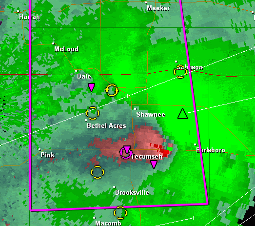
Jim Cantore is saying a large wedge tornado on ground, very impressive radar signature near Shawnee...
Jim Cantore is saying a large wedge tornado on ground, very impressive radar signature near Shawnee...
0 likes
The above post and any post by Texas Snowman is NOT an official forecast and should not be used as such. It is just the opinion of the poster and may or may not be backed by sound meteorological data. It is NOT endorsed by any professional institution including storm2k.org. For official information, please refer to NWS products.


-
Texas Snowman
- Storm2k Moderator
- Posts: 6197
- Joined: Fri Jan 25, 2008 11:29 am
- Location: Denison, Texas
News 9 - storm near Tecumseh has strongest TVS seen so far this afternoon.
Spotters reporting tornado on the ground near Healdton. Ardmore look out...
Spotters reporting tornado on the ground near Healdton. Ardmore look out...
0 likes
The above post and any post by Texas Snowman is NOT an official forecast and should not be used as such. It is just the opinion of the poster and may or may not be backed by sound meteorological data. It is NOT endorsed by any professional institution including storm2k.org. For official information, please refer to NWS products.
-
Texas Snowman
- Storm2k Moderator
- Posts: 6197
- Joined: Fri Jan 25, 2008 11:29 am
- Location: Denison, Texas
News 9 showing cars overturned on I-40 at I-40/Choctaw...
0 likes
The above post and any post by Texas Snowman is NOT an official forecast and should not be used as such. It is just the opinion of the poster and may or may not be backed by sound meteorological data. It is NOT endorsed by any professional institution including storm2k.org. For official information, please refer to NWS products.
-
Dave
- Retired Staff
- Posts: 13442
- Age: 75
- Joined: Tue Aug 01, 2006 3:57 pm
- Location: Milan Indiana
- Contact:
MURRAY OK-JOHNSTON OK-CARTER OK-
613 PM CDT MON MAY 10 2010
...A TORNADO WARNING REMAINS IN EFFECT UNTIL 645 PM CDT FOR
NORTHEASTERN CARTER...NORTHWESTERN JOHNSTON AND MURRAY COUNTIES...
AT 613 PM CDT...RADAR AND STORM SPOTTERS OBSERVED A TORNADO 19 MILES
WEST OF SPRINGER...MOVING EAST AT 50 MPH. ANOTHER STORM CAPABLE OF
PRODUCING A TORNADO WAS LOCATED NEAR POOLEVILLE...MOVING EAST AT 50
MPH...IN THE DIRECTION OF TURNER FALLS.
* LOCATIONS IN THE WARNING INCLUDE DAVIS...DOUGHERTY...GENE AUTRY...
HENNEPIN...HICKORY...LAKE OF THE ARBUCKLES...SCULLIN...SPRINGER...
SULPHUR AND TURNER FALLS.
THIS INCLUDES INTERSTATE 35 BETWEEN MILE MARKERS 35 AND 55.
0 likes
-
apocalypt-flyer
- Category 1

- Posts: 468
- Joined: Sat Aug 27, 2005 11:51 am
Re:
Bunkertor wrote:
That really is massive. If it didn't look like a massive wall rolling over Oklahome 90 minutes ago, it SURE does now.
And it's only just 6.15pm. Dread to think what the rest of the evening has in store.
0 likes


-
Dave
- Retired Staff
- Posts: 13442
- Age: 75
- Joined: Tue Aug 01, 2006 3:57 pm
- Location: Milan Indiana
- Contact:
BULLETIN - EAS ACTIVATION REQUESTED
TORNADO WARNING
NATIONAL WEATHER SERVICE NORMAN OK
611 PM CDT MON MAY 10 2010
THE NATIONAL WEATHER SERVICE IN NORMAN HAS ISSUED A
* TORNADO WARNING FOR...
NORTHEASTERN NOBLE COUNTY IN NORTHERN OKLAHOMA...
* UNTIL 700 PM CDT
* AT 611 PM CDT...NATIONAL WEATHER SERVICE RADAR INDICATED A SEVERE
THUNDERSTORM CAPABLE OF PRODUCING A TORNADO 5 MILES SOUTHEAST OF
MARLAND...MOVING NORTHEAST AT 65 MPH.
* LOCATIONS IN THE WARNING INCLUDE MARLAND AND SOONER LAKE.
0 likes

Short Term Forecast
SHORT TERM FORECAST
NATIONAL WEATHER SERVICE NORMAN OK
616 PM CDT MON MAY 10 2010
OKZ004>048-050>052-TXZ083>090-110015-
ALFALFA-ARCHER-ATOKA-BAYLOR-BECKHAM-BLAINE-BRYAN-CADDO-CANADIAN-
CARTER-CLAY-CLEVELAND-COAL-COMANCHE-COTTON-CUSTER-DEWEY-ELLIS-FOARD-
GARFIELD-GARVIN-GRADY-GRANT-GREER-HARDEMAN-HARMON-HARPER-HUGHES-
JACKSON-JEFFERSON-JOHNSTON-KAY-KINGFISHER-KIOWA-KNOX-LINCOLN-LOGAN-
LOVE-MAJOR-MARSHALL-MCCLAIN-MURRAY-NOBLE-OKLAHOMA-PAYNE-PONTOTOC-
POTTAWATOMIE-ROGER MILLS-SEMINOLE-STEPHENS-TILLMAN-WASHITA-WICHITA-
WILBARGER-
616 PM CDT MON MAY 10 2010
.REGIONAL WEATHER DISCUSSION...
...EXTREMELY DANGEROUS TORNADO OUTBREAK UNFOLDING ACROSS OKLAHOMA...
THE ENVIRONMENT OVER CENTRAL AND SOUTH CENTRAL OKLAHOMA REMAINS
EXTREMELY FAVORABLE FOR SIGNIFICANT TORNADIC SUPERCELLS...AND AS
STORMS CONTINUE TO MOVE ACROSS THE AREA THIS EVENING THEY COULD
PRODUCE STRONG TORNADOES AND GIANT HAIL.
SCATTERED SUPERCELL THUNDERSTORMS WERE MOVING ACROSS PARTS OF
CENTRAL OKLAHOMA. THESE THUNDERSTORMS WERE GENERALLY MOVING RAPIDLY
TO THE NORTHEAST OVER 50 MPH.
HOWEVER...REDEVELOPMENT WAS OCCURRING BEHIND THE INITIAL ROUND OF
THUNDERSTORMS...AND SOME OF THESE STORMS WERE ALSO BECOMING SEVERE.
PAY ATTENTION TO THE LATEST INFORMATION AND DO NOT LET YOUR GUARD
DOWN IF YOU ARE EAST OF A LINE FROM NEWKIRK...TO OKLAHOMA CITY...TO
WALTERS.
THIS IS AN EXTREMELY DANGEROUS SITUATION. PERSONS IN CENTRAL
OKLAHOMA SHOULD BE AT A HIGH STATE OF ALERT...AND BE PREPARED TO ACT
CALMLY AND QUICKLY IF A WARNING IS ISSUED FOR THEIR LOCATION. STORM
MOTIONS WILL BE VERY FAST...SO WAITING FOR VISUAL CLUES TO SEEK
SHELTER MAY CAUSE YOU TO REACT TOO SLOWLY.
0 likes
The following post is NOT an official forecast and should not be used as such. It is just the opinion of the poster and may or may not be backed by sound meteorological data. It is NOT endorsed by any professional institution including storm2k.org For Official Information please refer to the NHC and NWS products.
-
Texas Snowman
- Storm2k Moderator
- Posts: 6197
- Joined: Fri Jan 25, 2008 11:29 am
- Location: Denison, Texas
Apparently two tornadoes on the ground in Carter County in S/C Oklahoma.
Ardmore sounding storm sirens. Wall cloud near Lone Grove which was hit by a killer EF-4 in February 2009...
Ardmore sounding storm sirens. Wall cloud near Lone Grove which was hit by a killer EF-4 in February 2009...
0 likes
The above post and any post by Texas Snowman is NOT an official forecast and should not be used as such. It is just the opinion of the poster and may or may not be backed by sound meteorological data. It is NOT endorsed by any professional institution including storm2k.org. For official information, please refer to NWS products.

Re: Next round of severe weather 7th May Onwards?
Tornado on the Ground heading for Lake Murray State Park.
0 likes
-
Texas Snowman
- Storm2k Moderator
- Posts: 6197
- Joined: Fri Jan 25, 2008 11:29 am
- Location: Denison, Texas
Re:
CrazyC83 wrote:Slabs wiped clean? If those were solid structures, that is at least EF4, if not EF5 damage...
That's what it looked like from the air shot. Could have been a pier-and-beam construction...
Now News 9 saying a "lot of injuries"...don't know if that's confirmed or speculation but it would not be surprising at all.
0 likes
The above post and any post by Texas Snowman is NOT an official forecast and should not be used as such. It is just the opinion of the poster and may or may not be backed by sound meteorological data. It is NOT endorsed by any professional institution including storm2k.org. For official information, please refer to NWS products.
Return to “USA & Caribbean Weather”
Who is online
Users browsing this forum: AnnularCane, SnowyOwl31, South Texas Storms, wxman22 and 181 guests