Memorial Day Weekend Outbreak 2008
Moderator: S2k Moderators
Forum rules

The posts in this forum are NOT official forecast and should not be used as such. They are just the opinion of the poster and may or may not be backed by sound meteorological data. They are NOT endorsed by any professional institution or STORM2K.

-
brunota2003

- S2K Supporter

- Posts: 9476
- Age: 35
- Joined: Sat Jul 30, 2005 9:56 pm
- Location: Stanton, KY...formerly Havelock, NC
- Contact:
-
Texas Snowman

- Storm2k Moderator

- Posts: 6197
- Joined: Fri Jan 25, 2008 11:29 am
- Location: Denison, Texas

Re:
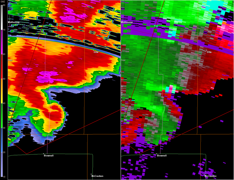
Texas Snowman wrote:How big is Ellis?
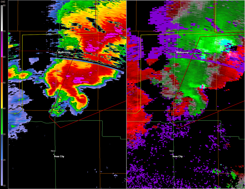
At 828 PM CDT... National Weather Service meteorologists and storm
spotters were tracking a large and extremely dangerous tornado 1
miles southwest of Ellis... moving northeast at 30 mph.
Last edited by RL3AO on Sun May 25, 2008 11:00 am, edited 2 times in total.
0 likes
-
CrazyC83
- Professional-Met

- Posts: 34315
- Joined: Tue Mar 07, 2006 11:57 pm
- Location: Deep South, for the first time!
Re: Re:
Bunkertor wrote:RL3AO wrote:Same image, zoomed out.
So, Greensburg is totally done, now.
Now waiting for reports. Downtown looks to have been spared, but I am worried about the areas just south of town (if there are any FEMA parks there).
0 likes
-
MiamiensisWx
...A TORNADO WARNING REMAINS IN EFFECT UNTIL 900 PM CDT FOR NORTH
CENTRAL NESS...ELLIS AND EASTERN TREGO COUNTIES...
AT 835 PM CDT...NATIONAL WEATHER SERVICE METEOROLOGISTS AND STORM
SPOTTERS WERE TRACKING A LARGE AND EXTREMELY DANGEROUS TORNADO 4
MILES NORTHEAST OF ELLIS...MOVING NORTHEAST AT 34 MPH.
ANOTHER TORNADIC STORM WAS LOCATED NEAR NEAR CEDAR BLUFF...
MOVING NORTHEAST AT 30 MPH.
* LOCATIONS IMPACTED INCLUDE...
RURAL RESIDENCES OF WESTERN AND NORTHERN ELLIS AND NORTHERN
NESS COUNTIES...
ELLIS...
YOCEMENTO...
AT 832 PM...A TRUCK WAS FLIPPED OVER AT MILE MARKER 140 ON
INTERSTATE 70.
THIS STORM HAS A HISTORY OF PRODUCING TORNADOES CAUSING SIGNIFICANT
DAMAGE IN ELLIS. RESIDENTS OF NORTHERN AND WESTERN ELLIS COUNTY
SHOULD TAKE SHELTER IMMEDIATELY. THIS IS A LIFE THREATENING
SITUATION.
Ellis, KS has been hit by a "large tornado"...
0 likes
-
6SpeedTA95
- Category 5

- Posts: 1206
- Joined: Wed Oct 19, 2005 3:25 pm
- Location: Oklahoma
- Contact:
Re:
CrazyC83 wrote:First tornado (the northern cell) - MISSED Greensburg, damage 3 miles to the west
Good, although that storm looks like its getting its poop together again.
0 likes
-
Texas Snowman
- Storm2k Moderator
- Posts: 6197
- Joined: Fri Jan 25, 2008 11:29 am
- Location: Denison, Texas
-
6SpeedTA95
- Category 5
- Posts: 1206
- Joined: Wed Oct 19, 2005 3:25 pm
- Location: Oklahoma
- Contact:
-
HarlequinBoy

- Category 5
- Posts: 1400
- Age: 35
- Joined: Wed Nov 29, 2006 1:57 am
- Location: Memphis
-
6SpeedTA95
- Category 5
- Posts: 1206
- Joined: Wed Oct 19, 2005 3:25 pm
- Location: Oklahoma
- Contact:

Return to “USA & Caribbean Weather”
Who is online
Users browsing this forum: A1A, AnnularCane and 128 guests