Kristi
Major tornado outbreak Sunday...the aftermath..
Moderator: S2k Moderators
Forum rules

The posts in this forum are NOT official forecast and should not be used as such. They are just the opinion of the poster and may or may not be backed by sound meteorological data. They are NOT endorsed by any professional institution or STORM2K.
-
simplykristi
- S2K Supporter

- Posts: 1220
- Joined: Sat May 10, 2003 1:59 pm
- Location: Near KCMO
- Contact:
-
simplykristi
- S2K Supporter
- Posts: 1220
- Joined: Sat May 10, 2003 1:59 pm
- Location: Near KCMO
- Contact:

-
wx247

- S2K Supporter
- Posts: 14279
- Age: 42
- Joined: Wed Feb 05, 2003 10:35 pm
- Location: Monett, Missouri
- Contact:
Cells should travel just south of the Nashville metro if my tracker is correct.
0 likes
Personal Forecast Disclaimer:
The posts in this forum are NOT official forecast and should not be used as such. They are just the opinion of the poster and may or may not be backed by sound meteorological data. They are NOT endorsed by any professional institution or storm2k.org. For official information, please refer to the NHC and NWS products.
The posts in this forum are NOT official forecast and should not be used as such. They are just the opinion of the poster and may or may not be backed by sound meteorological data. They are NOT endorsed by any professional institution or storm2k.org. For official information, please refer to the NHC and NWS products.


-
conestogo_flood
- Category 5

- Posts: 1268
- Joined: Wed Sep 28, 2005 5:49 pm
CIVIL EMERGENCY MESSAGE
RELAYED BY NATIONAL WEATHER SERVICE MEMPHIS TN
900 PM CDT SUN APR 2 2006
THE EMERGENCY MANAGEMENT OFFICE IN PEMISCOT COUNTY MISSOURI HAS
REQUESTED THAT NO PERSONS OTHER THAN LOCAL RESIDENTS ENTER THE CITY
OF CARUTHERSVILLE OVERNIGHT TONIGHT...DUE TO DAMAGE CAUSED BY A
TORNADO EARLIER THIS EVENING.
RELAYED BY NATIONAL WEATHER SERVICE MEMPHIS TN
900 PM CDT SUN APR 2 2006
THE EMERGENCY MANAGEMENT OFFICE IN PEMISCOT COUNTY MISSOURI HAS
REQUESTED THAT NO PERSONS OTHER THAN LOCAL RESIDENTS ENTER THE CITY
OF CARUTHERSVILLE OVERNIGHT TONIGHT...DUE TO DAMAGE CAUSED BY A
TORNADO EARLIER THIS EVENING.
0 likes
-
conestogo_flood
- Category 5
- Posts: 1268
- Joined: Wed Sep 28, 2005 5:49 pm
-
cheezyWXguy

- Category 5
- Posts: 6282
- Joined: Mon Feb 13, 2006 12:29 am
- Location: Dallas, TX
-
Gorky

- Category 1

- Posts: 334
- Joined: Tue Nov 02, 2004 7:23 am
- Location: Scarborough, North Yorkshire, UK
The tornado warned cell NE of memphis is being absorbed into the larger cell NW by the looks of it. That cell itself was already looking very good, but I have a feeling this cell is going to be another biggie... IT should have absolutely no problem maintaining it's intensity, even this late on.
It's also just started to show a TVS and a nice hook is forming. It's heading towards Jackson, Tennessee
It's also just started to show a TVS and a nice hook is forming. It's heading towards Jackson, Tennessee
0 likes
-
Extremeweatherguy

- Category 5
- Posts: 11095
- Joined: Mon Oct 10, 2005 8:13 pm
- Location: Florida
-
Matt-hurricanewatcher
-
Matt-hurricanewatcher
-
Extremeweatherguy
- Category 5
- Posts: 11095
- Joined: Mon Oct 10, 2005 8:13 pm
- Location: Florida
No. 3/12 featured 140 tornado reports and 669 total severe reports. If the severe weather continues, however, then there may be a chance. Here is a comparison of tonight's outbreak (so far) and 3/12:cheezywxman wrote:what a night! has this beaten 3/12 yet?
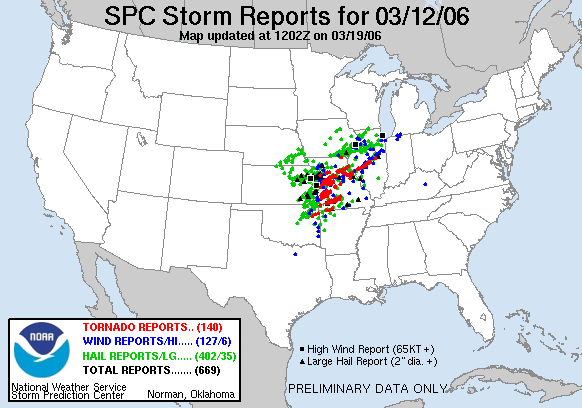
^^3/12^^

^^Today^^
**We are beating 3/12 in overall area though, and we are also beating 3/12 in the total number of wind reports**
0 likes
-
conestogo_flood
- Category 5
- Posts: 1268
- Joined: Wed Sep 28, 2005 5:49 pm
-
therock1811

- Category 5
- Posts: 5163
- Age: 40
- Joined: Thu May 15, 2003 2:15 pm
- Location: Kentucky
- Contact:
-
therock1811
- Category 5
- Posts: 5163
- Age: 40
- Joined: Thu May 15, 2003 2:15 pm
- Location: Kentucky
- Contact:
Return to “USA & Caribbean Weather”
Who is online
Users browsing this forum: Brent and 89 guests