Texas Spring-2015

U.S. & Caribbean Weather Discussions and Severe Weather Events

Moderator: S2k Moderators

Forum rules

The posts in this forum are NOT official forecast and should not be used as such. They are just the opinion of the poster and may or may not be backed by sound meteorological data. They are NOT endorsed by any professional institution or STORM2K.

Help Support Storm2K
Message
Author
TarrantWx
Category 1
Category 1
Posts: 287
Age: 39
Joined: Thu Jan 30, 2014 10:38 am
Location: Keller, TX

Re:

#501 Postby TarrantWx » Wed Apr 22, 2015 1:48 pm

Texas Snowman wrote:Yup, sun back out in Denison. That should help increase instability this afternoon.

Also, saw a forecast radar (not sure which one) on Twitter, it has a very healthy supercell approaching the Metroplex later today about sundown. Guess we'll see.


Think you're talking about this one?

Image
0 likes   

User avatar
Texas Snowman
Storm2k Moderator
Storm2k Moderator
Posts: 6179
Joined: Fri Jan 25, 2008 11:29 am
Location: Denison, Texas

#502 Postby Texas Snowman » Wed Apr 22, 2015 1:55 pm

:uarrow: That's the one.
0 likes   
The above post and any post by Texas Snowman is NOT an official forecast and should not be used as such. It is just the opinion of the poster and may or may not be backed by sound meteorological data. It is NOT endorsed by any professional institution including storm2k.org. For official information, please refer to NWS products.

JayDT
Category 1
Category 1
Posts: 354
Joined: Tue Dec 16, 2014 12:55 pm
Location: Dallas, Texas

#503 Postby JayDT » Wed Apr 22, 2015 1:57 pm

Completely cloudy down here in Duncanville. Feels pretty "cool" outside, but kind of eerie at the same time. Idk, maybe its just me. lol
0 likes   

User avatar
TheProfessor
Professional-Met
Professional-Met
Posts: 3506
Age: 28
Joined: Tue Dec 03, 2013 10:56 am
Location: Wichita, Kansas

#504 Postby TheProfessor » Wed Apr 22, 2015 1:57 pm

Man the HRRR sure does cut it close, looks like the super cells converge right on Denton County, if it's off by even 30 miles it could be devastating. http://mp1.met.psu.edu/~fxg1/HRRRSC_CUR/rloop.html
0 likes   
An alumnus of The Ohio State University.

Your local National Weather Service office is your best source for weather information.

Brent
S2K Supporter
S2K Supporter
Posts: 38088
Age: 36
Joined: Sun May 16, 2004 10:30 pm
Location: Tulsa Oklahoma
Contact:

Re: Texas Spring-2015

#505 Postby Brent » Wed Apr 22, 2015 2:17 pm

Image

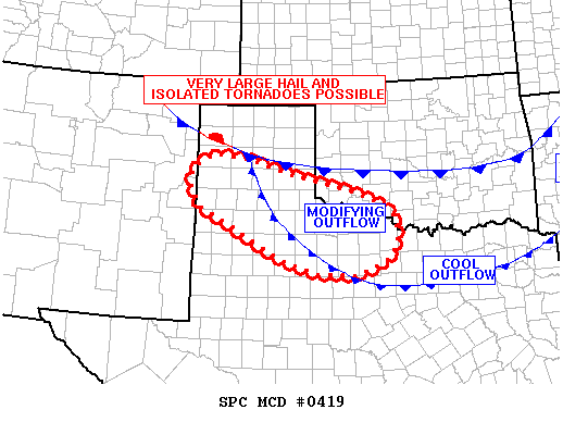
MESOSCALE DISCUSSION 0419
NWS STORM PREDICTION CENTER NORMAN OK
0207 PM CDT WED APR 22 2015

AREAS AFFECTED...TX PANHANDLE INTO NWRN TX

CONCERNING...SEVERE POTENTIAL...WATCH LIKELY

VALID 221907Z - 222130Z

PROBABILITY OF WATCH ISSUANCE...95 PERCENT

SUMMARY...SUPERCELLS ARE EXPECTED TO FORM QUICKLY THIS AFTERNOON
ACROSS THE TX PANHANDLE AND EVOLVE SEWD ACROSS NWRN TX AND PERHAPS
EXTREME SWRN OK. VERY LARGE HAIL IS LIKELY ALONG WITH DAMAGING WINDS
AND A TORNADO OR TWO.

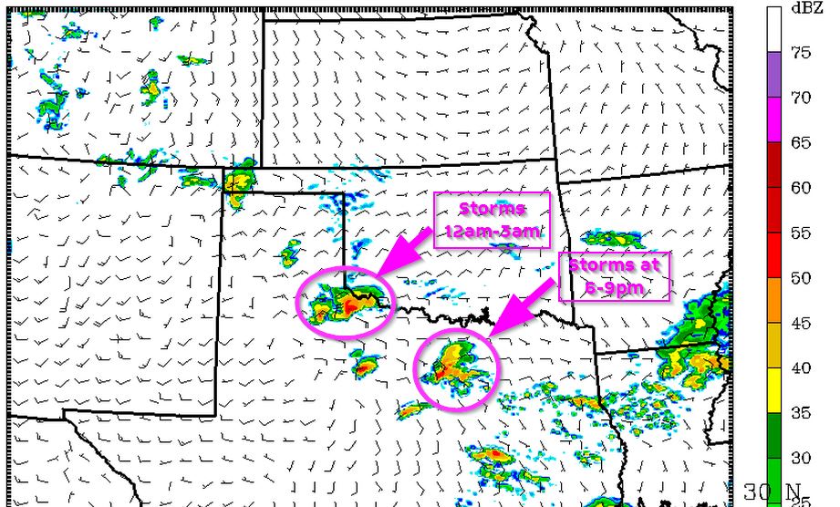
DISCUSSION...VISIBLE IMAGERY SHOWS CU FIELDS EXPANDING ACROSS FAR
ERN NM N OF CLOVIS AND INTO THE TX PANHANDLE S AND W OF A STALLED
FRONT AND OUTFLOW BOUNDARY...RESPECTIVELY. HERE...INSTABILITY IS
INCREASING DUE TO COLD TEMPERATURES ALOFT...WITH STRONG HEATING AND
LOW-LEVEL MOISTURE ADVECTION OUT OF THE SE WITH DEWPOINTS RISING
INTO THE UPPER 50S TOWARD THE CAPROCK.

BY 20-21Z...SUPERCELLS ARE EXPECTED TO TAKE SHAPE AND WILL DEVELOP
SE...POSSIBLY LASTING SEVERAL HOURS WITH SWATHS OF VERY LARGE
HAIL...DAMAGING WIND AND A FEW BRIEF TORNADOES. LOW-LEVEL SHEAR WILL
LIKELY REMAIN STRONGEST NEAR OLD OUTFLOW BOUNDARY...FROM AMA TO SPS.
0 likes   
#neversummer

newtotex
Tropical Storm
Tropical Storm
Posts: 231
Age: 37
Joined: Wed Jan 05, 2011 5:19 pm
Location: Denton, Tx

Re: Re:

#506 Postby newtotex » Wed Apr 22, 2015 2:25 pm

Brent wrote:
dhweather wrote:Well, we can start with low dew points - it was 53 in Heath last night. It has rebounded to 65, which is more favorable, but I just do not think the atmosphere is ripe, per se. Too bad we didn't get the extra sounding in, that would be helpful in seeing how things are. The cloud cover is still here in Heath, temp 72, down 1.5 degrees in the last hour. That isn't creating any instability. I just don't think it feels right for tornado weather, maybe not even widespread supercells.


Brent, you are an Alabama boy, so as a Mississippi boy, you know what I mean when I say "tornado weather", and today ain't it.


The sun is trying to peek out here and I see blue sky but when I walked outside you could feel a cool tint to the air... definitely not tornado weather. I know exactly what you mean... on most of the bad spring outbreak days in Alabama you could just walk outside and feel a sense of doom. That's not to say there can't be a couple of tornadoes here and there, but I just don't feel it's an outbreak day(and tbh the tornado probability is 5% which is hardly high)

Now granted in Alabama we used to get low cape/high shear events in the middle of the winter with weather like this, but this isn't winter.


Yea both you guys, I grew up in Alabama as well, Tuscaloosa, and moved to Texas for college. I definitely know what you mean by "Tornado Weather" in Bama. I don't recall ever getting that "scary tornado weather" feeling while being in Texas that I would get in Bama, that cap always seems to be an inhibiting factor here. Partly cloudy skies with sun coming out, high dp, strong winds out of the S/SE, you could just feel it in the air, that's the conditions I always associated with tornado weather back home.
0 likes   

Brent
S2K Supporter
S2K Supporter
Posts: 38088
Age: 36
Joined: Sun May 16, 2004 10:30 pm
Location: Tulsa Oklahoma
Contact:

Re: Re:

#507 Postby Brent » Wed Apr 22, 2015 2:30 pm

newtotex wrote:
Brent wrote:
dhweather wrote:Well, we can start with low dew points - it was 53 in Heath last night. It has rebounded to 65, which is more favorable, but I just do not think the atmosphere is ripe, per se. Too bad we didn't get the extra sounding in, that would be helpful in seeing how things are. The cloud cover is still here in Heath, temp 72, down 1.5 degrees in the last hour. That isn't creating any instability. I just don't think it feels right for tornado weather, maybe not even widespread supercells.


Brent, you are an Alabama boy, so as a Mississippi boy, you know what I mean when I say "tornado weather", and today ain't it.


The sun is trying to peek out here and I see blue sky but when I walked outside you could feel a cool tint to the air... definitely not tornado weather. I know exactly what you mean... on most of the bad spring outbreak days in Alabama you could just walk outside and feel a sense of doom. That's not to say there can't be a couple of tornadoes here and there, but I just don't feel it's an outbreak day(and tbh the tornado probability is 5% which is hardly high)

Now granted in Alabama we used to get low cape/high shear events in the middle of the winter with weather like this, but this isn't winter.


Yea both you guys, I grew up in Alabama as well, Tuscaloosa, and moved to Texas for college. I definitely know what you mean by "Tornado Weather" in Bama. I don't recall ever getting that "scary tornado weather" feeling while being in Texas that I would get in Bama, that cap always seems to be an inhibiting factor here. Partly cloudy skies with sun coming out, high dp, strong winds out of the S/SE, you could just feel it in the air, that's the conditions I always associated with tornado weather back home.


Dang, another Alabama person. :P

When did you leave Tuscaloosa?
0 likes   
#neversummer

User avatar
Texas Snowman
Storm2k Moderator
Storm2k Moderator
Posts: 6179
Joined: Fri Jan 25, 2008 11:29 am
Location: Denison, Texas

Re: Re:

#508 Postby Texas Snowman » Wed Apr 22, 2015 2:42 pm

newtotex wrote:
Brent wrote:
dhweather wrote:Well, we can start with low dew points - it was 53 in Heath last night. It has rebounded to 65, which is more favorable, but I just do not think the atmosphere is ripe, per se. Too bad we didn't get the extra sounding in, that would be helpful in seeing how things are. The cloud cover is still here in Heath, temp 72, down 1.5 degrees in the last hour. That isn't creating any instability. I just don't think it feels right for tornado weather, maybe not even widespread supercells.


Brent, you are an Alabama boy, so as a Mississippi boy, you know what I mean when I say "tornado weather", and today ain't it.


The sun is trying to peek out here and I see blue sky but when I walked outside you could feel a cool tint to the air... definitely not tornado weather. I know exactly what you mean... on most of the bad spring outbreak days in Alabama you could just walk outside and feel a sense of doom. That's not to say there can't be a couple of tornadoes here and there, but I just don't feel it's an outbreak day(and tbh the tornado probability is 5% which is hardly high)

Now granted in Alabama we used to get low cape/high shear events in the middle of the winter with weather like this, but this isn't winter.


Yea both you guys, I grew up in Alabama as well, Tuscaloosa, and moved to Texas for college. I definitely know what you mean by "Tornado Weather" in Bama. I don't recall ever getting that "scary tornado weather" feeling while being in Texas that I would get in Bama, that cap always seems to be an inhibiting factor here. Partly cloudy skies with sun coming out, high dp, strong winds out of the S/SE, you could just feel it in the air, that's the conditions I always associated with tornado weather back home.


We've certainly had such "tornado weather" here in the past, especially in the month of May, when tornadoes peak here.

Keep in mind that recent years - say from 2000 until now - are not necessarily what most springs are historically like here in Texas. We've been in an on-again, off-again decade long drought that has limited our severe weather events, particularly here in North Texas. Most of the really violent weather has been confined to central Oklahoma during that span and has stayed outside of Texas' borders.

While the number of overall Texas twisters has been up there at times during the last 15 years, we have not had one of the mega-tornadoes that has caused tremendous property damage and deaths (like the 114 killed in Waco during the May 11, 1953 storm).

But as dhweather alluded to earlier, we're living on borrowed time in the DFW area and North Texas, an area that has grown tremendously during the last 20 years. Run the El Reno tornado or either one of the Moore tornadoes through the heart of the Metroplex and I shudder to think what the death toll might be.

Here's a couple of interesting lists concerning Texas twisters:

http://texasalmanac.com/sites/default/f ... does14.pdf

http://www.tornadoproject.com/alltorns/worstts.htm

http://www.srh.noaa.gov/ama/?n=top10_tornadoes

https://tshaonline.org/handbook/online/articles/ydt01
0 likes   
The above post and any post by Texas Snowman is NOT an official forecast and should not be used as such. It is just the opinion of the poster and may or may not be backed by sound meteorological data. It is NOT endorsed by any professional institution including storm2k.org. For official information, please refer to NWS products.

User avatar
Texas Snowman
Storm2k Moderator
Storm2k Moderator
Posts: 6179
Joined: Fri Jan 25, 2008 11:29 am
Location: Denison, Texas

#509 Postby Texas Snowman » Wed Apr 22, 2015 2:45 pm

Don't look now, but some big storms are starting to initiate from Abilene to the south towards Interstate 10.
0 likes   
The above post and any post by Texas Snowman is NOT an official forecast and should not be used as such. It is just the opinion of the poster and may or may not be backed by sound meteorological data. It is NOT endorsed by any professional institution including storm2k.org. For official information, please refer to NWS products.

User avatar
Ntxw
Storm2k Moderator
Storm2k Moderator
Posts: 22784
Joined: Wed Oct 21, 2009 6:34 pm
Location: DFW, Texas

Re: Re:

#510 Postby Ntxw » Wed Apr 22, 2015 2:46 pm

Texas Snowman wrote:We've certainly had such "tornado weather" here in the past, especially in the month of May, when tornadoes peak here.

Keep in mind that recent years - say from 2000 until now - are not necessarily what most springs are historically like here in Texas. We've been in an on-again, off-again decade long drought that has limited our severe weather events, particularly here in North Texas. Most of the really violent weather has been confined to central Oklahoma during that span and has stayed outside of Texas' borders.

While the number of overall Texas twisters has been up there at times during the last 15 years, we have not had one of the mega-tornadoes that has caused tremendous property damage and deaths (like the 114 killed in Waco during the May 11, 1953 storm).

But as dhweather alluded to earlier, we're living on borrowed time in the DFW area and North Texas, an area that has grown tremendously during the last 20 years. Run the El Reno tornado or either one of the Moore tornadoes through the heart of the Metroplex and I shudder to think what the death toll might be.1


It's a love/hate relationship with the cap. Without the cap we won't bottle up enough energy, and you get junk convection that stabilizes the atmosphere. With the cap sometimes storms don't initialize or weaken. It is days when the cap is broken in the afternoon after all the energy is built up that's when things go violent in Texas very quickly. It's like a boiling pot of water. Keep the lid on it just gains pressures, take off the lid and everything goes whoosh. But turn it off before the lid goes and just a simmer.
0 likes   
The above post and any post by Ntxw is NOT an official forecast and should not be used as such. It is just the opinion of the poster and may or may not be backed by sound meteorological data. It is NOT endorsed by any professional institution including Storm2k. For official information, please refer to NWS products.

  Help support Storm2K!
Help Support Storm2K

MSUDawg
Tropical Storm
Tropical Storm
Posts: 103
Joined: Fri Jan 07, 2011 11:07 pm
Location: Carrollton

Re: Re:

#511 Postby MSUDawg » Wed Apr 22, 2015 2:49 pm

Brent wrote:Dang, another Alabama person. :P

When did you leave Tuscaloosa?


I'll NEVER claim Bama... as I grew up in Mississippi but I did live in Northport for 4-5 years and parent are still there.
Still follow James Spann online. He is one of the people who made me start to follow weather. I know what yall mean and remember several tornadoes hitting including the F4 in Dec 2000.

Now I'm here in DFW.
0 likes   

Brent
S2K Supporter
S2K Supporter
Posts: 38088
Age: 36
Joined: Sun May 16, 2004 10:30 pm
Location: Tulsa Oklahoma
Contact:

Re: Re:

#512 Postby Brent » Wed Apr 22, 2015 2:50 pm

MSUDawg wrote:
Brent wrote:Dang, another Alabama person. :P

When did you leave Tuscaloosa?


I'll NEVER claim Bama... as I grew up in Mississippi but I did live in Northport for 4-5 years and parent are still there.
Still follow James Spann online. He is one of the people who made me start to follow weather. I know what yall mean and remember several tornadoes hitting including the F4 in Dec 2000.

Now I'm here in DFW.


I lived in small towns in East Alabama(the other side of the state from Tuscaloosa) all my life until about 7 months ago... came out here for an opportunity and haven't really looked back.

My weather interest started in the mid 90s and in the early 2000s I actually met James Spann in person and I've been a follower ever since, On 4/27/11 I sat there watching Spann for 10 hours straight and the day haunted me for awhile tbh.
Last edited by Brent on Wed Apr 22, 2015 2:54 pm, edited 2 times in total.
0 likes   
#neversummer

User avatar
Texas Snowman
Storm2k Moderator
Storm2k Moderator
Posts: 6179
Joined: Fri Jan 25, 2008 11:29 am
Location: Denison, Texas

Re: Re:

#513 Postby Texas Snowman » Wed Apr 22, 2015 2:51 pm

Ntxw wrote:
Texas Snowman wrote:We've certainly had such "tornado weather" here in the past, especially in the month of May, when tornadoes peak here.

Keep in mind that recent years - say from 2000 until now - are not necessarily what most springs are historically like here in Texas. We've been in an on-again, off-again decade long drought that has limited our severe weather events, particularly here in North Texas. Most of the really violent weather has been confined to central Oklahoma during that span and has stayed outside of Texas' borders.

While the number of overall Texas twisters has been up there at times during the last 15 years, we have not had one of the mega-tornadoes that has caused tremendous property damage and deaths (like the 114 killed in Waco during the May 11, 1953 storm).

But as dhweather alluded to earlier, we're living on borrowed time in the DFW area and North Texas, an area that has grown tremendously during the last 20 years. Run the El Reno tornado or either one of the Moore tornadoes through the heart of the Metroplex and I shudder to think what the death toll might be.1


It's a love/hate relationship with the cap. Without the cap we won't bottle up enough energy, and you get junk convection that stabilizes the atmosphere. With the cap sometimes storms don't initialize or weaken. It is days when the cap is broken in the afternoon after all the energy is built up that's when things go violent in Texas very quickly. It's like a boiling pot of water. Keep the lid on it just gains pressures, take off the lid and everything goes whoosh. But turn it off before it is off and simmer.


Yup, very true.

I always get concerned about those May storms that suddenly pop, roar up to heights of 60,000+ plus feet, develop the classic hook on them and spawn incredible hail cores with baseball and softball sized hail. The 1995 Mayfest storm is a prime example.
0 likes   
The above post and any post by Texas Snowman is NOT an official forecast and should not be used as such. It is just the opinion of the poster and may or may not be backed by sound meteorological data. It is NOT endorsed by any professional institution including storm2k.org. For official information, please refer to NWS products.

User avatar
TexasStorm
Tropical Storm
Tropical Storm
Posts: 174
Joined: Wed Jul 16, 2008 10:00 am
Location: North Texas

Re:

#514 Postby TexasStorm » Wed Apr 22, 2015 2:51 pm

Texas Snowman wrote:Don't look now, but some big storms are starting to initiate from Abilene to the south towards Interstate 10.


Almost every met in DFW has backed off supercell development in the DFW area. With the outflow sitting to the south of the metroplex they have shifted everything south. Looking like more of an MSC later on this evening for DFW. Though with that said some of the most damage done in DFW has been from bowing in a linear MCS.
0 likes   

Brent
S2K Supporter
S2K Supporter
Posts: 38088
Age: 36
Joined: Sun May 16, 2004 10:30 pm
Location: Tulsa Oklahoma
Contact:

Re: Texas Spring-2015

#515 Postby Brent » Wed Apr 22, 2015 2:53 pm

Image
0 likes   
#neversummer

User avatar
Texas Snowman
Storm2k Moderator
Storm2k Moderator
Posts: 6179
Joined: Fri Jan 25, 2008 11:29 am
Location: Denison, Texas

#516 Postby Texas Snowman » Wed Apr 22, 2015 2:56 pm

Love James Spann, follow him online too. His on-air broadcast on April 27, 2011 is something that I still occasionally go back and watch on YouTube as the tornado was ripping through Tuscaloosa.

We had our own version of Mr. Spann here for many years. I moved here as a middle-school student in the months following the April 1979 tornado in Wichita Falls. It didn't take long for me to learn that the late Harold Taft at KXAS-TV in Fort Worth was about the best weatherman to ever grace these parts.

He was legendary here in North Texas, dubbed by fans as the "World's Greatest Weatherman," and all of it was before the technology and media advances of today.
0 likes   
The above post and any post by Texas Snowman is NOT an official forecast and should not be used as such. It is just the opinion of the poster and may or may not be backed by sound meteorological data. It is NOT endorsed by any professional institution including storm2k.org. For official information, please refer to NWS products.

fendie
S2K Supporter
S2K Supporter
Posts: 151
Joined: Sun Aug 26, 2012 10:33 am
Location: Austin, TX

Re: Texas Spring-2015

#517 Postby fendie » Wed Apr 22, 2015 2:58 pm

For those wanting analogs to compare you can check the Sounding Analog Retrieval System (SARS) data which is output onto observed soundings. Of course, a recent radiosonde would be needed to accurately make a strong correlation. You can find soundings on the SPCs website here:
http://www.spc.noaa.gov/exper/soundings/

More information on how SARS works can be found on this pdf:
http://www.spc.noaa.gov/publications/jewell/sars.pdf

You can also go to the SPC mesoscale analysis and double click on any point on the map and it will give you tornado climatology comparisons to the current mesoanalysis:
http://www.spc.noaa.gov/exper/mesoanalysis/new/
0 likes   

User avatar
Texas Snowman
Storm2k Moderator
Storm2k Moderator
Posts: 6179
Joined: Fri Jan 25, 2008 11:29 am
Location: Denison, Texas

#518 Postby Texas Snowman » Wed Apr 22, 2015 2:59 pm

May have been mentioned earlier, but if not, this is from Steve McCauley on Facebook an hour ago:

"The latest data sets are coming in and continue to suggest strong to severe thunderstorms will move across nearly half of north Texas later this evening and tonight. Late afternoon storms are also possible, but the highest severe potential will be during the evening hours from 7 PM to midnight.

T-storms in Oklahoma have sent out an outflow boundary which is currently making its way across the Metroplex. It is expected to stall and begin lifting back north later today. Storms firing on the dryline out west of us late this afternoon will move east and will interact with this boundary which could allow them to increase their rotation strength. This would increase the severe potential here in the Metroplex some time between 7 PM and Midnight tonight.

Stay tuned for updates!"
0 likes   
The above post and any post by Texas Snowman is NOT an official forecast and should not be used as such. It is just the opinion of the poster and may or may not be backed by sound meteorological data. It is NOT endorsed by any professional institution including storm2k.org. For official information, please refer to NWS products.

Brent
S2K Supporter
S2K Supporter
Posts: 38088
Age: 36
Joined: Sun May 16, 2004 10:30 pm
Location: Tulsa Oklahoma
Contact:

Re: Texas Spring-2015

#519 Postby Brent » Wed Apr 22, 2015 3:01 pm

Image

Probability of 2 or more tornadoes


Mod (50%)
Probability of 1 or more strong (F2-F5) tornadoes


Low (20%)
Wind
Probability of 10 or more severe wind events


High (70%)
Probability of 1 or more wind events > 65 knots


Low (20%)
Hail
Probability of 10 or more severe hail events


High (90%)
Probability of 1 or more hailstones > 2 inches


High (70%)
0 likes   
#neversummer

TarrantWx
Category 1
Category 1
Posts: 287
Age: 39
Joined: Thu Jan 30, 2014 10:38 am
Location: Keller, TX

Re: Texas Spring-2015

#520 Postby TarrantWx » Wed Apr 22, 2015 3:02 pm

fendie wrote:For those wanting analogs to compare you can check the Sounding Analog Retrieval System (SARS) data which is output onto observed soundings. Of course, a recent radiosonde would be needed to accurately make a strong correlation. You can find soundings on the SPCs website here:
http://www.spc.noaa.gov/exper/soundings/

More information on how SARS works can be found on this pdf:
http://www.spc.noaa.gov/publications/jewell/sars.pdf

You can also go to the SPC mesoscale analysis and double click on any point on the map and it will give you tornado climatology comparisons to the current mesoanalysis:
http://www.spc.noaa.gov/exper/mesoanalysis/new/


Cool, had no idea about the double click feature on the SPC mesoanalysis page, thanks!
0 likes   


Return to “USA & Caribbean Weather”

Who is online

Users browsing this forum: Brent and 15 guests