

Texas Fall 2018
Moderator: S2k Moderators
Forum rules

The posts in this forum are NOT official forecast and should not be used as such. They are just the opinion of the poster and may or may not be backed by sound meteorological data. They are NOT endorsed by any professional institution or STORM2K.
Re: Texas Fall 2018
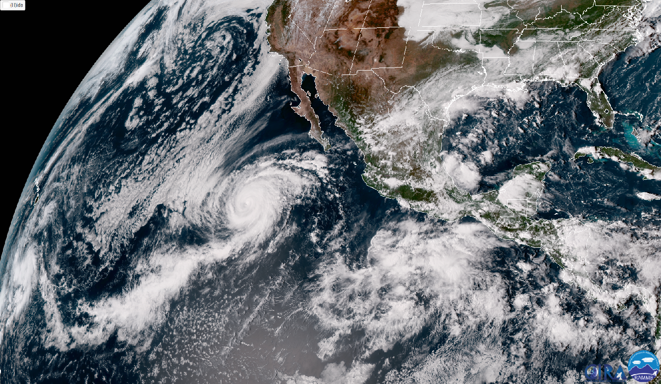
I know this is the Texas thread, but yowza  look at Arizona! I’ve never seen those colors before over the desert.
2 likes

Re: Texas Fall 2018
Buzz in the weather world is that the Euro will be running an additional 2x like the GFS. As if we weren't addicted to models enough as it is.
3 likes
The above post and any post by Ntxw is NOT an official forecast and should not be used as such. It is just the opinion of the poster and may or may not be backed by sound meteorological data. It is NOT endorsed by any professional institution including Storm2k. For official information, please refer to NWS products.
Help support Storm2K!
-
Haris

- Category 5

- Posts: 1814
- Joined: Mon Nov 27, 2017 8:19 pm
- Location: ( Bee Cave) West Austin, Texas
Re: Texas Fall 2018
Ntxw wrote:Buzz in the weather world is that the Euro will be running an additional 2x like the GFS. As if we weren't addicted to models enough as it is.
I know right!? RIP my focus even more on daily errands
0 likes
Weather geek and a storm spotter in West Austin. Not a degreed meteorologist. Big snow fan. Love rain and cold! Despise heat!
-
South Texas Storms

- Professional-Met

- Posts: 4256
- Joined: Thu Jun 24, 2010 12:28 am
- Location: Houston, TX
Re: Texas Fall 2018
As Ntxw mentioned in the ENSO thread, El Nino is arriving across the Pacific. Should keep the active pattern in place across TX over the next several months. Bring it on!
5 likes
-
weatherdude1108
- Category 5
- Posts: 4228
- Joined: Tue Dec 13, 2011 1:04 pm
- Location: Northwest Austin/Cedar Park, TX
Re: Texas Fall 2018
Cpv17 wrote:I know this is the Texas thread, but yowza
https://www.tropicaltidbits.com/analysis/models/gfs/2018092800/gfs_apcpn_us_52.png
That's a crazy amount of rain for that part of the world!
0 likes
The preceding post is NOT an official forecast, and should not be used as such. It is only the opinion of the poster and may or may not be backed by sound meteorological data. It is NOT endorsed by any professional institution including storm2k.org. For Official Information please refer to the NHC and NWS products.
-
Yukon Cornelius
- S2K Supporter

- Posts: 1842
- Age: 42
- Joined: Thu Dec 20, 2012 9:23 pm
- Location: Dean, TX/Westcliffe, CO
Re: Texas Fall 2018
South Texas Storms wrote:As Ntxw mentioned in the ENSO thread, El Nino is arriving across the Pacific. Should keep the active pattern in place across TX over the next several months. Bring it on!
Is the talk of a Modoki Nino still on the table?
0 likes
#neversummer
-
South Texas Storms
- Professional-Met
- Posts: 4256
- Joined: Thu Jun 24, 2010 12:28 am
- Location: Houston, TX
Re: Texas Fall 2018
Yukon Cornelius wrote:South Texas Storms wrote:As Ntxw mentioned in the ENSO thread, El Nino is arriving across the Pacific. Should keep the active pattern in place across TX over the next several months. Bring it on!
Is the talk of a Modoki Nino still on the table?
Yep, it sure is. Seems like a good chance of occurring this winter.
2 likes
Re: Texas Fall 2018
weatherdude1108 wrote:Cpv17 wrote:I know this is the Texas thread, but yowza
https://www.tropicaltidbits.com/analysis/models/gfs/2018092800/gfs_apcpn_us_52.png
That's a crazy amount of rain for that part of the world!
Indeed Rosa is adding to their totals. Our play card will be Sergio which could also be a big cane behind Rosa. Likely in the works of another heavy rain event.
El Nino is essentially here. The Ocean is finally caught up with tthe atmosphere. All Nino regions have warmed significantly. Generally Oct-Nov-Dec is the climax of Nino events.
2 likes
The above post and any post by Ntxw is NOT an official forecast and should not be used as such. It is just the opinion of the poster and may or may not be backed by sound meteorological data. It is NOT endorsed by any professional institution including Storm2k. For official information, please refer to NWS products.
Help support Storm2K!
Help support Storm2K!
-
Portastorm

- Storm2k Moderator

- Posts: 9955
- Age: 63
- Joined: Fri Jul 11, 2003 9:16 am
- Location: Round Rock, TX
- Contact:
Re: Texas Fall 2018
South Texas Storms wrote:Yukon Cornelius wrote:South Texas Storms wrote:As Ntxw mentioned in the ENSO thread, El Nino is arriving across the Pacific. Should keep the active pattern in place across TX over the next several months. Bring it on!
Is the talk of a Modoki Nino still on the table?
Yep, it sure is. Seems like a good chance of occurring this winter.
With this news and seeing what Ben Noll posted on Twitter this morning (he thinks the winter of 2014-15 is a decent analog), I am preparing for Austin to regain its claim to fame this winter season as the Freezing Drizzle Capital of Texas!
3 likes
Any forecasts under my name are to be taken with a grain of salt. Get your best forecasts from the National Weather Service and National Hurricane Center.
-
Haris
- Category 5
- Posts: 1814
- Joined: Mon Nov 27, 2017 8:19 pm
- Location: ( Bee Cave) West Austin, Texas
Re: Texas Fall 2018
12s gfs just fantastic for next weekend .
Very nice ensemble support too.
Man I’m loving this pattern!
Summer is gone 100% !
Very nice ensemble support too.
Man I’m loving this pattern!
Summer is gone 100% !
4 likes
Weather geek and a storm spotter in West Austin. Not a degreed meteorologist. Big snow fan. Love rain and cold! Despise heat!
-
TheProfessor

- Professional-Met
- Posts: 3506
- Age: 29
- Joined: Tue Dec 03, 2013 10:56 am
- Location: Wichita, Kansas
Re: Texas Fall 2018
I haven't been able to watch the Red River Rivalry in a while due to my own games I go to, but when's the last time the game has been a washout? My memory is a bit fuzzy but it always seems like the weather is always nice for that game lol.
0 likes
An alumnus of The Ohio State University.
Your local National Weather Service office is your best source for weather information.
Your local National Weather Service office is your best source for weather information.
-
Haris
- Category 5
- Posts: 1814
- Joined: Mon Nov 27, 2017 8:19 pm
- Location: ( Bee Cave) West Austin, Texas
Re: Texas Fall 2018


4 likes
Weather geek and a storm spotter in West Austin. Not a degreed meteorologist. Big snow fan. Love rain and cold! Despise heat!
-
weatherdude1108
- Category 5
- Posts: 4228
- Joined: Tue Dec 13, 2011 1:04 pm
- Location: Northwest Austin/Cedar Park, TX
Re: Texas Fall 2018
Attention-getter blurb at the end by EWX.
Bob Rose mentions a Canadian front next weekend.
EWX
000
FXUS64 KEWX 282008
AFDEWX
Area Forecast Discussion
National Weather Service Austin/San Antonio TX
308 PM CDT Fri Sep 28 2018
.SHORT TERM (Tonight through Saturday Night)...
Satellite-derived moisture products show quite the gradient in place
across central and southern Texas with precipitable water values
around 0.7" over the southern Edwards Plateau to near 2" along the
middle Texas coast. Some convection is ongoing across the coastal
plains and with moisture levels set to increase from south to north
overnight, we expect convection will gradually spread northward. Rain
chances will continue into Saturday with a continued supply of Gulf
moisture along with the presence of a weak shear axis/upper trough.
The best chance for rain will be along the coastal plains, where
moisture levels will be highest. Farther north and west, we should
still see at least scattered convection across the region.
&&
.LONG TERM (Sunday through Friday)...
Rain chances will continue on Sunday and Monday, but we expect a
slight decrease in rainfall chances as the weak upper trough/shear
axis begins to move east of the region. On Monday and Tuesday, the
subtropical ridge axis begins to build in from the east. We will see
a warming trend along with a low chance for mainly afternoon and
early evening convection, especially along the coastal plains. For
late in the upcoming work week, an upper level trough is expected to
approach from the west. A lead shortwave will approach on Thursday,
but any lift associated with this feature is expected to remain north
of our region. The medium range models suggest the main upper trough
will continue to deepen on Friday. We will continue to monitor the
progress of this upper trough as it could bring some active weather
to the region just beyond the current forecast period.
Bob Rose:
Computer-forecast solutions a call for a Canadian cold front to push south across the region next Saturday and Saturday night. There will be an area of rain showers and thunderstorms along and behind the cold front which could stretch into next Sunday. Slightly cooler weather conditions are expected beginning next Sunday. Rain amounts along the cold front are not shaping up to be all that heavy High temperatures behind the front are predicted to be around 80-82 degrees, with low temperatures in the upper 50s to low 60s.
https://www.lcra.org/water/river-and-we ... ather.aspx
1 likes
The preceding post is NOT an official forecast, and should not be used as such. It is only the opinion of the poster and may or may not be backed by sound meteorological data. It is NOT endorsed by any professional institution including storm2k.org. For Official Information please refer to the NHC and NWS products.
Re: Texas Fall 2018
We also have the brand new GOES 17 satellite for our viewing pleasure! It likely will becomes GOES west and have great views of the Pacific. Clearly visible is the very active tropical and subtropical Pacific, indicative of El Nino Falls. Should be exciting times here. If 2009 and 2014 are any hints, we could see some early winter in November.
But until then, the rain train is setting up with these Hurricanes.
But until then, the rain train is setting up with these Hurricanes.
3 likes
The above post and any post by Ntxw is NOT an official forecast and should not be used as such. It is just the opinion of the poster and may or may not be backed by sound meteorological data. It is NOT endorsed by any professional institution including Storm2k. For official information, please refer to NWS products.
Help support Storm2K!
Help support Storm2K!
Re: Texas Fall 2018
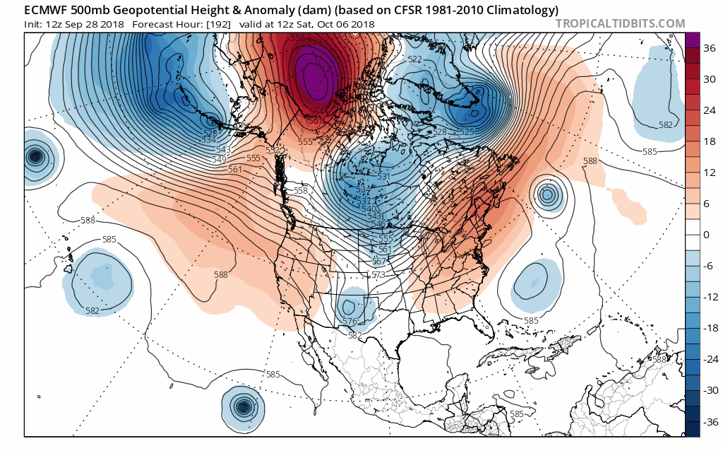
Also geeking out a little bit the big Pacific hurricanes has some mid latitude effects as well. Future Walaka (top left CPAC hurricane) near Hawaii should re-curve and fuse with the Aleutian trough amplifying more the Northeast Pacific ridge in place. Downstream that will merge Sergio with the westerlies and cutout a large trof in the west-central US in a little over a week.
3 likes
The above post and any post by Ntxw is NOT an official forecast and should not be used as such. It is just the opinion of the poster and may or may not be backed by sound meteorological data. It is NOT endorsed by any professional institution including Storm2k. For official information, please refer to NWS products.
Help support Storm2K!
Help support Storm2K!
-
TheProfessor
- Professional-Met
- Posts: 3506
- Age: 29
- Joined: Tue Dec 03, 2013 10:56 am
- Location: Wichita, Kansas
Re: Texas Fall 2018
2 likes
An alumnus of The Ohio State University.
Your local National Weather Service office is your best source for weather information.
Your local National Weather Service office is your best source for weather information.
Re: Texas Fall 2018
TheProfessor wrote::uarrow: That looks like a severe weather outbreak for the eastern plains and Ohio Valley.
Indeed, strong upper jet. Maybe a svr wx outbreak that way.
Same time could be a problematic flooding event in the southern plains.
3 likes
The above post and any post by Ntxw is NOT an official forecast and should not be used as such. It is just the opinion of the poster and may or may not be backed by sound meteorological data. It is NOT endorsed by any professional institution including Storm2k. For official information, please refer to NWS products.
Help support Storm2K!
Help support Storm2K!
Re: Texas Fall 2018
A few areas in SETX this morning have already exceeded 4” of rainfall with isolated totals of 7-9”. We might have gotten a quarter inch so far. The heavy stuff has been missing us every time as of late.
0 likes

Re: Texas Fall 2018
Got a heavy downpour last evening and again this morning, (still raining) nice to see these individual heavy showers moving right over the Rain Cave, as it always should IMO...
1 likes
Resident Rain Miser
I am a weather hobbyist living 3.5 miles south of Downtown Austin and in no way or fashion should anything I say concerning forecasts be taken seriously. Please check your local NWS for accurate weather forecasting and conditions.
I am a weather hobbyist living 3.5 miles south of Downtown Austin and in no way or fashion should anything I say concerning forecasts be taken seriously. Please check your local NWS for accurate weather forecasting and conditions.
Return to “USA & Caribbean Weather”
Who is online
Users browsing this forum: No registered users and 50 guests