Florida Weather
Moderator: S2k Moderators
Forum rules

The posts in this forum are NOT official forecast and should not be used as such. They are just the opinion of the poster and may or may not be backed by sound meteorological data. They are NOT endorsed by any professional institution or STORM2K.

-
gatorcane

- S2K Supporter

- Posts: 23708
- Age: 48
- Joined: Sun Mar 13, 2005 3:54 pm
- Location: Boca Raton, FL
Re: Florida Weather Thread: Rainy season continues
I really do like the guys at NWS Miami and they usually get it right -- but today was a blown forecast for sure. Numerous POPs developed across much over the CWA of Palm Beach, Broward, and Miami-Dade, especially Palm Beach, with copious amounts of rainfall across much of Palm Beach County. The forecast this AM said this (before all of the convection blew up):
AREA FORECAST DISCUSSION
NATIONAL WEATHER SERVICE MIAMI FL
950 AM EDT WED JUL 8 2009
.UPDATE...SOME MINOR ADJUSTMENTS WILL BE MADE TO CURRENT FORECAST
BASED ON LATEST OBSERVATIONS AND ANALYSIS. THE 12Z MFL SOUNDING
SHOWS SOME STABILIZATION HAS OCCURRED FROM 12 TO 24 HOURS AGO AND
WE HAD VERY LITTLE CONVECTION YESTERDAY. THE 50H TEMPERATURE HAS
WARMED CONSIDERABLY (AT LEAST BY SOUTH FLORIDA STANDARDS) AT 1
DEGREE CELSIUS AND JUST BY EYEBALLING THE SOUNDING ALSO REVEALS
THE LACK OF MID LAYER INSTABILITY WITH THE LAPSE RATE AT LESS THAN
7 DEGREES CELSIUS/KM. SOUTHWEST FLOW CONTINUES WITH DEEP LAYER
RIDGE STILL OVER THE FLORIDA STRAITS. HOWEVER, THE FLOW HAS
LESSENED WITH PRESSURE GRADIENT WEAKENING POSSIBLY AS A RESULT IN
SURFACE RIDGE SHIFTING NORTH EVER SO SLIGHTLY. THIS COULD ALLOW AN
EAST COAST SEA BREEZE TO SET UP WHICH WOULD ADD A LITTLE
CONVERGENCE TO THE PICTURE BUT AT THIS TIME JUST DOES NOT APPEAR
TO BE ENOUGH TO OVERCOME ABOVE ANALYSIS. SO IN STATING ALL OF
THIS, PLAN TO LOWER POPS TO JUST SLIGHT CHANCE ACROSS THE
NORTHEAST ZONE GROUPINGS. IF THE SEA BREEZE DOES SET UP, IT WILL
LIKELY BE QUITE LATE AND DOES NOT LOOK LIKE IT WILL AID MUCH
RELIEF TO THE RECENT VERY WARM AFTERNOON TEMPERATURES ALONG THE
EAST COAST SO STILL EXPECT NEAR RECORD MAXIMUM TEMPERATURES.
MARINE ZONES LOOK TO BE IN GOOD SHAPE SO NO CHANGES THERE WITH THE
EXCEPTION OF ALSO LOWERING POPS FOR THE ATLANTIC WATERS
0 likes
-
gatorcane
- S2K Supporter
- Posts: 23708
- Age: 48
- Joined: Sun Mar 13, 2005 3:54 pm
- Location: Boca Raton, FL
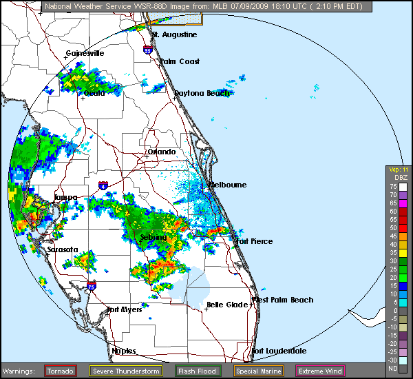
Looks like we have a training effect going on for most of Palm Beach county with excellent convergence:
http://radar.weather.gov/radar.php?rid= ... 1&loop=yes
I'm shocked a flood advisory has not been posted for Palm Beach County metro areas.
http://radar.weather.gov/radar.php?rid= ... 1&loop=yes
I'm shocked a flood advisory has not been posted for Palm Beach County metro areas.
0 likes
Re: Florida Weather Thread: Rainy season continues
Midnight: 85* and 82% humidity. Gulf's ready!
0 likes
-
Tampa Bay Hurricane

- Category 5

- Posts: 5597
- Age: 38
- Joined: Fri Jul 22, 2005 7:54 pm
- Location: St. Petersburg, FL
Re: Florida Weather Thread: Rainy season continues
Insane lightning! Really loud 10 bolts at least within a mile.
0 likes
Re: Florida Weather Thread: Rainy season continues
One week down and it has been an incredibly hot one so far in south florida...per NWS Miami, from July 1 - July 8, 2009:Avg High Miami: 92.9FAvg Low Miami: 77.6FAvg Temp Miami: 85.2FDeparture from Normal: +2.2F# Record Highs: 3# Record Max Lows: 1Current Water Temp Miami Beach: 87F
Last edited by jinftl on Thu Jul 09, 2009 1:59 pm, edited 2 times in total.
0 likes
-
HURAKAN

- Professional-Met

- Posts: 46084
- Age: 38
- Joined: Thu May 20, 2004 4:34 pm
- Location: Key West, FL
- Contact:
SPECIAL MARINE WARNING
NATIONAL WEATHER SERVICE MIAMI FL
234 PM EDT THU JUL 9 2009
THE NATIONAL WEATHER SERVICE IN MIAMI HAS ISSUED A
* SPECIAL MARINE WARNING FOR...
WESTERN LAKE OKEECHOBEE
* UNTIL 400 PM EDT
* AT 231 PM EDT...NATIONAL WEATHER SERVICE DOPPLER RADAR INDICATED A
LINE OF THUNDERSTORMS...CAPABLE OF PRODUCING STRONG WINDS OF 34
KNOTS OR GREATER FROM 18 NM NORTH OF LIBERTY POINT TO 8 NM
NORTHWEST OF LIBERTY POINT...MOVING NORTHEAST TO EAST AT 10 KNOTS.
* THESE STRONG THUNDERSTORMS WILL ALSO AFFECT
LIBERTY POINT...
LAKEPORT...
AND SURROUNDING COASTAL AREAS.
AS THUNDERSTORMS MOVE OVER THE WATER...BOATERS CAN EXPECT STRONG
GUSTY WINDS...HIGH WAVES...DANGEROUS LIGHTNING...AND HEAVY RAIN. MOVE
TO SAFE HARBOR OR STAY CLOSE TO SHORE UNTIL THE STORM PASSES. IF
CAUGHT ON THE OPEN WATER...MAKE SURE ALL SAFETY GEAR IS AVAILABLE AND
LIFE JACKETS ARE BEING WORN BY YOU AND YOUR CREW.
WATERSPOUTS CAN EASILY OVERTURN BOATS AND CREATE LOCALLY HAZARDOUS
SEAS. YOUR BEST COURSE OF EVASIVE ACTION IF THREATENED BY A
WATERSPOUT IS TO MOVE AT A 90 DEGREE ANGLE FROM ITS APPARENT
MOVEMENT. SEEK SAFE HARBOR IMMEDIATELY.
REPORT SEVERE WEATHER TO THE COAST GUARD. THEY WILL RELAY YOUR REPORT
TO THE NATIONAL WEATHER SERVICE FORECAST OFFICE IN MIAMI.
LAT...LON 2719 8073 2710 8065 2709 8065 2678 8092
2686 8111 2690 8112 2710 8095 2716 8087
2717 8087 2721 8083
TIME...MOT...LOC 1833Z 255DEG 7KT 2710 8091 2690 8109
0 likes
-
JonathanBelles
- Professional-Met
- Posts: 11430
- Age: 35
- Joined: Sat Dec 24, 2005 9:00 pm
- Location: School: Florida State University (Tallahassee, FL) Home: St. Petersburg, Florida
- Contact:
Re: Florida Weather Thread: Rainy season continues
Water temps around 90 in parts of Florida Bay and in areas southeast of Bimini

0 likes
Re: Florida Weather Thread: Rainy season continues
from miami morning discussion
THE 12Z MFL SOUNDING SHOWS VERY STRONG LOW LEVEL
INSTABILITY AND IN FACT THE VERTICAL TOTALS INDEX (WHICH IS A
MEASURE OF INSTABILITY FROM 85H TO 50H) IS THE HIGHEST I HAVE SEEN
IN THE 10 PLUS YEARS AT THIS OFFICE
that's impressive ......let's see if we get some breaks in the clouds by 1 or 2pm......
as you can see from this http://adds.aviationweather.gov/satelli ... &itype=vis lake area north ward has heating lets see if the breaks can push further SE
0 likes
Re: Florida Weather Thread: Rainy season continues
Cloud cover finally breaking up over south florida as we approach 4pm edt. Cloudcover has delayed the onset of any convection, but it will be interesting to see if storms can develop into the evening....temps around 90 now and plenty of instability so we may not get off rainfree today...it just may be in the evening instead of the afternoon.
Statewide, most convection is along and to the north of the I-4 corridor...as of now...

Statewide, most convection is along and to the north of the I-4 corridor...as of now...
0 likes
-
gatorcane
- S2K Supporter
- Posts: 23708
- Age: 48
- Joined: Sun Mar 13, 2005 3:54 pm
- Location: Boca Raton, FL
Kindaof interesting in this latest NWS Miami snippet:
ANOTHER VERY ODD FEATURE SHOWING UP IS SOME
FORM OF WEAK SURFACE BOUNDARY MOVING SOUTH OF LAKE OKEECHOBEE. YOU
CAN BARELY MAKE OUT THIS BOUNDARY ON VISIBLE SATELLITE IMAGERY AND
AS IT PASSED PBI THEIR WIND SHIFTED TO THE NORTHWEST. AM A LITTLE
PERPLEXED AS TO WHAT IS CAUSING THIS BOUNDARY SINCE IT DOES NOT
APPEAR ANYWHERE ELSE WITH OTHER SURFACE OBSERVATIONS, BUT
NONETHELESS IT IS THERE AND IT COULD INTERACT VERY EASILY WITH THE
EAST COAST SEA BREEZE.
http://forecast.weather.gov/product.php ... glossary=1
Indeed, back-to-back obs at PBI show this unexplained wind shift. Note no T-storms were in the area, just overcast skies:
10 12:53 NW 9 10.00 Overcast BKN150 OVC250 85 73 68% 30.12 1020.0
10 11:53 SE 13 10.00 Overcast BKN150 OVC250 83 73 72% 30.12 1020.0
10 10:53 E 10 10.00 Overcast BKN150 OVC250 84 74 72% 30.13 1020.4
0 likes
Re: Florida Weather Thread: Rainy season continues
Not that anyone needed reminding....but we are in full summer mode for sure, as measured by the low temps that are now being recorded in se fl and the keys...
Today's high/low temps:
Fort Lauderdale 91/80
Miami 89/81
Key West 89/84
Marathon 92/84
The 'lowest' low temp since July 4th has been 78 deg in Miami and Fort Laud....while Marathon in the Keys has been recording low temps between 82 and 84 deg every night since July 2! Month to date average high/low in Marathon is running a dubai-like 93/82!!!
0 likes
Re: Florida Weather Thread: Rainy season continues
Finally a wind from the SE today. First time in many weeks.
0 likes
Re: Florida Weather Thread: Rainy season continues
We haven't had any serious rain in a week and a half. We had a brief 5 minute shower last Sunday.
0 likes
-
HURRICANELONNY
- Category 5
- Posts: 1390
- Joined: Wed May 07, 2003 6:48 am
- Location: HOLLYWOOD.FL
Re: Florida Weather Thread: Rainy season continues
The east flow will become established this week on my side. your turn.
219 PM EDT sun Jul 12 2009
Discussion...the middle level ridging extending from North Texas to
Florida will weaken through Tuesday and then another middle level high
pressure ridging will build east from the Atlantic. This will
support a strengthening of the surface ridge as it builds west
from the open Atlantic to north of the County Warning Area. Deeper easterly flow
will start Tuesday with most activity over the west sections with
possible nocturnal convection over the Atlantic and east coastal
sections. An occasional weak disturbance could ride on the east
flow around the base of the ridge and approach the local area.
Temperatures and probability of precipitation will then be more like normal for this time of
year. Strength of thunderstorms will not be expected to be more than of
Special Weather Statement variety. Expect scattered probability of precipitation each afternoon and early
evening and widely scattered probability of precipitation at night and early morning hours
Atlantic.
0 likes
Re: Florida Weather Thread: Rainy season continues
Lowest overall rain chances than we have seen in weeks in southeast florida....rain chances range from 20-40% each day, highest as you move inland from the beaches. It's been dry in places already this month...and that should continue....Miami (airport) has seen less than half the normal month-to-date rain (1.10" actual through 7/12, normal for that period is 2.29").
HURRICANELONNY wrote:The east flow will become established this week on my side. your turn.
219 PM EDT sun Jul 12 2009
Discussion...the middle level ridging extending from North Texas to
Florida will weaken through Tuesday and then another middle level high
pressure ridging will build east from the Atlantic. This will
support a strengthening of the surface ridge as it builds west
from the open Atlantic to north of the County Warning Area. Deeper easterly flow
will start Tuesday with most activity over the west sections with
possible nocturnal convection over the Atlantic and east coastal
sections. An occasional weak disturbance could ride on the east
flow around the base of the ridge and approach the local area.
Temperatures and probability of precipitation will then be more like normal for this time of
year. Strength of thunderstorms will not be expected to be more than of
Special Weather Statement variety. Expect scattered probability of precipitation each afternoon and early
evening and widely scattered probability of precipitation at night and early morning hours
Atlantic.
0 likes
Return to “USA & Caribbean Weather”
Who is online
Users browsing this forum: No registered users and 27 guests