Memorial Day Weekend Outbreak 2008
Moderator: S2k Moderators
Forum rules

The posts in this forum are NOT official forecast and should not be used as such. They are just the opinion of the poster and may or may not be backed by sound meteorological data. They are NOT endorsed by any professional institution or STORM2K.

-
6SpeedTA95
- Category 5

- Posts: 1206
- Joined: Wed Oct 19, 2005 3:25 pm
- Location: Oklahoma
- Contact:
Re:
lilfish wrote:I just spoke to my parents who live in Ellis...there is no power. They also heard that semi-trailers were flipped on the interstate.
But they're safe?
0 likes


-
6SpeedTA95
- Category 5
- Posts: 1206
- Joined: Wed Oct 19, 2005 3:25 pm
- Location: Oklahoma
- Contact:
-
CrazyC83
- Professional-Met

- Posts: 34315
- Joined: Tue Mar 07, 2006 11:57 pm
- Location: Deep South, for the first time!
Re: Tornado outbreak again today?
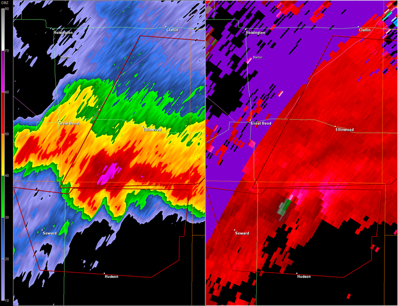
TORNADO WARNING
KSC009-159-240415-
/O.NEW.KICT.TO.W.0018.080524T0320Z-080524T0415Z/
BULLETIN - EAS ACTIVATION REQUESTED
TORNADO WARNING
NATIONAL WEATHER SERVICE WICHITA KS
1020 PM CDT FRI MAY 23 2008
THE NATIONAL WEATHER SERVICE IN WICHITA HAS ISSUED A
* TORNADO WARNING FOR...
NORTHWESTERN RICE COUNTY IN CENTRAL KANSAS.
SOUTHEASTERN BARTON COUNTY IN CENTRAL KANSAS.
* UNTIL 1115 PM CDT.
* AT 1019 PM CDT...NATIONAL WEATHER SERVICE METEOROLOGISTS WERE
TRACKING A TORNADO NEAR ELLINWOOD...OR 13 MILES SOUTHEAST OF GREAT
BEND...MOVING NORTHEAST AT 51 MPH.
* LOCATIONS WITHIN THE WARNING INCLUDE...
CHASE...ELLINWOOD...GENESEO...SILICA.
A LARGE AND DESTRUCTIVE TORNADO IS ON THE GROUND! MOVE INTO YOUR
TORNADO SHELTER NOW! IF NO UNDERGROUND SHELTER IS AVAILABLE...MOVE
INTO AN INTERIOR ROOM ON THE LOWEST FLOOR OF A STURDY STRUCTURE.
LEAVE AUTOMOBILES AND MOBILE HOMES...WHICH OFFER LITTLE PROTECTION
FROM A TORNADO.
LARGE HAIL AND DAMAGING THUNDERSTORM WINDS ARE ALSO EXPECTED WITH
THIS STORM.
A TORNADO WATCH REMAINS IN EFFECT UNTIL 400 AM CDT SATURDAY MORNING
FOR SOUTH CENTRAL KANSAS.
LAT...LON 3851 9859 3850 9840 3852 9812 3826 9846
3825 9876
TIME...MOT...LOC 0320Z 221DEG 44KT 3829 9857
$$
ES
0 likes
-
6SpeedTA95
- Category 5
- Posts: 1206
- Joined: Wed Oct 19, 2005 3:25 pm
- Location: Oklahoma
- Contact:
Return to “USA & Caribbean Weather”
Who is online
Users browsing this forum: HockeyTx82, SnowyOwl31 and 153 guests