Texas Summer 2012
Moderator: S2k Moderators
Forum rules

The posts in this forum are NOT official forecast and should not be used as such. They are just the opinion of the poster and may or may not be backed by sound meteorological data. They are NOT endorsed by any professional institution or STORM2K.
-
Rgv20

- S2K Supporter

- Posts: 2466
- Age: 39
- Joined: Wed Jan 05, 2011 5:42 pm
- Location: Edinburg/McAllen Tx
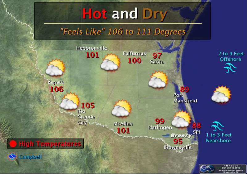
It is burning outside right now...As of 2pm its currently 101F at my backyard.
0 likes
The following post is NOT an official forecast and should not be used as such. It is just the opinion of the poster and may or may not be backed by sound meteorological data. It is NOT endorsed by any professional institution including storm2k.org For Official Information please refer to the NHC and NWS products.
-
Rgv20
- S2K Supporter
- Posts: 2466
- Age: 39
- Joined: Wed Jan 05, 2011 5:42 pm
- Location: Edinburg/McAllen Tx
Expected High for my area for Monday: 106F & Tuesday: 107F 
Heat Advisory
URGENT - WEATHER MESSAGE
NATIONAL WEATHER SERVICE BROWNSVILLE TX
655 PM CDT SUN JUN 10 2012
...DANGEROUSLY HOT WEATHER EXPECTED MONDAY AND TUESDAY...
.STRONG HIGH PRESSURE ALOFT WILL WORK WITH CLEAR SKIES AND
PLENTIFUL LOW LEVEL MOISTURE TO CREATE DANGEROUSLY HIGH AFTERNOON
HEAT INDICES ON MONDAY AND TUESDAY. HIGH HUMIDITY WILL ALSO KEEP
OVERNIGHT LOWS IN THE UPPER 70S TO LOW 80S ACROSS THE RIO GRANDE
VALLEY AND MUCH OF DEEP SOUTH TEXAS
TXZ248-251>257-111100-
/O.NEW.KBRO.HT.Y.0001.120611T1500Z-120613T0000Z/
ZAPATA-KENEDY-STARR-HIDALGO-INLAND WILLACY-INLAND CAMERON-
COASTAL WILLACY-COASTAL CAMERON-
INCLUDING THE CITIES OF...ZAPATA...SARITA...RIO GRANDE CITY...
ROMA...MCALLEN...EDINBURG...PHARR...MISSION...WESLACO...
RAYMONDVILLE...BROWNSVILLE...HARLINGEN...PORT MANSFIELD...
PORT ISABEL...SOUTH PADRE ISLAND...LAGUNA HEIGHTS...LAGUNA VISTA
655 PM CDT SUN JUN 10 2012
...HEAT ADVISORY IN EFFECT FROM 10 AM MONDAY TO 7 PM CDT
TUESDAY...
THE NATIONAL WEATHER SERVICE IN BROWNSVILLE HAS ISSUED A HEAT
ADVISORY FOR THE RIO GRANDE VALLEY AND PORTIONS OF DEEP SOUTH TEXAS...WHICH
IS IN EFFECT FROM 10 AM MONDAY TO 7 PM CDT TUESDAY.
* TIMING...BOTH MONDAY AND TUESDAY AFTERNOONS ARE EXPECTED TO SEE
HEAT INDEX VALUES IN THE 111 TO 114 DEGREE RANGE WHICH WILL
CREATE DANGEROUS CONDITIONS FOR OUTDOOR ACTIVITIES. OVERNIGHT LOWS IN
THE UPPER 70S TO LOW 80S WITH VERY HIGH HUMIDITY WILL PROVIDE
LITTLE OVERNIGHT RELIEF.
PRECAUTIONARY/PREPAREDNESS ACTIONS...
A HEAT ADVISORY IS ISSUED WHEN THE HEAT INDEX...A MEASURE OF HOW
IT FEELS WHEN TEMPERATURE AND HUMIDITY ARE COMBINED...EQUALS OR
EXCEEDS 111 FOR 2 HOURS OR MORE DURING THE DAY...AND OBSERVED
NIGHTTIME TEMPERATURES REMAIN 75 DEGREES OR ABOVE...FOR TWO
CONSECUTIVE DAYS OR MORE.
TAKE EXTRA PRECAUTIONS DURING THIS PARTICULARLY HOT PERIOD. BE SURE
TO CHECK ON PETS...THE ELDERLY...AND THOSE THAT MAY NOT HAVE
ACCESS TO COOLER TEMPERATURES INDOORS. THOSE THAT MUST WORK
OUTSIDE SHOULD TAKE FREQUENT BREAKS IN AIR CONDITIONED AREAS WHEN
POSSIBLE...STAY HYDRATED...AND TRY TO TIME ACTIVITY TO AVOID
WORKING IN THE HOTTEST PARTS OF THE DAY.
&&
$$
JGG/GB
0 likes
The following post is NOT an official forecast and should not be used as such. It is just the opinion of the poster and may or may not be backed by sound meteorological data. It is NOT endorsed by any professional institution including storm2k.org For Official Information please refer to the NHC and NWS products.
-
weatherdude1108
- Category 5

- Posts: 4228
- Joined: Tue Dec 13, 2011 1:04 pm
- Location: Northwest Austin/Cedar Park, TX
NWS ews Austin/San Antonio earlier discussion.
Side note: The Weather Channel mentions a 30% chance of thunderstorms early Tuesday evening, some severe. Probably an outlier.
"...issued 324 PM CDT sun Jun 10 2012/ Discussion... the morning upper air analysis shows a ridge above the boundary layer. At the surface high pressure is centered over the Gulf. Skies are mainly clear and combined with strong subsidence temperatures are climbing. All models are in good agreement that in the short term this pattern will stay in place. Not much change in the forecast for Monday and Tuesday. Continued hot with near record high temperatures. Tuesday night the upper ridge will weaken a bit and a weak front will drop into central Texas. Does not look like the front will make it as far south as our County Warning Area...but there is a slight chance for thunderstorms in our northern counties Tuesday night as the front passes to the north and east. This should bring some relief from the heat...although highs will still be above normal. The remainder of the forecast will be dominated by high pressure in the Gulf with overnight/morning cloudiness in the east and mostly sunny afternoons."
Also, the heat is on!
Record Report
Statement as of 5:40 PM CDT on June 10, 2012
... Record high temperature set at del Rio...
A record high temperature of 107 degrees was set at del Rio today.
This breaks the old record of 103 set in 1996.
Side note: The Weather Channel mentions a 30% chance of thunderstorms early Tuesday evening, some severe.
"...issued 324 PM CDT sun Jun 10 2012/ Discussion... the morning upper air analysis shows a ridge above the boundary layer. At the surface high pressure is centered over the Gulf. Skies are mainly clear and combined with strong subsidence temperatures are climbing. All models are in good agreement that in the short term this pattern will stay in place. Not much change in the forecast for Monday and Tuesday. Continued hot with near record high temperatures. Tuesday night the upper ridge will weaken a bit and a weak front will drop into central Texas. Does not look like the front will make it as far south as our County Warning Area...but there is a slight chance for thunderstorms in our northern counties Tuesday night as the front passes to the north and east. This should bring some relief from the heat...although highs will still be above normal. The remainder of the forecast will be dominated by high pressure in the Gulf with overnight/morning cloudiness in the east and mostly sunny afternoons."
Also, the heat is on!
Record Report
Statement as of 5:40 PM CDT on June 10, 2012
... Record high temperature set at del Rio...
A record high temperature of 107 degrees was set at del Rio today.
This breaks the old record of 103 set in 1996.
0 likes
The preceding post is NOT an official forecast, and should not be used as such. It is only the opinion of the poster and may or may not be backed by sound meteorological data. It is NOT endorsed by any professional institution including storm2k.org. For Official Information please refer to the NHC and NWS products.
-
SaskatchewanScreamer
If we can send winter to Bologna [youtube]http://www.youtube.com/watch?v=QgS7ELe31EA&feature=related[/youtube] surely we can get a low down to you folks......a cold breeze (for this time of year) is currently blowing in my windows so hopefully this will give that low a boost:
[youtube]http://www.youtube.com/watch?v=hIsKyf03ZwI[/youtube]
Hopefully it will only bring on rain.
[youtube]http://www.youtube.com/watch?v=hIsKyf03ZwI[/youtube]
Hopefully it will only bring on rain.
0 likes
-
vbhoutex

- Storm2k Executive

- Posts: 29145
- Age: 74
- Joined: Wed Oct 09, 2002 11:31 pm
- Location: Cypress, TX
- Contact:
Re: Texas Summer 2012
I sure hope it  works fast!!!! 89f and a feels like of 98f at 10:45am. Just finished a 2 mile walk and am DRENCHED!!
0 likes
Skywarn, C.E.R.T.
Please click below to donate to STORM2K to help with the expenses of keeping the site going:

Please click below to donate to STORM2K to help with the expenses of keeping the site going:
-
SaskatchewanScreamer
Your wish and my fans have picked up speed. The wind was very brisk at coffee time today (not overly fast but moving at a pretty good clip for a summer wind). Jack Frost or Old Man Winter had a hand in sending this......a definite hint of their icy touch is contained within.
Please send a *wee* bit of warmth up here (the humidity can go elsewhere)
Please send a *wee* bit of warmth up here (the humidity
0 likes
-
southerngale

- Retired Staff

- Posts: 27418
- Joined: Thu Oct 10, 2002 1:27 am
- Location: Southeast Texas (Beaumont area)
I've been in West Texas for the past week, and a quick trip to New Mexico. Apparently, we had one heck of a storm here because my yard was littered with debris and limbs when I got home early this morning. There was no rain out there and until the last couple of days, it was very cool. I should have brought a jacket. Lows in the upper 50s and highs in the 60s or low 70s much of the time. I guess I could have checked the weather before I left, but I just expected it to be hot. lol
0 likes
Please support Storm2k by making a donation today. It is greatly appreciated! Click here:
 my Cowboys my Rockets my Astros
my Cowboys my Rockets my Astros-
Portastorm

- Storm2k Moderator

- Posts: 9954
- Age: 63
- Joined: Fri Jul 11, 2003 9:16 am
- Location: Round Rock, TX
- Contact:
Re: Texas Summer 2012
At 3 pm, Austin Mabry reports an air temp of 99 and a heat index of 106!
0 likes
Any forecasts under my name are to be taken with a grain of salt. Get your best forecasts from the National Weather Service and National Hurricane Center.
-
weatherdude1108
- Category 5
- Posts: 4228
- Joined: Tue Dec 13, 2011 1:04 pm
- Location: Northwest Austin/Cedar Park, TX
Re: Texas Summer 2012
Portastorm wrote:At 3 pm, Austin Mabry reports an air temp of 99 and a heat index of 106!
Really??
It's a crisp 37.22 here! Weird(?).
Oh wait, that's in Celsius.
0 likes
-
Texas Snowman

- Storm2k Moderator
- Posts: 6197
- Joined: Fri Jan 25, 2008 11:29 am
- Location: Denison, Texas
Big storms and good rains in the Red River Valley last night.
Close to an inch of rain at my house in northern Grayson County.
More severe storms building out west towards Wichita Falls and Abilene as we speak.
I'll take this June over last June any day of the week!
Close to an inch of rain at my house in northern Grayson County.
More severe storms building out west towards Wichita Falls and Abilene as we speak.
I'll take this June over last June any day of the week!
0 likes
The above post and any post by Texas Snowman is NOT an official forecast and should not be used as such. It is just the opinion of the poster and may or may not be backed by sound meteorological data. It is NOT endorsed by any professional institution including storm2k.org. For official information, please refer to NWS products.

Re:
Texas Snowman wrote:I'll take this June over last June any day of the week!
Yes! The fact that it is June and sun nearing it's peak while I'm still seeing green is amazing on any year nonetheless compared to last. A few were worried in April that we might repeat the drought but to get that you need months of excessive dry not just a few weeks of a non wet spell
0 likes
The above post and any post by Ntxw is NOT an official forecast and should not be used as such. It is just the opinion of the poster and may or may not be backed by sound meteorological data. It is NOT endorsed by any professional institution including Storm2k. For official information, please refer to NWS products.
Help support Storm2K!
-
weatherdude1108
- Category 5
- Posts: 4228
- Joined: Tue Dec 13, 2011 1:04 pm
- Location: Northwest Austin/Cedar Park, TX
I love it!:D Even though we are in a dry rut here in central/south-central Texas and the lakes are lower than they were last year at this time, it is much greener and the wildflowers are still blooming all over the place! It feels different.
Here's hoping the infamous Austin heat bubble barrier breaks to let these storms in; or a gust front from these storms doesn't mess things up for us. I can't count the number of times I have seen that happen.
AREA FORECAST DISCUSSION
NATIONAL WEATHER SERVICE AUSTIN/SAN ANTONIO TX
304 PM CDT TUE JUN 12 2012
.DISCUSSION...
STRONG CONVECTIVE DEVELOPMENTS MOVING SOUTH ACROSS CENTRAL TEXAS AT
MID AFTERNOON WILL CONTINUE TO WORK THEIR WAY SOUTH SOUTHEAST INTO
CENTRAL TEXAS TOWARDS LATE AFTERNOON. LOOKS LIKE THEY WILL BE
MAINTAINED IN THE TEETH OF THE LOW LEVEL SOUTHERLY FLOW WITH
DEWPOINTS IN THE 70S...MOVING INTO AN ENVIRONMENT IN WHICH THERE
WILL BE RESULTANTLY HIGH CAPES (GREATER THAN 3000 J/KG).
THUS...PROPAGATION OF STRONG TO SEVERE STORMS ARE FORECAST INTO
OUR NORTHERN CWA BY LATE AFTERNOON. THESE STORMS WILL CONTINUE TO
PROPAGATE SOUTH AND EVEN TO THE SOUTHWEST THIS EVENING AS THE
AIRMASS TO THE EAST COOLS AND SOUTH TO SOUTHEAST WINDS INCREASE
WITH THE INCREASING LOW LEVEL PRESSURE GRADIENT. THE MAIN THREAT
WILL BE DAMAGING WINDS BUT CANNOT RULE OUT LARGE HAIL AND AN
ISOLATED TORNADO WITH RIGHT MOVING SUPER-CELL FORECAST MOVEMENT
SOUTHWEST IN THE DIRECTION OF HIGH CAPE. THE MCS SHOULD BE
DIMINISHING OVERNIGHT WITH SOME RESIDUAL SHOWERS OVER SOUTHERN AND
EASTERN SECTIONS TOMORROW. HEIGHTS ALOFT SHOULD LOWER TOMORROW
BUT WITHOUT ANY ORGANIZED LOW LEVEL BOUNDARIES...ORGANIZED
CONVECTION OTHER THAN RESIDUAL SHOWERS AND SEA BREEZE ACTIVITY ARE
EXPECTED. THE LOWERED FORECAST HEIGHTS WILL ALSO LOWER HIGH
TEMPERATURES A FEW DEGREES FROM WHAT THEY WERE TODAY...STILL
SLIGHTLY ABOVE NORMAL FOR THIS TIME OF YEAR. A CONTINUED GRADUAL
LOWERING OF HEIGHTS ALOFT THROUGH THE LATTER HALF OF THE WEEK WILL
MEAN HIGH TEMPERATURES RETURNING TO NORMAL LEVELS. AS THE CENTER
OF THE UPPER RIDGE MIGRATES INTO THE MIDWEST U.S. LATE IN THE
WEEK...EASTERLIES BECOME DOMINANT OVER THE GULF...INCREASING THE
CHANCES FOR SEA BREEZE CONVECTION MAKING IT INTO OUR CWA. BY
FRIDAY...HEIGHTS ALOFT WILL DECREASE ENOUGH FOR SOME SEA BREEZE
CONVECTION WORKING ITS WAY INTO OUR SOUTHEAST CWA. DITTO ON
SATURDAY AS SEA BREEZE CONVECTION IS AGAIN POSSIBLE MAINLY OVER
EASTERN PORTIONS. THE UPPER RIDGE BUILDS BACK LATE IN THE WEEKEND
PERIOD SO SUNDAY`S HIGHS WILL RISE AGAIN TO SLIGHTLY ABOVE
SEASONAL LEVELS...WITH SOME SEA BREEZE ACTIVITY AGAIN POSSIBLE
ALONG THE COASTAL PRAIRIES. ANOTHER DISTURBANCE MAY SKIRT OUR
NORTHERN CWA EARLY NEXT WEEK (TUESDAY) BUT TOO EARLY TO TELL
WHETHER OR NOT THE SYSTEM WILL DIG FAR ENOUGH TO AFFECT US.
Here's hoping the infamous Austin heat bubble barrier breaks to let these storms in; or a gust front from these storms doesn't mess things up for us.
I can't count the number of times I have seen that happen. AREA FORECAST DISCUSSION
NATIONAL WEATHER SERVICE AUSTIN/SAN ANTONIO TX
304 PM CDT TUE JUN 12 2012
.DISCUSSION...
STRONG CONVECTIVE DEVELOPMENTS MOVING SOUTH ACROSS CENTRAL TEXAS AT
MID AFTERNOON WILL CONTINUE TO WORK THEIR WAY SOUTH SOUTHEAST INTO
CENTRAL TEXAS TOWARDS LATE AFTERNOON. LOOKS LIKE THEY WILL BE
MAINTAINED IN THE TEETH OF THE LOW LEVEL SOUTHERLY FLOW WITH
DEWPOINTS IN THE 70S...MOVING INTO AN ENVIRONMENT IN WHICH THERE
WILL BE RESULTANTLY HIGH CAPES (GREATER THAN 3000 J/KG).
THUS...PROPAGATION OF STRONG TO SEVERE STORMS ARE FORECAST INTO
OUR NORTHERN CWA BY LATE AFTERNOON. THESE STORMS WILL CONTINUE TO
PROPAGATE SOUTH AND EVEN TO THE SOUTHWEST THIS EVENING AS THE
AIRMASS TO THE EAST COOLS AND SOUTH TO SOUTHEAST WINDS INCREASE
WITH THE INCREASING LOW LEVEL PRESSURE GRADIENT. THE MAIN THREAT
WILL BE DAMAGING WINDS BUT CANNOT RULE OUT LARGE HAIL AND AN
ISOLATED TORNADO WITH RIGHT MOVING SUPER-CELL FORECAST MOVEMENT
SOUTHWEST IN THE DIRECTION OF HIGH CAPE. THE MCS SHOULD BE
DIMINISHING OVERNIGHT WITH SOME RESIDUAL SHOWERS OVER SOUTHERN AND
EASTERN SECTIONS TOMORROW. HEIGHTS ALOFT SHOULD LOWER TOMORROW
BUT WITHOUT ANY ORGANIZED LOW LEVEL BOUNDARIES...ORGANIZED
CONVECTION OTHER THAN RESIDUAL SHOWERS AND SEA BREEZE ACTIVITY ARE
EXPECTED. THE LOWERED FORECAST HEIGHTS WILL ALSO LOWER HIGH
TEMPERATURES A FEW DEGREES FROM WHAT THEY WERE TODAY...STILL
SLIGHTLY ABOVE NORMAL FOR THIS TIME OF YEAR. A CONTINUED GRADUAL
LOWERING OF HEIGHTS ALOFT THROUGH THE LATTER HALF OF THE WEEK WILL
MEAN HIGH TEMPERATURES RETURNING TO NORMAL LEVELS. AS THE CENTER
OF THE UPPER RIDGE MIGRATES INTO THE MIDWEST U.S. LATE IN THE
WEEK...EASTERLIES BECOME DOMINANT OVER THE GULF...INCREASING THE
CHANCES FOR SEA BREEZE CONVECTION MAKING IT INTO OUR CWA. BY
FRIDAY...HEIGHTS ALOFT WILL DECREASE ENOUGH FOR SOME SEA BREEZE
CONVECTION WORKING ITS WAY INTO OUR SOUTHEAST CWA. DITTO ON
SATURDAY AS SEA BREEZE CONVECTION IS AGAIN POSSIBLE MAINLY OVER
EASTERN PORTIONS. THE UPPER RIDGE BUILDS BACK LATE IN THE WEEKEND
PERIOD SO SUNDAY`S HIGHS WILL RISE AGAIN TO SLIGHTLY ABOVE
SEASONAL LEVELS...WITH SOME SEA BREEZE ACTIVITY AGAIN POSSIBLE
ALONG THE COASTAL PRAIRIES. ANOTHER DISTURBANCE MAY SKIRT OUR
NORTHERN CWA EARLY NEXT WEEK (TUESDAY) BUT TOO EARLY TO TELL
WHETHER OR NOT THE SYSTEM WILL DIG FAR ENOUGH TO AFFECT US.
0 likes
The preceding post is NOT an official forecast, and should not be used as such. It is only the opinion of the poster and may or may not be backed by sound meteorological data. It is NOT endorsed by any professional institution including storm2k.org. For Official Information please refer to the NHC and NWS products.
-
Portastorm
- Storm2k Moderator
- Posts: 9954
- Age: 63
- Joined: Fri Jul 11, 2003 9:16 am
- Location: Round Rock, TX
- Contact:
Re: Texas Summer 2012
Based on the radar trends I see at 4:10 pm, get ready to be disappointed once again. Most of the cells look to be moving northwest to southeast and to the north of the AUS metro area.
0 likes
Any forecasts under my name are to be taken with a grain of salt. Get your best forecasts from the National Weather Service and National Hurricane Center.
-
Rgv20
- S2K Supporter
- Posts: 2466
- Age: 39
- Joined: Wed Jan 05, 2011 5:42 pm
- Location: Edinburg/McAllen Tx
I post it this on the Global Model Runs Thread in the Tropics but I think it belongs in here too.
Brownsville afternoon discussion.
.LONG TERM.../THURSDAY THROUGH TUESDAY/...MID LEVEL HIGH OVER
NORTHERN MEXICO WILL STILL BE THE DOMINANT WEATHER FACTOR FOR THE
REMAINDER OF THE WEEK. HOWEVER...BY THE END OF THE WEEK...ITS
INFLUENCE OVER DEEP SOUTH TEXAS WILL GRADUALLY BECOME LESS AS AN
UPPER LOW DEEPENS ACROSS BAJA MEXICO AND THE RIDGE AMPLIFIES AND
MOVES NORTHEAST INTO THE MIDWEST PORTION OF THE US. MEANWHILE DEEPER
TROPICAL MOISTURE WILL INCREASE AS A TROPICAL DISTURBANCE AND AREA
OF LOW PRESSURE MAKES ITS WAY INTO THE BAY OF CAMPECHE BY SATURDAY.
IF THIS SCENARIO PANS OUT...EASTERLY SURFACE FLOW AND DEEPER
TROPICAL MOISTURE WILL BRING ABOUT A CHANCE FOR SHOWERS OVER THE
WEEKEND. CONFIDENCE STILL NOT ALL THAT HIGH...BUT MODELS HAVE
PERSISTED WITH THIS SOLUTIONS FOR A COUPLE OF RUNS NOW. ANOTHER
TROPICAL SYSTEM MAY MAKE ITS WAY INTO THE GULF BY LATE NEXT WEEK.
BOTTOM LINE IS THE GULF BEARS WATCHING OVER THE NEXT WEEK OR TWO.
0 likes
The following post is NOT an official forecast and should not be used as such. It is just the opinion of the poster and may or may not be backed by sound meteorological data. It is NOT endorsed by any professional institution including storm2k.org For Official Information please refer to the NHC and NWS products.
-
Portastorm
- Storm2k Moderator
- Posts: 9954
- Age: 63
- Joined: Fri Jul 11, 2003 9:16 am
- Location: Round Rock, TX
- Contact:
Re: Texas Summer 2012
Portastorm wrote:Based on the radar trends I see at 4:10 pm, get ready to be disappointed once again. Most of the cells look to be moving northwest to southeast and to the north of the AUS metro area.
Well, EWX seems a little more bullish on the rain chances this evening. We shall see. With all of these outflow boundaries around, I guess our chances are better this evening than they have been.
0 likes
Any forecasts under my name are to be taken with a grain of salt. Get your best forecasts from the National Weather Service and National Hurricane Center.
-
Texas Snowman
- Storm2k Moderator
- Posts: 6197
- Joined: Fri Jan 25, 2008 11:29 am
- Location: Denison, Texas
Yeah, I haven't really been paying attention to the tropics until today, but from what I understand on "Talking Tropics," the tropical models are showing an E-Pac system making it into the BOC.
Also showing some sort of potential system developing in the SW Carib.
Hopefully some tropical moisture will come into play pretty soon and bring some showers/storms/rain for South and SE Texas.
Also showing some sort of potential system developing in the SW Carib.
Hopefully some tropical moisture will come into play pretty soon and bring some showers/storms/rain for South and SE Texas.
0 likes
The above post and any post by Texas Snowman is NOT an official forecast and should not be used as such. It is just the opinion of the poster and may or may not be backed by sound meteorological data. It is NOT endorsed by any professional institution including storm2k.org. For official information, please refer to NWS products.
-
Texas Snowman
- Storm2k Moderator
- Posts: 6197
- Joined: Fri Jan 25, 2008 11:29 am
- Location: Denison, Texas
Good rains and storms today in the southern portions of North Texas. Some of that is now moving into the Pineywoods.
And there is hope for more North Texas rains overnight and into tomorrow as per Fort Worth NWS:
FOR TONIGHT...NEW CONVECTION FIRING UPSTREAM IN THE NEW
MEXICO/COLORADO ROCKIES IS EXPECTED TO MOVE SOUTHEAST INTO THE
PANHANDLE THIS EVENING AND DEVELOP INTO AN MCS. THIS WILL EVENTUALLY
WORK INTO THE WESTERN CWA NEAR DAYBREAK AND ACROSS THE REMAINING
CWA WEDNESDAY MORNING THROUGH MIDDAY OR EARLY AFTERNOON. ONCE
AGAIN...DEPENDING ON HOW MUCH THE AIR GETS WORKED OVER...ENOUGH
INSTABILITY MAY REMAIN FOR A FEW STRONG TO SEVERE THUNDERSTORMS.
WE WILL LINGER LOW POPS ACROSS THE CWA WEDNESDAY AFTERNOON AS
OUTFLOW BOUNDARIES MAY BE PRESENT AND BECOME THE FOCUS FOR LOW
LEVEL CONVERGENCE AND STORM DEVELOPMENT."
0 likes
The above post and any post by Texas Snowman is NOT an official forecast and should not be used as such. It is just the opinion of the poster and may or may not be backed by sound meteorological data. It is NOT endorsed by any professional institution including storm2k.org. For official information, please refer to NWS products.
-
northjaxpro

- S2K Supporter
- Posts: 8900
- Joined: Mon Sep 27, 2010 11:21 am
- Location: Jacksonville, FL
Here is something I found today from the Beaumont Enterprise. Just something for you all over on the Texas coast to keep a watch as the GFS 10 day long range suggests something may be brewing.
Link:
http://www.beaumontenterprise.com/news/ ... 627425.php
Link:
http://www.beaumontenterprise.com/news/ ... 627425.php
Last edited by northjaxpro on Tue Jun 12, 2012 6:42 pm, edited 1 time in total.
0 likes
NEVER, EVER SAY NEVER in the tropics and weather in general, and most importantly, with life itself!!
________________________________________________________________________________________
Fay 2008 Beryl 2012 Debby 2012 Colin 2016 Hermine 2016 Julia 2016 Matthew 2016 Irma 2017 Dorian 2019
________________________________________________________________________________________
Fay 2008 Beryl 2012 Debby 2012 Colin 2016 Hermine 2016 Julia 2016 Matthew 2016 Irma 2017 Dorian 2019
-
Rgv20
- S2K Supporter
- Posts: 2466
- Age: 39
- Joined: Wed Jan 05, 2011 5:42 pm
- Location: Edinburg/McAllen Tx
Looking at the 12zECMWF Ensemble Control Run it brings a lot of moisture to most of South and Southeast Texas beginning on Thursday June 21 thru Saturday June 23. In fact it even develops a 1004mb Low Near Tampico, MX.....I know its fairly long range but something to keep an eye on.
0 likes
The following post is NOT an official forecast and should not be used as such. It is just the opinion of the poster and may or may not be backed by sound meteorological data. It is NOT endorsed by any professional institution including storm2k.org For Official Information please refer to the NHC and NWS products.
-
weatherdude1108
- Category 5
- Posts: 4228
- Joined: Tue Dec 13, 2011 1:04 pm
- Location: Northwest Austin/Cedar Park, TX
Re: Texas Summer 2012
Portastorm wrote:Portastorm wrote:Based on the radar trends I see at 4:10 pm, get ready to be disappointed once again. Most of the cells look to be moving northwest to southeast and to the north of the AUS metro area.
Well, EWX seems a little more bullish on the rain chances this evening. We shall see. With all of these outflow boundaries around, I guess our chances are better this evening than they have been.
Yeah, had some thunder and decent cooling outflow winds here in far North Austin that knocked a few twigs down. Had about 20 big sprinkles. That is it. I think the outflow screwed us over again, as I watched development start again south and southeast of here.
0 likes
Return to “USA & Caribbean Weather”
Who is online
Users browsing this forum: No registered users and 125 guests