Current Weather at Dallas, Texas
Temp: 78°F (26°C)
Partly Cloudy
Humidity: 52%
Wind Speed: N 21.9 MPH G 33.4 (19 MPH G 29 KT)
Barometer: 29.96 in
Dewpoint: 59°F
Wind Chill: 78°F
Okay, I'm cold.

When's Summer coming back???
Moderator: S2k Moderators


Current Weather at Dallas, Texas
Temp: 78°F (26°C)
Partly Cloudy
Humidity: 52%
Wind Speed: N 21.9 MPH G 33.4 (19 MPH G 29 KT)
Barometer: 29.96 in
Dewpoint: 59°F
Wind Chill: 78°F


somethingfunny wrote:Current Weather at Dallas, Texas
Temp: 78°F (26°C)
Partly Cloudy
Humidity: 52%
Wind Speed: N 21.9 MPH G 33.4 (19 MPH G 29 KT)
Barometer: 29.96 in
Dewpoint: 59°F
Wind Chill: 78°F
Okay, I'm cold.
When's Summer coming back???
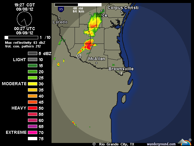
somethingfunny wrote:Cold front looks like it means business next weekend. I'm wondering if something spins up in the Gulf the following week as that front decays though.


Portastorm wrote::uarrow:
Funny!
OK, so gang ... was THIS the front we're talking about? Do we consider this one the first real front of the fall season, even though technically it is not fall yet? I'm inclined to say yes although I'm not 100% convinced. Thoughts? Comments?


vbhoutex wrote:Portastorm wrote::uarrow:
Funny!
OK, so gang ... was THIS the front we're talking about? Do we consider this one the first real front of the fall season, even though technically it is not fall yet? I'm inclined to say yes although I'm not 100% convinced. Thoughts? Comments?
Not at all convinced except the temperature only got up to 87 today instead of our "normal" upper 90s. I'll pass further judgement after I see the temps tomorrow and Monday.
Ntxw wrote:First half of Sept. -PNA and neutral NAO/AO will give us labor day heat. Nothing new right? Every year it seems. Isaac is the wildcard for wet in eastern Tx. CPC likes it warm and dry to start the month and I agree for almost everybody. I'm thinking a possible front by the 10th of Sept with a low swinging through the lakes to break the remaining ridge for us. Still seeing no direct tropical threats for Texas during that period from the Atlantic.
Portastorm wrote:We have the same "problem" in Austin as referenced above in Waco. The airport is located in a river valley and low temps on mornings like today (strong radiational cooling) are skewed compared to what the rest of the metro area experiences. For example, KAUS set a record low this morning of 52 degrees. However, the bulk of the Austin metro area bottomed out in the low 60s ... roughly 8 to 10 degrees of difference.
I just don't think the temps at KAUS sometimes represent what is really happening area-wide. That being said, the other reporting station is Camp Mabry (KATT) which is located in west central Austin. I noticed during the summer that the urban heat island effect sometimes would add a few degrees to the recorded high as compared to what they experienced at the airport. Another interesting way to experience this is to drive up and down Mopac. If your car has an accurate thermometer, you will often notice that in the middle of the day, the area around Camp Mabry (which is on the west side of Mopac) is often hotter than area further north or south.

Ntxw wrote:Ntxw wrote:First half of Sept. -PNA and neutral NAO/AO will give us labor day heat. Nothing new right? Every year it seems
Was a few days off and a little too aggressive with the cold front. Did deliver morning lows though! Latest CPC output is cooler than normal for the central part of the country the second half of the month. The PNA is forecasted to rise positive, this supports the cooler idea. For Texas I think we get a cold front once a week chipping away at temps slowly. Euro and GFS agrees.
CFSv2 is hinting at a start of persistent wet conditions for the state starting late this month. Analogs point to this scenario. The 5h pattern for North America is shifting into an EPO-/-AO configuration later this month. This should translate into a likely wet/cold October.


Return to “USA & Caribbean Weather”
Users browsing this forum: Google Adsense [Bot] and 178 guests
