Texas Spring 2018

U.S. & Caribbean Weather Discussions and Severe Weather Events

Moderator: S2k Moderators

Forum rules

The posts in this forum are NOT official forecast and should not be used as such. They are just the opinion of the poster and may or may not be backed by sound meteorological data. They are NOT endorsed by any professional institution or STORM2K.

Help Support Storm2K
Message
Author
User avatar
bubba hotep
S2K Supporter
S2K Supporter
Posts: 5609
Joined: Wed Dec 28, 2016 1:00 am
Location: Collin County Texas

Re: Texas Spring 2018

#601 Postby bubba hotep » Mon Apr 09, 2018 11:21 am

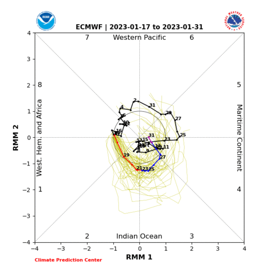
On the larger scale, we can tease out a few things about Friday by looking at the MJO & GWO. April MJO moving from P1 to P2 favors svr wx in East Texas with threat shifting eastward into the SE in P2. MJO P1 also sees a decrease in svr wx in West Texas.

Image

Then GWO in P1 & P2 is also favorable for svr wx.

Image

This combo points to a couple of svr wx days and probably also points to the faster positive tilted GFS solutions being wrong. However, it gives us little help in determining how much more the models might slow this system down other than it probably won't cutoff in the SW based on the pretty significant lack of svr wx in West Texas in MJO P1 in April.
0 likes   
Winter time post are almost exclusively focused on the DFW area.

User avatar
JDawg512
Category 5
Category 5
Posts: 1032
Age: 44
Joined: Mon Aug 26, 2013 8:56 pm
Location: Austin
Contact:

Re: Texas Spring 2018

#602 Postby JDawg512 » Mon Apr 09, 2018 11:26 am

weatherdude1108 wrote:It was chilly running the CAP10K yesterday in Austin! :cold:
But I managed to beat my best time by 8 minutes, despite temps in the 40s and cloudy. :wink: But I wore shorts and a long-sleeve shirt with a bandana. I debated between shorts and long exercise pants. The long pants would have been too warm, and I made the right call. All those people warmed it slightly, and I warmed up as I ran, even broke a sweat on my forehead about halfway through. :wink:

Of course it got sunny with highs in the upper 60s later in the day. Probably one of the colder 10Ks they have had in their history(?).


Congrats on running the 10K, I was considering signing up to run but decided to wait till next year as I am not quite ready and need more training.

59 degrees just before 1130a.m. Wondering if we will get into the upper 70s today depending on when the cloud deck breaks up.
1 likes   
Resident Rain Miser

I am a weather hobbyist living 3.5 miles south of Downtown Austin and in no way or fashion should anything I say concerning forecasts be taken seriously. Please check your local NWS for accurate weather forecasting and conditions.

User avatar
vbhoutex
Storm2k Executive
Storm2k Executive
Posts: 28979
Age: 72
Joined: Wed Oct 09, 2002 11:31 pm
Location: Spring Branch area, Houston, TX
Contact:

Re: Texas Spring 2018

#603 Postby vbhoutex » Mon Apr 09, 2018 11:54 am

JDawg512 wrote:
weatherdude1108 wrote:It was chilly running the CAP10K yesterday in Austin! :cold:
But I managed to beat my best time by 8 minutes, despite temps in the 40s and cloudy. :wink: But I wore shorts and a long-sleeve shirt with a bandana. I debated between shorts and long exercise pants. The long pants would have been too warm, and I made the right call. All those people warmed it slightly, and I warmed up as I ran, even broke a sweat on my forehead about halfway through. :wink:

Of course it got sunny with highs in the upper 60s later in the day. Probably one of the colder 10Ks they have had in their history(?).


Congrats on running the 10K, I was considering signing up to run but decided to wait till next year as I am not quite ready and need more training.

59 degrees just before 1130a.m. Wondering if we will get into the upper 70s today depending on when the cloud deck breaks up.

Congrats on the run JDawg!! An 8 minute improvement is impressive!!
You guys will have to run for this old dog no matter where it is. This old body won't handle it anymore. :x :(
BTW, has anyone found Spring? Apparently took a wrong turn Friday night and we haven't seen it since in Houston. :x
1 likes   
Skywarn, C.E.R.T.
Please click below to donate to STORM2K to help with the expenses of keeping the site going:
Image

User avatar
bubba hotep
S2K Supporter
S2K Supporter
Posts: 5609
Joined: Wed Dec 28, 2016 1:00 am
Location: Collin County Texas

Re: Texas Spring 2018

#604 Postby bubba hotep » Mon Apr 09, 2018 12:09 pm

From CIPS for Friday.

Image
0 likes   
Winter time post are almost exclusively focused on the DFW area.

User avatar
Haris
Category 5
Category 5
Posts: 1808
Joined: Mon Nov 27, 2017 8:19 pm
Location: ( Bee Cave) West Austin, Texas

Re: Texas Spring 2018

#605 Postby Haris » Mon Apr 09, 2018 12:26 pm

bubba hotep wrote:From CIPS for Friday.

http://www.eas.slu.edu/CIPS/SVRprob/201 ... ll_ALL.png


Do you personally think Austin area has a chance for some strong storms
0 likes   
Weather geek and a storm spotter in West Austin. Not a degreed meteorologist. Big snow fan. Love rain and cold! Despise heat!

weatherdude1108
Category 5
Category 5
Posts: 4174
Joined: Tue Dec 13, 2011 1:04 pm
Location: Northwest Austin/Cedar Park, TX

Re: Texas Spring 2018

#606 Postby weatherdude1108 » Mon Apr 09, 2018 2:36 pm

vbhoutex wrote:
JDawg512 wrote:
weatherdude1108 wrote:It was chilly running the CAP10K yesterday in Austin! :cold:
But I managed to beat my best time by 8 minutes, despite temps in the 40s and cloudy. :wink: But I wore shorts and a long-sleeve shirt with a bandana. I debated between shorts and long exercise pants. The long pants would have been too warm, and I made the right call. All those people warmed it slightly, and I warmed up as I ran, even broke a sweat on my forehead about halfway through. :wink:

Of course it got sunny with highs in the upper 60s later in the day. Probably one of the colder 10Ks they have had in their history(?).


Congrats on running the 10K, I was considering signing up to run but decided to wait till next year as I am not quite ready and need more training.

59 degrees just before 1130a.m. Wondering if we will get into the upper 70s today depending on when the cloud deck breaks up.

Congrats on the run JDawg!! An 8 minute improvement is impressive!!
You guys will have to run for this old dog no matter where it is. This old body won't handle it anymore. :x :(
BTW, has anyone found Spring? Apparently took a wrong turn Friday night and we haven't seen it since in Houston. :x


Thanks! :) I had been running 3 to 5 times a week and did several practice 10Ks. But I think my VivoFit is off. It showed I went 5.42 miles in the same time period. I pushed start at the start and stopped it at the finish. So in thinking I had been training for 10ks, I had been training for longer runs than a 10k I guess.lol

Yeah, Spring has been kind of a ghost this year. I'm wearing my light long sleeve shirt to work today. Usually we're well into the 80s by now. Not complaining! :)
1 likes   
The preceding post is NOT an official forecast, and should not be used as such. It is only the opinion of the poster and may or may not be backed by sound meteorological data. It is NOT endorsed by any professional institution including storm2k.org. For Official Information please refer to the NHC and NWS products.

User avatar
bubba hotep
S2K Supporter
S2K Supporter
Posts: 5609
Joined: Wed Dec 28, 2016 1:00 am
Location: Collin County Texas

Re: Texas Spring 2018

#607 Postby bubba hotep » Mon Apr 09, 2018 7:16 pm

Image
1 likes   
Winter time post are almost exclusively focused on the DFW area.

User avatar
TheProfessor
Professional-Met
Professional-Met
Posts: 3505
Age: 27
Joined: Tue Dec 03, 2013 10:56 am
Location: Wichita, Kansas

Re: Texas Spring 2018

#608 Postby TheProfessor » Mon Apr 09, 2018 7:37 pm

I'm not liking that map :uarrow:
0 likes   
An alumnus of The Ohio State University.

Your local National Weather Service office is your best source for weather information.

User avatar
dhweather
S2K Supporter
S2K Supporter
Posts: 6163
Joined: Sat Aug 14, 2004 9:29 pm
Location: Heath, TX
Contact:

Re: Texas Spring 2018

#609 Postby dhweather » Mon Apr 09, 2018 7:46 pm

My vantage point on Friday.

Image
2 likes   
The above post and any post by dhweather is NOT an official forecast and should not be used as such. It is just the opinion of the poster and may or may not be backed by sound meteorological data. It is NOT endorsed by any professional institution including storm2k.org. For official information, please refer to NWS products.

User avatar
bubba hotep
S2K Supporter
S2K Supporter
Posts: 5609
Joined: Wed Dec 28, 2016 1:00 am
Location: Collin County Texas

Re: Texas Spring 2018

#610 Postby bubba hotep » Mon Apr 09, 2018 7:46 pm

TheProfessor wrote:I'm not liking that map :uarrow:


Here is week 3 from the newest Euro Weeklies, you'll love this one lol

Image
3 likes   
Winter time post are almost exclusively focused on the DFW area.

Yukon Cornelius
S2K Supporter
S2K Supporter
Posts: 1738
Age: 40
Joined: Thu Dec 20, 2012 9:23 pm
Location: Dean, TX/Westcliffe, CO

Re: Texas Spring 2018

#611 Postby Yukon Cornelius » Tue Apr 10, 2018 3:11 pm

It was 39 years ago on this day, Tuesday, April 10th, 1979, the Red River Valley Outbreak produced 30 tornadoes. There were three main supercells. The first starting just south of Crowell at 3:05 p.m. This storm produced the tornado that devastated southeast Vernon and the tornado that caused severe damage to the southern portion of Lawton. Overall 56 people died.

Terrible Tuesday started with a deepening low near southeast Colorado. A warm front pushed north out of Central Texas with a low forming over Childress. There was plenty of moisture behind the warm front and a dryline formed.

The result was 30 tornadoes, two F-4 tornadoes, and the one known all too well to Wichita Falls residents causing 400 million dollars in damage, destroying over 3,000 homes, 1000 apartments, 140 mobile homes, 2 schools, over 100 commercial businesses.

The third of the three supercells produced the Wichita Falls tornado. The storm formed north of Abilene, tracked northeast, had a right turn as it produced the violent tornado many remember too well. At 6 p.m. the radar showed a classic supercell with a hook echo. The storm was well documented from the formation as it moved out of rural Archer and Wichita County and headed for Memorial Stadium and McNeil Junior High.

It quickly grew into a massive wedge with a damage path more than a mile wide. Ben Milam Elementary School was damaged. Cars were blown all around at the mall. An example of why you do not want to be caught in a car during a tornado. As the tornado moved into Clay County it became multi vortexed and caused damage near Dean and Byers.

According to the National Severe Storms Laboratory report by Don Burgess, 20,000 residents were left homeless, about 20% of the population.Inflation-adjusted the almost 900 million dollar disaster is the 10th costliest U.S. tornado on record. More than 40 died. According to the report, many people who took shelter in an interior room, low to the ground with mattresses and pillows may have been injured but they survived. Only five fatalities recorded were from inside a home. Many of the casualties came to those in cars.

The damage path of the Wichita Falls tornado was more than a mile wide and at the time was one of the biggest Ted Fujita said he had ever seen. We still look back on Terrible Tuesday for research. Damage from the Wichita Falls tornado was used to improve building construction and storm shelters.

It has been 23 years since a tornado death in Wichita County and almost 60 years in Clay County.
2 likes   
#neversummer
User avatar
wxman57
Moderator-Pro Met
Moderator-Pro Met
Posts: 22506
Age: 66
Joined: Sat Jun 21, 2003 8:06 pm
Location: Houston, TX (southwest)

Re: Texas Spring 2018

#612 Postby wxman57 » Tue Apr 10, 2018 7:55 pm

I was part of a chase team out of Texas A&M that tried to get to that supercell. Never made it. By the time we hit Waco there was no way we'd get there in time. Good think we missed it. Dangerous tornado.
6 likes   

Brent
S2K Supporter
S2K Supporter
Posts: 37143
Age: 35
Joined: Sun May 16, 2004 10:30 pm
Location: Tulsa Oklahoma
Contact:

Re: Texas Spring 2018

#613 Postby Brent » Tue Apr 10, 2018 10:21 pm

NAM barely out through Friday but has most of the action well east of us
0 likes   
#neversummer

User avatar
cheezyWXguy
Category 5
Category 5
Posts: 5566
Joined: Mon Feb 13, 2006 12:29 am
Location: Dallas, TX

Re: Texas Spring 2018

#614 Postby cheezyWXguy » Wed Apr 11, 2018 4:31 am

Brent wrote:NAM barely out through Friday but has most of the action well east of us


Not completely sold on this yet. 0z nam held the trough slightly further back and kept it a little stronger, and the 6z continued this trend. If this keeps up, I wouldn’t be surprised to see the enhanced risk shift West to I-35 in later outlooks
1 likes   

User avatar
bubba hotep
S2K Supporter
S2K Supporter
Posts: 5609
Joined: Wed Dec 28, 2016 1:00 am
Location: Collin County Texas

Re: Texas Spring 2018

#615 Postby bubba hotep » Wed Apr 11, 2018 6:51 am

cheezyWXguy wrote:
Brent wrote:NAM barely out through Friday but has most of the action well east of us


Not completely sold on this yet. 0z nam held the trough slightly further back and kept it a little stronger, and the 6z continued this trend. If this keeps up, I wouldn’t be surprised to see the enhanced risk shift West to I-35 in later outlooks


I tend to agree, here is the current D3

Image
0 likes   
Winter time post are almost exclusively focused on the DFW area.

User avatar
cheezyWXguy
Category 5
Category 5
Posts: 5566
Joined: Mon Feb 13, 2006 12:29 am
Location: Dallas, TX

Re: Texas Spring 2018

#616 Postby cheezyWXguy » Wed Apr 11, 2018 12:01 pm

12z nam continues the trend, and is The first run that shows hints of afternoon initiation just west of dfw
0 likes   

User avatar
South Texas Storms
Professional-Met
Professional-Met
Posts: 4033
Joined: Thu Jun 24, 2010 12:28 am
Location: Houston, TX

Re: Texas Spring 2018

#617 Postby South Texas Storms » Wed Apr 11, 2018 12:14 pm

cheezyWXguy wrote:12z nam continues the trend, and is The first run that shows hints of afternoon initiation just west of dfw


Not sure what you're seeing? 12z models so far have trended more progressive with the trough. Most show a band of showers moving eastward across the state Friday morning, with the thunderstorms holding off until far east TX during the afternoon.
1 likes   

User avatar
somethingfunny
ChatStaff
ChatStaff
Posts: 3926
Age: 35
Joined: Thu May 31, 2007 10:30 pm
Location: McKinney, Texas

Re: Texas Spring 2018

#618 Postby somethingfunny » Wed Apr 11, 2018 12:20 pm

A few miles' difference in the position of initialization along the dry line will make or break a severe weather and rain forecast for the Metroplex..... This reminds me of countless events with the freezing line hanging around just close enough to make a winter forecast impossible.
0 likes   
I am not a meteorologist, and any posts made by me are not official forecasts or to be interpreted as being intelligent. These posts are just my opinions and are probably silly opinions.

User avatar
cheezyWXguy
Category 5
Category 5
Posts: 5566
Joined: Mon Feb 13, 2006 12:29 am
Location: Dallas, TX

Re: Texas Spring 2018

#619 Postby cheezyWXguy » Wed Apr 11, 2018 12:27 pm

South Texas Storms wrote:
cheezyWXguy wrote:12z nam continues the trend, and is The first run that shows hints of afternoon initiation just west of dfw


Not sure what you're seeing? 12z models so far have trended more progressive with the trough. Most show a band of showers moving eastward across the state Friday morning, with the thunderstorms holding off until far east TX during the afternoon.

At 19z Fri on the 12z nam, i see a second, albeit weak, broken line of precip that was not there on prior runs.
0 likes   

User avatar
South Texas Storms
Professional-Met
Professional-Met
Posts: 4033
Joined: Thu Jun 24, 2010 12:28 am
Location: Houston, TX

Re: Texas Spring 2018

#620 Postby South Texas Storms » Wed Apr 11, 2018 12:29 pm

cheezyWXguy wrote:
South Texas Storms wrote:
cheezyWXguy wrote:12z nam continues the trend, and is The first run that shows hints of afternoon initiation just west of dfw


Not sure what you're seeing? 12z models so far have trended more progressive with the trough. Most show a band of showers moving eastward across the state Friday morning, with the thunderstorms holding off until far east TX during the afternoon.

At 19z Fri on the 12z nam, i see a second, albeit weak, broken line of precip that was not there on prior runs.


It still looks like the main severe risk area will be east of Dallas and closer to Tyler/Texarkana.

The trough will need to slow down for severe storms to fire closer to IH-35.
0 likes   


Return to “USA & Caribbean Weather”

Who is online

Users browsing this forum: No registered users and 55 guests