Texas Summer 2012

U.S. & Caribbean Weather Discussions and Severe Weather Events

Moderator: S2k Moderators

Forum rules

The posts in this forum are NOT official forecast and should not be used as such. They are just the opinion of the poster and may or may not be backed by sound meteorological data. They are NOT endorsed by any professional institution or STORM2K.

Help Support Storm2K
Message
Author
User avatar
vbhoutex
Storm2k Executive
Storm2k Executive
Posts: 29096
Age: 73
Joined: Wed Oct 09, 2002 11:31 pm
Location: Cypress, TX
Contact:

Re: Texas Summer 2012

#621 Postby vbhoutex » Tue Sep 11, 2012 7:58 pm

vbhoutex wrote:
vbhoutex wrote:
Portastorm wrote::uarrow:

Funny!

OK, so gang ... was THIS the front we're talking about? Do we consider this one the first real front of the fall season, even though technically it is not fall yet? I'm inclined to say yes although I'm not 100% convinced. Thoughts? Comments?

Not at all convinced except the temperature only got up to 87 today instead of our "normal" upper 90s. I'll pass further judgement after I see the temps tomorrow and Monday.

HHMMM??? Working on "cool" maybe. 65f low this am. Definitely dryer air. If we hit the official prediction for tomorrows low I will declare a "real" cool front in W. Houston, not cold though.

It was a REAL cool front. Quite refreshing! Can I order the last 3 days over and over for at least the next month with some rain thrown in for good measure?
0 likes   
Skywarn, C.E.R.T.
Please click below to donate to STORM2K to help with the expenses of keeping the site going:
Image

User avatar
horselattitudesfarm
Category 1
Category 1
Posts: 315
Joined: Thu Jul 16, 2009 5:55 pm
Location: Asheville, NC (formerly from Dallas, TX)

Re:

#622 Postby horselattitudesfarm » Tue Sep 11, 2012 10:25 pm

weatherdude1108 wrote:First mention of "El Nino" I have seen in the discussion. :)

AREA FORECAST DISCUSSION
NATIONAL WEATHER SERVICE AUSTIN/SAN ANTONIO TX
336 PM CDT TUE SEP 11 2012

.UPDATE...
/RESENT FOR CORRECTION TO PRELIMINARY NUMBERS/

&&

.PREV DISCUSSION... /ISSUED 322 PM CDT TUE SEP 11 2012/

DISCUSSION...
THE WEATHER PATTERN OVER TX THE NEXT FEW DAYS WILL BEGIN TO
REFLECT SOME OF THE POTENTIAL BENEFITS OF DEVELOPING EL NINO
CONDITIONS OVER THE PACIFIC FOR SEPTEMBER.
MOISTURE RETURN
ACCELERATES OVER SOUTH CENTRAL TX TONIGHT AS MID-LEVEL TROUGHING
CONTINUES TO DEVELOP OVER THE SWRN US. THE MODEL TRENDS CONTINUE
TO EXPAND ON RAIN CHANCES OVER A BROADER PERIOD WITH A WEAK COLD
FRONT STILL EXPECTED TO MOVE INTO THE REGION BY THURSDAY NIGHT.
THE FRONT IS NOT EXPECTED TO MAKE A STRONG PUSH THANKS TO
CONTINUED UPSTREAM DIGGING OF THE UPPER TROUGH. THE RESULT IS A
FAVORABLE SCENARIO FOR MESOSCALE CONVECTIVE SYSTEMS WHICH ARE
FIRST EXPECTED OVER WEST TX BY THURSDAY AFTERNOON AND INTO OUR WRN
COUNTIES THURSDAY EVENING. MODEL VARIABILITY STILL EXISTS FOR
TIMING AND BEST RAIN CHANCES...BUT THE MODEL TRENDS OF INCREASED
UPSTREAM TROUGHING SUGGEST BEST RAINFALL POTENTIAL OVER WESTERN
COUNTIES INITIALLY THURSDAY NIGHT WITH THE LATER PERIODS OF FRIDAY
AND SATURDAY FAVORING SOUTH AND EASTERN COUNTIES. GIVEN THIS
INCREASED TROUGHING TREND IN THE WESTERLIES...A SLIGHT MOISTURE TAP
WILL DEVELOP FROM THE UNSTABLE EASTERN PACIFIC TROPICS WHERE NHC
IS PROJECTING FAVORABLE CONDITIONS FOR A DEPRESSION NEAR 14N 102W.
INITIAL MOISTURE POOLING ALONG THE FRONT MAY NOT SUPPORT HEAVY
RAINS...BUT AN OVERRUNNING PATTERN AND CONTINUED DEEPENING OF THE
UPPER TROUGH COULD SUPPORT SCATTERED CONVECTION
OVER A BROAD AREA
OF SOUTH TX THROUGH AT LEAST DAYTIME SATURDAY. FOR THE PERIOD
THURSDAY AFTERNOON THROUGH SATURDAY AFTERNOON...WILL TAKE AN
AVERAGE OF MODEL SOLUTIONS AND EXPECT AREAL QPF AMOUNTS OF 1/4 TO
1/2 INCH WITH ISOLATED 1-2 INCH AMOUNTS.

ON SUNDAY THE SLIGHTLY MORE PROGRESSIVE AND DRIER GFS IS
PREFERRED WHICH CARRIES THE UPPER DISTURBANCE INTO E TX/LA. THE
PROGRESSIVE PATTERN SHOULD FAVOR SEASONAL TEMPERATURES AND A FAIR
AMOUNT OF RESIDUAL MOISTURE THAT COULD SUPPORT SOME CONVECTION
WHEN A WEAK DISTURBANCE DROPS SE ACROSS TX NEXT TUESDAY.

Ahhh, overrunning.....I remember those events fondly. Cool stratiform rain falling over lush green south texas winter rye.
0 likes   

User avatar
Rgv20
S2K Supporter
S2K Supporter
Posts: 2466
Age: 38
Joined: Wed Jan 05, 2011 5:42 pm
Location: Edinburg/McAllen Tx

#623 Postby Rgv20 » Tue Sep 11, 2012 11:30 pm

Looks like most of Texas is in for some wet weather! :D


0zGFS forecast Rainfall thru Sunday 7pm
Image


HPC forecast Rainfall thru Sunday 7pm
Image
0 likes   
The following post is NOT an official forecast and should not be used as such. It is just the opinion of the poster and may or may not be backed by sound meteorological data. It is NOT endorsed by any professional institution including storm2k.org For Official Information please refer to the NHC and NWS products.

User avatar
Ntxw
Storm2k Moderator
Storm2k Moderator
Posts: 22730
Joined: Wed Oct 21, 2009 6:34 pm
Location: DFW, Texas

#624 Postby Ntxw » Wed Sep 12, 2012 12:09 pm

Latest GFS seems to follow what the Euro has been trying to show. Obviously the -EPO/+PNA persistence, but also a southern stream cut off low train that begins this weekend. The shortwave will be slow to move out only to be followed by another one next week that arrives from the coast of California/Baja.

The strength and extent of the upcoming pattern sypnotics is very unusual. We don't tend to see this much amplification in the pattern until winter!
0 likes   
The above post and any post by Ntxw is NOT an official forecast and should not be used as such. It is just the opinion of the poster and may or may not be backed by sound meteorological data. It is NOT endorsed by any professional institution including Storm2k. For official information, please refer to NWS products.

  Help support Storm2K!
Help Support Storm2K

weatherdude1108
Category 5
Category 5
Posts: 4228
Joined: Tue Dec 13, 2011 1:04 pm
Location: Northwest Austin/Cedar Park, TX

Re:

#625 Postby weatherdude1108 » Wed Sep 12, 2012 5:53 pm

Ntxw wrote:Latest GFS seems to follow what the Euro has been trying to show. Obviously the -EPO/+PNA persistence, but also a southern stream cut off low train that begins this weekend. The shortwave will be slow to move out only to be followed by another one next week that arrives from the coast of California/Baja.

The strength and extent of the upcoming pattern sypnotics is very unusual. We don't tend to see this much amplification in the pattern until winter!


:uarrow:
Bring it!! :D
0 likes   

User avatar
Ntxw
Storm2k Moderator
Storm2k Moderator
Posts: 22730
Joined: Wed Oct 21, 2009 6:34 pm
Location: DFW, Texas

Re: Texas Summer 2012

#626 Postby Ntxw » Wed Sep 12, 2012 6:02 pm

HPC is upping the ante, radar is starting to show in west Texas.

Image

Image
0 likes   
The above post and any post by Ntxw is NOT an official forecast and should not be used as such. It is just the opinion of the poster and may or may not be backed by sound meteorological data. It is NOT endorsed by any professional institution including Storm2k. For official information, please refer to NWS products.


  Help support Storm2K!

Help Support Storm2K


User avatar
Rgv20
S2K Supporter
S2K Supporter
Posts: 2466
Age: 38
Joined: Wed Jan 05, 2011 5:42 pm
Location: Edinburg/McAllen Tx

#627 Postby Rgv20 » Wed Sep 12, 2012 9:14 pm

:uarrow: That HPC map looks very very close to the 12zECMWF QPF total.....Looking very wet for Texas :D
0 likes   
The following post is NOT an official forecast and should not be used as such. It is just the opinion of the poster and may or may not be backed by sound meteorological data. It is NOT endorsed by any professional institution including storm2k.org For Official Information please refer to the NHC and NWS products.

weatherdude1108
Category 5
Category 5
Posts: 4228
Joined: Tue Dec 13, 2011 1:04 pm
Location: Northwest Austin/Cedar Park, TX

#628 Postby weatherdude1108 » Thu Sep 13, 2012 8:42 am

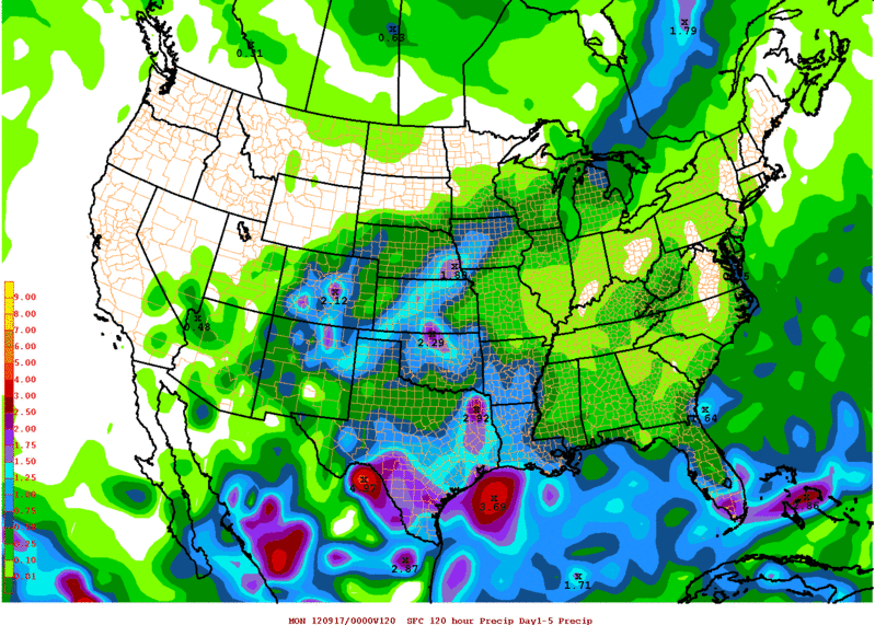
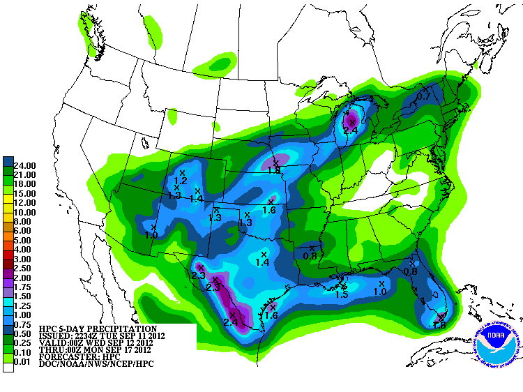
"MUCH NEEDED RAINS" were mentioned twice in the same discussion. :D :lightning: :rain:

.PREV DISCUSSION... /ISSUED 349 AM CDT THU SEP 13 2012/

DISCUSSION...
THE MUCH NEEDED RAINS ARE TO BE FELT ACROSS SOUTH CENTRAL TEXAS
LATER THIS MORNING AND AFTERNOON AS POST FRONTAL SHOWERS AND
THUNDERSTORMS DEVELOP ACROSS THE NORTHWEST GULF WATERS AND MOVE
ONSHORE ACROSS THE COASTAL PLAINS AND NORTHWARD.
CHANCES OF RAIN AND
THUNDERSTORMS WILL INCREASE THIS AFTERNOON/TONIGHT INTO FRIDAY AS
THE COLD FRONT MOVES ACROSS THE AREA.

AN UPPER LEVEL TROUGH EXTENDS FROM THE NORTHERN PLAINS SOUTHWESTWARD
TO THE FOUR CORNER STATES REGION WITH AN ASSOCIATED COLD FRONT
EXTENDING FROM THE GREAT LAKES SOUTHWESTWARD TO THE NORTHERN PORTION
OF TEXAS. THESE FEATURES WILL MOVE SOUTHEAST DURING THE DAY AND
BRING THE MUCH NEEDED RAINS OVER SOUTH CENTRAL TEXAS FOR THE NEXT
FEW DAYS.
MODELS ARE IN FAIR TO GOOD AGREEMENT ON THE INITIAL POSITION
AND FUTURE TRACK FOR THE NEXT 30 HOURS. HOWEVER...MODELS ARE HAVING
DIFFICULTIES TO RESOLVE ON A PIECE OF ENERGY THAT STAYS BEHIND OVER
NEW MEXICO SATURDAY. GFS IS A BIT FASTER THAN ECMWF MOVING THIS
PIECE OF ENERGY/SHORT WAVE TROUGHING FROM THE AREA LATE SUNDAY
MORNING VS ECMWF SUNDAY AFTERNOON. WILL GO WITH THE GFS SOLUTION PER
THIS PACKAGE ENDING POPS FROM WEST TO EAST BEGINNING LATE SUNDAY
MORNING OUT WEST AND ALONG AND EAST OF I35 BY SUNDAY AFTERNOON.

A CONVERGENCE ZONE PRIOR TO THE ARRIVAL OF THE FRONT IS EXPECTED TO
ENHANCE SHOWERS AND THUNDERSTORMS THIS AFTERNOON ACROSS THE NORTHERN
HILL COUNTRY ESPECIALLY THE EDWARDS PLATEAU AREA. FEW HOURS LATER...
BETWEEN 7 TO 9 PM CDT THIS EVENING...THE FRONT WILL MOVE ACROSS THE
UPPER RIO GRANDE PLAINS/EDWARDS PLATEAU AREA...9 PM TO MIDNIGHT
ALONG I35 TO NEAR AND SOUTH OF HIGHWAY 90 WEST OF SAN ANTONIO TO
DEL RIO AND MIDNIGHT TO 2 AM FRIDAY OVER THE SOUTHERN COUNTIES.
HEAVIEST RAINS ARE EXPECTED ACROSS THE UPPER RIO GRANDE
PLAINS/EDWARDS PLATEAU AREA TONIGHT. RAINFALL AMOUNTS COULD RANGE
FROM ONE HALF TO ONE INCH...WITH ISOLATED SPOTS HAVING HIGHER
AMOUNTS DURING THE PERIOD. AFTER MIDNIGHT...WIDE-SPREAD SHOWERS
AND THUNDERSTORMS WILL AFFECT MOST OF THE WESTERN HALF OF SOUTH
CENTRAL TEXAS WHILE EXPANDING ACROSS MOST OF THE AREA BY FRIDAY. ON SATURDAY...SHOWERS AND THUNDERSTORMS ARE EXPECTED TO RE-DEVELOP
ACROSS THE AREA AS UPPER SUPPORT REMAINS ACROSS THE REGION AND
FRONTAL BOUNDARY SITS ACROSS THE COASTAL PLAINS.
BY SUNDAY...UPPER
SUPPORT SHIFTS EASTWARD AS MENTIONED ABOVE AND RAIN CHANCES END
FROM WEST TO EAST.

ESTIMATED STORM RAINFALL AMOUNTS FROM THURSDAY AFTERNOON TO LATE
SUNDAY MORNING ARE EXPECTED TO RANGE FROM ONE TO THREE INCHES WITH
HIGHER AMOUNTS OVER ISOLATED AREAS.
SINCE THE RAIN CHANCES FOR SOUTH
CENTRAL TEXAS EXTEND FOR SEVERAL DAYS...THE MAIN THREAT FOR THIS
EVENT WILL BE MINOR FLOODING ACROSS STREETS...UNDERPASSES...
LOW LEVEL CROSSING AND SMALL RIVER CREEKS.

HIGHS AND LOWS WILL BE SLIGHTLY BELOW NORMAL VALUES TODAY AND BELOW
NORMAL AVERAGES FRIDAY INTO THE WEEKEND DUE TO CLOUDS AND RAIN
COVERAGE AND MODIFYING AIR MASS. FOR MONDAY AND TUESDAY...TEMPS ARE
EXPECTED TO BE NEAR OR SLIGHTLY BELOW SEASONAL AVERAGES.

NEXT FRONTAL BOUNDARY IS EXPECTED TO MOVE ACROSS THE AREA TUESDAY
WITH A SLIGHT OF RAIN/THUNDERSTORM MAINLY ACROSS THE NORTHEAST PART
OF SOUTH CENTRAL TEXAS.
0 likes   
The preceding post is NOT an official forecast, and should not be used as such. It is only the opinion of the poster and may or may not be backed by sound meteorological data. It is NOT endorsed by any professional institution including storm2k.org. For Official Information please refer to the NHC and NWS products.

User avatar
Rgv20
S2K Supporter
S2K Supporter
Posts: 2466
Age: 38
Joined: Wed Jan 05, 2011 5:42 pm
Location: Edinburg/McAllen Tx

#629 Postby Rgv20 » Thu Sep 13, 2012 8:52 am

Flood Advisory

FLOOD ADVISORY
NATIONAL WEATHER SERVICE BROWNSVILLE TX
814 AM CDT THU SEP 13 2012

TXC061-131615-
/O.NEW.KBRO.FA.Y.0081.120913T1314Z-120913T1615Z/
/00000.0.ER.000000T0000Z.000000T0000Z.000000T0000Z.OO/
CAMERON-
814 AM CDT THU SEP 13 2012

THE NATIONAL WEATHER SERVICE IN BROWNSVILLE HAS ISSUED AN

* URBAN AND SMALL STREAM FLOOD ADVISORY FOR MINOR FLOODING OF POOR
DRAINAGE AREAS IN...
CAMERON COUNTY IN DEEP SOUTH TEXAS.
THIS INCLUDES THE CITIES OF...OLMITO...LAURELES...HARLINGEN VALLEY
AIRPORT...SAN BENITO...PORT ISABEL...HARLINGEN...BROWNSVILLE

* UNTIL 1115 AM CDT

* AT 810 AM CDT...A CLUSTER OF SHOWERS AND THUNDERSTORMS WITH VERY
HEAVY RAINFALL WERE IMPACTING BROWNSVILLE...PORT ISABEL AND OTHER
AREAS OF THE LOWER RIO GRANDE VALLEY. THE STORMS WERE MOVING MOVING
NORTH AT 20 MPH. RAINFALL RATES OF UP TO 3 INCHES PER HOUR WERE
OCCURRING WITH THESE STORMS.


PRECAUTIONARY/PREPAREDNESS ACTIONS...

EXCESSIVE RUNOFF FROM THIS STORM WILL CAUSE FLOODING OF LOW LYING
AREAS AND INTERSECTIONS. MOTORISTS SHOULD EXERCISE CAUTION AND ALLOW
EXTRA TIME WHILE DRIVING.

DON`T BECOME A STATISTIC. TURN AROUND...DON`T DROWN!

&&

LAT...LON 2595 9714 2592 9735 2584 9737 2583 9743
2602 9769 2622 9778 2637 9732 2620 9726
2625 9729 2611 9729 2609 9727 2609 9722
2615 9724 2606 9718 2639 9722 2639 9721
2607 9712

$$

51
0 likes   
The following post is NOT an official forecast and should not be used as such. It is just the opinion of the poster and may or may not be backed by sound meteorological data. It is NOT endorsed by any professional institution including storm2k.org For Official Information please refer to the NHC and NWS products.

User avatar
Portastorm
Storm2k Moderator
Storm2k Moderator
Posts: 9914
Age: 62
Joined: Fri Jul 11, 2003 9:16 am
Location: Round Rock, TX
Contact:

Re: Texas Summer 2012

#630 Postby Portastorm » Thu Sep 13, 2012 11:07 am

The rain event appears to be unfolding as predicted. Showers are starting to light up the AUS radar just before lunchtime here. These smallish cells are moving northward, while the big blob of rain/convection from west-north Texas is also heading our way.

Happy! :D
0 likes   
Any forecasts under my name are to be taken with a grain of salt. Get your best forecasts from the National Weather Service and National Hurricane Center.

weatherdude1108
Category 5
Category 5
Posts: 4228
Joined: Tue Dec 13, 2011 1:04 pm
Location: Northwest Austin/Cedar Park, TX

Re: Texas Summer 2012

#631 Postby weatherdude1108 » Thu Sep 13, 2012 12:14 pm

Portastorm wrote:The rain event appears to be unfolding as predicted. Showers are starting to light up the AUS radar just before lunchtime here. These smallish cells are moving northward, while the big blob of rain/convection from west-north Texas is also heading our way.

Happy! :D


Had a nice, long, heavy shower at work about an hour ago. Very tropical warm rain at the moment! From the looks of the radar, looks like the Weatherdude Center may be getting light stuff right now. My 75-gallon rain barrel missed out on the rain last month because of a dirt clog in the line. But I think I fixed it. Prepped it before I left to make sure the Law of Gravity is in my favor. But like Portastorm said, the radar is lighting up and closing in on this area. Looks like different flavors of popcorn! :P

Happy as well! :D :rain: :lightning:
0 likes   

User avatar
Ntxw
Storm2k Moderator
Storm2k Moderator
Posts: 22730
Joined: Wed Oct 21, 2009 6:34 pm
Location: DFW, Texas

#632 Postby Ntxw » Thu Sep 13, 2012 12:16 pm

Felt the wind shift here in North Texas not too long ago. Either from the front or outflow either way it was drastic, DFW dropped from the mid 80s to mid 70s rather quickly. Radar estimates has 3-5 inches of rain already just west and widespread 2+.

FW thinks the heaviest rain will be along the I-35 corridor

Image
0 likes   
The above post and any post by Ntxw is NOT an official forecast and should not be used as such. It is just the opinion of the poster and may or may not be backed by sound meteorological data. It is NOT endorsed by any professional institution including Storm2k. For official information, please refer to NWS products.


  Help support Storm2K!

Help Support Storm2K


User avatar
iorange55
Category 5
Category 5
Posts: 2388
Joined: Thu Nov 13, 2008 9:47 pm
Location: Big D

Re: Texas Summer 2012

#633 Postby iorange55 » Thu Sep 13, 2012 1:50 pm

Who is the magician here and made all the rain disappear? :P

Hopefully we have better luck with the next wave...
0 likes   

User avatar
somethingfunny
ChatStaff
ChatStaff
Posts: 3926
Age: 36
Joined: Thu May 31, 2007 10:30 pm
Location: McKinney, Texas

Re: Texas Summer 2012

#634 Postby somethingfunny » Thu Sep 13, 2012 2:56 pm

iorange55 wrote:Who is the magician here and made all the rain disappear? :P

Hopefully we have better luck with the next wave...


It was me. I needed to mow the yard before it became all waterlogged. :wink:
0 likes   
I am not a meteorologist, and any posts made by me are not official forecasts or to be interpreted as being intelligent. These posts are just my opinions and are probably silly opinions.

User avatar
gboudx
S2K Supporter
S2K Supporter
Posts: 4080
Joined: Thu Sep 04, 2003 1:39 pm
Location: Rockwall, Tx but from Harvey, La

Re: Texas Summer 2012

#635 Postby gboudx » Thu Sep 13, 2012 3:22 pm

iorange55 wrote:Who is the magician here and made all the rain disappear? :P

Hopefully we have better luck with the next wave...


That was depressing to watch as the outflow boundary came in and all the rain behind it started falling apart. Now it's all south, west and east of DFW Metro. We're this giant hole right in the middle. Nice.
0 likes   

User avatar
horselattitudesfarm
Category 1
Category 1
Posts: 315
Joined: Thu Jul 16, 2009 5:55 pm
Location: Asheville, NC (formerly from Dallas, TX)

Re: Texas Summer 2012

#636 Postby horselattitudesfarm » Thu Sep 13, 2012 3:44 pm

Looks like DFW got screwed again and its not looking good according to the latest update on the discussion:

AMDAR SOUNDINGS FROM DAL AFTER FROPA SHOW A SATURATED COLUMN WITH
A MOIST ADIABATIC PROFILE. ALL IT WOULD TAKE TO GET RAIN FROM
THIS COLUMN IS FORCING. LOOKING AT THE GFS AND EURO POTENTIAL
VORTICITY PROGS...WE REALLY DON`T SEE ANY WIDESPREAD LIFT UNTIL
POSSIBLY EARLY SUNDAY WHEN THE UPPER FEATURE FINALLY ROTATES
THROUGH. BY THEN THE COLD FRONT WILL HAVE SCOURED OUT MUCH OF THE
MOISTURE.

WITH NO FORCING...CONVECTION WILL BE LESS ORGANIZED AND THUS MORE
SCATTERED THAN WE PREVIOUSLY FORECAST. BY THIS
EVENING...CONVECTION SHOULD BE ON THE DECREASE AS THE LOW LEVEL
FLOW FROM THE GULF SWITCHES FROM SOUTHEAST TO EAST...PUSHING THE
BEST MOISTURE TOWARDS THE RIO GRANDE VALLEY AND EDWARDS PLATEAU.
CANNOT RULE OUT PRECIP...BUT DO NOT EXPECT WIDESPREAD OR HEAVY
PRECIP LIKE WE SEE TODAY.

I'm feeling a dry and kinda dusty wind without that sweet sent of wet vegetation and moist soil. The clouds also are looking flat and kinda thin....a sure sign of sinking air. The funny thing is, I thought a cold front, and outflow boundaries counted as lifting mechanisms.
Last edited by horselattitudesfarm on Thu Sep 13, 2012 4:06 pm, edited 2 times in total.
0 likes   

User avatar
horselattitudesfarm
Category 1
Category 1
Posts: 315
Joined: Thu Jul 16, 2009 5:55 pm
Location: Asheville, NC (formerly from Dallas, TX)

Re:

#637 Postby horselattitudesfarm » Thu Sep 13, 2012 3:47 pm

Ntxw wrote:Felt the wind shift here in North Texas not too long ago. Either from the front or outflow either way it was drastic, DFW dropped from the mid 80s to mid 70s rather quickly. Radar estimates has 3-5 inches of rain already just west and widespread 2+.

FW thinks the heaviest rain will be along the I-35 corridor

Image

Looks like those out West will be the only ones getting rain. Oh....and those out East, Up North, and down South. Oh wait a minute, thats what looking out of the donut hole feels like :wink:
0 likes   

User avatar
horselattitudesfarm
Category 1
Category 1
Posts: 315
Joined: Thu Jul 16, 2009 5:55 pm
Location: Asheville, NC (formerly from Dallas, TX)

#638 Postby horselattitudesfarm » Thu Sep 13, 2012 4:09 pm

Can somebody please tell me how to insert images in here? I've tried everything I know. :roll:
0 likes   

User avatar
Ntxw
Storm2k Moderator
Storm2k Moderator
Posts: 22730
Joined: Wed Oct 21, 2009 6:34 pm
Location: DFW, Texas

#639 Postby Ntxw » Thu Sep 13, 2012 4:34 pm

Ahh the pain of radar watching :lol:. Don't be in a rush to give up! It's a stalled/slow moving upper low, rain chances remain until Sunday or Monday. The maps are 3-5 day totals not just one :wink:

Euro and GFS actually have the best chances tomorrow for the metroplex with redevelopment
0 likes   
The above post and any post by Ntxw is NOT an official forecast and should not be used as such. It is just the opinion of the poster and may or may not be backed by sound meteorological data. It is NOT endorsed by any professional institution including Storm2k. For official information, please refer to NWS products.


  Help support Storm2K!

Help Support Storm2K


weatherdude1108
Category 5
Category 5
Posts: 4228
Joined: Tue Dec 13, 2011 1:04 pm
Location: Northwest Austin/Cedar Park, TX

#640 Postby weatherdude1108 » Thu Sep 13, 2012 5:57 pm

1/3 an inch so far at the Weatherdude Center. Raining moderately as I type. :D
0 likes   


Return to “USA & Caribbean Weather”

Who is online

Users browsing this forum: No registered users and 47 guests