Florida Weather
Moderator: S2k Moderators
Forum rules

The posts in this forum are NOT official forecast and should not be used as such. They are just the opinion of the poster and may or may not be backed by sound meteorological data. They are NOT endorsed by any professional institution or STORM2K.
gatorcane, i'm afraid you jinxed us with your "early start to the rainy season" chatter earlier in the spring! on a serious note, i'm sure things will bust loose soon enough. i got about an inch of rain from 93L with heavier rain just to my north. it looks like the rain did hit some of the fire areas so that's good. outside the rain, it is hot...103 in TLH today?? gonna be a long summer with dry, hot weather returning statewide tomorrow.
0 likes
-
thetruesms

- Professional-Met

- Posts: 844
- Age: 42
- Joined: Thu Aug 16, 2007 1:14 pm
- Location: Tallahasee, FL
- Contact:
Re:
not enough rain, and the lightning only started new firespsyclone wrote:gatorcane, i'm afraid you jinxed us with your "early start to the rainy season" chatter earlier in the spring! on a serious note, i'm sure things will bust loose soon enough. i got about an inch of rain from 93L with heavier rain just to my north. it looks like the rain did hit some of the fire areas so that's good. outside the rain, it is hot...103 in TLH today?? gonna be a long summer with dry, hot weather returning statewide tomorrow.
0 likes
-
Scorpion

Re: Florida Weather Thread: Watching 93L (Code Yellow)
NWS Miami said that the rainy season started May 26th......but no great chances for rain for probably over a week, maybe more.
All of SE FL under severe drought on the drought monitor map....parts of Broward and Palm Beach now in the dark red.....
All of SE FL under severe drought on the drought monitor map....parts of Broward and Palm Beach now in the dark red.....
0 likes
in central fl the rainy season doesn't typically get going until late may/early june over the interior and even later on the coast. it's about june 10th here in pinellas county. it is common for it to be dry at this time of year. a number of years ago i remember some municipalities scrapping fireworks for the 4th because it was still dry then. that would be a late start but this doesn't seem unusual yet. i know the drought areas in the panhandle and the southeast are itching for things to get going but it doesn't look good in the immediate future.
0 likes
Re: Florida Weather Thread: Watching 93L (Code Yellow)
I actually kinda disagree with them that the rainy season has started. The dewpoint has been under 70 degrees for the most part for several weeks.
0 likes
-
JonathanBelles
- Professional-Met
- Posts: 11430
- Age: 35
- Joined: Sat Dec 24, 2005 9:00 pm
- Location: School: Florida State University (Tallahassee, FL) Home: St. Petersburg, Florida
- Contact:
Re: Florida Weather Thread: Watching 93L (Code Yellow)
http://jonathanbelles.wordpress.com/201 ... r-florida/
A wet week is in store for Florida, especially for those on the West Coast.
A wet week is in store for Florida, especially for those on the West Coast.
0 likes
-
Rgv20

- S2K Supporter

- Posts: 2466
- Age: 39
- Joined: Wed Jan 05, 2011 5:42 pm
- Location: Edinburg/McAllen Tx
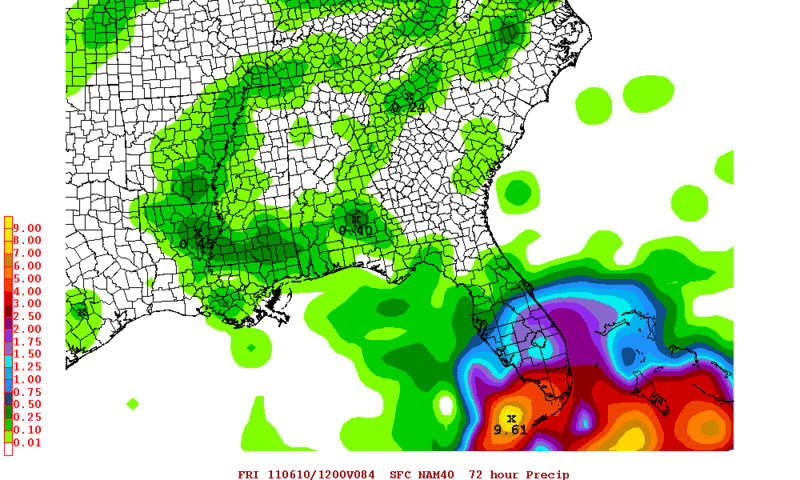
Some good rain for south florida as per the NAM.
0 likes
The following post is NOT an official forecast and should not be used as such. It is just the opinion of the poster and may or may not be backed by sound meteorological data. It is NOT endorsed by any professional institution including storm2k.org For Official Information please refer to the NHC and NWS products.
-
Scorpion
we're not getting anything now either. we hit a couple of mid latitude jackpots back in late March but have had little since then. in a normal summer pattern the west coast does do well in the thunderstorm category as the dominant east coast seabreeze collides with the gulf breeze on our side of the state and the resultant convection pushes westward. that pattern was in short supply last year...hopefully this year is better.
0 likes

btw Last year, we were swamped with rain in summer. August produced 22". No, I am not kidding. I measured it in my rain gauge that was dumped daily because it was so heavy. Keeping track of it was amazing. Then Sept it shut right off! The only thing you can rely on for summer rains is.........they are completely unreliable. 

0 likes
-
gatorcane

- S2K Supporter
- Posts: 23708
- Age: 48
- Joined: Sun Mar 13, 2005 3:54 pm
- Location: Boca Raton, FL
Funny snippet from NWS Miami tonight...all kidding aside, I have never seen it this dry in South Florida this late into the rainy season. It's crispy out there.
000
FXUS62 KMFL 090212
AFDMFL
AREA FORECAST DISCUSSION
NATIONAL WEATHER SERVICE MIAMI FL
1012 PM EDT WED JUN 8 2011
.UPDATE...WE FINALLY HAVE MORE SHOWER ACTIVITY OCCURRING!
OKAY...WON`T GET TOO EXCITED AS ACTIVITY IS ONLY ISOLATED
BUT...HEY...AT LEAST IT`S A START. FOR THE REST OF THE
NIGHT...MAINTAINED ISOLATED SHOWERS ALONG THE ATLANTIC COAST WITH
DRY CONDITIONS INTERIOR/GULF COAST. THE EVENING MIAMI SOUNDING
SHOWED PW AT 1.49 INCHES (FOR THE 3RD SOUNDING IN A ROW!) AND THIS
WILL BE ON A SLOW INCREASE OVER THE NEXT FEW DAYS...LEADING TO A
SLIGHT UP-TICK IN ACTIVITY. WIDESPREAD RAINS ARE NOT
EXPECTED...BUT AT LEAST THERE WILL BE SOME SHOWERS AND STORMS
AROUND. BUT GIVEN THE DROUGHT...CONCERN FOR LIGHTNING STRIKES
IGNITING NEW FIRES IS HIGH.
E "PRARIE".....
http://forecast.weather.gov/product.php ... glossary=1
0 likes

I sure hope last night's ECMWF run comes true, it brings in some of that Caribbean moisture over the FL Peninsula and leaves a weakness in atmosphere in its entire run. Hopefully that would be more than enough to get our afternoon & evening storms going. I am tired of waking up to the smokie smell in the air during the past few days.
http://www.meteo.psu.edu/~gadomski/ECMWF_0z/ecmwfloop.html
http://www.meteo.psu.edu/~gadomski/ECMWF_0z/ecmwfloop.html
0 likes
-
dolebot_Broward_NW
- Category 2

- Posts: 529
- Joined: Fri Sep 10, 2004 6:38 am
Re: Florida Weather Thread: Beginning of the rainy season?
The funny part is that the same office called 26 May the "official start" to the rainy season, despite sub 70's DP and no sign of rain. We still don't have enough moisture to support t-storms nearly 2 weeks later. That high over the SE needs to MOVE!
0 likes

-
thetruesms
- Professional-Met
- Posts: 844
- Age: 42
- Joined: Thu Aug 16, 2007 1:14 pm
- Location: Tallahasee, FL
- Contact:
Re:
That's actually the High Resolution Rapid Refresh, which is different from the RUC (though they fill the same niche).NDG wrote:11z RUC shows a nice surge of moisture to head over S FL today, showing scattered to widespread showers.
[img]http://rapidrefresh.noaa.gov/hrrrconus/from_jet/hrrr/t6/2011060911/cref_t6sfc_f08.png[img]
Also, while moisture does look to be increasing, the composite reflectivity isn't necessarily the best product to be looking for rainfall, particularly if it'll be light. For example, take a look at the corresponding accumulated rainfall graphic for the same time:

What I think is happening, is that what's showing up in the composite reflectivity graphic is fairly high up, and evaporating in the relative dry low-mid levels, which you can see in the wide spread between the temperature and dewpoint profiles here:

Even when you look at the max 1km reflectivity, you can see that what's closer to the ground is relatively limited

But, like the Miami AFD from last night said, "Hey . . . at least it's a start"
0 likes
Return to “USA & Caribbean Weather”
Who is online
Users browsing this forum: No registered users and 36 guests