
I think it was two years ago we had an SSW event, and basically nothing happened?
No doubt that there is some connection there, I'm just not positive that it will have an impact on us.
Texas Fall-2014
Moderator: S2k Moderators
Forum rules

The posts in this forum are NOT official forecast and should not be used as such. They are just the opinion of the poster and may or may not be backed by sound meteorological data. They are NOT endorsed by any professional institution or STORM2K.
0 likes
The above post and any post by dhweather is NOT an official forecast and should not be used as such. It is just the opinion of the poster and may or may not be backed by sound meteorological data. It is NOT endorsed by any professional institution including storm2k.org. For official information, please refer to NWS products.
I have been Lucy'd so much this year with rain, I'm trying not to get my hopes up, but it looks like we will get at least some rain in the coming week. Hopefully that tropical moisture surges in. Is it too much to ask to have PWAT's at 3" plus in November? 
0 likes
The above post and any post by dhweather is NOT an official forecast and should not be used as such. It is just the opinion of the poster and may or may not be backed by sound meteorological data. It is NOT endorsed by any professional institution including storm2k.org. For official information, please refer to NWS products.
-
somethingfunny

- ChatStaff

- Posts: 3926
- Age: 37
- Joined: Thu May 31, 2007 10:30 pm
- Location: McKinney, Texas
Re:
dhweather wrote:I have been Lucy'd so much this year with rain, I'm trying not to get my hopes up, but it looks like we will get at least some rain in the coming week. Hopefully that tropical moisture surges in. Is it too much to ask to have PWAT's at 3" plus in November?
Yes, that is probably too much to ask
Our best storms around here over the years tend to be the ones that look completely boring and average in the forecast.
0 likes
I am not a meteorologist, and any posts made by me are not official forecasts or to be interpreted as being intelligent. These posts are just my opinions and are probably silly opinions.
-
South Texas Storms

- Professional-Met

- Posts: 4258
- Joined: Thu Jun 24, 2010 12:28 am
- Location: Houston, TX
Re:
somethingfunny wrote:Hey guys, just be aware with this approaching front today... the SPC has the Metroplex in a Marginal Risk - storms are unlikely but if we get any they might be hailers. Then, Saturday morning might have some patches of freezing temperatures or frost around North Texas. It's unlikely but possible so if you live in one of those typical cold patches, might wanna be prepared to protect your plants. This is one of those cold fronts where the forecast seems to get colder every day that we get closer to it.
Yeah and the storm chances increase across central and southern Texas this evening. The high-res models are indicating a line of storms moving through the Hill Country tonight along the cold front.
0 likes

-
Ralph's Weather
- S2K Supporter

- Posts: 3371
- Age: 38
- Joined: Fri Dec 13, 2013 11:55 am
- Location: Lindale, TX
- Contact:
Re:
texas1836 wrote:Looking at things the way they are right now, there's a slight (and I mean slight) chance of a light frost Saturday morning. At least for McKinney, could be a reach, but you never know.
I would say there is a pretty good chance of frost at my family's ranch north of Lindale, but I bet it will be a bit warm and dry for it to be widespread. It will be a close call both Sat and Sun mornings with forecasted temps in the mid 30s.
0 likes
Follow on Facebook at Ralph's Weather.
-
aggiecutter
- Category 5

- Posts: 1755
- Joined: Thu Oct 14, 2004 9:22 pm
- Location: Texarkana
Re: Texas Fall-2014
Freeze forecast for Texarkana for Friday night:
Friday Night Mostly clear, with a low around 31. Northeast wind 5 to 10 mph
Friday Night Mostly clear, with a low around 31. Northeast wind 5 to 10 mph
0 likes

Euro weeklies and some longer range ENS looks interesting. Certainly raises an eyebrow.
0 likes
The above post and any post by Ntxw is NOT an official forecast and should not be used as such. It is just the opinion of the poster and may or may not be backed by sound meteorological data. It is NOT endorsed by any professional institution including Storm2k. For official information, please refer to NWS products.
Help support Storm2K!


-
Portastorm

- Storm2k Moderator

- Posts: 9955
- Age: 63
- Joined: Fri Jul 11, 2003 9:16 am
- Location: Round Rock, TX
- Contact:
The 0z GFS op run looks interesting. Next week for SC TX we see 2-3" of rain and temps holding in the 50s from Wednesday onward. That's no doubt due to the progged upper level low meandering around the state, shown by both the GFS and Euro. And then there's this huge cold front around mid month ... hmmm ... 
0 likes
Any forecasts under my name are to be taken with a grain of salt. Get your best forecasts from the National Weather Service and National Hurricane Center.
-
TheProfessor

- Professional-Met
- Posts: 3506
- Age: 29
- Joined: Tue Dec 03, 2013 10:56 am
- Location: Wichita, Kansas
Re: Texas Fall-2014
Freeze Warnings have been issued for the Northern Counties of the Metroplex.

0 likes
An alumnus of The Ohio State University.
Your local National Weather Service office is your best source for weather information.
Your local National Weather Service office is your best source for weather information.
Re: Re:
Big O wrote:Ntxw wrote:Euro weeklies and some longer range ENS looks interesting. Certainly raises an eyebrow.
Please elaborate.
All guidance amass a large cold dome in North-Central Canada. Likely a result of the stratospheric warming occuring. A deep low or ridge in NW NA could displace a chunk of it. The winter storm track is be laid down in front of our very eyes, bombogenesis is about to occur in the east coast this weekend and cut off low crossing the south central states (Texas/Oklahoma). Climo this time of year is for cyclogenesis to occur in the northern plains and crossing into Canada, that isn't happening.
Anyway this is a high confidence forecast for the NWS, pretty easy since everything is black and white.
FWD
.LONG TERM...
A TROUGH CONTINUES TO DEEPEN AS IT APPROACHES THE WEST COAST. IT
WILL SWING EAST THROUGH THE WESTERN STATES...PASSING THE CONTINENTAL
DIVIDE ON MONDAY. AT THAT POINT...SOUTHERLY FLOW WITHIN SEVERAL
THOUSAND FEET OF THE SURFACE WILL SURGE RICH GULF MOISTURE INTO
NORTH TEXAS...BENEATH DESTABILIZING SOUTHWEST FLOW ALOFT. PW VALUES
WILL SOAR ABOVE 1.5 INCHES. TRAINING ECHOES OF CONSIDERABLE
PRECIPITATION EFFICIENCY MAY PRECEDE A FRONTAL PASSAGE ON TUESDAY...
AFTER WHICH ELEVATED HEAVY RAIN MAY PERSIST. A CUT-OFF LOW IS NOW
THE CONSENSUS AMONG THE EXTENDED MODELS THOUGH THERE IS SOME
DISPARITY IN ITS PLACEMENT. BUT EVEN WITH THIS DISPARITY...THERE IS
REMARKABLY GOOD AGREEMENT FOR A CUT-OFF ON DAY 5-6...HENCE WE HAVE
SOME OF THE HIGHEST POPS YOU WILL EVER SEE THAT FAR OUT IN THE
FORECAST...INCLUDING 70-80 ON TUESDAY. POPS HAVE BEEN REDUCED FOR
THURSDAY...BUT DEPENDING ON THE EVENTUAL ANCHORING POINT OF THE
CUT-OFF...THE END OF THE RAIN EVENT MAY BE LATER IN THE WEEK.
0 likes
The above post and any post by Ntxw is NOT an official forecast and should not be used as such. It is just the opinion of the poster and may or may not be backed by sound meteorological data. It is NOT endorsed by any professional institution including Storm2k. For official information, please refer to NWS products.
Help support Storm2K!
Help support Storm2K!
-
srainhoutx

- S2K Supporter
- Posts: 6919
- Age: 68
- Joined: Sun Jan 14, 2007 11:34 am
- Location: Haywood County, NC
- Contact:
Re: Texas Fall-2014
Morning Briefing form Jeff:
Strong cold front moving into SE TX and will result in the coldest weather since last spring this weekend.
Increasing confidence in significant and potentially prolonged heavy rainfall event next week.
Cold front is crossing SE TX currently and winds will pick up out of the north a few hours past sunrise this morning. Batch of thunderstorms ahead of the boundary is moving southward across south TX after brushing our western counties overnight. Cold air advection will onset by mid-morning, but will be offset some by the sunny skies. Think temperatures will warm into the low to mid 70’s and then begin to fall by late afternoon. Models continue to trend colder and colder with this air mass and this will require some modification to the temperatures for the weekend and this evening.
Other item of marginal concern this afternoon is fire weather. Gusty N winds of 15-25mph and incoming dry air mass with dewpoints falling into the 30’s and RH values into the 20’s suggest a modest fire weather concern. The past few weeks have been very dry and surface fine fuels have dried as noted in the increased KBDI values. Main threat would be quick moving grass fires mainly in the counties southwest of Houston (Fort Bend, Wharton, Jackson, Matagorda, Brazoria, and Colorado). Current data does not suggest Red Flag Warning conditions will be met this afternoon.
This evening:
Will undercut temperatures by 5 degrees for this evening over yesterday as the temperature fall once the sun sets will likely be a little more rapid. Temperatures at 600pm will be near 70 falling to the upper 50’s by 800pm and the mid 50’s by 1000pm with north winds of 5-10mph.
Weekend:
Will lower morning lows on Saturday into the lower 40’s north of I-10 as guidance has trended colder showing a low of 40 at College Station and 44 at IAH. Weak cold air advection continues on Saturday so temperatures will only top out in the mid to upper 60’s for highs. Even colder on Sunday morning with lows into the upper 30’s around Lake Livingston to near 40 Houston metro and mid 50’s on the coast. Some of the usually cold locations could even dip into the mid 30’s. GFS is showing 33 at Conroe Sunday morning. Do not think any widespread freeze is likely even for our northern counties, but a few locations could have near freezing temperatures and frost especially in low lying areas and river bottoms where the dense cold air will settle during the night.
Next Week:
Major upper air pattern change will result in an extended period of wet weather. A strong upper level trough will drop into the SW US and dig into northern MX early next week which will result in strong return flow and moisture advection off the Gulf of Mexico starting late Sunday. Global models remain inconsistent on their handling of how this trough will evolve and when exactly it progresses across TX. The overnight guidance as trended away from the more progressive solutions being offered yesterday and support a slower and more cut off upper level system which would only serve to prolong what is an already very wet forecast. Will start to lean more toward the slower solution with a stalling cold front reaching into the state on Tuesday and our area Wednesday. As the trough digs into the Baja and northern MX region it will capture then Hurricane Vance off the southwest coast of Mexico and recurve it NNE and NE into the Mexican coast and then bring the remaining moisture across TX. Hurricane track guidance is in fair agreement on this pattern and the latest NHC forecast brings Vance to the Mexican coast late Tuesday evening.
Ahead of the upper trough excessive moisture pouring of the top of Vance and increasing Gulf moisture will saturate the air column. The flow aloft will turn increasingly out of the SW on the downstream side of the upper trough and begin to parallel the frontal boundary resulting in it stalling. Numerous disturbances ejecting out of the trough and Vance will move along the stalling front and produce periods of very heavy training rainfall.
Expect heavy convective rains to begins across N TX on Tuesday and begin to sag southward into central and SE TX Tuesday afternoon and Wednesday. Remains of Vance should arrive over top of the region Wednesday and Thursday helping to prolong the heavy rainfall threat. In fact some of the latest guidance hangs on to heavy rainfall into next weekend. PWS values are forecasted to near or exceed 2.0 inches starting late Tuesday and with slowing convection and high potential for cell training excessive rainfall and flooding is becoming a concern. Big question is exactly what happens to the upper trough to our SW and does it cut off and continue the Pacific “El Nino” enhanced tap of moisture through the end of the week as this will be the ultimate determining factor in the duration of the rainfall and the overall totals.
Widespread rainfall amounts of 1-3 inches appears likely for the event, but I strongly caution that these totals may be significantly under forecasted at the moment, but given the onset is still over 4 days away I would not go much higher than that at this time. For what it is worth this is a historical flood setup in the state of TX and in the past similar setups with a stalling frontal boundary, deep upper trough SW of TX, and the remains of an eastern Pacific hurricane have produced devastating flooding in October 1994, October 1998, October 2002, and October 2006.
Vance: Model Track Guidance:
0 likes
Carla/Alicia/Jerry(In The Eye)/Michelle/Charley/Ivan/Dennis/Katrina/Rita/Wilma/Ike/Harvey
Member: National Weather Association
Wx Infinity Forums
http://wxinfinity.com/index.php
Facebook.com/WeatherInfinity
Twitter @WeatherInfinity
Member: National Weather Association
Wx Infinity Forums
http://wxinfinity.com/index.php
Facebook.com/WeatherInfinity
Twitter @WeatherInfinity
-
Portastorm
- Storm2k Moderator
- Posts: 9955
- Age: 63
- Joined: Fri Jul 11, 2003 9:16 am
- Location: Round Rock, TX
- Contact:
Re: Texas Fall-2014
As srainhoutx and I have been talking about this morning ... let's pay attention to the synoptics over the next few weeks. Watch how the weather systems evolve and move through Texas. It's going to give you a good clue on what to expect this coming winter.
0 likes
Any forecasts under my name are to be taken with a grain of salt. Get your best forecasts from the National Weather Service and National Hurricane Center.
-
weatherdude1108
- Category 5
- Posts: 4228
- Joined: Tue Dec 13, 2011 1:04 pm
- Location: Northwest Austin/Cedar Park, TX
-
South Texas Storms
- Professional-Met
- Posts: 4258
- Joined: Thu Jun 24, 2010 12:28 am
- Location: Houston, TX
Re: Texas Fall-2014
My house in SA got 1.7 inches of rain last night! I'm very happy and thankful! 
0 likes
-
srainhoutx
- S2K Supporter
- Posts: 6919
- Age: 68
- Joined: Sun Jan 14, 2007 11:34 am
- Location: Haywood County, NC
- Contact:
Re: Texas Fall-2014
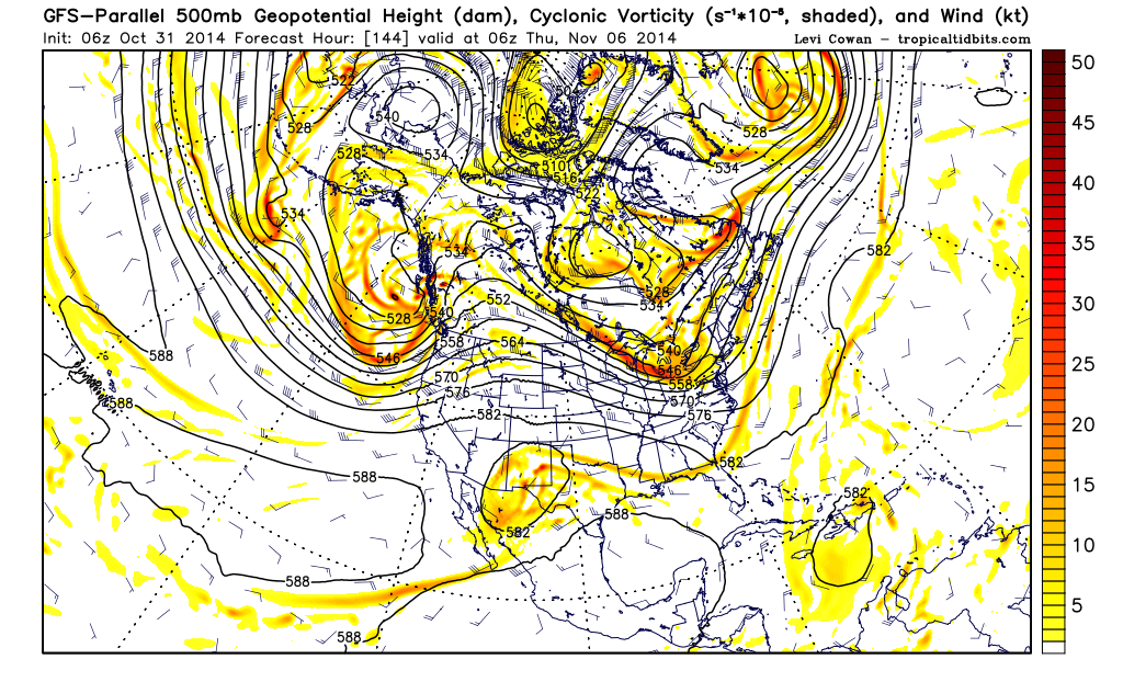
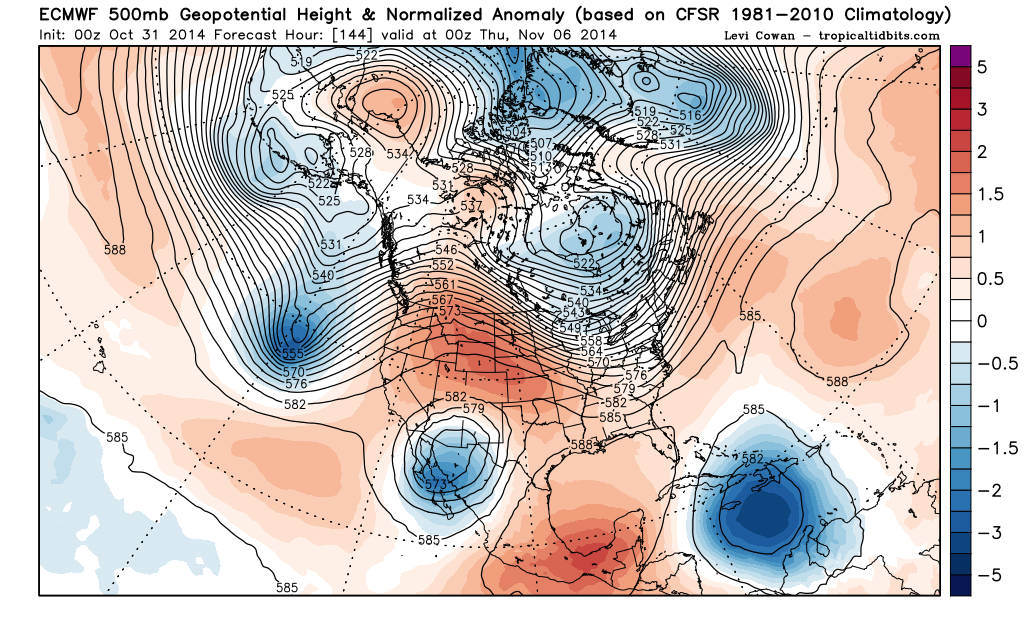
As Jeff mentioned in his morning briefing, next week offers a real forecasting challenge and certainly a pattern we typically see with an El Nino developing. There remain some slight disagreement with the placing of the cut off 500mb Upper Low to our W, but the Parallel GFS that will go online soon is not all that different than the European computer model. During Fall/Winter we typically see these cut off lows develop in the SW with a stalled boundary across Texas and the Southern Plains. There is a good long fetch of Pacific moisture that will only be enhanced by Vance and its remnants across Mexico on ENE into the Southern Plains and the Mid Mississippi Valley. The computer models continue to advertise a Coastal surface low developing along the S Texas Coast near Corpus Christi next Wednesday. Should a Coastal low develop, rainfall amounts would likely need to be increased rather dramatically across all of our Region. It could be rather raw temperature wise with temperatures in the upper 50's and heavy convective rains most of next week.
0 likes
Carla/Alicia/Jerry(In The Eye)/Michelle/Charley/Ivan/Dennis/Katrina/Rita/Wilma/Ike/Harvey
Member: National Weather Association
Wx Infinity Forums
http://wxinfinity.com/index.php
Facebook.com/WeatherInfinity
Twitter @WeatherInfinity
Member: National Weather Association
Wx Infinity Forums
http://wxinfinity.com/index.php
Facebook.com/WeatherInfinity
Twitter @WeatherInfinity
-
TheProfessor
- Professional-Met
- Posts: 3506
- Age: 29
- Joined: Tue Dec 03, 2013 10:56 am
- Location: Wichita, Kansas
Return to “USA & Caribbean Weather”
Who is online
Users browsing this forum: CaptinCrunch and 40 guests