Texas Summer 2017

U.S. & Caribbean Weather Discussions and Severe Weather Events

Moderator: S2k Moderators

Forum rules

The posts in this forum are NOT official forecast and should not be used as such. They are just the opinion of the poster and may or may not be backed by sound meteorological data. They are NOT endorsed by any professional institution or STORM2K.

Help Support Storm2K
Message
Author
gpsnowman
S2K Supporter
S2K Supporter
Posts: 3186
Joined: Fri Jan 07, 2011 10:35 am
Location: Grand Prairie Tx

Re: Texas Summer 2017

#741 Postby gpsnowman » Sat Jul 22, 2017 3:47 pm

Texas Snowman wrote:From Steve McCauley's Facebook page: :D

"Well, I think I have officially gone overboard now, but I care not; palm trees make me happy. I will eat next month.

And now that we have the hottest days ahead of us, I am in hopes that they can withstand the heat and prepare themselves for the coming cold this winter. It is with a little trepidation that I report that the same data analysis done last May that predicted a wet first half to our summer is also predicting early and perhaps SEVERE cold snaps in December.

I look forward to the challenge!"

Hello 1983!! Texas Snowman, that put a smile on my face. In Steve we trust. :froze:
0 likes   

Brent
S2K Supporter
S2K Supporter
Posts: 38091
Age: 36
Joined: Sun May 16, 2004 10:30 pm
Location: Tulsa Oklahoma
Contact:

Re: Texas Summer 2017

#742 Postby Brent » Sat Jul 22, 2017 4:00 pm

Texas Snowman wrote:From Steve McCauley's Facebook page: :D

"Well, I think I have officially gone overboard now, but I care not; palm trees make me happy. I will eat next month.

And now that we have the hottest days ahead of us, I am in hopes that they can withstand the heat and prepare themselves for the coming cold this winter. It is with a little trepidation that I report that the same data analysis done last May that predicted a wet first half to our summer is also predicting early and perhaps SEVERE cold snaps in December.

I look forward to the challenge!"


Bring it on! :cold:
0 likes   
#neversummer

User avatar
Ntxw
Storm2k Moderator
Storm2k Moderator
Posts: 22786
Joined: Wed Oct 21, 2009 6:34 pm
Location: DFW, Texas

Re: Texas Summer 2017

#743 Postby Ntxw » Sat Jul 22, 2017 4:44 pm

DFW hit 101, high for the summer so far today. Also marks 5th 100+ and 3rd consecutive day.
0 likes   
The above post and any post by Ntxw is NOT an official forecast and should not be used as such. It is just the opinion of the poster and may or may not be backed by sound meteorological data. It is NOT endorsed by any professional institution including Storm2k. For official information, please refer to NWS products.

  Help support Storm2K!
Help Support Storm2K

aggiecutter
Category 5
Category 5
Posts: 1753
Joined: Thu Oct 14, 2004 9:22 pm
Location: Texarkana

Re: Texas Summer 2017

#744 Postby aggiecutter » Sat Jul 22, 2017 5:19 pm

Ntxw wrote:DFW hit 101, high for the summer so far today. Also marks 5th 100+ and 3rd consecutive day.


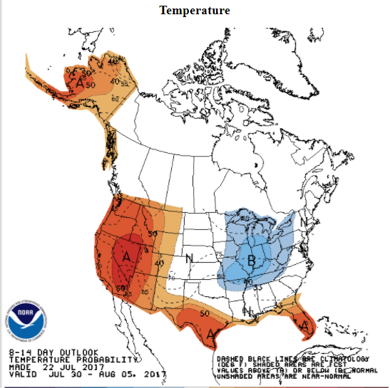
Texarkana still has yet to see a temperature above 95 for the summer. Looks like relief is on the way for parts of Texas:

Image
0 likes   

Brent
S2K Supporter
S2K Supporter
Posts: 38091
Age: 36
Joined: Sun May 16, 2004 10:30 pm
Location: Tulsa Oklahoma
Contact:

Re: Texas Summer 2017

#745 Postby Brent » Sat Jul 22, 2017 10:27 pm

Looks to be something resembling a front next Saturday... perhaps the 100's won't go on forever? NBC 5 has back into the 90s again by Sunday.

Euro has rain Saturday now...

GFS/CMC also show at least a front and temps closer to normal(which is still hot but nothing worse than it has been). The heat peaks Thu/Fri if that occurs.
0 likes   
#neversummer

User avatar
Ntxw
Storm2k Moderator
Storm2k Moderator
Posts: 22786
Joined: Wed Oct 21, 2009 6:34 pm
Location: DFW, Texas

Re: Texas Summer 2017

#746 Postby Ntxw » Sun Jul 23, 2017 7:18 am

End of the Euro run has anomalous cooler air for August as the ridge goes west and NW flow. Lets see if it is a start of a trend
3 likes   
The above post and any post by Ntxw is NOT an official forecast and should not be used as such. It is just the opinion of the poster and may or may not be backed by sound meteorological data. It is NOT endorsed by any professional institution including Storm2k. For official information, please refer to NWS products.


  Help support Storm2K!

Help Support Storm2K


User avatar
bubba hotep
S2K Supporter
S2K Supporter
Posts: 5837
Joined: Wed Dec 28, 2016 1:00 am
Location: Collin County Texas

Re: Texas Summer 2017

#747 Postby bubba hotep » Sun Jul 23, 2017 11:34 am

Ntxw wrote:End of the Euro run has anomalous cooler air for August as the ridge goes west and NW flow. Lets see if it is a start of a trend


Signs of that have been showing up in the longer range for a few days, 06z GFS trended that way. Next Friday could be the end of the current "heat wave" but the Pacific getting active can throw the models out of wack.
1 likes   
Winter time post are almost exclusively focused on the DFW area.

User avatar
bubba hotep
S2K Supporter
S2K Supporter
Posts: 5837
Joined: Wed Dec 28, 2016 1:00 am
Location: Collin County Texas

Re: Texas Summer 2017

#748 Postby bubba hotep » Sun Jul 23, 2017 11:35 am

SPC shifts things south a bit to capture N. Texas #WooStorms!

Image
1 likes   
Winter time post are almost exclusively focused on the DFW area.

weatherdude1108
Category 5
Category 5
Posts: 4228
Joined: Tue Dec 13, 2011 1:04 pm
Location: Northwest Austin/Cedar Park, TX

Re: Texas Summer 2017

#749 Postby weatherdude1108 » Sun Jul 23, 2017 2:34 pm

RAINING NICELY HERE with thunder. Dark with loud kaboombs! Lightning within 100 yards I think! :eek:
Was 101 degrees an hout ago. Now 86. :D A cell is developing right on top of us. LOVE IT!!

This applies to my area:

Special Weather Statement
National Weather Service Austin/San Antonio TX
301 PM CDT SUN JUL 23 2017

TXZ173-192-232030-
Williamson TX-Travis TX-
301 PM CDT SUN JUL 23 2017

...SIGNIFICANT WEATHER ADVISORY FOR SOUTHWESTERN WILLIAMSON AND
NORTHWESTERN TRAVIS COUNTIES UNTIL 330 PM CDT...

At 300 PM CDT, Doppler radar was tracking a strong thunderstorm over
Cedar Park, moving southwest at 15 mph.

Pea size hail and winds in excess of 40 mph will be possible with
this storm.

Locations impacted include...
Austin, Cedar Park, Anderson Mill, Leander, Lakeway, Lago Vista, West
Lake Hills, Hudson Bend, Mansfield Dam, Jonestown, Briarcliff, Brushy
Creek, Jollyville and Lost Creek.

PRECAUTIONARY/PREPAREDNESS ACTIONS...

Frequent cloud to ground lightning is occurring with this storm.
Lightning can strike 10 miles away from a thunderstorm. Seek a safe
shelter inside a building or vehicle.
3 likes   
The preceding post is NOT an official forecast, and should not be used as such. It is only the opinion of the poster and may or may not be backed by sound meteorological data. It is NOT endorsed by any professional institution including storm2k.org. For Official Information please refer to the NHC and NWS products.

weatherdude1108
Category 5
Category 5
Posts: 4228
Joined: Tue Dec 13, 2011 1:04 pm
Location: Northwest Austin/Cedar Park, TX

Re: Texas Summer 2017

#750 Postby weatherdude1108 » Sun Jul 23, 2017 3:50 pm

0.65 here at the Weatherdude Center. 79 degrees at 3:30pm in July. Nice change over the past...MONTH. :D
1 likes   
The preceding post is NOT an official forecast, and should not be used as such. It is only the opinion of the poster and may or may not be backed by sound meteorological data. It is NOT endorsed by any professional institution including storm2k.org. For Official Information please refer to the NHC and NWS products.

gpsnowman
S2K Supporter
S2K Supporter
Posts: 3186
Joined: Fri Jan 07, 2011 10:35 am
Location: Grand Prairie Tx

Re: Texas Summer 2017

#751 Postby gpsnowman » Sun Jul 23, 2017 4:01 pm

Nice storm in Irving right now, heavy rain with some thunder. It appears to be coming to an end though. Kind of just popped up out of nowhere.
0 likes   

User avatar
bubba hotep
S2K Supporter
S2K Supporter
Posts: 5837
Joined: Wed Dec 28, 2016 1:00 am
Location: Collin County Texas

Re: Texas Summer 2017

#752 Postby bubba hotep » Sun Jul 23, 2017 5:50 pm

Wss holding out hope for a storm today but just blazing hot!
0 likes   
Winter time post are almost exclusively focused on the DFW area.

User avatar
Ntxw
Storm2k Moderator
Storm2k Moderator
Posts: 22786
Joined: Wed Oct 21, 2009 6:34 pm
Location: DFW, Texas

Re: Texas Summer 2017

#753 Postby Ntxw » Sun Jul 23, 2017 5:59 pm

That outflow from the Irving storm helped nudged DFW down a few degrees but not before another high of 101 today.
0 likes   
The above post and any post by Ntxw is NOT an official forecast and should not be used as such. It is just the opinion of the poster and may or may not be backed by sound meteorological data. It is NOT endorsed by any professional institution including Storm2k. For official information, please refer to NWS products.


  Help support Storm2K!

Help Support Storm2K


User avatar
bubba hotep
S2K Supporter
S2K Supporter
Posts: 5837
Joined: Wed Dec 28, 2016 1:00 am
Location: Collin County Texas

Re: Texas Summer 2017

#754 Postby bubba hotep » Sun Jul 23, 2017 8:33 pm

bubba hotep wrote:Wss holding out hope for a storm today but just blazing hot!


Maybe it pays off for once?

Image
0 likes   
Winter time post are almost exclusively focused on the DFW area.

User avatar
Texas Snowman
Storm2k Moderator
Storm2k Moderator
Posts: 6179
Joined: Fri Jan 25, 2008 11:29 am
Location: Denison, Texas

Re: Texas Summer 2017

#755 Postby Texas Snowman » Sun Jul 23, 2017 8:34 pm

730
WUUS54 KFWD 240117
SVRFWD
TXC147-181-277-240215-
/O.NEW.KFWD.SV.W.0300.170724T0117Z-170724T0215Z/

BULLETIN - IMMEDIATE BROADCAST REQUESTED
Severe Thunderstorm Warning
National Weather Service Fort Worth TX
817 PM CDT SUN JUL 23 2017

The National Weather Service in Fort Worth has issued a

* Severe Thunderstorm Warning for...
Lamar County in north central Texas...
Southeastern Grayson County in north central Texas...
Fannin County in north central Texas...

* Until 915 PM CDT.

* At 816 PM CDT, severe thunderstorms were located along a line
extending from near Raymond Gary State Park to near Dorchester,
moving south at 40 mph.

HAZARD...60 mph wind gusts and hail to penny size.

SOURCE...Radar indicated.

IMPACT...Expect damage to roofs, siding, and trees.

* Locations impacted include...
Sherman, Paris, Bonham, Van Alstyne, Howe, Leonard, Honey Grove,
Whitewright, Gunter, Blossom, Bells, Tom Bean, Savoy, Ector,
Deport, Dodd City, Bailey, Knollwood, Ravenna and Dorchester.

PRECAUTIONARY/PREPAREDNESS ACTIONS...

For your protection get inside a sturdy structure and stay away from
windows.

If on or near Lake Texoma, Lake Bonham, or Lake Pat Mayse, get away
from the water and move indoors or inside a vehicle. Do not be
caught on the water in a thunderstorm. High winds and waves can
capsize boats.

Heavy rainfall is occurring with these storms, and may lead to
flooding creeks and typical low-lying areas. Do not drive your
vehicle through flooded roadways.

&&

LAT...LON 3393 9556 3388 9554 3389 9532 3338 9531
3348 9556 3350 9576 3346 9586 3341 9586
3334 9639 3340 9639 3341 9679 3364 9681
3375 9641 3369 9634 3376 9624 3376 9619
3380 9616 3381 9617 3384 9577 3394 9560
TIME...MOT...LOC 0116Z 350DEG 34KT 3401 9519 3360 9672

HAIL...0.75IN
WIND...60MPH

$$
0 likes   
The above post and any post by Texas Snowman is NOT an official forecast and should not be used as such. It is just the opinion of the poster and may or may not be backed by sound meteorological data. It is NOT endorsed by any professional institution including storm2k.org. For official information, please refer to NWS products.

User avatar
Texas Snowman
Storm2k Moderator
Storm2k Moderator
Posts: 6179
Joined: Fri Jan 25, 2008 11:29 am
Location: Denison, Texas

Re: Texas Summer 2017

#756 Postby Texas Snowman » Sun Jul 23, 2017 8:35 pm

:uarrow: Those storms split, missed my house! Gully washers five to 10 miles either side of my backyard.
0 likes   
The above post and any post by Texas Snowman is NOT an official forecast and should not be used as such. It is just the opinion of the poster and may or may not be backed by sound meteorological data. It is NOT endorsed by any professional institution including storm2k.org. For official information, please refer to NWS products.

User avatar
bubba hotep
S2K Supporter
S2K Supporter
Posts: 5837
Joined: Wed Dec 28, 2016 1:00 am
Location: Collin County Texas

Re: Texas Summer 2017

#757 Postby bubba hotep » Sun Jul 23, 2017 9:07 pm

Storms have spit out a hefty outflow... hopefully they don't collapse and then the boundary sets off storms south of us...

Image
0 likes   
Winter time post are almost exclusively focused on the DFW area.

User avatar
Texas Snowman
Storm2k Moderator
Storm2k Moderator
Posts: 6179
Joined: Fri Jan 25, 2008 11:29 am
Location: Denison, Texas

Re: Texas Summer 2017

#758 Postby Texas Snowman » Sun Jul 23, 2017 9:14 pm

Storms back developed, got some nice rain on the yard!

But NOTHING like the 1.56 inches at North Texas Regional Airport to my west.

In less than an hour!
0 likes   
The above post and any post by Texas Snowman is NOT an official forecast and should not be used as such. It is just the opinion of the poster and may or may not be backed by sound meteorological data. It is NOT endorsed by any professional institution including storm2k.org. For official information, please refer to NWS products.

Brent
S2K Supporter
S2K Supporter
Posts: 38091
Age: 36
Joined: Sun May 16, 2004 10:30 pm
Location: Tulsa Oklahoma
Contact:

Re: Texas Summer 2017

#759 Postby Brent » Sun Jul 23, 2017 9:26 pm

Come on rain :rain:
1 likes   
#neversummer

User avatar
Texas Snowman
Storm2k Moderator
Storm2k Moderator
Posts: 6179
Joined: Fri Jan 25, 2008 11:29 am
Location: Denison, Texas

Re: Texas Summer 2017

#760 Postby Texas Snowman » Sun Jul 23, 2017 9:31 pm

Sure don't see this very often in late July!!! :eek:

-----


Flood Advisory
National Weather Service Fort Worth TX
918 PM CDT SUN JUL 23 2017

TXC147-181-240515-
/O.NEW.KFWD.FA.Y.0161.170724T0218Z-170724T0515Z/
/00000.N.ER.000000T0000Z.000000T0000Z.000000T0000Z.OO/
Grayson TX-Fannin TX-
918 PM CDT SUN JUL 23 2017

The National Weather Service in Fort Worth has issued a

* Flood Advisory for Minor Flooding in Poor Drainage Areas for...
Grayson County in north central Texas...
Fannin County in north central Texas...

* Until 1215 AM CDT.

* At 916 PM CDT, Doppler radar and rain gauges indicated
thunderstorms continued to produce heavy rainfall across western
Grayson and eastern Fannin Counties. Automated rain gauges in the
area have already reported around 2 inches or rain. Excessive
runoff from these thunderstorms will cause minor flooding. Areas
that are low lying or usually experience poor drainage are most
likely to experience flooding. An additional one to two inches of
rain are possible in the next 3 hours.

* Some locations that will experience flooding include...
Sherman, Denison, Bonham, Van Alstyne, Howe, Pottsboro, Leonard,
Whitewright, Gunter, Bells, Tom Bean, Savoy, Ector, Dodd City,
Bailey, Knollwood, Ravenna, Dorchester, Bonham State Park and
Eisenhower State Park.

PRECAUTIONARY/PREPAREDNESS ACTIONS...

Turn around, don`t drown when encountering flooded roads. Most flood
deaths occur in vehicles.

Be especially cautious at night when it is harder to recognize the
dangers of flooding.

&&

LAT...LON 3389 9660 3384 9662 3382 9653 3377 9650
3378 9643 3369 9635 3370 9632 3377 9629
3375 9619 3384 9615 3384 9606 3341 9586
3334 9637 3340 9639 3340 9676 3387 9684
3386 9679 3382 9675 3384 9669 3392 9666

$$
1 likes   
The above post and any post by Texas Snowman is NOT an official forecast and should not be used as such. It is just the opinion of the poster and may or may not be backed by sound meteorological data. It is NOT endorsed by any professional institution including storm2k.org. For official information, please refer to NWS products.


Return to “USA & Caribbean Weather”

Who is online

Users browsing this forum: No registered users and 17 guests