Texas Summer 2022
Moderator: S2k Moderators
Forum rules

The posts in this forum are NOT official forecast and should not be used as such. They are just the opinion of the poster and may or may not be backed by sound meteorological data. They are NOT endorsed by any professional institution or STORM2K.
-
bubba hotep

- S2K Supporter

- Posts: 6014
- Joined: Wed Dec 28, 2016 1:00 am
- Location: Collin County Texas
-
South Texas Storms

- Professional-Met

- Posts: 4259
- Joined: Thu Jun 24, 2010 12:28 am
- Location: Houston, TX
Re: Texas Summer 2022
Past few runs of the Euro are showing a much needed pattern change for the Southern Plains in a little over a week with a weakness developing between ridges on the East and West Coast. Other models aren't as bullish. Hope the Euro can score on this one.
2 likes
-
bubba hotep
- S2K Supporter
- Posts: 6014
- Joined: Wed Dec 28, 2016 1:00 am
- Location: Collin County Texas
Re: Texas Summer 2022
South Texas Storms wrote:Past few runs of the Euro are showing a much needed pattern change for the Southern Plains in a little over a week with a weakness developing between ridges on the East and West Coast. Other models aren't as bullish. Hope the Euro can score on this one.
King EURO, is that you?

1 likes
Winter time post are almost exclusively focused on the DFW area.
-
Brent
- S2K Supporter
- Posts: 38755
- Age: 37
- Joined: Sun May 16, 2004 10:30 pm
- Location: Tulsa Oklahoma
- Contact:
Re: Texas Summer 2022
Most rain in weeks I've seen on radar here. Hopefully a sign of things to come
2 likes
#neversummer


Re: Texas Summer 2022
Portland, OR is forecasted to be 100s down the road and Seattle into the 90s. This is joy for Texas! Inverse correlation.
7 likes
The above post and any post by Ntxw is NOT an official forecast and should not be used as such. It is just the opinion of the poster and may or may not be backed by sound meteorological data. It is NOT endorsed by any professional institution including Storm2k. For official information, please refer to NWS products.
Help support Storm2K!
Re: Texas Summer 2022
Ntxw wrote:Portland, OR is forecasted to be 100s down the road and Seattle into the 90s. This is joy for Texas! Inverse correlation.
Just like last year when the Pacific Northwest was baking and we were not so hot. I agree with this scenario.
3 likes
-
Iceresistance

- Category 5

- Posts: 9592
- Age: 22
- Joined: Sat Oct 10, 2020 9:45 am
- Location: Tecumseh, OK/Norman, OK
Re: Texas Summer 2022
Brent wrote:Most rain in weeks I've seen on radar here. Hopefully a sign of things to come
Your area got clobbered with a severe thunderstorm earlier, the storms tried to get here but the drought ate it up.
1 likes
Bill 2015 & Beta 2020
Winter 2020-2021
All observations are in Tecumseh, OK unless otherwise noted.
Winter posts are focused mainly for Oklahoma & Texas.
Take any of my forecasts with a grain of salt, refer to the NWS, SPC, and NHC for official information
Never say Never with weather! Because ANYTHING is possible!
Winter 2020-2021
All observations are in Tecumseh, OK unless otherwise noted.
Winter posts are focused mainly for Oklahoma & Texas.
Take any of my forecasts with a grain of salt, refer to the NWS, SPC, and NHC for official information
Never say Never with weather! Because ANYTHING is possible!
-
Iceresistance
- Category 5
- Posts: 9592
- Age: 22
- Joined: Sat Oct 10, 2020 9:45 am
- Location: Tecumseh, OK/Norman, OK
Re: Texas Summer 2022
bubba hotep wrote:South Texas Storms wrote:Past few runs of the Euro are showing a much needed pattern change for the Southern Plains in a little over a week with a weakness developing between ridges on the East and West Coast. Other models aren't as bullish. Hope the Euro can score on this one.
King EURO, is that you?
https://m1o.pivotalweather.com/maps/models/ecmwf_full/2022072112/240/qpf_acc.us_sc.png
Come on Euro! You can do this! You are our only hope! We're counting on you!
0 likes
Bill 2015 & Beta 2020
Winter 2020-2021
All observations are in Tecumseh, OK unless otherwise noted.
Winter posts are focused mainly for Oklahoma & Texas.
Take any of my forecasts with a grain of salt, refer to the NWS, SPC, and NHC for official information
Never say Never with weather! Because ANYTHING is possible!
Winter 2020-2021
All observations are in Tecumseh, OK unless otherwise noted.
Winter posts are focused mainly for Oklahoma & Texas.
Take any of my forecasts with a grain of salt, refer to the NWS, SPC, and NHC for official information
Never say Never with weather! Because ANYTHING is possible!
-
Brent
- S2K Supporter
- Posts: 38755
- Age: 37
- Joined: Sun May 16, 2004 10:30 pm
- Location: Tulsa Oklahoma
- Contact:
Re: Texas Summer 2022
Iceresistance wrote:Brent wrote:Most rain in weeks I've seen on radar here. Hopefully a sign of things to come
Your area got clobbered with a severe thunderstorm earlier, the storms tried to get here but the drought ate it up.
I'm on the other side of the city from the severe but still had a legit rain. Even just now driving home it rained the entire way. A much different night than the previous where the sun was still in your eyes
0 likes
#neversummer
-
BrokenGlassRepublicn
- Category 1

- Posts: 483
- Joined: Sun Nov 20, 2011 8:07 pm
- Location: Richardson, Texas
Re: Texas Summer 2022
bubba hotep wrote:South Texas Storms wrote:Past few runs of the Euro are showing a much needed pattern change for the Southern Plains in a little over a week with a weakness developing between ridges on the East and West Coast. Other models aren't as bullish. Hope the Euro can score on this one.
King EURO, is that you?
https://m1o.pivotalweather.com/maps/models/ecmwf_full/2022072112/240/qpf_acc.us_sc.png
It don't matter who's in Austin, Euro is still the king.
0 likes
-
jasons2k

- Storm2k Executive

- Posts: 8290
- Age: 52
- Joined: Wed Jul 06, 2005 12:32 pm
- Location: The Woodlands, TX
Re: Texas Summer 2022
Morning update from Jeff:
For the first time this week there are no heat related warnings or advisories for the area.
Upper level ridge of high pressure currently located over the SW US will back westward slightly today and weaken on the eastern flank. This will allow a trough over the southern US to move westward a bit. Local radars over LA this morning show a complex of thunderstorms east of the central LA area moving westward and convection allowing models (CAMs) are in general agreement that this complex and its associated outflow boundary will continue westward toward the Sabine River today and then into east Texas this afternoon and toward the I-45 corridor by mid to late afternoon. With the subsidence from the ridge weakening over the area and moisture increasing from the east, expect the complex of storms or new storms to form along the leading westward moving outflow boundary. Best chances of rainfall will be east of I-45, although CAMs are suggesting areas of northern Harris, Liberty, San Jacinto, Walker, and Montgomery Counties may see the best chances this afternoon. Rainfall will be scattered and mainly focused east of I-45, so while there is about a 30% chance this afternoon, not everyone will see rain.
Ridge starts to shift back eastward this weekend, but still think there will be a chance for scattered showers and thunderstorms on Saturday with the seabreeze front and continued decent moisture levels before subsidence overruns the region again by Sunday. Ridge looks to never fully gain a foot hold over SE TX compared to the recent weeks and is based more north of the area so temperatures into next week look more like the mid to upper 90’s with 100’s over the Brazos Valley instead of the widespread 100’s of late. Additionally with the ridge axis just enough to the north this will open the door for westward moving tropical waves to move into the TX coast. The first should arrive around Tue/Wed with increased rain chances followed by another around next Friday. This slight pattern shift may be able to bring some drought and heat relief to the region.
Fire Weather:
Afternoon humidity values have not been mixing out as much as earlier this week and winds have returned to a more typical summer pattern of mainly light southerly and this has helped to reduce the critical fire weather concerns from earlier in the week. Fuel loads are extremely dry through the entire column and will remain dry until widespread wetting rains occur.
There is some concern this afternoon that storms in the are could producing lightning starts and may not produce rainfall over any new starts. Additionally, outflow winds of 40-50mph could quickly fan any new starts. Generally these would be short lived conditions, but similar activity and conditions in N TX earlier this week produced several wildfires due to lightning followed by little or no rainfall at the ignition site.
Jeff Lindner
0 likes
Re: Texas Summer 2022
DFW is actually still on pace to beat or tie 1980's monthly average as the hottest July. We saw another record low (6th record in a row, 16 80F or higher so far this month) that's keeping up the averages. The pattern relief may or may not keep us below 100 consistently, it would need to in order not to catch 1980. 91.7F currently is #2 with the record being 92F.
0 likes
The above post and any post by Ntxw is NOT an official forecast and should not be used as such. It is just the opinion of the poster and may or may not be backed by sound meteorological data. It is NOT endorsed by any professional institution including Storm2k. For official information, please refer to NWS products.
Help support Storm2K!
Help support Storm2K!
-
Iceresistance
- Category 5
- Posts: 9592
- Age: 22
- Joined: Sat Oct 10, 2020 9:45 am
- Location: Tecumseh, OK/Norman, OK
Re: Texas Summer 2022
KFOR has highs in the mid 80s next weekend with a lot of rain
1 likes
Bill 2015 & Beta 2020
Winter 2020-2021
All observations are in Tecumseh, OK unless otherwise noted.
Winter posts are focused mainly for Oklahoma & Texas.
Take any of my forecasts with a grain of salt, refer to the NWS, SPC, and NHC for official information
Never say Never with weather! Because ANYTHING is possible!
Winter 2020-2021
All observations are in Tecumseh, OK unless otherwise noted.
Winter posts are focused mainly for Oklahoma & Texas.
Take any of my forecasts with a grain of salt, refer to the NWS, SPC, and NHC for official information
Never say Never with weather! Because ANYTHING is possible!
-
weatherdude1108
- Category 5
- Posts: 4228
- Joined: Tue Dec 13, 2011 1:04 pm
- Location: Northwest Austin/Cedar Park, TX
Re: Texas Summer 2022
gpsnowman wrote:Ntxw wrote:Portland, OR is forecasted to be 100s down the road and Seattle into the 90s. This is joy for Texas! Inverse correlation.
Just like last year when the Pacific Northwest was baking and we were not so hot. I agree with this scenario.
I have a friend who lives in Portland. He mentioned the terrible heat last year, while we were getting regular rains. This year he boasts about highs in the 70s lows in the 50s, while we bake and suffer. So yes, I am agreeing we should see a flip, so I can rub it in and see him on the flip side!
3 likes
The preceding post is NOT an official forecast, and should not be used as such. It is only the opinion of the poster and may or may not be backed by sound meteorological data. It is NOT endorsed by any professional institution including storm2k.org. For Official Information please refer to the NHC and NWS products.
-
Edwards Limestone

- S2K Supporter
- Posts: 512
- Age: 36
- Joined: Tue Dec 28, 2021 11:05 am
- Location: Smithson Valley, TX
Re: Texas Summer 2022
I'll believe it when I see it re: pattern change. Looks like better precip chances for areas to our north and east mostly- but hey at least it's something 
SAT is likely on pace for a top 5 driest year. (10.11" in 1917 is the all-time record). Can we go below 10"? I say yes.
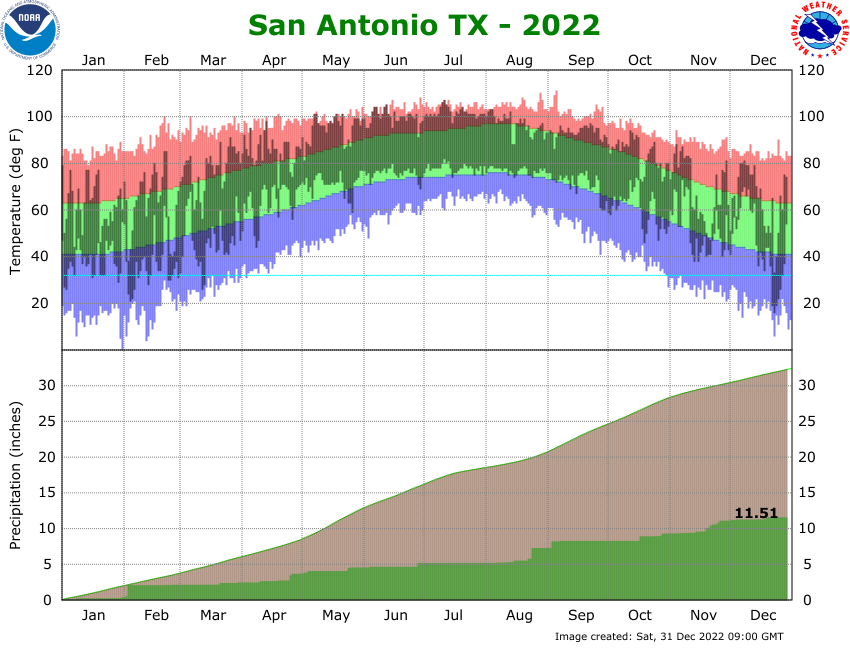
SAT is likely on pace for a top 5 driest year. (10.11" in 1917 is the all-time record). Can we go below 10"? I say yes.
0 likes
The above post is NOT an official forecast and should not be used as such. It is just the opinion of the poster and may or may not be backed by sound meteorological data. It is NOT endorsed by any professional institution including Storm2k. For official information, please refer to NWS products.

Re: Texas Summer 2022
Can someone please explain why there's a wall, west of 45? In my area (Cypress) I'm watching it light up like the 4th July and we're not getting anything. I just don't get it.
Last edited by SoupBone on Fri Jul 22, 2022 3:48 pm, edited 1 time in total.
0 likes
Personal Forecast Disclaimer:
The posts in this forum are NOT official forecast and should not be used as such. They are just the opinion of the poster and may or may not be backed by sound meteorological data. They are NOT endorsed by any professional institution or storm2k.org. For official information, please refer to the NHC and NWS products.
The posts in this forum are NOT official forecast and should not be used as such. They are just the opinion of the poster and may or may not be backed by sound meteorological data. They are NOT endorsed by any professional institution or storm2k.org. For official information, please refer to the NHC and NWS products.
-
weatherdude1108
- Category 5
- Posts: 4228
- Joined: Tue Dec 13, 2011 1:04 pm
- Location: Northwest Austin/Cedar Park, TX
Re: Texas Summer 2022
SoupBone wrote:Can someone please explain why there's a wall, west of 45? In my area (Cypress) I'm watching it light up like the 4th July abs we're not getting anything. I just don't get it.
Death ridge influence? I hate that ridge.
1 likes
The preceding post is NOT an official forecast, and should not be used as such. It is only the opinion of the poster and may or may not be backed by sound meteorological data. It is NOT endorsed by any professional institution including storm2k.org. For Official Information please refer to the NHC and NWS products.
-
Iceresistance
- Category 5
- Posts: 9592
- Age: 22
- Joined: Sat Oct 10, 2020 9:45 am
- Location: Tecumseh, OK/Norman, OK
Re: Texas Summer 2022
weatherdude1108 wrote:SoupBone wrote:Can someone please explain why there's a wall, west of 45? In my area (Cypress) I'm watching it light up like the 4th July abs we're not getting anything. I just don't get it.
Death ridge influence? I hate that ridge.
The cockroach death ridge to be exact, the same is going on in my area with the rain except it's even more localized. Rain and storms all around, but not here.
EDIT: Heard some thunder just to the east of my location, Radar has a really good storm near Earlsboro and Shawnee but I don't think it's coming to my location sadly.
0 likes
Bill 2015 & Beta 2020
Winter 2020-2021
All observations are in Tecumseh, OK unless otherwise noted.
Winter posts are focused mainly for Oklahoma & Texas.
Take any of my forecasts with a grain of salt, refer to the NWS, SPC, and NHC for official information
Never say Never with weather! Because ANYTHING is possible!
Winter 2020-2021
All observations are in Tecumseh, OK unless otherwise noted.
Winter posts are focused mainly for Oklahoma & Texas.
Take any of my forecasts with a grain of salt, refer to the NWS, SPC, and NHC for official information
Never say Never with weather! Because ANYTHING is possible!
-
Iceresistance
- Category 5
- Posts: 9592
- Age: 22
- Joined: Sat Oct 10, 2020 9:45 am
- Location: Tecumseh, OK/Norman, OK
Re: Texas Summer 2022
Finally! It's raining at the house!
1 likes
Bill 2015 & Beta 2020
Winter 2020-2021
All observations are in Tecumseh, OK unless otherwise noted.
Winter posts are focused mainly for Oklahoma & Texas.
Take any of my forecasts with a grain of salt, refer to the NWS, SPC, and NHC for official information
Never say Never with weather! Because ANYTHING is possible!
Winter 2020-2021
All observations are in Tecumseh, OK unless otherwise noted.
Winter posts are focused mainly for Oklahoma & Texas.
Take any of my forecasts with a grain of salt, refer to the NWS, SPC, and NHC for official information
Never say Never with weather! Because ANYTHING is possible!
-
Iceresistance
- Category 5
- Posts: 9592
- Age: 22
- Joined: Sat Oct 10, 2020 9:45 am
- Location: Tecumseh, OK/Norman, OK
Re: Texas Summer 2022
Just checked the rain gauge, .3 inches! 
1 likes
Bill 2015 & Beta 2020
Winter 2020-2021
All observations are in Tecumseh, OK unless otherwise noted.
Winter posts are focused mainly for Oklahoma & Texas.
Take any of my forecasts with a grain of salt, refer to the NWS, SPC, and NHC for official information
Never say Never with weather! Because ANYTHING is possible!
Winter 2020-2021
All observations are in Tecumseh, OK unless otherwise noted.
Winter posts are focused mainly for Oklahoma & Texas.
Take any of my forecasts with a grain of salt, refer to the NWS, SPC, and NHC for official information
Never say Never with weather! Because ANYTHING is possible!
Return to “USA & Caribbean Weather”
Who is online
Users browsing this forum: Google [Bot] and 209 guests