Texas Spring 2025
Moderator: S2k Moderators
Forum rules

The posts in this forum are NOT official forecast and should not be used as such. They are just the opinion of the poster and may or may not be backed by sound meteorological data. They are NOT endorsed by any professional institution or STORM2K.
-
Stratton23
- Category 5

- Posts: 3517
- Joined: Fri Jul 21, 2023 10:59 pm
- Location: Katy, Tx
Re: Texas Spring 2025
After taking a good look at the latest GFS / Euro runs, this wet weather pattern is easily going to carry over well into May, both models show a pronounced weakness remaining over the state for the next 2-3 weeks at the very least, daily chances for storms and at times widespread heavier rains on both models for the whole state, my confidence is pretty high we arent going into summer with significant drought issues
0 likes
-
rwfromkansas
- Category 5
- Posts: 3020
- Joined: Sat Aug 27, 2005 12:47 am
- Location: North Fort Worth
Re: Texas Spring 2025
1.30 IMBY overnight. Much more than the Easter rain. Lol.
Glad the storms held together.
Glad the storms held together.
0 likes
-
Edwards Limestone

- S2K Supporter

- Posts: 505
- Age: 36
- Joined: Tue Dec 28, 2021 11:05 am
- Location: Smithson Valley, TX
Re: Texas Spring 2025
https://x.com/NWSMidland/status/1915139272266445225

https://www.spc.noaa.gov/products/md/md0527.html
Mesoscale Discussion 0527
NWS Storm Prediction Center Norman OK
0214 PM CDT Wed Apr 23 2025
Areas affected...far southwestern Texas
Concerning...Severe potential...Watch possible
Valid 231914Z - 232115Z
Probability of Watch Issuance...60 percent
SUMMARY...Risk for gusty winds and large hail possible this
afternoon.
DISCUSSION...Deepening cumulus is observed across the Davis
Mountains and ahead of the surface dryline across far western Texas.
Temperatures have warmed into the upper 70s to 80s which has led to
weakening of MLCIN across the region. Convective initiation should
occur in the next 1-2 hours. Ahead of the dryline, MLCAPE around
1000-2000 J/kg with deep layer shear around 35-40 kts. This will
support supercells capable of large hail (some very large) and
damaging winds, given steep lapse rates around 8-9 C/km. A watch may
be needed in the coming hour.
..Thornton/Hart.. 04/23/2025
...Please see http://www.spc.noaa.gov for graphic product...
ATTN...WFO...EWX...SJT...MAF...
LAT...LON 30330471 30990414 31950309 32260227 32150132 31850105
31120102 30030192 29950220 29710318 29590373 29610402
29750447 30330471
MOST PROBABLE PEAK TORNADO INTENSITY...UP TO 95 MPH
MOST PROBABLE PEAK WIND GUST...65-80 MPH
MOST PROBABLE PEAK HAIL SIZE...1.50-2.50 IN
https://www.spc.noaa.gov/products/md/md0527.html
0 likes
The above post is NOT an official forecast and should not be used as such. It is just the opinion of the poster and may or may not be backed by sound meteorological data. It is NOT endorsed by any professional institution including Storm2k. For official information, please refer to NWS products.
-
txtwister78

- Category 5
- Posts: 2159
- Joined: Wed Jan 30, 2019 12:56 pm
- Location: San Antonio
Re: Texas Spring 2025
South Texas Storms wrote:txtwister78 wrote:South Texas Storms wrote:
I'm afraid it's going to pass north of town but hope I'm wrong. The Hill Country over to Austin looks to be in a good spot right now. DFW too.
Trends looking good so far. Movement has been more SE than due east. All about whether it survives the trip now.
Yep, good call! Looks like the outflow boundary pushed far enough south to allow the storms to build even south of SA. Another surprise beneficial rain event across much of south central Texas...you love to see it!
Yeah definitely take every drop we can get especially with models all over the place. Hopefully more on the way. Few showers this afternoon but atmosphere worked over a bit so probably won't get much out of these.
Have to see what happens out west again
2 likes
-
TomballEd
- Category 5
- Posts: 1261
- Age: 62
- Joined: Wed Aug 16, 2023 4:52 pm
- Location: Spring/Klein area, not Tomball
Re: Texas Spring 2025
Felt like more than 0.55 fell here. I'm half a mile from IAH. Electronics were off for the STAAR test. IAH got 0.55 inches. It was mostly light to moderate rain that fell for two hours, but there were some brief (under 5 minute) heavier showers.
1 likes
-
rwfromkansas
- Category 5
- Posts: 3020
- Joined: Sat Aug 27, 2005 12:47 am
- Location: North Fort Worth
Re: Texas Spring 2025
What’s next? Another overnight MCS or later? POW seems to indicate closer to noon tomorrow for DFW. Hope so.
Tired of my dogs barking constantly overnight. They don’t seem to mind thunder during the day. Need to get a puppy trainer on this. lol.
Tired of my dogs barking constantly overnight. They don’t seem to mind thunder during the day. Need to get a puppy trainer on this. lol.
1 likes
-
HockeyTx82
- S2K Supporter
- Posts: 2782
- Joined: Tue Oct 27, 2009 11:17 am
- Location: Ponder, TX
Re: Texas Spring 2025
rwfromkansas wrote:What’s next? Another overnight MCS or later? POW seems to indicate closer to noon tomorrow for DFW. Hope so.
Tired of my dogs barking constantly overnight. They don’t seem to mind thunder during the day. Need to get a puppy trainer on this. lol.
My dog is pushing 15 years old. She has always barked. I let her outside before the storms hit this morning, watched her use the restroom and she still managed to poop and pee in the house.
0 likes
Don't hold me accountable for anything I post on this forum. Leave the real forecasting up to the professionals.
Location: Ponder, TX (all observation posts are this location unless otherwise noted)
Location: Ponder, TX (all observation posts are this location unless otherwise noted)
Re: Texas Spring 2025
rwfromkansas wrote:What’s next? Another overnight MCS or later? POW seems to indicate closer to noon tomorrow for DFW. Hope so.
Tired of my dogs barking constantly overnight. They don’t seem to mind thunder during the day. Need to get a puppy trainer on this. lol.
Some day storms would be great. I've forgotten what they are. Not complaining with the rain but it would be nice to witness storms during the daylight.
0 likes
Re: Texas Spring 2025
rwfromkansas wrote:What’s next? Another overnight MCS or later? POW seems to indicate closer to noon tomorrow for DFW. Hope so.
Tired of my dogs barking constantly overnight. They don’t seem to mind thunder during the day. Need to get a puppy trainer on this. lol.
I would just like to get an actual t-storm.
0 likes
-
TomballEd
- Category 5
- Posts: 1261
- Age: 62
- Joined: Wed Aug 16, 2023 4:52 pm
- Location: Spring/Klein area, not Tomball
Re: Texas Spring 2025
Possibly more significant rain for NTX today, and severe and flooding hazards may follow next week.
https://x.com/JimCantore/status/1915328334965133715
https://x.com/JimCantore/status/1915328334965133715
1 likes

Re: Texas Spring 2025
HRRR looks good for the MCS to continue across N/NETX today. Hope so, I've had 0.3" over the last couple of weeks.
0 likes
-
TomballEd
- Category 5
- Posts: 1261
- Age: 62
- Joined: Wed Aug 16, 2023 4:52 pm
- Location: Spring/Klein area, not Tomball
Re: Texas Spring 2025
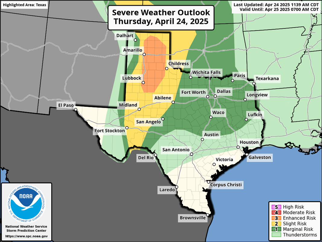
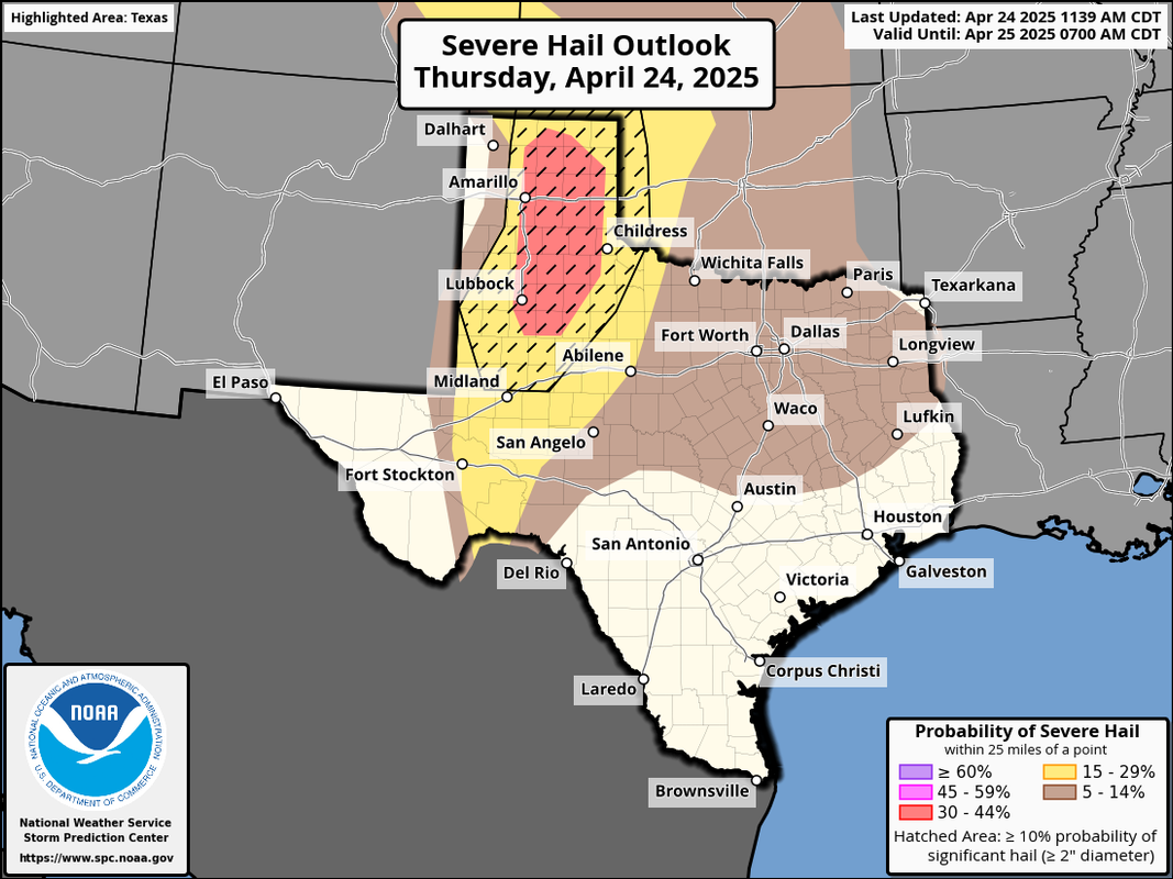
https://x.com/NWSSPC/status/1915428281093967939
Mesoscale Discussion 0540
NWS Storm Prediction Center Norman OK
1029 AM CDT Thu Apr 24 2025
Areas affected...parts of cntrl into nern TX
Concerning...Severe potential...Watch unlikely
Valid 241529Z - 241800Z
Probability of Watch Issuance...20 percent
SUMMARY...Ongoing thunderstorm development appears likely to
persist, with at least a gradual continuing upscale growth,
intensification and organization possible through 1-3 PM CDT. This
may be accompanied by the risk for severe hail, and increasing
potential for strong wind gusts later this afternoon. It is not
certain if or when a severe weather watch will be needed, but trends
are being monitored.
DISCUSSION...Forcing for ascent, largely driven by
lower/mid-tropospheric warm advection, is maintaining vigorous
thunderstorm development across parts of west central Texas,
near/south of Abilene toward the Stephenville area. This has been
focused above relatively cool convective outflow, near the eastern
periphery of a plume of warm and more strongly capping elevated
mixed-layer air across the lower Rio Grande Valley through Texas
South Plains.
This plume is forecast to continue to slowly spread eastward across
the southern Great Plains through mid afternoon. At the same time,
however, a seasonably moist boundary layer to the south and east of
the convective outflow will continue to destabilize with daytime
heating, with CAPE likely to increase in excess of 1500 J/kg.
As the forcing for ascent spreads slowly eastward, there appears
potential for substantive intensification and upscale growth of
ongoing convective development as southeasterly low-level updraft
inflow continues to destabilize. However, the extent to which this
may be countered by warming mid-levels remains unclear, but this may
primarily just impact how soon this afternoon thunderstorm activity
undergoes more notable intensification.
Once this occurs, 20-25 kt westerly deep-layer mean flow is modestly
sheared, and probably to sufficient to contribute to a risk for
severe hail in the more discrete initial intensifying cells.
Gradually, a growing cluster may begin to organize, including the
evolution of an MCV and strengthening surface cold pool accompanied
by increasing potential for strong surface gusts.
..Kerr/Smith.. 04/24/2025
0 likes
Re: Texas Spring 2025
Sirens just went off here in GP for about a minute. Nice looking cluster moving in but doesn't look tornadic. Finally some day storms!!!!
2 likes


Re: Texas Spring 2025
Analogs support a wet period to begin May. Raised heights over the PAC NW is favorable for us. Still don't see anything apocalyptic with severe weather, but localized pockets with these rain events, which should be expected given late Spring. Is it just me or instability seems to be lower than normal?
1 likes
The above post and any post by Ntxw is NOT an official forecast and should not be used as such. It is just the opinion of the poster and may or may not be backed by sound meteorological data. It is NOT endorsed by any professional institution including Storm2k. For official information, please refer to NWS products.
Help support Storm2K!
-
txtwister78
- Category 5
- Posts: 2159
- Joined: Wed Jan 30, 2019 12:56 pm
- Location: San Antonio
Re: Texas Spring 2025
May have to wait until next week when the active pattern up north & west shifts a little further south/east (at least per the models) for some additional rainfall chances unless of course one of these late afternoon/early evening storm complexes out west surprises.us again overnight.
1 likes
-
Stratton23
- Category 5
- Posts: 3517
- Joined: Fri Jul 21, 2023 10:59 pm
- Location: Katy, Tx
Re: Texas Spring 2025
Man if that 12z Euro is right about late april- early May , that could be an extremely wet period for central/ se texas , cut off low gets trapped in the desert SW
0 likes
-
mmmmsnouts
- Tropical Storm

- Posts: 213
- Joined: Tue Sep 05, 2023 10:04 pm
- Location: Arlington, TX
Re: Texas Spring 2025
Looks like the strike zone this afternoon is a little bit south of DFW. Which is fine, they need rain more than we do.
0 likes
Return to “USA & Caribbean Weather”
Who is online
Users browsing this forum: 869MB and 84 guests