C/S TX Weather: Seasonal with some rains
Moderator: S2k Moderators
Forum rules
The posts in this forum are NOT official forecast and should not be used as such. They are just the opinion of the poster and may or may not be backed by sound meteorological data. They are NOT endorsed by any professional institution or STORM2K.
- somethingfunny
- ChatStaff
- Posts: 3926
- Age: 36
- Joined: Thu May 31, 2007 10:30 pm
- Location: McKinney, Texas
Re: C/SC TX Weather: Frying Pan Summer
Everything's hotter in Texas!
0 likes
I am not a meteorologist, and any posts made by me are not official forecasts or to be interpreted as being intelligent. These posts are just my opinions and are probably silly opinions.
- South Texas Storms
- Professional-Met
- Posts: 4040
- Joined: Thu Jun 24, 2010 12:28 am
- Location: Houston, TX
Re: C/SC TX Weather: Frying Pan Summer
Can we please have the opposite weather of what we have now? I would love to have some well below average temperatures and the rain to come down in buckets every day!
0 likes
- Tireman4
- S2K Supporter
- Posts: 5679
- Age: 58
- Joined: Fri Jun 30, 2006 1:08 pm
- Location: Humble, Texas
- Contact:
Re: C/SC TX Weather: Frying Pan Summer
South Texas Storms wrote:Can we please have the opposite weather of what we have now? I would love to have some well below average temperatures and the rain to come down in buckets every day!
Not until Labor Day, according to Larry Cosgrove...
0 likes
- Portastorm
- Storm2k Moderator
- Posts: 9788
- Age: 62
- Joined: Fri Jul 11, 2003 9:16 am
- Location: South Austin, TX
- Contact:
Re: C/SC TX Weather: Frying Pan Summer
URGENT - WEATHER MESSAGE
NATIONAL WEATHER SERVICE AUSTIN/SAN ANTONIO TX
310 PM CDT MON AUG 1 2011
...A HEAT ADVISORY IS IN EFFECT FOR ALL OF SOUTH CENTRAL TEXAS AND
THE HILL COUNTRY FROM NOON TUESDAY UNTIL 10 PM FRIDAY...
.A HIGH PRESSURE RIDGE STRETCHED ACROSS THE SOUTHERN PLAINS WILL
LEAD TO VERY HOT TEMPERATURES ACROSS SOUTH CENTRAL TEXAS AND THE
HILL COUNTRY. AFTERNOON HIGH TEMPERATURES ARE EXPECTED TO BE NEAR
OR ABOVE RECORDS THROUGH THE REST OF THE WEEK. TEMPERATURES EACH
MORNING WILL BRIEFLY FALL BELOW 80 DEGREES...WITH RAPID WARMING
EXPECTED AFTER SUNRISE. EACH DAY...HEAT INDEX READINGS WILL RISE
TO ABOVE 100 BY NOON...AND REACH 105 TO NEAR 110 BY MID AFTERNOON.
LLANO-BURNET-WILLIAMSON-VAL VERDE-EDWARDS-REAL-KERR-BANDERA-
GILLESPIE-KENDALL-BLANCO-HAYS-TRAVIS-BASTROP-LEE-KINNEY-UVALDE-
MEDINA-BEXAR-COMAL-GUADALUPE-CALDWELL-FAYETTE-MAVERICK-ZAVALA-
FRIO-ATASCOSA-WILSON-KARNES-GONZALES-DE WITT-LAVACA-DIMMIT-
INCLUDING THE CITIES OF...LLANO...BURNET...GEORGETOWN...DEL RIO...
ROCKSPRINGS...LEAKEY...KERRVILLE...BANDERA...FREDERICKSBURG...
BOERNE...BLANCO...SAN MARCOS...AUSTIN...BASTROP...GIDDINGS...
BRACKETTVILLE...UVALDE...HONDO...SAN ANTONIO...NEW BRAUNFELS...
SEGUIN...LOCKHART...LA GRANGE...EAGLE PASS...CRYSTAL CITY...
PEARSALL...PLEASANTON...FLORESVILLE...KARNES CITY...GONZALES...
CUERO...HALLETTSVILLE...CARRIZO SPRINGS
310 PM CDT MON AUG 1 2011
...HEAT ADVISORY IN EFFECT FROM NOON TUESDAY TO 10 PM CDT
FRIDAY...
THE NATIONAL WEATHER SERVICE IN AUSTIN/SAN ANTONIO HAS ISSUED A
HEAT ADVISORY...WHICH IS IN EFFECT FROM NOON TUESDAY TO 10 PM CDT
FRIDAY.
* EVENT...AFTERNOON AND EARLY EVENING HEAT INDEX VALUES WILL RISE
TO OR EXCEED 105 DEGREES THROUGH FRIDAY. HIGHS THIS WEEK ARE
EXPECTED TO APPROACH OR EXCEED RECORD LEVELS EACH DAY. LOW
TEMPERATURES OVERNIGHT ARE ONLY EXPECTED TO FALL INTO THE MID
AND UPPER 70S AND WILL LIKELY REMAIN NEAR 80 IN URBAN AREAS.
* TIMING...TUESDAY AFTERNOON THROUGH FRIDAY EVENING.
* IMPACT...HEAT STROKE...HEAT CRAMPS...OR HEAT EXHAUSTION IS
LIKELY WITH PROLONGED EXPOSURE AND PHYSICAL ACTIVITY.
PRECAUTIONARY/PREPAREDNESS ACTIONS...
TAKE EXTRA PRECAUTIONS IF YOU WORK OR SPEND TIME OUTSIDE. WHEN
POSSIBLE...RESCHEDULE STRENUOUS ACTIVITIES TO EARLY MORNING OR
EVENING. KNOW THE SIGNS AND SYMPTOMS OF HEAT EXHAUSTION AND HEAT
STROKE. WEAR LIGHT WEIGHT AND LOOSE FITTING CLOTHING WHEN
POSSIBLE AND DRINK PLENTY OF WATER. TO REDUCE RISK DURING OUTDOOR
WORK THE OCCUPATIONAL SAFETY AND HEALTH ADMINISTRATION RECOMMENDS
SCHEDULING FREQUENT REST BREAKS IN SHADED OR AIR CONDITIONED
ENVIRONMENTS. ANYONE OVERCOME BY HEAT SHOULD BE MOVED TO A COOL
AND SHADED LOCATION. HEAT STROKE IS AN EMERGENCY...CALL 911.
0 likes
Any forecasts under my name are to be taken with a grain of salt. Get your best forecasts from the National Weather Service and National Hurricane Center.
I'm a certified Advanced SKYWARN-trained spotter and am active on Twitter at @TravisCOSW, a social media partner of the NWS Austin-San Antonio office.
Mon: Day 48
Mabry 107 (record) Bergstrom 105 (record)
It was 107 (record) at DFW where they are on their 31st day in a row 100+
We had 2 days in July that were 99 or we'd have more than that.
Currently we are on Day 16 in a row 100+ (I can't remember the record. 22? if so we very well may at least tie it)
Mabry 107 (record) Bergstrom 105 (record)
It was 107 (record) at DFW where they are on their 31st day in a row 100+
We had 2 days in July that were 99 or we'd have more than that.
Currently we are on Day 16 in a row 100+ (I can't remember the record. 22? if so we very well may at least tie it)
0 likes
- Rgv20
- S2K Supporter
- Posts: 2458
- Age: 37
- Joined: Wed Jan 05, 2011 5:42 pm
- Location: Edinburg/McAllen Tx
Looks like North Texas and Oklahoma are going to get the brunt of this Heat Wave. GFS Ensembles for the next 14 days have high temperatures running 6 to 9 degrees Celsius above normal.
0 likes
The following post is NOT an official forecast and should not be used as such. It is just the opinion of the poster and may or may not be backed by sound meteorological data. It is NOT endorsed by any professional institution including storm2k.org For Official Information please refer to the NHC and NWS products.
- Portastorm
- Storm2k Moderator
- Posts: 9788
- Age: 62
- Joined: Fri Jul 11, 2003 9:16 am
- Location: South Austin, TX
- Contact:
Re:
Shoshana wrote:Mon: Day 48
Mabry 107 (record) Bergstrom 105 (record)
It was 107 (record) at DFW where they are on their 31st day in a row 100+
We had 2 days in July that were 99 or we'd have more than that.
Currently we are on Day 16 in a row 100+ (I can't remember the record. 22? if so we very well may at least tie it)
KXAN-TV mets say the record for consecutive high temp days of 100 or more is 21 days. I'm thinking we're going to easily beat the record.
0 likes
Any forecasts under my name are to be taken with a grain of salt. Get your best forecasts from the National Weather Service and National Hurricane Center.
I'm a certified Advanced SKYWARN-trained spotter and am active on Twitter at @TravisCOSW, a social media partner of the NWS Austin-San Antonio office.
Re: C/SC TX Weather: Frying Pan Summer
It is so sad when the NWS here has to talk about a south/se east wind for cold air advection lol. I hope we break records (Texas and Oklahoma). I know it sounds harsh but if it's going to be hot anyway might as well. 110 and 113 don't feel much diff tbh and 18 days or 21 days isn't that much of a change either...sigh
FW NWS
FW NWS
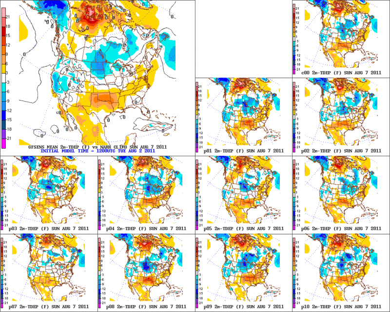
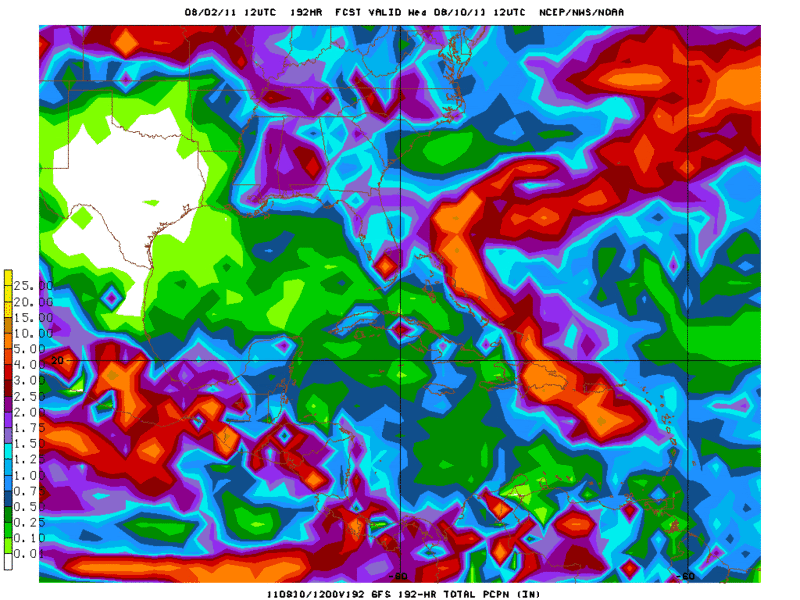
.PREV DISCUSSION... /ISSUED 359 AM CDT TUE AUG 2 2011/
00Z UPPER AIR ANALYSIS SHOWS STRONG VERTICALLY STACKED ANTICYCLONE
PLANTED OVER SOUTHEAST OKLAHOMA AND NORTHEAST TEXAS. LOCATION OF
THE 850MB HIGH IS RESULTING IN VERY WEAK AND CONFUSED FLOW OVER
THE EASTERN HALF OF TEXAS WHICH IS PREVENTING INTRUSION OF THE
COOLER AIR OVER THE GULF INTO NORTH TEXAS. THUS THE BUBBLE OF VERY
HOT AIR BELOW 700MB WILL CONTINUE TO WARM WITH EACH DAY/S WORTH OF
INSOLATION UNTIL WE CAN GET SOME DECENT WIND FROM THE SOUTH AND
SOUTHEAST TO SUPPLY SOME COLD ADVECTION. MODELS CONTINUE TO AGREE
THAT THIS WILL NOT OCCUR UNTIL WEDNESDAY NIGHT WHEN 10-15KT OF
S/SE FLOW AT 850MB BEGINS TO MATERIALIZE AS THE 850MB HIGH SHIFTS
INTO LOUISIANA. THEREFORE THE HOTTEST DAYS SHOULD BE TODAY AND
TOMORROW...WITH A VERY SLIGHT COOLING TREND OCCURRING THEREAFTER.
0 likes
The above post and any post by Ntxw is NOT an official forecast and should not be used as such. It is just the opinion of the poster and may or may not be backed by sound meteorological data. It is NOT endorsed by any professional institution including Storm2k. For official information, please refer to NWS products.
- Portastorm
- Storm2k Moderator
- Posts: 9788
- Age: 62
- Joined: Fri Jul 11, 2003 9:16 am
- Location: South Austin, TX
- Contact:
Re: C/SC TX Weather: Frying Pan Summer
The comment about winds from the south/southeast to supply cold air advection ... absolutely amazing! I never dreamed I would see such a thing. Wow.
0 likes
Any forecasts under my name are to be taken with a grain of salt. Get your best forecasts from the National Weather Service and National Hurricane Center.
I'm a certified Advanced SKYWARN-trained spotter and am active on Twitter at @TravisCOSW, a social media partner of the NWS Austin-San Antonio office.
^ 110 as of 4:00 pm. Tomorrow looks like the hottest day of the week.
0 likes
The above post and any post by Ntxw is NOT an official forecast and should not be used as such. It is just the opinion of the poster and may or may not be backed by sound meteorological data. It is NOT endorsed by any professional institution including Storm2k. For official information, please refer to NWS products.
- somethingfunny
- ChatStaff
- Posts: 3926
- Age: 36
- Joined: Thu May 31, 2007 10:30 pm
- Location: McKinney, Texas
Re:
Ntxw wrote:^ 110 as of 4:00 pm. Tomorrow looks like the hottest day of the week.
Only the 12th time the temperature has reached 110+ since records began in 1898...1980 had 5 of them. First time since 9/4/2000 as well.
Tomorrow may be this hot as well.
0 likes
I am not a meteorologist, and any posts made by me are not official forecasts or to be interpreted as being intelligent. These posts are just my opinions and are probably silly opinions.
- somethingfunny
- ChatStaff
- Posts: 3926
- Age: 36
- Joined: Thu May 31, 2007 10:30 pm
- Location: McKinney, Texas
Re: C/SC TX Weather: Frying Pan Summer
Texas Rain Gauge:
0 likes
I am not a meteorologist, and any posts made by me are not official forecasts or to be interpreted as being intelligent. These posts are just my opinions and are probably silly opinions.
- Rgv20
- S2K Supporter
- Posts: 2458
- Age: 37
- Joined: Wed Jan 05, 2011 5:42 pm
- Location: Edinburg/McAllen Tx
Well the heat continues with much of North Texas and Oklahoma hitting 108+!! I checked a few random weather observations and in Muskogee, Davis Field in Eastern Oklahoma had a high of 111 today!!!! Its getting ridiculous out there.
As we head thru the next five days temperature should start cooling off but still running above normal.
Day 5
Day 10
Day 15
As you can see on the pictures above, the 12zGFS Ensembles forecast for the heat to subside some but still calls for above normal temperatures for N Texas and Oklahoma thru the next 15 days.
Long range NAEFS Ensembles also agree with the GFS on above normal temperatures for Texas thru the next 6-14 days.
And just to add insult to injury here is the Total rainfall thru 8 days from the GFS with the Euro basically showing the same thing
0 likes
The following post is NOT an official forecast and should not be used as such. It is just the opinion of the poster and may or may not be backed by sound meteorological data. It is NOT endorsed by any professional institution including storm2k.org For Official Information please refer to the NHC and NWS products.
- South Texas Storms
- Professional-Met
- Posts: 4040
- Joined: Thu Jun 24, 2010 12:28 am
- Location: Houston, TX
Re: C/SC TX Weather: Frying Pan Summer
So sad and frustrating. As our local met. in SA said: "the dumb heat high looks to remain near us".
0 likes
- somethingfunny
- ChatStaff
- Posts: 3926
- Age: 36
- Joined: Thu May 31, 2007 10:30 pm
- Location: McKinney, Texas
- South Texas Storms
- Professional-Met
- Posts: 4040
- Joined: Thu Jun 24, 2010 12:28 am
- Location: Houston, TX
Re: C/SC TX Weather: Frying Pan Summer
From today's NWS Austin/SA morning AFD: NO HEAT OR DROUGHT RELEIF IS IN SIGHT FOR THE NEXT WEEK TO 10
DAYS. THE CENTER OF THE BROAD UPPER RIDGE WILL BE NEAR THE ARK-
LA-TEX...THEN SHIFTING SLOWLY WESTWARD OVER THE NEXT WEEK."
DAYS. THE CENTER OF THE BROAD UPPER RIDGE WILL BE NEAR THE ARK-
LA-TEX...THEN SHIFTING SLOWLY WESTWARD OVER THE NEXT WEEK."
0 likes
- Portastorm
- Storm2k Moderator
- Posts: 9788
- Age: 62
- Joined: Fri Jul 11, 2003 9:16 am
- Location: South Austin, TX
- Contact:
Re: C/SC TX Weather: Frying Pan Summer
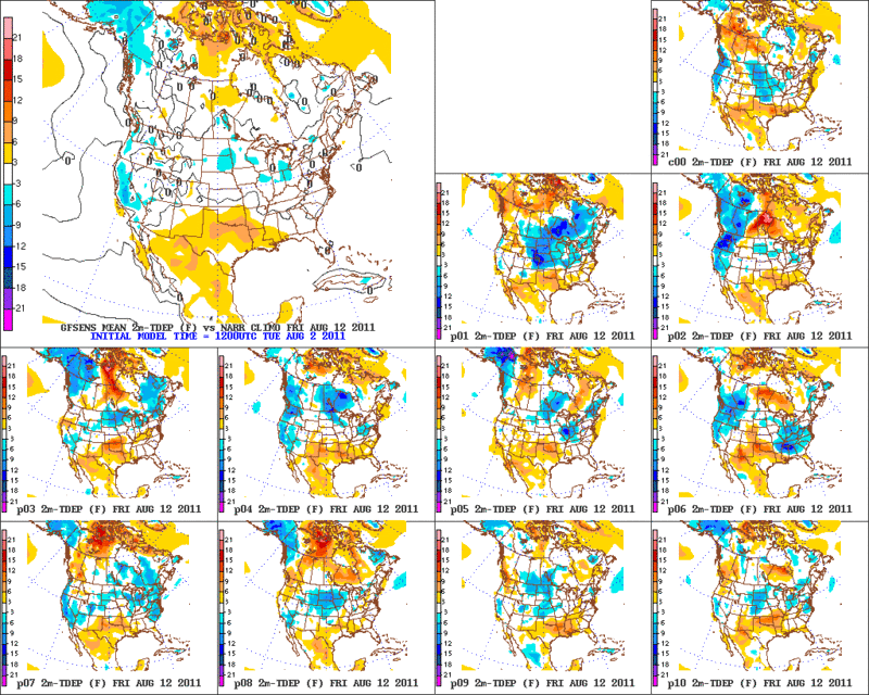
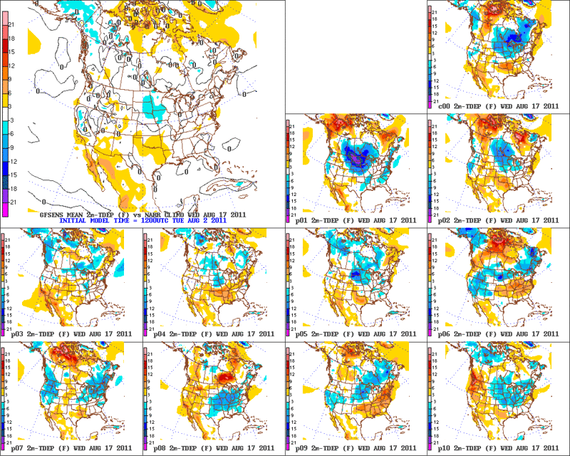
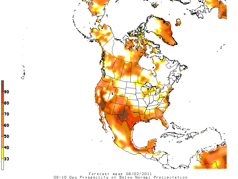
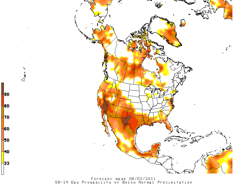
South Texas Storms wrote:From today's NWS Austin/SA morning AFD: NO HEAT OR DROUGHT RELEIF IS IN SIGHT FOR THE NEXT WEEK TO 10
DAYS. THE CENTER OF THE BROAD UPPER RIDGE WILL BE NEAR THE ARK-
LA-TEX...THEN SHIFTING SLOWLY WESTWARD OVER THE NEXT WEEK."
That was one of the first things I read this morning and my heart just sank.
0 likes
Any forecasts under my name are to be taken with a grain of salt. Get your best forecasts from the National Weather Service and National Hurricane Center.
I'm a certified Advanced SKYWARN-trained spotter and am active on Twitter at @TravisCOSW, a social media partner of the NWS Austin-San Antonio office.
Return to “USA & Caribbean Weather”
Who is online
Users browsing this forum: No registered users and 23 guests