Texas Summer 2012
Moderator: S2k Moderators
Forum rules

The posts in this forum are NOT official forecast and should not be used as such. They are just the opinion of the poster and may or may not be backed by sound meteorological data. They are NOT endorsed by any professional institution or STORM2K.
-
Nikki

- S2K Supporter

- Posts: 291
- Joined: Mon Jun 21, 2010 3:38 pm
- Location: Santa Fe, TX (yes I typed that right TEXAS not New Mexico, I am about 20 miles from Galveston, TX)
Re: Texas Summer 2012
My area did not see any rain either, so I feel your pain!! 
0 likes
My name is Nicole and this is what I go by in Storm2k chat! Come chat with us! We have fun in there too!!
A teacher's purpose is not to create students in her own image, but to develop students who can create their own image. ~Author Unknown
Alicia, Allison, Rita, Ike
A teacher's purpose is not to create students in her own image, but to develop students who can create their own image. ~Author Unknown
Alicia, Allison, Rita, Ike
-
Portastorm

- Storm2k Moderator

- Posts: 9954
- Age: 63
- Joined: Fri Jul 11, 2003 9:16 am
- Location: Round Rock, TX
- Contact:
Re: Texas Summer 2012
Yep ... the Portastorm Weather Center saw as much rain yesterday as we did snow last winter. Zilch!
0 likes
Any forecasts under my name are to be taken with a grain of salt. Get your best forecasts from the National Weather Service and National Hurricane Center.
-
weatherdude1108
- Category 5

- Posts: 4228
- Joined: Tue Dec 13, 2011 1:04 pm
- Location: Northwest Austin/Cedar Park, TX
Only thing that comes to mind (besides being cursed) is the topography of the hill country to our west and northwest. It provides the orographic lift of the moisture keeping them going. Once they move east into the flatter lands, they lose their buoyancy and go through a kind of compressional warming(?). I'm just guessing. I'm looking at the "donut" forming over Austin at the moment from a red cell that originated near Brady this morning. It's definitely too cool for any kind of "heat dome." I'm lost. 
0 likes
The preceding post is NOT an official forecast, and should not be used as such. It is only the opinion of the poster and may or may not be backed by sound meteorological data. It is NOT endorsed by any professional institution including storm2k.org. For Official Information please refer to the NHC and NWS products.
-
Portastorm
- Storm2k Moderator
- Posts: 9954
- Age: 63
- Joined: Fri Jul 11, 2003 9:16 am
- Location: Round Rock, TX
- Contact:
Re:
weatherdude1108 wrote:Only thing that comes to mind (besides being cursed) is the topography of the hill country to our west and northwest. It provides the orographic lift of the moisture keeping them going. Once they move east into the flatter lands, they lose their buoyancy and go through a kind of compressional warming(?). I'm just guessing. I'm looking at the "donut" forming over Austin at the moment from a red cell that originated near Brady this morning. It's definitely too cool for any kind of "heat dome." I'm lost.
Yeah ... how did you like that tease this morning? We see a healthy MCS rolling down the Big Country, southeast, into our area ... only to see it evaporate. It's maddening. Well, I'm happy for folks on the east side and they saw some rain last evening.
Eh, at least we're not baking like we were last summer at this time. I'll try to be a glass-half-full guy.
0 likes
Any forecasts under my name are to be taken with a grain of salt. Get your best forecasts from the National Weather Service and National Hurricane Center.
-
weatherdude1108
- Category 5
- Posts: 4228
- Joined: Tue Dec 13, 2011 1:04 pm
- Location: Northwest Austin/Cedar Park, TX
Re: Re:
Portastorm wrote:weatherdude1108 wrote:Only thing that comes to mind (besides being cursed) is the topography of the hill country to our west and northwest. It provides the orographic lift of the moisture keeping them going. Once they move east into the flatter lands, they lose their buoyancy and go through a kind of compressional warming(?). I'm just guessing. I'm looking at the "donut" forming over Austin at the moment from a red cell that originated near Brady this morning. It's definitely too cool for any kind of "heat dome." I'm lost.
Yeah ... how did you like that tease this morning? We see a healthy MCS rolling down the Big Country, southeast, into our area ... only to see it evaporate. It's maddening. Well, I'm happy for folks on the east side and they saw some rain last evening.
Eh, at least we're not baking like we were last summer at this time. I'll try to be a glass-half-full guy.
Yeah, I'm happy for those east of here who benefitted.
 The extra soil moisture around us should help us all out eventually.
Very true! We were in a perpetual furnace at this time last year.
 It definitely feels like a normal June this year THANKFULLY.
0 likes
-
Rgv20

- S2K Supporter
- Posts: 2466
- Age: 39
- Joined: Wed Jan 05, 2011 5:42 pm
- Location: Edinburg/McAllen Tx
The Heat continues for the RGV 
Special Weather Statement
SPECIAL WEATHER STATEMENT
NATIONAL WEATHER SERVICE BROWNSVILLE TX
440 AM CDT WED JUN 13 2012
TXZ248>257-131745-
ZAPATA-JIM HOGG-BROOKS-KENEDY-STARR-HIDALGO-INLAND WILLACY-
INLAND CAMERON-COASTAL WILLACY-COASTAL CAMERON-
INCLUDING THE CITIES OF...ZAPATA...HEBBRONVILLE...FALFURRIAS...
SARITA...RIO GRANDE CITY...ROMA...MCALLEN...EDINBURG...PHARR...
MISSION...WESLACO...RAYMONDVILLE...BROWNSVILLE...HARLINGEN...
PORT MANSFIELD...PORT ISABEL...SOUTH PADRE ISLAND...
LAGUNA HEIGHTS...LAGUNA VISTA
440 AM CDT WED JUN 13 2012
...HEAT INDEX VALUES BETWEEN 105 AND 110 DEGREES EXPECTED THIS AFTERNOON...
HOT CONDITIONS ARE EXPECTED TO CONTINUE ACROSS DEEP SOUTH TEXAS
TODAY. AFTERNOON TEMPERATURES OF 95 TO 100 DEGREES WILL COUPLE
WITH HUMIDITY TO PRODUCE HEAT INDEX VALUES BETWEEN 105 AND 110
DEGREES.
RESIDENTS WITH OUTDOOR ACTIVITIES PLANNED ARE URGED TO DRINK
PLENTY OF WATER...WEAR LIGHT WEIGHT AND LIGHT COLORED
CLOTHING...AND TAKE FREQUENT BREAKS FROM THE HEAT. YOUNG CHILDREN
AND PETS SHOULD NEVER BE LEFT UNATTENDED IN VEHICLES UNDER ANY
CIRCUMSTANCES. THIS IS ESPECIALLY TRUE DURING WARM OR HOT WEATHER
WHEN CAR INTERIORS CAN REACH LETHAL TEMPERATURES IN A MATTER OF
MINUTES.
$$
CASTILLO
0 likes
The following post is NOT an official forecast and should not be used as such. It is just the opinion of the poster and may or may not be backed by sound meteorological data. It is NOT endorsed by any professional institution including storm2k.org For Official Information please refer to the NHC and NWS products.
-
weatherdude1108
- Category 5
- Posts: 4228
- Joined: Tue Dec 13, 2011 1:04 pm
- Location: Northwest Austin/Cedar Park, TX
Keeping the glass half-full 
AREA FORECAST DISCUSSION
NATIONAL WEATHER SERVICE AUSTIN/SAN ANTONIO TX
301 PM CDT WED JUN 13 2012
.DISCUSSION...
WEAK LOW LEVEL FORCING IN NORTHWEST FLOW ALOFT MAY PRODUCE A
FEW SHOWERS AND/OR THUNDERSTORMS ACROSS THE NORTHEAST CORRIDOR EARLY
THIS EVENING...SO WILL INTRODUCE SLIGHT CHANCE POPS. ELSEWHERE NO
RAIN EXPECTED WITH LOWS IN THE 70S. THE UPPER RIDGE WILL DOMINATE
REGION DURING THE NEXT SEVERAL DAYS AS A SURFACE TROUGH OVER WEST
TEXAS...EASTERN NEW MEXICO PROMOTES CONTINUED MOIST SOUTHERLY LOW
LEVEL GULF FLOW. THIS WILL KEEP HIGHS NEAR SEASONAL NORMS THROUGH
THE WEEKEND AND LOWS A LITTLE WARMER THAN NORMAL FOR THIS TIME OF
YEAR. LOW LEVEL GULF MOISTURE INFLUX AND LARGE SCALE SUBSIDENCE
ALOFT MAY CREATE A LOW TO MID LAYER CAPPING INVERSION...THUS
MAKING IT SLOWER FOR LOW CLOUDS TO ERODE DURING THE NEXT SEVERAL
DAYS. BY SATURDAY...SEA BREEZE CONVECTION MAY DEVELOP INTO EASTERN
SECTIONS AS THE GULF FLOW BECOMES PERPENDICULAR TO THE TEXAS
COAST. A DISTURBANCE TRACKING WEST OVER THE NORTH CENTRAL GULF
COAST ON SUNDAY WILL LIKELY DISRUPT SOUTHEAST FLOW ALONG THE TEXAS
COAST SUNDAY AFTERNOON AND PREVENT A SEA BREEZE OCCURRENCE. MONDAY
AFTERNOON HOWEVER...A MORE FAVORABLE ENVIRONMENT WILL EXIST FOR A
SEA BREEZE MOVING INTO OUR EASTERN CWA. THE DISTURBANCE/EASTERLY
WAVE FEATURE WILL PUSH INLAND ALONG THE TEXAS COAST TUESDAY WITH
BETTER CHANCES FOR SHOWERS AND THUNDERSTORMS FURTHER WEST ALONG
THE I-35 CORRIDOR TUESDAY AFTERNOON AND EVEN FURTHER WEST NEXT
WEDNESDAY AS THE BROAD UPPER LOW SETTLES OVER SOUTH TEXAS.
0 likes
The preceding post is NOT an official forecast, and should not be used as such. It is only the opinion of the poster and may or may not be backed by sound meteorological data. It is NOT endorsed by any professional institution including storm2k.org. For Official Information please refer to the NHC and NWS products.
-
somethingfunny

- ChatStaff

- Posts: 3926
- Age: 37
- Joined: Thu May 31, 2007 10:30 pm
- Location: McKinney, Texas
Re: Texas Summer 2012
FWD says:
FOR THE REST OF THE FORECAST PERIOD...THURSDAY NIGHT THROUGH NEXT
WEDNESDAY...A LATE SEASON CUT OFF UPPER LOW DEVELOPS OVER
SOUTHERN CALIFORNIA AND THEN RETROGRADES WESTWARD WHILE UPPER
RIDGING BUILDS OVER THE SOUTHERN PLAINS AND MERGES WITH A PACIFIC
RIDGE REPLACES THE RETROGRADING UPPER LOW. BY EARLY NEXT
WEEK...THE UPPER HIGH WILL SLIDE WESTWARD AND LEAVE NORTH TEXAS
UNDER WEAK LOW PRESSURE ALOFT THE REST OF NEXT WEEK. LONG RANGE
MODELS OF THE PAST SEVERAL RUNS ARE INDICATING A TROPICAL SYSTEM
DEVELOPING NEAR YUCATAN ON WEDNESDAY THAT MOVES NORTHWARD TOWARD
THE TEXAS OR LOUISIANA COAST BY NEXT WEEKEND.
0 likes
I am not a meteorologist, and any posts made by me are not official forecasts or to be interpreted as being intelligent. These posts are just my opinions and are probably silly opinions.
-
vbhoutex

- Storm2k Executive

- Posts: 29145
- Age: 74
- Joined: Wed Oct 09, 2002 11:31 pm
- Location: Cypress, TX
- Contact:
Re: Texas Summer 2012
somethingfunny wrote:FWD says:FOR THE REST OF THE FORECAST PERIOD...THURSDAY NIGHT THROUGH NEXT
WEDNESDAY...A LATE SEASON CUT OFF UPPER LOW DEVELOPS OVER
SOUTHERN CALIFORNIA AND THEN RETROGRADES WESTWARD WHILE UPPER
RIDGING BUILDS OVER THE SOUTHERN PLAINS AND MERGES WITH A PACIFIC
RIDGE REPLACES THE RETROGRADING UPPER LOW. BY EARLY NEXT
WEEK...THE UPPER HIGH WILL SLIDE WESTWARD AND LEAVE NORTH TEXAS
UNDER WEAK LOW PRESSURE ALOFT THE REST OF NEXT WEEK. LONG RANGE
MODELS OF THE PAST SEVERAL RUNS ARE INDICATING A TROPICAL SYSTEM
DEVELOPING NEAR YUCATAN ON WEDNESDAY THAT MOVES NORTHWARD TOWARD
THE TEXAS OR LOUISIANA COAST BY NEXT WEEKEND.
0 likes
Skywarn, C.E.R.T.
Please click below to donate to STORM2K to help with the expenses of keeping the site going:

Please click below to donate to STORM2K to help with the expenses of keeping the site going:
-
SaskatchewanScreamer
so instead one more time for the rest of Texas
http://www.youtube.com/watch?feature=player_embedded&v=xlTcStnn6Mw
would love to see Amarillo get this as well .... my city and Amarillo share one item in common:
Salt Lake City, Denver, Boise, Los Angeles and Amarillo all have an aridity index in the 0.2 to 0.5 range. The Canadian cities of Medicine Hat, Moose Jaw and surrounding areas fall in this range as well. Micro climates cause some variation - think oasis.
http://www.stuffintheair.com/aridity-index.html
Well most years.
.
0 likes

Re:
weatherdude1108 wrote:Only thing that comes to mind (besides being cursed) is the topography of the hill country to our west and northwest. It provides the orographic lift of the moisture keeping them going. Once they move east into the flatter lands, they lose their buoyancy and go through a kind of compressional warming(?). I'm just guessing. I'm looking at the "donut" forming over Austin at the moment from a red cell that originated near Brady this morning. It's definitely too cool for any kind of "heat dome." I'm lost.
It is amazing how many times I have seen storms on radar over the hill country moving east only to fall apart just as they reach Austin. I am no scientist but it makes me wonder if it has something to do with the elevation of the land beginning to flatten out from Austin eastward. Maybe it changes the air flow or updrafts or something that causes the storms to weaken.
0 likes
Any opinions stated are those of an amateur, please take with several grains of salt and for official forecast refer to the National Weather Service.

Was driving home here east of the airport in Irving. Had tennis ball hail pelting my car...joy. Hopefully nothing too bad dent wise.
0 likes
The above post and any post by Ntxw is NOT an official forecast and should not be used as such. It is just the opinion of the poster and may or may not be backed by sound meteorological data. It is NOT endorsed by any professional institution including Storm2k. For official information, please refer to NWS products.
Help support Storm2K!
-
Rgv20
- S2K Supporter
- Posts: 2466
- Age: 39
- Joined: Wed Jan 05, 2011 5:42 pm
- Location: Edinburg/McAllen Tx
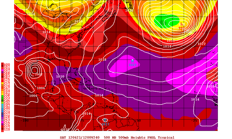
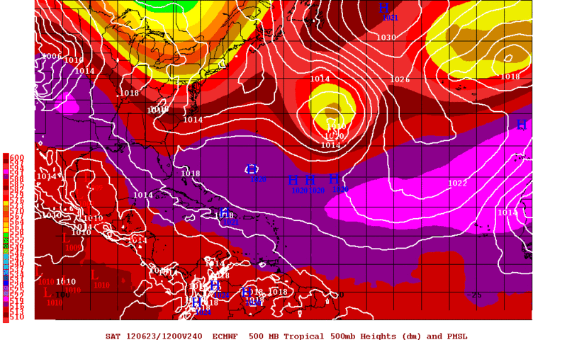
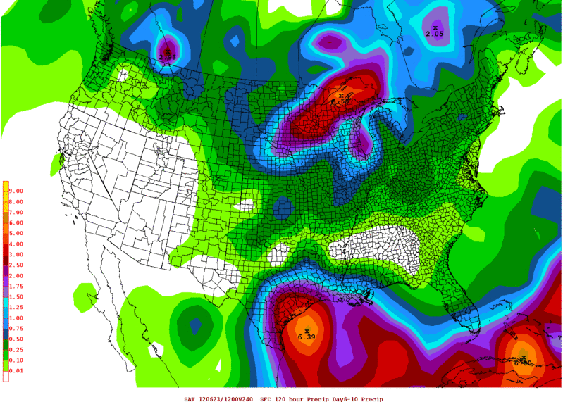
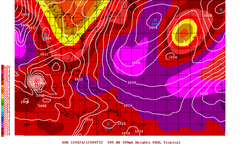
In my opinion all folks in the Texas coast need to keep an eye on the GOM next week. 12zGFS is very bullish with a TC affecting South Texas and the 12zECMWF is not as aggressive but shows a lot of Tropical moisture heading to Texas by late next week.
12zGFS Forecast valid next Saturday morning....Full blow Tropical system.
12zECMWF Forecast valid for next Saturday morning...A lot more conservative than the GFS.
12zGFS Forecast Rainfall Totals in the 6-10 day time frame....Those sure look nice!
12zGFS Forecast valid next Saturday morning....Full blow Tropical system.
12zECMWF Forecast valid for next Saturday morning...A lot more conservative than the GFS.
12zGFS Forecast Rainfall Totals in the 6-10 day time frame....Those sure look nice!
0 likes
The following post is NOT an official forecast and should not be used as such. It is just the opinion of the poster and may or may not be backed by sound meteorological data. It is NOT endorsed by any professional institution including storm2k.org For Official Information please refer to the NHC and NWS products.
Re: Texas Summer 2012
For those in Grand Prairie and Arlington
SEVERE WEATHER STATEMENT
NATIONAL WEATHER SERVICE FORT WORTH TX
750 PM CDT WED JUN 13 2012
TXC113-140115-
/O.CON.KFWD.SV.W.0196.000000T0000Z-120614T0115Z/
DALLAS TX-
750 PM CDT WED JUN 13 2012
...A SEVERE THUNDERSTORM WARNING REMAINS IN EFFECT UNTIL 815 PM CDT
FOR SOUTHERN DALLAS COUNTY...
AT 749 PM CDT...A SEVERE THUNDERSTORM WAS REPORTED CAPABLE OF
PRODUCING BASEBALL SIZE HAIL...AND DESTRUCTIVE WINDS IN EXCESS OF 70
MPH. THIS STORM WAS LOCATED NEAR GRAND PRAIRIE...MOVING SOUTH AT 15
MPH. HAIL OF 3 INCHES IN DIAMETER WAS REPORTED IN GRAND PRAIRIE!
SEEK SHELTER NOW!
THE SEVERE THUNDERSTORM WILL BE NEAR...
DUNCANVILLE AND HUTCHINS AROUND 800 PM CDT...
PRECAUTIONARY/PREPAREDNESS ACTIONS...
THIS STORM HAS A HISTORY OF PRODUCING LARGE DAMAGING HAIL. SEEK
SHELTER NOW INSIDE A STURDY STRUCTURE AND STAY AWAY FROM WINDOWS!
0 likes
The above post and any post by Ntxw is NOT an official forecast and should not be used as such. It is just the opinion of the poster and may or may not be backed by sound meteorological data. It is NOT endorsed by any professional institution including Storm2k. For official information, please refer to NWS products.
Help support Storm2K!
Help support Storm2K!
-
Rgv20
- S2K Supporter
- Posts: 2466
- Age: 39
- Joined: Wed Jan 05, 2011 5:42 pm
- Location: Edinburg/McAllen Tx
0zGFS Stalls the TC for over 2 days! That would be a nightmare! 
0 likes
The following post is NOT an official forecast and should not be used as such. It is just the opinion of the poster and may or may not be backed by sound meteorological data. It is NOT endorsed by any professional institution including storm2k.org For Official Information please refer to the NHC and NWS products.
-
SaskatchewanScreamer
Not turning on my fans again!

by MojoPages
Weather News
Severe weather blog: North Texas hail
WFAA
Posted on June 13, 2012 at 9:13 PM
Updated today at 11:16 PM
Thunderstorms that rumbled across North Texas on Wednesday evening produced some of the largest hail we've seen in years. Hundreds of vehicles and homes suffered broken glass and damaged roofs. The icy precipitation damaged the landmark marquee at the Lakewood Theater and shattered skylights at NorthPark Center. No injuries were reported, but the total loss is likely to be considerable.
10:17p Remarkably, there was only minor damage to the delicate glass sculptures in the Dale Chihuly installation at the Dallas Arboretum. Only a couple of pieces in the Persian Pond exhibit were broken, and workers were already busy making repairs as soon as the storm passed. The Dallas Arboretum said they contacted Dale Chihuly representatives in Seattle and they said this was not the first time for the exhibit to have been damaged. It had reportedly been through a hail storm and a tornado in other gardens. - Teresa Woodard reporting in Dallas
10:15p Perhaps the unluckiest motorist in Dallas County Wednesday night was Laura McKinney. Her 2010 Lexus sedan was parked outside at Abrams Road and Gaston Avenue in Dallas when the hail storm hit, and it was left undrivable, with broken glass all around and deep dents in the metal. It's been just two weeks since McKinney got her car out of the body shop for $12,000 in damage it suffered in a hail storm two months ago in Coppell. "It was crazy," she said. "It went on for ever, it seemed like. I'm sure it was probably five to 10 minutes, but it just seemed like forever." - Teresa Woodard reporting in Dallas
10:05p Three intense thunderstorms popped up quickly Wednesday evening, delivering hail as large as hockey pucks along with heavy rain and wind. Near Randolph, 30 miles northeast of McKinney, high wind toppled a metal shed. - Chief Meteorologist Pete Delkus
10:01p About 6,000 homes, mostly in East Dallas, have lost power in the wake of the storm. - WFAA
9:39p The historic Lakewood Theater in Dallas was battered by the hail storm that also pummeled cars and homes. "It was like being in a disaster movie," one woman said. The storm didn't appear to be threatening at first, but minutes later it turned dangerous. Motorists ran for cover in homes and businesses. For nearly 30 minutes, neighbors looked on helplessly as the storm pelted everything in sight, damaging roofs, denting cars and breaking glass. No injuries were reported, but insurance adjusters have their work cut out for them. - Monika Diaz reporting in Dallas
9:15p The Severe Thunderstorm Warning for Dallas, Rockwall and Kaufman counties has now been canceled. - Chief Meteorologist Pete Delkus
9:07p Storm intensities are coming down; hail sizes have dropped to pocket change near Greenville, the strongest remaining storm in the region. - Meteorologist Steve McCauley
8:52p Dime to golf ball-size hail is observed at Celeste in northern Hunt County, moving south toward Greenville. - Meteorologist Steve McCauley
8:40p We continue to get reports and photos of the hail that has blanketed lawns and damaged vehicles and buildings around North Texas tonight. Some of the hail has been larger than baseballs.Workers are making repairs to skylights that were damaged at NorthPark Center in North Dallas. - Chief Meteorologist Pete Delkus
8:31p We have three severe thunderstorms in the area. The Severe Thunderstorm Warning for Dallas and Ellis counties continues through 9:15 p.m. Warnings are also in place for Fannin and Collin counties until 8:45 p.m. A warning for Hunt County is in place until 9:15 p.m. The storm currently in southwest Dallas County has produced golf ball, baseball, and even larger size hail. Hail is covering the ground at Lakewood County Club, as seen from HD Chopper 8. - Chief Meteorologist Pete Delkus
8:03p Hundreds of vehicles have been damaged by hail in the Lakewood neighborhood of Dallas; some are already being towed away for repairs. Part of the landmark marquee at the historic Lakewood Theater was also shattered in the storm. - Monika Diaz
7:54p A severe thunderstorm warning for Dallas County continues through 8:15 p.m., and another warning has been issued for Collin County through 8:45 p.m. The storm in southeast Dallas County has weakened, but a second thunderstorm is moving due south through southwestern Dallas County at about 25-30 mph. It may produce hail up to golf ball size or perhaps larger. The weather system has interrrupted tonight's game at Rangers Ballpark in Arlington in the next few minutes. The storm in Collin County is northeast of McKinney toward the southeast. - Chief Meteorologist Pete Delkus
7:39p The Dallas Arboretum has confirmed that its outdoor exhibition of Dale Chihuly sculptures has been damaged by this evening's powerful hail storm. - WFAA
7:28p Dallas Fire-Rescue says it has had no requests for emergency help related to the twin storms moving through the area. - WFAA
7:21p Twin thunderstorms are continue moving south through Dallas County. The storm on the county's west side is now moving through Irving with lightning, strong winds and large hail. We've received reports of hail pounding NorthPark Center shopping mall in Dallas. - Chief Meteorologist Pete Delkus
7:13p A new severe thunderstorm warning has been issued for Dallas County effective through 8:15 p.m. We've received multiple reports of hail up to the size of baseballs in parts of Dallas County. A trained spotter at Highway 161 and Shady Grove has observed a rotating wall cloud nearby. That same spotter has also seen ping-pong size hail. There are twin storms now moving through Dallas County... one on the east side and another on the west side. - Chief Meteorologist Pete Delkus
7:08p Irving residents could be getting hail from quarter to golf ball-size as a storm passes through that city. Another storm is moving due souuth through the southeastern quadrant of Dallas County. Chief Meteorologist Pete Delkus
6:55p A powerful storm is moving through Dallas County. There is an unconfirmed report of a funnel cloud near Baylor University Medical Center in Dallas, although there have been no tornado warnings issued. The system dropped hail up to the size of golf and tennis balls in the White Rock area. At this time, the storm is just east of downtown Dallas, and is moving almost due south. There is rotation aloft. A severe thunderstorm warning continues in effect for Dallas and Tarrant counties through 7:15 p.m. - Chief Meteorologist Pete Delkus
0 likes

-
Texas Snowman

- Storm2k Moderator
- Posts: 6197
- Joined: Fri Jan 25, 2008 11:29 am
- Location: Denison, Texas
Thunderstorms died this morning as they were approaching the I-35 corridor of North Texas. Just cloudy and a few good sprinkles this morning in the Red River Valley.
There is hope building for yet another good summer rain event in North Texas sometime next week depending on the tropics. As per Fort Worth NWS discussion this morning:
"THE TROPICAL DISTURBANCE THAT WILL MOVE ACROSS THE
GULF EARLY NEXT WEEK STILL HAS THE POTENTIAL TO PRODUCE PRECIP
ACROSS THE SOUTHERN CWA ON TUESDAY AND WEDNESDAY. THIS SCENARIO
IS SUPPORTED BY BOTH THE GFS AND ECMWF. BY THURSDAY...MODELS START
TO DIVERGE. THE GFS NOW TAKES THE TROPICAL DISTURBANCE ON A MUCH
MORE NORTHERN TRACK AND RECURVES IT ACROSS NORTH TEXAS FRIDAY AND
SATURDAY. THE ECMWF HOLDS THE SUBTROPICAL RIDGE TO THE NORTH OF
THE TROPICAL SYSTEM AND SHUNTS IT WESTWARD INTO MEXICO. IF THE GFS
IS RIGHT...THE LATE WEEK TIME PERIODS WILL BE WET BUT SINCE THIS
IS A NEW WRINKLE I WILL STICK WITH CONTINUITY AND ADD NO POPS TO
THE FORECAST. IF THE ECMWF STARTS TO AGREE WITH THAT TRACK...THE
LATER FORECASTS WILL LIKELY BE ADDING POPS LATE NEXT WEEK."
0 likes
The above post and any post by Texas Snowman is NOT an official forecast and should not be used as such. It is just the opinion of the poster and may or may not be backed by sound meteorological data. It is NOT endorsed by any professional institution including storm2k.org. For official information, please refer to NWS products.
It's almost mid June and my thermometer has not officially hit 100 yet!!! Neither has DFW. Don't see it happening in the next 7 days. God bless the summer of 2012! Come on tropics!
0 likes
The above post and any post by Ntxw is NOT an official forecast and should not be used as such. It is just the opinion of the poster and may or may not be backed by sound meteorological data. It is NOT endorsed by any professional institution including Storm2k. For official information, please refer to NWS products.
Help support Storm2K!
Help support Storm2K!
Return to “USA & Caribbean Weather”
Who is online
Users browsing this forum: AnnularCane and 148 guests