Texas Fall-2014
Moderator: S2k Moderators
Forum rules

The posts in this forum are NOT official forecast and should not be used as such. They are just the opinion of the poster and may or may not be backed by sound meteorological data. They are NOT endorsed by any professional institution or STORM2K.
-
Portastorm

- Storm2k Moderator

- Posts: 9955
- Age: 63
- Joined: Fri Jul 11, 2003 9:16 am
- Location: Round Rock, TX
- Contact:
Re: Texas Fall-2014
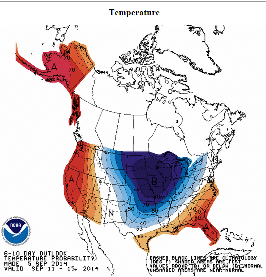
Hope to see some chatter on here this weekend about next week's cold front. Looks like we have ALL SYSTEMS GO on the front and it should be significant. Who picked around September 12th for our first major front?
0 likes
Any forecasts under my name are to be taken with a grain of salt. Get your best forecasts from the National Weather Service and National Hurricane Center.
-
Ralph's Weather
- S2K Supporter

- Posts: 3371
- Age: 38
- Joined: Fri Dec 13, 2013 11:55 am
- Location: Lindale, TX
- Contact:
Looks like late next week we will cool off to July levels  . I have not had a chance to look at the models, are we talking 75 highs 55 lows for the weekend for the I-20 corridor?
0 likes
Follow on Facebook at Ralph's Weather.
-
aggiecutter
- Category 5

- Posts: 1755
- Joined: Thu Oct 14, 2004 9:22 pm
- Location: Texarkana
Re: Texas Fall-2014
Looks like an early taste of fall on the way for the northern 3rd of the state.

0 likes

I'd pay attention to this weekend before the cold front next week. Norbert in the EPAC is almost a major hurricane (wow at that basin this year) and there is a weak front crossing through. I think moisture opportunities this week continues to look better for much of the state thanks to these features. ECMWF is dropping anywhere from 2-5 inches for a large swath, lift mechanism from fronts and tropical connection from Pacific.
Think we will see the EPAC/El Nino/Fall connection at it's best the next 3 months. Norbert is probably the first of many to come. When there is lows of some sort near the Baja is usually good for us.
Think we will see the EPAC/El Nino/Fall connection at it's best the next 3 months. Norbert is probably the first of many to come. When there is lows of some sort near the Baja is usually good for us.
0 likes
The above post and any post by Ntxw is NOT an official forecast and should not be used as such. It is just the opinion of the poster and may or may not be backed by sound meteorological data. It is NOT endorsed by any professional institution including Storm2k. For official information, please refer to NWS products.
Help support Storm2K!

Re:
Ntxw wrote:I'd pay attention to this weekend before the cold front next week. Norbert in the EPAC is almost a major hurricane (wow at that basin this year) and there is a weak front crossing through. I think moisture opportunities this week continues to look better for much of the state thanks to these features. ECMWF is dropping anywhere from 2-5 inches for a large swath, lift mechanism from fronts and tropical connection from Pacific.
Think we will see the EPAC/El Nino/Fall connection at it's best the next 3 months. Norbert is probably the first of many to come. When there is lows of some sort near the Baja is usually good for us.
I hope so, we are desperate for rain. Heard a rumor that if we stay as-is, we will be stage 5 in the spring.
0 likes
The above post and any post by dhweather is NOT an official forecast and should not be used as such. It is just the opinion of the poster and may or may not be backed by sound meteorological data. It is NOT endorsed by any professional institution including storm2k.org. For official information, please refer to NWS products.
Re: Re:
dhweather wrote:I hope so, we are desperate for rain. Heard a rumor that if we stay as-is, we will be stage 5 in the spring.
I don't think that will happen. 2011 was the apex of the decadal drought and we didn't achieve stage 5. Out west where water reserves and sources are much less could be but for a major metropolitan it's a very low chance.
0 likes
The above post and any post by Ntxw is NOT an official forecast and should not be used as such. It is just the opinion of the poster and may or may not be backed by sound meteorological data. It is NOT endorsed by any professional institution including Storm2k. For official information, please refer to NWS products.
Help support Storm2K!
Help support Storm2K!
Re: Texas Fall-2014
Here's the radar for the southern plains, front will be arriving by morning. I'm not sure on timing for rain, but half inch to an inch for spots.

0 likes
The above post and any post by Ntxw is NOT an official forecast and should not be used as such. It is just the opinion of the poster and may or may not be backed by sound meteorological data. It is NOT endorsed by any professional institution including Storm2k. For official information, please refer to NWS products.
Help support Storm2K!
Help support Storm2K!
-
Janie2006

- Category 5
- Posts: 1329
- Joined: Mon Sep 18, 2006 3:28 pm
- Location: coastal Ms aka home of the hurricanes
Re: Texas Fall-2014
Portastorm wrote:Hope to see some chatter on here this weekend about next week's cold front. Looks like we have ALL SYSTEMS GO on the front and it should be significant. Who picked around September 12th for our first major front?
I was 5 days off.
Finally, the local (relatively speaking) media is picking up on this probable first true fall front of the season. James Spann out of Birmingham has been talking about it this afternoon on the ABC 33/40 wx blog, tentatively predicting 40s for minimum temperatures in the favoured spots of northern Alabama late next week. Whilst this has little to do with Texas, it has everything to do with a strong cold front for September and there's no reason at all to think a lot of Texas won't see some nice cool air.
Indeed, it is "all systems go". Let the games begin.
0 likes
-
TheProfessor

- Professional-Met

- Posts: 3506
- Age: 29
- Joined: Tue Dec 03, 2013 10:56 am
- Location: Wichita, Kansas
Re: Texas Fall-2014
You know, by definition this is an Arctic air mass. It came from the Arctic above Alaska, the high pressure is of Arctic origin. But it's September, so the saying doesn't quite have the same meaning. We'll love it either way, relief.

So why is this happening?
This

Because of this

So why is this happening?
This
Because of this
0 likes
The above post and any post by Ntxw is NOT an official forecast and should not be used as such. It is just the opinion of the poster and may or may not be backed by sound meteorological data. It is NOT endorsed by any professional institution including Storm2k. For official information, please refer to NWS products.
Help support Storm2K!
Help support Storm2K!
-
TeamPlayersBlue

- Category 5
- Posts: 3530
- Joined: Tue Feb 02, 2010 1:44 am
- Location: Denver/Applewood, CO
Great graphics. The warm pool is still there! Im smiling from ear to ear over here. We should have more moisture to play with this year too. Im pumped. Any other times where we had a major front this early? I dont remember one this early at all. Mid October is the earliest i remember.
0 likes
Personal Forecast Disclaimer:
The posts in this forum are NOT official forecast and should not be used as such. They are just the opinion of the poster and may or may not be backed by sound meteorological data. They are NOT endorsed by any professional institution or storm2k.org. For official information, please refer to the NHC and NWS products.
The posts in this forum are NOT official forecast and should not be used as such. They are just the opinion of the poster and may or may not be backed by sound meteorological data. They are NOT endorsed by any professional institution or storm2k.org. For official information, please refer to the NHC and NWS products.
-
Portastorm
- Storm2k Moderator
- Posts: 9955
- Age: 63
- Joined: Fri Jul 11, 2003 9:16 am
- Location: Round Rock, TX
- Contact:
Re: Texas Fall-2014
Janie2006 wrote:Portastorm wrote:Hope to see some chatter on here this weekend about next week's cold front. Looks like we have ALL SYSTEMS GO on the front and it should be significant. Who picked around September 12th for our first major front?
I was 5 days off.
Finally, the local (relatively speaking) media is picking up on this probable first true fall front of the season. James Spann out of Birmingham has been talking about it this afternoon on the ABC 33/40 wx blog, tentatively predicting 40s for minimum temperatures in the favoured spots of northern Alabama late next week. Whilst this has little to do with Texas, it has everything to do with a strong cold front for September and there's no reason at all to think a lot of Texas won't see some nice cool air.
Indeed, it is "all systems go". Let the games begin.
Unless we're talking some sharp, deep trough ... our respective areas of the CONUS are indeed often interconnected weatherwise. Janie, you may have been one of the ones calling for an earlier fropa. So, you get points for that.
0 likes
Any forecasts under my name are to be taken with a grain of salt. Get your best forecasts from the National Weather Service and National Hurricane Center.
GFS has a high of 75 and low of 61 in Austin, partly to mostly cloudy, and a N/NE breeze on Friday. Talk about perfect high school football weather!
0 likes
The above post and any post by Ntxw is NOT an official forecast and should not be used as such. It is just the opinion of the poster and may or may not be backed by sound meteorological data. It is NOT endorsed by any professional institution including Storm2k. For official information, please refer to NWS products.
Help support Storm2K!
Help support Storm2K!
-
Janie2006
- Category 5
- Posts: 1329
- Joined: Mon Sep 18, 2006 3:28 pm
- Location: coastal Ms aka home of the hurricanes
I'll take any points I can get. 
Right. I've got a mug of tea, so let's get cracking. The graphic posted by Ntwx indicates that the water temperatures off the coast of British Columbia are anomalously warm, in some cases bordering on 4*C over the average, which may be even warmer than the already above-average SSTs we've seen in that part of the Pacific this summer. No changes, then. The shallow, colder air has to go somewhere, and it's going to flow into the heart of the continental US.
If it were December or January we'd be talking about a major Arctic outbreak, but since it's September and the sun angle is still rather high we're talking about moderately cool conditions rather than *cold*. Still, the idea is (1) harbinger of an early autumn and (2) this front could break the typical heat and humidity of early September, perhaps for good this season.
0 likes
12z Ecmwf is reinforcing late week front with another front following it and shower activity beginning the following week
0 likes
The above post and any post by Ntxw is NOT an official forecast and should not be used as such. It is just the opinion of the poster and may or may not be backed by sound meteorological data. It is NOT endorsed by any professional institution including Storm2k. For official information, please refer to NWS products.
Help support Storm2K!
Help support Storm2K!

-
South Texas Storms

- Professional-Met
- Posts: 4256
- Joined: Thu Jun 24, 2010 12:28 am
- Location: Houston, TX
Re: Texas Fall-2014
Rain chances will be increasing this afternoon through tomorrow as a weak cold front stalls across central Texas. Some places could receive over 1 inch of rain by Monday. A stronger cold front could move through much of Texas around the end of this week bringing more rain chances and cooler temperatures.


0 likes
-
weatherdude1108
- Category 5
- Posts: 4228
- Joined: Tue Dec 13, 2011 1:04 pm
- Location: Northwest Austin/Cedar Park, TX
Encouraging discussion from the EWX office!
"000
FXUS64 KEWX 062034
AFDEWX
AREA FORECAST DISCUSSION
NATIONAL WEATHER SERVICE AUSTIN/SAN ANTONIO TX
334 PM CDT SAT SEP 6 2014
.SHORT TERM (TODAY THROUGH SUNDAY)...
AN INTERESTING FIRST FORECAST PERIOD IS IN STORE FOR TONIGHT.
AN UPPER LEVEL LOW IS PUSHING SOUTHWEST ACROSS THE NORTHWEST GULF
WATERS WHILE A WEAK SURFACE CONVERGENCE ZONE SITS ALONG THE
COASTAL PLAINS. THE UPPER LOW WILL PROVIDE ENOUGH LIFT FOR SHOWERS
AND THUNDERSTORMS TO DEVELOP ALONG THE COASTAL PLAINS LATE THIS
AFTERNOON AND EVENING WHILE SLOWLY MOVING TO THE NORTHWEST.
SOME OF THESE STORMS ARE EXPECTED TO PRODUCE HEAVY RAIN AND WIND
GUSTS UP TO 40 MPH. THE WEAK CONVERGENCE ZONE WILL REMAIN TONIGHT
OVER THE AREA WITH DEW POINTS IN THE LOWER 70S AND PWATS NEAR 2
INCH.
LATER TONIGHT...A COLD FRONT OVER NORTH TEXAS IS EXPECTED TO
MOVE INTO THE HILL COUNTRY AND BRING AN ADDITIONAL FOCUS FOR RAIN
LATE THIS EVENING INTO THE OVERNIGHT HOURS. THE COLD FRONT...AS
WELL AS ASSOCIATED OUTFLOW BOUNDARIES FROM CONVECTION...IS EXPECTED
TO PRODUCE HEAVY RAIN AND POSSIBLE LOCALIZED FLOODING. THESE AREAS
ARE GENERALLY NORTH OF A LINE FROM DEL RIO TO SEGUIN TO LEXINGTON.
THE REASONING OF POSSIBLE LOCALIZED FLOODING IS DUE TO SLOW MOVING
STORM MOTION/STEERING FLOW WHICH COULD RESULT IN RAINFALL AMOUNTS
OF 1 TO 3 INCHES WITH UP TO 5 INCHES POSSIBLE. THE TIMING IS FROM
ABOUT 7 PM TO 4 AM SUNDAY MORNING. BY SUNDAY MORNING...THE COLD
FRONT SHOULD BE EXITING OUR SOUTHERN COUNTIES WITH ISOLATED
SHOWERS AND THUNDERSTORMS LINGERING IN THE WAKE OF THE FRONT
MAINLY ALONG INTERSTATE 35 AND EASTERN COUNTIES.
&&
.LONG TERM (SUNDAY NIGHT THROUGH FRIDAY)...
WEATHER CONDITIONS SHOULD REMAIN RELATIVELY DRY FOR MUCH OF NEXT
WEEK WITH ONLY SEA-BREEZE CONVECTION AFFECTING THE COASTAL PLAINS
AND PARTS OF THE SOUTHEASTERN COUNTIES MAINLY DURING THE AFTERNOONS.
A SECOND COLD FRONT IS EXPECTED TO DROP DOWN TO OUR AREA LATE
THURSDAY INTO FRIDAY. GREATEST RAIN CHANCES FROM THIS FRONT ARE
EXPECTED OVER THE HILL COUNTY/EDWARDS PLATEAU AREA AS OF THIS
PACKAGE. COOLER TEMPERATURES ARE ANTICIPATED IN THE WAKE OF THE
FRONT WITH HIGHS IN THE MID 80S AND LOWER 90S ON FRIDAY AND
SATURDAY AND LOWS IN THE LOWER 60S OVER THE HILL COUNTRY AND LOWER
70S ELSEWHERE."
0 likes
The preceding post is NOT an official forecast, and should not be used as such. It is only the opinion of the poster and may or may not be backed by sound meteorological data. It is NOT endorsed by any professional institution including storm2k.org. For Official Information please refer to the NHC and NWS products.
-
Rgv20

- S2K Supporter
- Posts: 2466
- Age: 39
- Joined: Wed Jan 05, 2011 5:42 pm
- Location: Edinburg/McAllen Tx
NWS Brownsville afternoon discussion regarding Rain chances for late next week until the weekend....Cold Front+Tropical Moisture=Good for Rain!!
IT LOOKS LIKE THINGS MAY BE CHANGING FAIRLY
SIGNIFICANTLY FRIDAY AND SATURDAY. FIRST...A LARGE UPPER LEVEL
TROUGH WILL DIG SOUTH INTO THE CENTRAL PLAINS WED AND THURSDAY
AND GENERATE A POTENT COLD FRONT THE WILL SURGE SOUTH AND INTO
TEXAS THU OR FRIDAY. THE GFS IS DEFINITELY MORE BULLISH THAN THE
EURO...BUT BOTH MODELS HAVE THE FRONT IN THE VICINITY OF DEEP
SOUTH TEXAS FRIDAY NIGHT AND SATURDAY. IN ADDITION...TROPICAL
MOISTURE IS EXPECTED TO STREAM NORTHWARD AND INTERACT WITH THE
FRONT WHICH IS LOOKING MORE PROMISING FOR THE POSSIBILITY OF
WIDESPREAD BENEFICIAL RAINS WHICH COULD LAST THROUGH SUNDAY.
LITTLE OR NO TEMPERATURE IMPACTS ARE ANTICIPATED DUE TO THE
FRONTAL SYSTEM DIRECTLY...BUT OVERCAST SKIES AND RAINFALL SHOULD
ACT TO KEEP HIGH TEMPS A FEW DEGREES BELOW NORMAL FOR THE WEEKEND.
THIS SCENARIO REMAINS MANY DAYS AWAY...BUT MODELS HAVE BEEN FAIRLY
CONSISTENT WITH THIS SCENARIO OVER THE PAST COUPLE OF DAYS.
AS A RESULT...MAX TEMPS WERE ADJUSTED DOWN A COUPLE OF DEGREES
FRIDAY AND SATURDAY. IF THE TREND CONTINUES...FURTHER DOWNWARD
ADJUSTMENTS TO DAYTIME TEMPS MAY BE WARRANTED.
OTHERWISE...INHERITED TEMPS WERE MAINTAINED. ADJUSTED POPS FOR
THE FRIDAY AND SATURDAY PERIODS AS WELL. INCLUDED WIDESPREAD 30
PERCENT POPS FOR NOW...BUT IF CURRENT TRENDS CONTINUE...FURTHER
UPWARD ADJUSTMENT TO POPS WILL BE NEEDED.
0 likes
The following post is NOT an official forecast and should not be used as such. It is just the opinion of the poster and may or may not be backed by sound meteorological data. It is NOT endorsed by any professional institution including storm2k.org For Official Information please refer to the NHC and NWS products.
-
gboudx

- S2K Supporter
- Posts: 4090
- Joined: Thu Sep 04, 2003 1:39 pm
- Location: Rockwall, Tx but from Harvey, La
Steve McCauley teasing about what lies after next weekends cold front:
"Our cold front is on schedule to arrive by Thursday bringing showers and storms through Friday to at least half of north Texas along with brisk north winds with temperature struggling to get out of the 70s on Friday and Saturday!
And if that isn't cool enough for you, just wait until the following week."
0 likes
Return to “USA & Caribbean Weather”
Who is online
Users browsing this forum: CaptinCrunch and 107 guests