Texas Spring 2019

U.S. & Caribbean Weather Discussions and Severe Weather Events

Moderator: S2k Moderators

Forum rules

The posts in this forum are NOT official forecast and should not be used as such. They are just the opinion of the poster and may or may not be backed by sound meteorological data. They are NOT endorsed by any professional institution or STORM2K.

Help Support Storm2K
Message
Author
User avatar
bubba hotep
S2K Supporter
S2K Supporter
Posts: 5837
Joined: Wed Dec 28, 2016 1:00 am
Location: Collin County Texas

Re: Texas Spring 2019

#801 Postby bubba hotep » Wed Apr 17, 2019 5:23 pm

Ntxw wrote:
bubba hotep wrote:
Ntxw wrote:
Maybe it will end up as a social media severe outbreak...

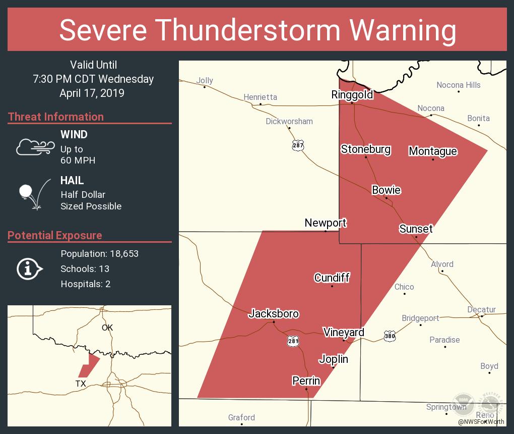
I'm a little surprised given it is an enhanced risk day rather than a moderate or high risk day that it is spreading wildly without context.


SPC, NWS and local mets all used language yesterday that seemed to indicate that an upgrade to MOD for hail today was possible. Then the overnight models introduced some uncertainty with convective evolution today. Nearly all the CAMs showed early convection with the 1st disturbance and that obviously didn't happen. I think we are now back to what was expected yesterday with a high likelihood that big hail producers firing off the dryline. As of right now, there are two obvious areas of low level convergence that could fire storms with one just west of DFW and the other out on the dryline bulge. I wouldn't relax just yet.


The best upper forcing dynamics is in the Panhandle moving E/NE. Thats the thing when dealing with a CAP down this way. High bust potential some days. I still think a quickly forming line/MCS clipping the southern half of north texas late evening likely is probable scenario.


Some obvious signs of subsidence on sat behind the departing disturbance but CAPE is pushing 4k across portions of western DFW. It won't take much to fire things off. The 18z DFW sounding showed both some cap and subsidence but not bullet proof. I'm not sure this ends up as a cap bust but maybe so.
0 likes   
Winter time post are almost exclusively focused on the DFW area.

gpsnowman
S2K Supporter
S2K Supporter
Posts: 3186
Joined: Fri Jan 07, 2011 10:35 am
Location: Grand Prairie Tx

Re: Texas Spring 2019

#802 Postby gpsnowman » Wed Apr 17, 2019 5:30 pm

High altitude cloud tops are visible from my balcony looking north. Maybe the cap is weakening? Not a darn thing on radar yet from DFW west.
1 likes   

rwfromkansas
Category 5
Category 5
Posts: 2627
Joined: Sat Aug 27, 2005 12:47 am
Location: North Fort Worth

Re: Texas Spring 2019

#803 Postby rwfromkansas » Wed Apr 17, 2019 5:45 pm

There is a thin line of some forcing or something around Weatherford on radar. No storms though.
0 likes   

User avatar
bubba hotep
S2K Supporter
S2K Supporter
Posts: 5837
Joined: Wed Dec 28, 2016 1:00 am
Location: Collin County Texas

Re: Texas Spring 2019

#804 Postby bubba hotep » Wed Apr 17, 2019 5:55 pm

Updrafts are really starting to get that crisp look with fat heavy bases underneath, it won't be long.
0 likes   
Winter time post are almost exclusively focused on the DFW area.

TarrantWx
Category 1
Category 1
Posts: 287
Age: 39
Joined: Thu Jan 30, 2014 10:38 am
Location: Keller, TX

Re: Texas Spring 2019

#805 Postby TarrantWx » Wed Apr 17, 2019 5:58 pm

Echoes showing up on radar in Jack and Montague counties. That fits with what the HRRR was showing with initiation NW of DFW.
0 likes   

User avatar
Quixotic
Category 2
Category 2
Posts: 729
Joined: Tue Feb 14, 2017 12:27 am
Location: Frisco

Re: Texas Spring 2019

#806 Postby Quixotic » Wed Apr 17, 2019 6:05 pm

I see towers forming off to the west. I'm in eastern Denton county.
1 likes   

User avatar
Quixotic
Category 2
Category 2
Posts: 729
Joined: Tue Feb 14, 2017 12:27 am
Location: Frisco

Re: Texas Spring 2019

#807 Postby Quixotic » Wed Apr 17, 2019 6:10 pm

My bad if someone posted this but I didn't see it in the last few posts:

https://www.spc.noaa.gov/products/md/md0373.html
1 likes   

User avatar
bubba hotep
S2K Supporter
S2K Supporter
Posts: 5837
Joined: Wed Dec 28, 2016 1:00 am
Location: Collin County Texas

Re: Texas Spring 2019

#808 Postby bubba hotep » Wed Apr 17, 2019 6:10 pm

Image


Mesoscale Discussion 0373
NWS Storm Prediction Center Norman OK
0554 PM CDT Wed Apr 17 2019

Areas affected...south-central OK into northern and central TX

Concerning...Severe potential...Watch likely

Valid 172254Z - 180100Z

Probability of Watch Issuance...80 percent

SUMMARY...Convection will likely develop in the next 1-2 hours and
watch will likely be needed by 00z. A localized tornado threat may
develop in the vicinity of the Red River from north Texas into
south-central OK in the short term with additional severe convection
expected later this evening into central TX.

DISCUSSION...Latest visible satellite imagery shows an increasingly
agitated cu field across the Red River Valley into north TX along a
sharp dryline extending southward from a surface low near CDS, and
to the south of a warm front oriented west to east across
south-central OK. Latest water vapor imagery also shows some deeper
updrafts beginning to develop in the vicinity of Jack, Montague,
Cooke, Wise and Denton Counties in north Texas. Furthermore, the
increase of midlevel clouds further southwest across the Trans-Pecos
and Permia Basin regions of western TX indicate that stronger
forcing is now beginning to shift eastward into the region. This
should support convective initiation in the next couple of hours
across the MCD area.

In the short term, should isolated cells develop in the vicinity of
the triple point in the Red River Valley, supercells capable of very
large hail, damaging winds and tornadoes will be possible. While low
level flow isn't particularly strong across this region, the warm
front will enhance low level SRH. Mean mixing ratios between 12-14
g/kg also will be more than sufficient for tornado production.
Additionally, midlevel lapse rates between 8-9 C/km as sampled by
the 20z OUN RAOB and 0-6 km shear greater than 45 kt will favor very
large hail.

Eventually, as forcing for ascent increases and the surface cold
front begins to catch up to the dryline, additional, vigorous
convection is expected to develop southward into central Texas this
evening. This convection may initially pose a threat for very large
hail before growing upscale into bowing line segments and
transitioning to a damaging wind threat.

..Leitman/Hart.. 04/17/2019

...Please see http://www.spc.noaa.gov for graphic product...

ATTN...WFO...FWD...OUN...SJT...
1 likes   
Winter time post are almost exclusively focused on the DFW area.

User avatar
CaptinCrunch
S2K Supporter
S2K Supporter
Posts: 8728
Age: 57
Joined: Mon Nov 03, 2003 4:33 pm
Location: Kennedale, TX (Tarrant Co.)

Re: Texas Spring 2019

#809 Postby CaptinCrunch » Wed Apr 17, 2019 6:18 pm

Severe Thunderstorm Watch for NTX just issued. Right on time :wink:
0 likes   

rwfromkansas
Category 5
Category 5
Posts: 2627
Joined: Sat Aug 27, 2005 12:47 am
Location: North Fort Worth

Re: Texas Spring 2019

#810 Postby rwfromkansas » Wed Apr 17, 2019 6:19 pm

I wonder what that boundary west of Tarrant county is...it’s moving west, which is odd.
0 likes   

User avatar
Quixotic
Category 2
Category 2
Posts: 729
Joined: Tue Feb 14, 2017 12:27 am
Location: Frisco

Re: Texas Spring 2019

#811 Postby Quixotic » Wed Apr 17, 2019 6:28 pm

rwfromkansas wrote:I wonder what that boundary west of Tarrant county is...it’s moving west, which is odd.


not really. as the air cools as the sun goes down, it has a tendency to shrink back west.
1 likes   

HockeyTx82
S2K Supporter
S2K Supporter
Posts: 2540
Joined: Tue Oct 27, 2009 11:17 am
Location: Ponder, TX

Re: Texas Spring 2019

#812 Postby HockeyTx82 » Wed Apr 17, 2019 6:35 pm

Any chance the rain and clouds we had around the Denton area maybe stabilized things a little bit so we don't get the big stuff now. More a wind hail line threat later on?
0 likes   
Don't hold me accountable for anything I post on this forum. Leave the real forecasting up to the professionals.

Location: Ponder, TX (all observation posts are this location unless otherwise noted)

User avatar
bubba hotep
S2K Supporter
S2K Supporter
Posts: 5837
Joined: Wed Dec 28, 2016 1:00 am
Location: Collin County Texas

Re: Texas Spring 2019

#813 Postby bubba hotep » Wed Apr 17, 2019 6:36 pm

Image

Image
0 likes   
Winter time post are almost exclusively focused on the DFW area.

HockeyTx82
S2K Supporter
S2K Supporter
Posts: 2540
Joined: Tue Oct 27, 2009 11:17 am
Location: Ponder, TX

Re: Texas Spring 2019

#814 Postby HockeyTx82 » Wed Apr 17, 2019 6:40 pm

Any chance those do right turn and head due east? Or more of a NE track?
0 likes   
Don't hold me accountable for anything I post on this forum. Leave the real forecasting up to the professionals.

Location: Ponder, TX (all observation posts are this location unless otherwise noted)

User avatar
bubba hotep
S2K Supporter
S2K Supporter
Posts: 5837
Joined: Wed Dec 28, 2016 1:00 am
Location: Collin County Texas

Re: Texas Spring 2019

#815 Postby bubba hotep » Wed Apr 17, 2019 6:44 pm

Pretty rapid development SW of DFW as well. Those would be the ones to watch given the current storm motion, given they are far enough away to fully mature before reaching DFW.
1 likes   
Winter time post are almost exclusively focused on the DFW area.

User avatar
bubba hotep
S2K Supporter
S2K Supporter
Posts: 5837
Joined: Wed Dec 28, 2016 1:00 am
Location: Collin County Texas

Re: Texas Spring 2019

#816 Postby bubba hotep » Wed Apr 17, 2019 6:48 pm

From initiation to svr warned was a pretty short trip

Image
0 likes   
Winter time post are almost exclusively focused on the DFW area.

User avatar
Ntxw
Storm2k Moderator
Storm2k Moderator
Posts: 22786
Joined: Wed Oct 21, 2009 6:34 pm
Location: DFW, Texas

Re: Texas Spring 2019

#817 Postby Ntxw » Wed Apr 17, 2019 6:48 pm

The models are advertising a slow moving trough next week. I think that will be a good shot at significant heavy rains across the state. The recent SOI crash is a good indicator of a slow moving SW-SC trough.
1 likes   
The above post and any post by Ntxw is NOT an official forecast and should not be used as such. It is just the opinion of the poster and may or may not be backed by sound meteorological data. It is NOT endorsed by any professional institution including Storm2k. For official information, please refer to NWS products.

  Help support Storm2K!
Help Support Storm2K

User avatar
bubba hotep
S2K Supporter
S2K Supporter
Posts: 5837
Joined: Wed Dec 28, 2016 1:00 am
Location: Collin County Texas

Re: Texas Spring 2019

#818 Postby bubba hotep » Wed Apr 17, 2019 7:01 pm

The cell SW of DFW has gone warned

Image
0 likes   
Winter time post are almost exclusively focused on the DFW area.

User avatar
bubba hotep
S2K Supporter
S2K Supporter
Posts: 5837
Joined: Wed Dec 28, 2016 1:00 am
Location: Collin County Texas

Re: Texas Spring 2019

#819 Postby bubba hotep » Wed Apr 17, 2019 7:23 pm

Another watch out

Image
1 likes   
Winter time post are almost exclusively focused on the DFW area.

User avatar
bubba hotep
S2K Supporter
S2K Supporter
Posts: 5837
Joined: Wed Dec 28, 2016 1:00 am
Location: Collin County Texas

Re: Texas Spring 2019

#820 Postby bubba hotep » Wed Apr 17, 2019 7:41 pm

Image
1 likes   
Winter time post are almost exclusively focused on the DFW area.


Return to “USA & Caribbean Weather”

Who is online

Users browsing this forum: Cpv17 and 19 guests