For a couple of days, at least?
Texas Spring 2020
Moderator: S2k Moderators
Forum rules

The posts in this forum are NOT official forecast and should not be used as such. They are just the opinion of the poster and may or may not be backed by sound meteorological data. They are NOT endorsed by any professional institution or STORM2K.
-
Texas Snowman

- Storm2k Moderator

- Posts: 6197
- Joined: Fri Jan 25, 2008 11:29 am
- Location: Denison, Texas
Re: Texas Spring 2020
At the risk of sounding a little like Wxman57 here, is everyone between the Red River and the Rio Grande happy with the rainfall in their backyard?
For a couple of days, at least?
For a couple of days, at least?
3 likes
The above post and any post by Texas Snowman is NOT an official forecast and should not be used as such. It is just the opinion of the poster and may or may not be backed by sound meteorological data. It is NOT endorsed by any professional institution including storm2k.org. For official information, please refer to NWS products.
-
bubba hotep

- S2K Supporter

- Posts: 6014
- Joined: Wed Dec 28, 2016 1:00 am
- Location: Collin County Texas
Re: Texas Spring 2020
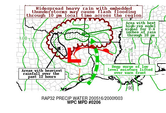
Mesoscale Precipitation Discussion 0206
NWS Weather Prediction Center College Park MD
611 PM EDT Sat May 16 2020
Areas affected...Northeast TX...Southeast OK...Northwest
LA...South central AR
Concerning...Heavy rainfall...Flash flooding possible
Valid 162210Z - 170300Z
SUMMARY...Widespread heavy rain with numerous thunderstorms will
continue into the evening hours across the ArkLaTex region in
association with a slow moving low. Flash flooding will be
possible with rainfall rates up to 2 inches per hour or even
greater, especially with training convection.
DISCUSSION...A well developed and vertically stacked low-mid level
low along with a remnant MCV is present in both radar and
satellite imagery this afternoon. A deep surge of moisture from
the western Gulf of Mexico is being lifted over an effective
surface front across northeast Texas and northwest Louisiana.
With PWs in the 1.7 to 2.0 inch range based on the latest SPC
mesoanalysis, and low LCLs, these storms should be efficient heavy
rainfall producers with a deep warm cloud layer.
The latest suite of high-res guidance is supporting the potential
of 2 to 4 inches of rainfall, and locally higher, through 2Z (9 pm
CDT) where these storms persist the longest. Areas with the best
high-res model signal for concentrated heavy rainfall is depicted
on the graphic, and thus considered more prone to flooding. Those
areas that were hammered with heavy rain earlier in the day should
avoid most of the heavier storms this evening, but it will not
take as much additional rain to cause additional flooding issues
there.
Hamrick
ATTN...WFO...FWD...JAN...LZK...OUN...SHV...TSA...
ATTN...RFC...ABRFC...LMRFC...WGRFC...NWC...
0 likes
Winter time post are almost exclusively focused on the DFW area.
-
HockeyTx82
- S2K Supporter
- Posts: 2791
- Joined: Tue Oct 27, 2009 11:17 am
- Location: Ponder, TX
Re: Texas Spring 2020
bubba hotep wrote:https://pbs.twimg.com/media/EYLAfRRVAAAe9eW?format=jpg&name=small
Mesoscale Precipitation Discussion 0206
NWS Weather Prediction Center College Park MD
611 PM EDT Sat May 16 2020
Areas affected...Northeast TX...Southeast OK...Northwest
LA...South central AR
Concerning...Heavy rainfall...Flash flooding possible
Valid 162210Z - 170300Z
SUMMARY...Widespread heavy rain with numerous thunderstorms will
continue into the evening hours across the ArkLaTex region in
association with a slow moving low. Flash flooding will be
possible with rainfall rates up to 2 inches per hour or even
greater, especially with training convection.
DISCUSSION...A well developed and vertically stacked low-mid level
low along with a remnant MCV is present in both radar and
satellite imagery this afternoon. A deep surge of moisture from
the western Gulf of Mexico is being lifted over an effective
surface front across northeast Texas and northwest Louisiana.
With PWs in the 1.7 to 2.0 inch range based on the latest SPC
mesoanalysis, and low LCLs, these storms should be efficient heavy
rainfall producers with a deep warm cloud layer.
The latest suite of high-res guidance is supporting the potential
of 2 to 4 inches of rainfall, and locally higher, through 2Z (9 pm
CDT) where these storms persist the longest. Areas with the best
high-res model signal for concentrated heavy rainfall is depicted
on the graphic, and thus considered more prone to flooding. Those
areas that were hammered with heavy rain earlier in the day should
avoid most of the heavier storms this evening, but it will not
take as much additional rain to cause additional flooding issues
there.
Hamrick
ATTN...WFO...FWD...JAN...LZK...OUN...SHV...TSA...
ATTN...RFC...ABRFC...LMRFC...WGRFC...NWC...
I can attest to the fact that Denton County, at least here in Ponder is water logged.
2 likes
Don't hold me accountable for anything I post on this forum. Leave the real forecasting up to the professionals.
Location: Ponder, TX (all observation posts are this location unless otherwise noted)
Location: Ponder, TX (all observation posts are this location unless otherwise noted)
-
bubba hotep
- S2K Supporter
- Posts: 6014
- Joined: Wed Dec 28, 2016 1:00 am
- Location: Collin County Texas
Re: Texas Spring 2020
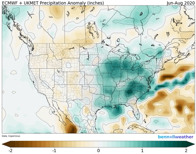
Officially 3.57" at DFW putting us +2.13 for the Month, +4.22 for Spring, and +8.31 for the Year. There are some dry concerns with the potential shift to +ENSO but I lean towards the overall background warmth in the Pacific is currently overwhelming the ENSO signal. Here is the latest blend of Euro and UKMet seasonal models for the Summer showing above normal rainfall continuing for Texas.
4 likes
Winter time post are almost exclusively focused on the DFW area.
-
bubba hotep
- S2K Supporter
- Posts: 6014
- Joined: Wed Dec 28, 2016 1:00 am
- Location: Collin County Texas

Re: Texas Spring 2020
bubba hotep wrote:Officially 3.57" at DFW putting us +2.13 for the Month, +4.22 for Spring, and +8.31 for the Year. There are some dry concerns with the potential shift to +ENSO but I lean towards the overall background warmth in the Pacific is currently overwhelming the ENSO signal. Here is the latest blend of Euro and UKMet seasonal models for the Summer showing above normal rainfall continuing for Texas.
https://pbs.twimg.com/media/EYDRKB2UYAA-cIJ?format=jpg&name=small
Why does it always rain so much in the Carolinas during the summer?
0 likes

Re: Texas Spring 2020
Cpv17 wrote:bubba hotep wrote:Officially 3.57" at DFW putting us +2.13 for the Month, +4.22 for Spring, and +8.31 for the Year. There are some dry concerns with the potential shift to +ENSO but I lean towards the overall background warmth in the Pacific is currently overwhelming the ENSO signal. Here is the latest blend of Euro and UKMet seasonal models for the Summer showing above normal rainfall continuing for Texas.
https://pbs.twimg.com/media/EYDRKB2UYAA-cIJ?format=jpg&name=small
Why does it always rain so much in the Carolinas during the summer?
Bermuda high over the western Atlantic. Rich moisture coming in from the open Atlantic Ocean.
0 likes
The above post and any post by Ntxw is NOT an official forecast and should not be used as such. It is just the opinion of the poster and may or may not be backed by sound meteorological data. It is NOT endorsed by any professional institution including Storm2k. For official information, please refer to NWS products.
Help support Storm2K!
-
Haris

- Category 5

- Posts: 1814
- Joined: Mon Nov 27, 2017 8:19 pm
- Location: ( Bee Cave) West Austin, Texas
Re: Texas Spring 2020
5.2” at Austin officially last week brings us to 17” this year which is 6” above average.
Looks like the pattern turns wet in a few days. Euro eps showing another 2” by the weekend. Could push towards 7” this month for the 2nd time in a row .
Looks like the pattern turns wet in a few days. Euro eps showing another 2” by the weekend. Could push towards 7” this month for the 2nd time in a row .
3 likes
Weather geek and a storm spotter in West Austin. Not a degreed meteorologist. Big snow fan. Love rain and cold! Despise heat!
-
Haris
- Category 5
- Posts: 1814
- Joined: Mon Nov 27, 2017 8:19 pm
- Location: ( Bee Cave) West Austin, Texas
Re: Texas Spring 2020
New euro remains amazing. Stalling low bringing rain Thurs - next Wed. Maybe even beyond.
GEFS on board too. 2-4" + !
GEFS on board too. 2-4" + !
4 likes
Weather geek and a storm spotter in West Austin. Not a degreed meteorologist. Big snow fan. Love rain and cold! Despise heat!
-
South Texas Storms

- Professional-Met

- Posts: 4256
- Joined: Thu Jun 24, 2010 12:28 am
- Location: Houston, TX
Re: Texas Spring 2020
Haris wrote:New euro remains amazing. Stalling low bringing rain Thurs - next Wed. Maybe even beyond.
GEFS on board too. 2-4" + !
Bring it on! It's too hot out there today.
2 likes
-
bubba hotep
- S2K Supporter
- Posts: 6014
- Joined: Wed Dec 28, 2016 1:00 am
- Location: Collin County Texas
Re: Texas Spring 2020
Haris wrote:New euro remains amazing. Stalling low bringing rain Thurs - next Wed. Maybe even beyond.
GEFS on board too. 2-4" + !
Widespread rains for Texas!

3 likes
Winter time post are almost exclusively focused on the DFW area.
-
bubba hotep
- S2K Supporter
- Posts: 6014
- Joined: Wed Dec 28, 2016 1:00 am
- Location: Collin County Texas
Re: Texas Spring 2020
EPS looks good as well, esp. for deep S. TX

3 likes
Winter time post are almost exclusively focused on the DFW area.
-
weatherdude1108
- Category 5
- Posts: 4228
- Joined: Tue Dec 13, 2011 1:04 pm
- Location: Northwest Austin/Cedar Park, TX
Re: Texas Spring 2020
Looking nice the next couple weeks for Texas!


3 likes
The preceding post is NOT an official forecast, and should not be used as such. It is only the opinion of the poster and may or may not be backed by sound meteorological data. It is NOT endorsed by any professional institution including storm2k.org. For Official Information please refer to the NHC and NWS products.
Re: Texas Spring 2020
bubba hotep wrote:Haris wrote:New euro remains amazing. Stalling low bringing rain Thurs - next Wed. Maybe even beyond.
GEFS on board too. 2-4" + !
Widespread rains for Texas!
https://images.weatherbell.com/model/ecmwf-deterministic/scentus/total_precip_inch/1589803200/1590667200-dkESgJv4nQE.png
I'm going to hug that 2007 analog all summer! Low solar, Nino -> Nina, IO. A lot of similarities. Weakness over the S Plains.
4 likes
The above post and any post by Ntxw is NOT an official forecast and should not be used as such. It is just the opinion of the poster and may or may not be backed by sound meteorological data. It is NOT endorsed by any professional institution including Storm2k. For official information, please refer to NWS products.
Help support Storm2K!
Help support Storm2K!
-
TheProfessor

- Professional-Met
- Posts: 3506
- Age: 29
- Joined: Tue Dec 03, 2013 10:56 am
- Location: Wichita, Kansas
Re: Texas Spring 2020
bubba hotep wrote:EPS looks good as well, esp. for deep S. TX
https://images.weatherbell.com/model/ecmwf-ensemble-avg/scentus/total_precip_inch/1589803200/1591099200-qEny6PJWXKM.png
The EPS would certainly be good for portions of the Gulf Coast that still need rain, but definitely not good for those of us that got dumped on. It's definitely a dilemma because it's hard to wish against it knowing that others nearby still need it.
2 likes
An alumnus of The Ohio State University.
Your local National Weather Service office is your best source for weather information.
Your local National Weather Service office is your best source for weather information.
-
TeamPlayersBlue

- Category 5
- Posts: 3530
- Joined: Tue Feb 02, 2010 1:44 am
- Location: Denver/Applewood, CO
Re: Texas Spring 2020
bubba hotep wrote:EPS looks good as well, esp. for deep S. TX
https://images.weatherbell.com/model/ecmwf-ensemble-avg/scentus/total_precip_inch/1589803200/1591099200-qEny6PJWXKM.png
360 hrs out cant be trusted!
0 likes
Personal Forecast Disclaimer:
The posts in this forum are NOT official forecast and should not be used as such. They are just the opinion of the poster and may or may not be backed by sound meteorological data. They are NOT endorsed by any professional institution or storm2k.org. For official information, please refer to the NHC and NWS products.
The posts in this forum are NOT official forecast and should not be used as such. They are just the opinion of the poster and may or may not be backed by sound meteorological data. They are NOT endorsed by any professional institution or storm2k.org. For official information, please refer to the NHC and NWS products.
-
rwfromkansas
- Category 5
- Posts: 3032
- Joined: Sat Aug 27, 2005 12:47 am
- Location: North Fort Worth
-
weatherdude1108
- Category 5
- Posts: 4228
- Joined: Tue Dec 13, 2011 1:04 pm
- Location: Northwest Austin/Cedar Park, TX
Re: Texas Spring 2020
Area Forecast Discussion
National Weather Service Austin/San Antonio TX
313 AM CDT Tue May 19 2020
.SHORT TERM (Today through Wednesday)...
High pressure still dominating the region causing this hot and dry
weather. Today, the heat is on with highs reaching upper 90s across
the I-35 corridor with the Rio Grande Plains a few degrees above
100. These high temps leave the relative humidity values in the
upper teens and low 20s in our far west, increasing the fire weather
threat. Winds remain relatively light and out of the south.
Wednesday is almost a carbon copy of today with very warm
temperatures and mostly clear skies, with the exception of early
morning cloud cover that should mix out by mid morning.
&&
.LONG TERM (Wednesday Night through Monday)...
There is a small potential that some storms could develop west of the
Rio Grande Wednesday afternoon and move into the western counties
Wednesday evening. The GFS remains the only model to really show this
solution, but it has been consistent for many days. However, we are
now getting into the shorter range of some of the high-res models and
the NAM/TTU WRF all support the dry ECWMF solution. Will keep PoPs
capped at 20 percent.
A better chance of showers and thunderstorms arrives Thursday for the
area as a weak shortwave embedded in zonal flow moves near the
region. Elevated rain chances will continue into the weekend and into
Monday. Models are fairly consistent that a trough will move into the
region by the weekend with the potential of the low becoming cutoff
somewhere near the Southern Plains by Monday. Leading up to that,
several rounds of scattered rainfall will be possible over the
weekend as energy from the nearly stationary trough spark afternoon
and evening convection. In addition, there is some potential of a
cold front arriving around Monday which could lead to a further
increase in rain chances. Peeking ahead into the day 7-10 range has
decent agreement between the GFS and ECMWF of the cut off low not
really moving as the upper pattern shows not one but two omega blocks
across the CONUS. A lot of the details on what exactly will happen
this weekend into next week are up in the air and will depend on the
exact positioning of the trough and possible cut off low as run-to-
run shifts have big effects on forecasted rain amounts. Nevertheless,
rain chances will remain elevated this Memorial Day weekend with
some potential for heavy rainfall.
1 likes
The preceding post is NOT an official forecast, and should not be used as such. It is only the opinion of the poster and may or may not be backed by sound meteorological data. It is NOT endorsed by any professional institution including storm2k.org. For Official Information please refer to the NHC and NWS products.
-
jasons2k

- Storm2k Executive

- Posts: 8290
- Age: 52
- Joined: Wed Jul 06, 2005 12:32 pm
- Location: The Woodlands, TX
Re: Texas Spring 2020
Here is an update from Jeff Lindner:
Near record highs likely today across the region.
Upper level high pressure continues to build over the area and this will result in near record or record heat this afternoon. Expect high temperatures to reach the mid and upper 90’s over much of the area. Humidity values still remain fairly low by SE TX standards, so heat index values will be close to the actual air temperature. Southerly winds increase in Wednesday and allow greater humidity values to move into the region. This will support heat index values of 98-102 during the afternoon hours through Thursday
Late Week/Weekend:
Deep tropical moisture gathering over the western Caribbean Sea will begin to track toward the TX coast by Thursday into Friday. While aloft over TX, the strong ridge of high pressure breaks down allowing the formation of another slow moving upper level low. Periods of showers and thunderstorms will return as early as Friday and increase over the weekend and into next week with deep moisture in place and a blocky upper air pattern aloft keeping storm systems from moving eastward. I am a bit leary of the rainfall potential after last week, when global models forecasted a similar setup and the upper level trough became more progressive over time. This time around, however the pattern looks much slower with a stalling upper level system. Still lots of time to work out the details on greatest rain chances and amounts.
0 likes
Re: Texas Spring 2020
rwfromkansas wrote:No Nina please. Lol.
A delayed spring like we just had (and in 2007) the broad pattern can actually be beneficial in early Summer! It can shorten the span that the stagnant summer regime setting in.
The caveat is in the Fall and the following year which we all know ensued the multiyear drought. No guarantee it will play out this way. I think we are heading into a late Nina but the broad Pacific is mixed. The PDO will determine our fate if it strings together months of being negative, then we know we are in trouble. 2020 as a whole will be alright regarding rainfall/lakes.
4 likes
The above post and any post by Ntxw is NOT an official forecast and should not be used as such. It is just the opinion of the poster and may or may not be backed by sound meteorological data. It is NOT endorsed by any professional institution including Storm2k. For official information, please refer to NWS products.
Help support Storm2K!
Help support Storm2K!
Return to “USA & Caribbean Weather”
Who is online
Users browsing this forum: CaptinCrunch, HurricaneBelle, Stratton23 and 52 guests