Florida Weather

U.S. & Caribbean Weather Discussions and Severe Weather Events

Moderator: S2k Moderators

Forum rules

The posts in this forum are NOT official forecast and should not be used as such. They are just the opinion of the poster and may or may not be backed by sound meteorological data. They are NOT endorsed by any professional institution or STORM2K.

Help Support Storm2K
Message
Author
User avatar
northjaxpro
S2K Supporter
S2K Supporter
Posts: 8900
Joined: Mon Sep 27, 2010 11:21 am
Location: Jacksonville, FL

#8521 Postby northjaxpro » Sat Sep 27, 2014 9:45 am

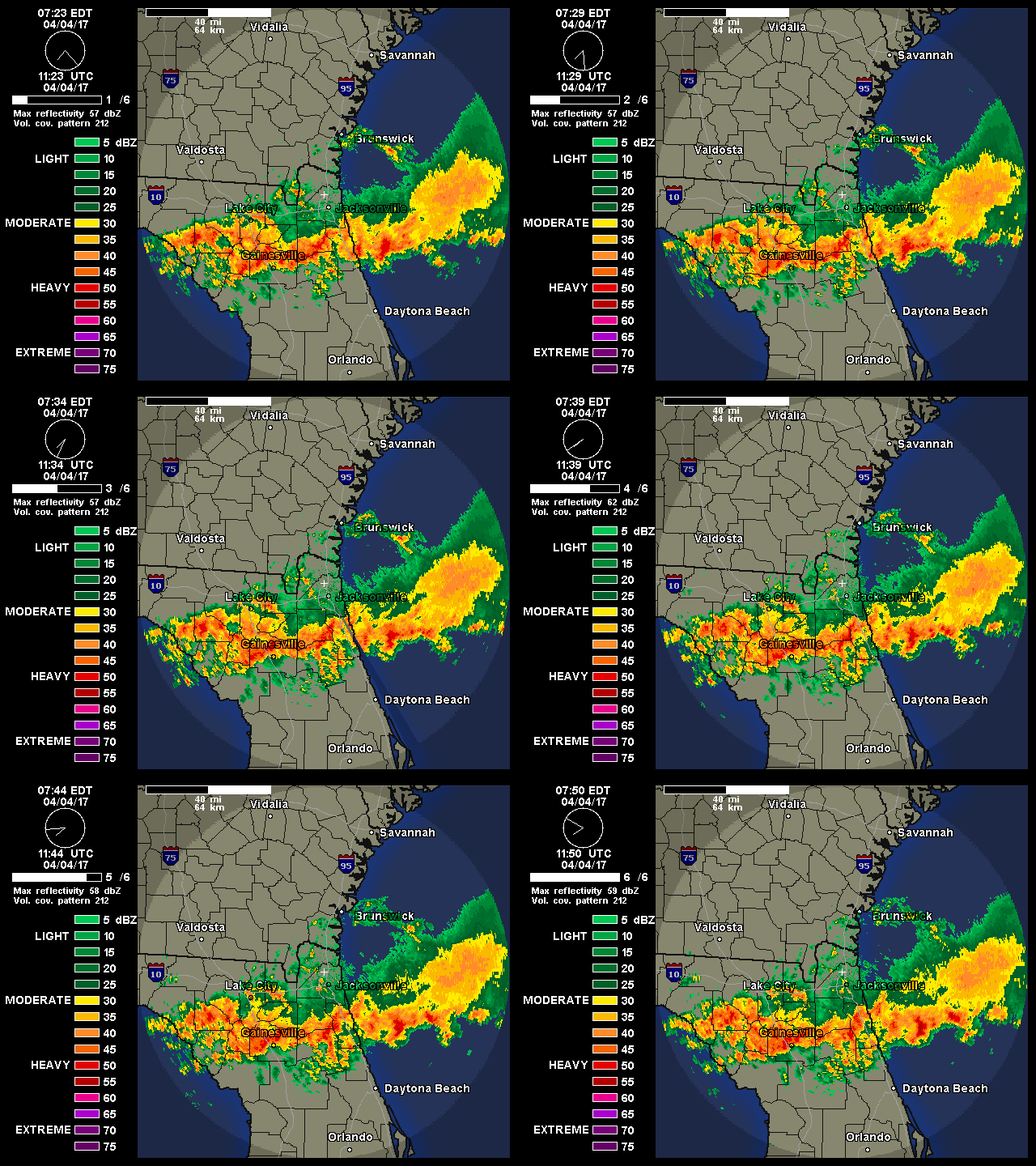
A classic example of convergence occured across portions of southern St. Johns and Flagler counties yesterday where we have a stalled out coastal trough just off the Northeast Florida coast and an onshore flow. A band of rain just set up right on top of those areas the entire day and into the night. In paticular, the Palm Coast area was hard hit with flooding, where they have received over 12 inches total as of early this morning. When you have a set-up where the pattern is stagnant, and where deep moisture and ample lift converge over a particular localized area, the potential for extreme rainfall can occur and that's exactly what has occured there.

This also happened just a bit farther down the coast in the Daytona Beach area, where over 8 inches of rain and flooding was reported on Thursday, discussed earlier on the previous page of this thread. JAX radar currently still shows a convergent rain band sitting over the Palm Coast area. They will likely see more heavy rainfaill into the afternoon.

Image

More widespread rain is on the way beginning late Sunday into Monday -Tuesday across the region period as another Low Pressure area will move in from the Gulf Coast. It has been an extremely wet September and it appears the month will end that way as well.

EDIT: Just after I made this post, the NWS Jax office at 11 a.m. just issued a Flood watch for the above areas noted (St. Johns and Flagler counties) until 8:00 p.m. tonight. Definitely the right call to make considering the localized flooding which has already occured in those areas.
0 likes   
NEVER, EVER SAY NEVER in the tropics and weather in general, and most importantly, with life itself!!

________________________________________________________________________________________

Fay 2008 Beryl 2012 Debby 2012 Colin 2016 Hermine 2016 Julia 2016 Matthew 2016 Irma 2017 Dorian 2019

psyclone
S2K Supporter
S2K Supporter
Posts: 4779
Joined: Wed Aug 24, 2005 9:04 pm
Location: palm harbor fl

#8522 Postby psyclone » Sat Sep 27, 2014 11:33 am

we're wetter here than we've been all Summer. the heart of the rainy season (July August) was a bust here so the September drenching has been a blessing. Flood watch for west central Florida for today as well. Let 'er dump.
0 likes   

User avatar
tropicwatch
Category 5
Category 5
Posts: 3414
Age: 61
Joined: Sat Jun 02, 2007 10:01 am
Location: Panama City Florida
Contact:

#8523 Postby tropicwatch » Sat Sep 27, 2014 12:02 pm

Looks like the rain that was forecast for the panhandle this weekend is slowly making its way to the coast.

Image
0 likes   
Tropicwatch


Agnes 72', Eloise 75, Elena 85', Kate 85', Charley 86', Florence 88', Beryl 94', Dean 95', Erin 95', Opal 95', Earl 98', Georges 98', Ivan 2004', Arlene 2005', Dennis 2005', Ida 2009' Debby 2012' Irma 2017' Michael 2018'

psyclone
S2K Supporter
S2K Supporter
Posts: 4779
Joined: Wed Aug 24, 2005 9:04 pm
Location: palm harbor fl

#8524 Postby psyclone » Sat Sep 27, 2014 7:53 pm

west central and southwest Florida is being inundated this evening. there were already a number of river flood warnings posted before today/tonight's dump so more may be added and crests revised higher.
0 likes   

User avatar
tropicwatch
Category 5
Category 5
Posts: 3414
Age: 61
Joined: Sat Jun 02, 2007 10:01 am
Location: Panama City Florida
Contact:

#8525 Postby tropicwatch » Sat Sep 27, 2014 11:40 pm

Tonight tomorrow and Monday is not looking too good for the panhandle.

Image
0 likes   
Tropicwatch


Agnes 72', Eloise 75, Elena 85', Kate 85', Charley 86', Florence 88', Beryl 94', Dean 95', Erin 95', Opal 95', Earl 98', Georges 98', Ivan 2004', Arlene 2005', Dennis 2005', Ida 2009' Debby 2012' Irma 2017' Michael 2018'

User avatar
StormingB81
S2K Supporter
S2K Supporter
Posts: 5676
Age: 44
Joined: Thu Aug 27, 2009 1:45 am
Location: Rockledge, Florida

#8526 Postby StormingB81 » Mon Sep 29, 2014 9:20 am

Flood Watch

until 9:00 p.m. Tuesday, Sept. 30, 2014
INLAND VOLUSIA-NORTHERN LAKE-ORANGE-SEMINOLE-SOUTHERN BREVARD-
OSCEOLA-INDIAN RIVER-OKEECHOBEE-ST. LUCIE-MARTIN-COASTAL VOLUSIA-
SOUTHERN LAKE-NORTHERN BREVARD-
INCLUDING THE CITIES OF...DE LAND...LEESBURG...ORLANDO...
SANFORD...MELBOURNE...PALM BAY...KISSIMMEE...ST CLOUD...
VERO BEACH...OKEECHOBEE...FORT PIERCE...HOBE SOUND...
DAYTONA BEACH...CLERMONT...TITUSVILLE
344 AM EDT MON SEP 29 2014

...FLOOD WATCH IN EFFECT FROM NOON EDT TODAY THROUGH TUESDAY
EVENING...

THE NATIONAL WEATHER SERVICE IN MELBOURNE HAS ISSUED A

* FLOOD WATCH FOR EAST CENTRAL FLORIDA...INCLUDING THE FOLLOWING
AREAS...LAKE...ORANGE...SEMINOLE...VOLUSIA...OSCEOLA...BREVARD...
INDIAN RIVER...ST. LUCIE...MARTIN AND OKEECHOBEE.

* FROM NOON EDT TODAY THROUGH TUESDAY EVENING

* DEEP MOISTURE AND AN UPPER LEVEL DISTURBANCE ALOFT MOVING
EASTWARD TOWARD NORTH FLORIDA WILL ALLOW NUMEROUS SHOWERS AND
THUNDERSTORMS TO DEVELOP ACROSS EAST CENTRAL FLORIDA THIS
AFTERNOON. SHOWERS AND STORMS ARE EXPECTED TO PRODUCE HEAVY
RAINFALL AMOUNTS OF TWO TO THREE INCHES WITH SOME AREAS SEEING
HIGHER AMOUNTS WHERE STORMS MOVE OVER THE SAME AREAS. THIS MAY
OCCUR ALONG THE COASTAL COUNTIES IN THE LATE AFTERNOON INTO THE
EVENING TODAY. THE THREAT FOR LOCALLY HEAVY RAINFALL IS EXPECTED
TO CONTINUE ON TUESDAY AS A FRONTAL BOUNDARY DROPS INTO CENTRAL
FLORIDA AND FOCUSES ANOTHER ROUND OF SHOWERS AND STORMS WITH
HEAVY RAIN. TWO DAY RAINFALL ACCUMULATIONS MAY REACH FOUR TO
SIX INCHES IN ISOLATED SPOTS.

* ADDITIONAL HEAVY RAINFALL WOULD BRING POTENTIAL FLOODING TO
ROADWAYS...AND LOW-LYING AND POOR DRAINAGE AREAS. AREAS THAT
HAVE RECEIVED HEAVY RAINFALL OVER THE PAST WEEK WILL BE
ESPECIALLY VULNERABLE TO FLOODING SHOULD HEAVY RAIN DEVELOP IN
YOUR AREA. SMALLER CREEKS AND RIVERS ALREADY AT ELEVATED LEVELS
MAY SEE RAPID RISES OF WATER WITH HEAVY RAINFALL LEADING TO THE
POTENTIAL FOR FLOODING.

PRECAUTIONARY/PREPAREDNESS ACTIONS...

A FLOOD WATCH MEANS THERE IS A POTENTIAL FOR FLOODING BASED ON
CURRENT FORECASTS.

YOU SHOULD MONITOR THE LATEST FORECASTS AND BE ALERT FOR POSSIBLE
FLOOD WARNINGS. THOSE LIVING IN AREAS PRONE TO FLOODING SHOULD BE
PREPARED TO TAKE ACTION SHOULD FLOODING DEVELOP.
0 likes   

TheStormExpert

#8527 Postby TheStormExpert » Mon Sep 29, 2014 1:43 pm

Seems kind of like early spring out there today here in Palm Beach County with an 80% chance of T-Storms but basically confined to the the very late afternoon/evening to overnight timeframe due to the thunderstorm action expected to be enhanced by a developing low pressure in the NE GoM and Cool front that is expected to stall north of South Florida. Days like this early on in fall (only late September) make you wonder if folks here in all of Florida could be in for a very interesting winter ahead, though extreme cold like the winter months of 2010 seem unlikely at the moment.
0 likes   

TheStormExpert

#8528 Postby TheStormExpert » Mon Sep 29, 2014 8:22 pm

Image

Image

Image

Image
0 likes   

User avatar
northjaxpro
S2K Supporter
S2K Supporter
Posts: 8900
Joined: Mon Sep 27, 2010 11:21 am
Location: Jacksonville, FL

#8529 Postby northjaxpro » Mon Sep 29, 2014 9:53 pm

Yep, another wet day across the state. Just measured a total of just under 2 1/4 inches of rainfall for today at my locale through 10:00 tonight.

Grand total of rainfall now just over 15 inches at my locale for the month. There is a chance of more rain later tonight into early tomorrow morning as a surface trough drops south through north Florida trailing from a Low Pressure area developing off the coast of GA late tonight. Drier air will filter into the North Florida area on Tuesday and hopefully chase the rain away for a couple of days.

Next chance of rain will come on Friday into early Saturday as it appears the first significant cold front of this early Autumn season will enter into the Southeast U.S. region this weekend. By Sunday, the first real taste of Autumn will arrive into North Florida. It is early right now and this will fluctuate as the week progresses, but currently EURO is indicating temps possibly to dip as low as the upper 40s-low 50s across the normally cooler regions of the panhandle areas, i.e. Crestview by Sunday morning, with 50s indicated across the remaining portions of North Florida.

Yes! Bring on the cooler weather as I am really looking forward to it coming for sure!
0 likes   
NEVER, EVER SAY NEVER in the tropics and weather in general, and most importantly, with life itself!!

________________________________________________________________________________________

Fay 2008 Beryl 2012 Debby 2012 Colin 2016 Hermine 2016 Julia 2016 Matthew 2016 Irma 2017 Dorian 2019

asd123
Category 1
Category 1
Posts: 265
Joined: Tue Sep 06, 2011 7:06 pm
Location: Orlando, Florida

Re: Florida Weather

#8530 Postby asd123 » Tue Sep 30, 2014 8:12 pm

Central Florida seems to be getting their first front that will bring drier and much cooler weather for Saturday and Sunday (especially nights). News stations for Orlando forecast mid to upper 60s lows as the coldest, while weather.com forecasts low 60s to upper 50s. GFS has been consistently forecasting mid-upper 50s. Looks to be great :D

Question is: This event is not that far out (4-5 days) and the news stations seem to be the warmest (mid to upper 60's) while weather.com and some of the individual models seem to think otherwise. Why is this so?
0 likes   
This post is NOT AN OFFICIAL FORECAST and should not be used as such. It is just the opinion of the poster and may or may not be backed by sound meteorological data. It is NOT endorsed by any professional institution including storm2k.org. For Official Information please refer to the NHC and NWS products.

User avatar
Ntxw
Storm2k Moderator
Storm2k Moderator
Posts: 22818
Joined: Wed Oct 21, 2009 6:34 pm
Location: DFW, Texas

Re: Florida Weather

#8531 Postby Ntxw » Tue Sep 30, 2014 11:35 pm

NDG wrote::uarrow: Looking back at recent El Nino years it goes either way, at least for the Orlando area. Winter Temps during El Nino '09/'10 was well below average as mentioned earlier due to the -NAO, IMO.
'06/'07 was above average, 04/'05 slightly above average, '02/'03 below average Dec-Jan but above average Feb & March.
Interesting that temps during the Super El Nino '97/'98 were near average over all with not one single day of freezing temps officially in the Orlando area.
If you go back to previous years' NAO index you can see that the NAO index overall dictates the temps for central FL at the end not so much El Nino conditions.


Your analysis of the NAO and Florida winter is spot on. Two of the most severe -AO/NAO is 1976 and 2009/2010. 2002-2003 is there as well but weaker than the previous two. I agree this is a more important index than ENSO (for temperatures) in the sunshine state as ENSO is more of the driver for precipitation in this part of the world during the colder months.
0 likes   
The above post and any post by Ntxw is NOT an official forecast and should not be used as such. It is just the opinion of the poster and may or may not be backed by sound meteorological data. It is NOT endorsed by any professional institution including Storm2k. For official information, please refer to NWS products.

  Help support Storm2K!
Help Support Storm2K

TheStormExpert

#8532 Postby TheStormExpert » Wed Oct 01, 2014 6:38 am

Very interesting discussion this morning from our local NWS Office here in Miami, FL concerning the potential cool front or fronts as they will say! :D


AREA FORECAST DISCUSSION
NATIONAL WEATHER SERVICE MIAMI FL
406 AM EDT WED OCT 1 2014

HIGHLIGHTS:
* TYPICAL AFTERNOON TSTORM DEVELOPMENT THROUGH SATURDAY, FOCUSING
INTERIOR AND EAST COAST METRO.
* FIRST TASTE OF FALL (SOUTH FL STYLE) LOOKING MORE LIKELY BY
SUNDAY!


.DISCUSSION...A SURFACE TROUGH LIES ACROSS CENTRAL FL, PLACING
SOUTH FL IN A MOIST W-SW WIND FLOW AGAIN TODAY AND THIS WILL
CONTINUE THROUGH SATURDAY. SO AM EXPECTING A TYPICAL DIURNAL
PATTERN OF CONVECTION, FAVORING THE INTERIOR AND EAST COAST GIVEN
THE WESTERLY COMPONENT OF THE WIND FIELDS. THE LOWER LEVEL WINDS
TODAY STILL LOOK JUST BREEZY ENOUGH TO PREVENT A FULL FLEDGED
ATLANTIC SEA BREEZE FROM DEVELOPING, BUT WINDS DO LOOK TO BACK TO
A MORE SOUTHERLY DIRECTION THIS AFTERNOON, PROVIDING ENOUGH
CONVERGENCE TO ACTIVATE NUMEROUS THUNDERSTORMS. THE MAIN IMPACTS
WILL BE LIGHTNING STRIKES ALONG WITH THE POTENTIAL FOR ISOLATED
STREET FLOODING WHERE THE HEAVIEST STORMS DEVELOP. THIS SIMILAR
PATTERN WILL REPEAT ITSELF THROUGH THE FIRST HALF OF THE UPCOMING
WEEKEND AS PWATS REMAIN NEAR 2 INCHES IN A TYPICALLY UNSTABLE
ATMOSPHERE.

A SIGNIFICANT CHANGE IN THE WEATHER IS LOOKING MORE LIKELY FOR THE
LATER PART OF THE WEEKEND AS NOW BOTH GFS AND ECMWF ARE SENDING THE
FIRST STRONG COLD FRONT OF THIS FALL SEASON ACROSS SOUTH FL
SATURDAY NIGHT AND OFF OUR COAST SUNDAY MORNING. GFS ENSEMBLES ARE
SUPPORTING THIS FROPA IDEA AS WELL...WITH THE AVERAGE OF THE
MEMBERS A DEGREE OR TWO BELOW THE OPERATIONAL GFS MOS SUNDAY AND
SUNDAY NIGHT. GIVEN THIS...HAVE TRENDED THE FORECAST COOLER SUNDAY
THROUGH TUESDAY. THIS WOULD BE A VERY NOTICEABLE CHANGE FROM THE
SULTRY HIGH DEWPOINTS WE`VE FELT SINCE MAY...WELL INTO THE 70S.
BEHIND THE FRONT, DEWPOINTS WILL FALL INTO THE 60S ON A NICE
NORTHERLY BREEZE. HIGHS ON SUNDAY ARE FORECAST TO BE ONLY IN THE
LOWER-MID 80S. LOWS ARE FORECAST TO DROP INTO THE 60S INTERIOR
AND GULF COAST BOTH SAT AND SUN NIGHT...AND LOWER 70S EAST COAST
METRO WITH COMFORTABLE HUMIDITY...LETTING US KNOW THAT IT IS
INDEED FALL.


THIS IS PRETTY EARLY IN THE SEASON FOR A COLD FRONT, BUT THE
PATTERN OF AN AMPLIFIED TROUGH ACROSS THE EASTERN CONUS DOES NOT
SEEM TO WANT TO LET GO AS THE TROUGH CONTINUES RE-ESTABLISHING
ITSELF EVEN AFTER TEMPORARY FLOW CHANGES. GIVEN THIS, AN EARLY
SEASON COLD FRONT ISN`T SHOCKING...AND IN FACT THE LONGER RANGE
GFS SHOWS ANOTHER COLD FRONT AS WE ENTER MID OCTOBER. COULD THIS
BE THE BEGINNING OF A PARADE OF COLD FRONTS? TOO EARLY TO SAY,
BUT I`M INCLINED TO BELIEVE SO GIVEN THE AFOREMENTIONED LOCKED
SYNOPTIC PATTERN.
/GREGORIA


If this dicussion verifys it COULD be a nice October (at through mid month) here in South Florida!
0 likes   

asd123
Category 1
Category 1
Posts: 265
Joined: Tue Sep 06, 2011 7:06 pm
Location: Orlando, Florida

Re: Florida Weather

#8533 Postby asd123 » Wed Oct 01, 2014 11:40 am

Holy moly: would you take a look at the teleconnections: (http://www.cpc.ncep.noaa.gov/products/p ... .sprd2.gif), (http://www.cpc.ncep.noaa.gov/products/p ... .sprd2.gif), (http://www.cpc.ncep.noaa.gov/products/p ... .sprd2.gif).
The AO and the NAO tank big time and the PNA becomes a little positive.

I know the effects of the positive/negative aspects of the teleconnections in general , but can someone tell me specifically what this could possibly mean for Florida in the coming days?
0 likes   
This post is NOT AN OFFICIAL FORECAST and should not be used as such. It is just the opinion of the poster and may or may not be backed by sound meteorological data. It is NOT endorsed by any professional institution including storm2k.org. For Official Information please refer to the NHC and NWS products.

JonathanBelles
Professional-Met
Professional-Met
Posts: 11430
Age: 35
Joined: Sat Dec 24, 2005 9:00 pm
Location: School: Florida State University (Tallahassee, FL) Home: St. Petersburg, Florida
Contact:

#8534 Postby JonathanBelles » Wed Oct 01, 2014 12:11 pm

Cold air is on the way (for early October). Temperatures in Tallahassee did not bottom out in the 50s in all of September. Temperatures this weekend are heading for the upper 40s and models have been trending cooler with each run.
0 likes   

asd123
Category 1
Category 1
Posts: 265
Joined: Tue Sep 06, 2011 7:06 pm
Location: Orlando, Florida

Re:

#8535 Postby asd123 » Wed Oct 01, 2014 12:27 pm

JonathanBelles wrote:Cold air is on the way (for early October). Temperatures in Tallahassee did not bottom out in the 50s in all of September. Temperatures this weekend are heading for the upper 40s and models have been trending cooler with each run.


Those tankings and rise of the PNA would occur around the 8th of October, not the 5th and 6th when this current cool down is coming. I was wondering what are the implications of the perfect blend of teleconnections would which would occur around the 8th of October, not the 5th or 6th.
0 likes   
This post is NOT AN OFFICIAL FORECAST and should not be used as such. It is just the opinion of the poster and may or may not be backed by sound meteorological data. It is NOT endorsed by any professional institution including storm2k.org. For Official Information please refer to the NHC and NWS products.

User avatar
northjaxpro
S2K Supporter
S2K Supporter
Posts: 8900
Joined: Mon Sep 27, 2010 11:21 am
Location: Jacksonville, FL

Re: Re:

#8536 Postby northjaxpro » Wed Oct 01, 2014 5:35 pm

asd123 wrote:
JonathanBelles wrote:Cold air is on the way (for early October). Temperatures in Tallahassee did not bottom out in the 50s in all of September. Temperatures this weekend are heading for the upper 40s and models have been trending cooler with each run.


Those tankings and rise of the PNA would occur around the 8th of October, not the 5th and 6th when this current cool down is coming. I was wondering what are the implications of the perfect blend of teleconnections would which would occur around the 8th of October, not the 5th or 6th.


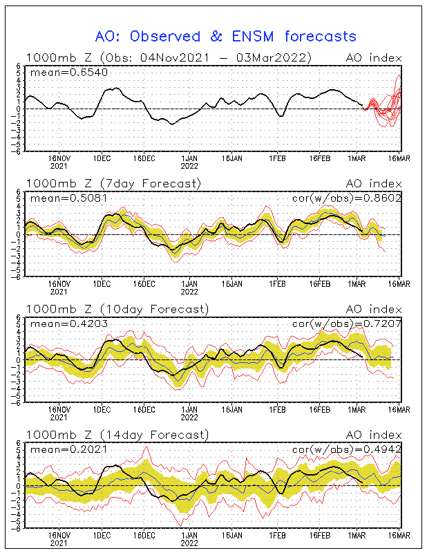
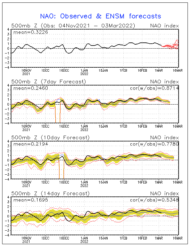
Well, the long range GFS extending out 10 days is indicating more cooler than normal weather for much of the Eastern CONUS and possibly down into Florida, especially for the period from Oct 10-12. It appears the upper level troughing across the Eastern U.S. will remain in place, which would mean we would have cold fronts coming down for a period of time diving down from Canada, and bringing in some rather cold air . Observing the ENSM forecasts, the Arctic Oscillation and North Atlantic Oscillation is forecast to tank considerably negative, and should that verify, we may be seeing mighty cool temps for early -mid October heading in our direction.

Image


Image
Last edited by northjaxpro on Wed Oct 01, 2014 5:57 pm, edited 2 times in total.
0 likes   
NEVER, EVER SAY NEVER in the tropics and weather in general, and most importantly, with life itself!!

________________________________________________________________________________________

Fay 2008 Beryl 2012 Debby 2012 Colin 2016 Hermine 2016 Julia 2016 Matthew 2016 Irma 2017 Dorian 2019

User avatar
northjaxpro
S2K Supporter
S2K Supporter
Posts: 8900
Joined: Mon Sep 27, 2010 11:21 am
Location: Jacksonville, FL

Re:

#8537 Postby northjaxpro » Wed Oct 01, 2014 5:42 pm

JonathanBelles wrote:Cold air is on the way (for early October). Temperatures in Tallahassee did not bottom out in the 50s in all of September. Temperatures this weekend are heading for the upper 40s and models have been trending cooler with each run.


That's correct Jonathan. Temps have trended cooler with each GFS and EURO run since yesterday. Also, latest models now showing possibly mid 40s across portions of the panhandle and upper 40s Tallahassee and Big Bend region on Sunday morning, and upper 40s- to lower 50s across interior Northeast Florida.
0 likes   
NEVER, EVER SAY NEVER in the tropics and weather in general, and most importantly, with life itself!!

________________________________________________________________________________________

Fay 2008 Beryl 2012 Debby 2012 Colin 2016 Hermine 2016 Julia 2016 Matthew 2016 Irma 2017 Dorian 2019

User avatar
NDG
S2K Supporter
S2K Supporter
Posts: 15473
Joined: Sun Jul 09, 2006 10:14 pm
Location: Orlando, FL

Re: Florida Weather

#8538 Postby NDG » Wed Oct 01, 2014 6:11 pm

I am not a fan of cold weather but even I am excited about the "cooler" and much drier air coming to the Orlando area this weekend, I have had enough of this very humid & wet pattern we have been.
0 likes   

User avatar
northjaxpro
S2K Supporter
S2K Supporter
Posts: 8900
Joined: Mon Sep 27, 2010 11:21 am
Location: Jacksonville, FL

#8539 Postby northjaxpro » Wed Oct 01, 2014 6:31 pm

Finished the month of September with a total measurement of just under 16 inches of rainfall at my locale. It was a ridiculously wet month for sure. This is good in that we will now typically enter our dry season now right through the winter months here across the peninsula. Now, if El Nino is to come to fruition this winter, then it is possible we may see above normal precip continuing. This remains to be seen of course and we will know as time progresses regarding if some sort of El Nino will develop. I will say the signs of recent sure look like we will have some form of it imo.

I am just happy that cooler and drier air is on the way here in the short term and hopefully this will allow my locale to finally dry out for a change! Also, the mosquitos are really bad with all this rain, so we need some cool and drier weather to rid some of them for sure!
0 likes   
NEVER, EVER SAY NEVER in the tropics and weather in general, and most importantly, with life itself!!

________________________________________________________________________________________

Fay 2008 Beryl 2012 Debby 2012 Colin 2016 Hermine 2016 Julia 2016 Matthew 2016 Irma 2017 Dorian 2019

asd123
Category 1
Category 1
Posts: 265
Joined: Tue Sep 06, 2011 7:06 pm
Location: Orlando, Florida

Re: Florida Weather

#8540 Postby asd123 » Wed Oct 01, 2014 7:26 pm

northjaxpro: Yeah, my location in Orlando received a lot of rain and so did the central, parts of northern south Florida, and northern Florida. Even the local news mentioned it. Record rainfall and flooding happened in Central Florida. Central and Northern Florida are in for a nice treat this weekend. Modest and noticeable cooldown from the summer heat and humidity will be nice and rewarding. After that like you said, we might be in for some very cold weather :cold: (relative to average) should those teleconnections verify and don't forget the super typhoon recurving :cheesy:

Question: I know how to display an image with a post, but I am really scared about committing copyright infringement. I see images with replies on this forum a lot. Can someone please tell me what's considered copyright infringement and what's not?
0 likes   
This post is NOT AN OFFICIAL FORECAST and should not be used as such. It is just the opinion of the poster and may or may not be backed by sound meteorological data. It is NOT endorsed by any professional institution including storm2k.org. For Official Information please refer to the NHC and NWS products.


Return to “USA & Caribbean Weather”

Who is online

Users browsing this forum: No registered users and 100 guests