
But yes, the GFS did trended colder from its medium range forecast to the short range.
Florida Weather
Moderator: S2k Moderators
Forum rules

The posts in this forum are NOT official forecast and should not be used as such. They are just the opinion of the poster and may or may not be backed by sound meteorological data. They are NOT endorsed by any professional institution or STORM2K.
Re: Florida Weather
But yes, the GFS did trended colder from its medium range forecast to the short range.
0 likes
-
northjaxpro

- S2K Supporter

- Posts: 8900
- Joined: Mon Sep 27, 2010 11:21 am
- Location: Jacksonville, FL
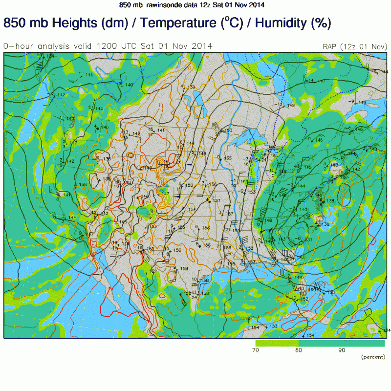
The dry secondary, re-enforcing cold front pushed through the Jax area just past 4 a.m this morning and the winds have been really howling out there. Had a wind gust up to 38 mph within the past hour, with sustained winds of 20-25. Wind advisory in effect today with a intense pressure gradient with Arctic High dome currently centered over Iowa dropping southeast and a developing Low pressure system across the South Carolina midlands. An anomulously deep upper trough over the Eastern CONUS is still sharpening with the lowest 500 mb heights still yet to reach the region.
Currently 46 degrees at my locale and temps still falling and will drop probably a couple of more degrees as very strong cold air advection has commenced. It will be an extremely windy and cold day as max temps today will only reach the mid - upper 50s at best today, despite the ample sunshine. There is a good chance that a record low maximum may either get tied or broken toiday for November 1. The record is 56 degrees.
We are headed for coldest temps thus far of the autumn season the next couple of mornings as the Cold High Pressurw Dome will sink south into the Tennessee Valley area by tomorrow morning. This will relax the pressure gradient to relax and winds to subside. However, with the High center still north of the peninsula, there should be enough wind to keep mixing the surface. This should keep freezing temps and frost to not happen across the North Florida tonight, but temps will be well down into the 30s tomorrow morning at my locale and across all of North Florida.
Temps will drop into the low-mid 40s across the central peninsula and down to upper 40s all the way down to about Lake Okechobee by tomorrow morning. Monday morning will be the coldest morning as the High center will be a bit closer to the area as the models are hinting it to be centered over South Carolina. This will bring radiational cooling conditions over the region with very light/calm wind across interior areas of North Florida. A good chance of seeing temps near the freeze mark, especially over the Suwannee River Valley and Big Bend region. Also, a good chance of seeing frost across North Florida on Monday morning as well.
The moderation with the return flow will start on Monday as the cold High Pressure dome moves out to the east to warm us back up. Observing the long range models, it appears that the NAO and AO finally look to go into the positive stage, so milder weather should take hold at least into the middle portions of November.
But for now, Old Man Winter has decided to give us a nice, early taste of unseasonably cold on the first day of November. Enjoy the crisp, chilly weather folks this weekend.
Last edited by northjaxpro on Sat Nov 01, 2014 8:00 am, edited 1 time in total.
0 likes
NEVER, EVER SAY NEVER in the tropics and weather in general, and most importantly, with life itself!!
________________________________________________________________________________________
Fay 2008 Beryl 2012 Debby 2012 Colin 2016 Hermine 2016 Julia 2016 Matthew 2016 Irma 2017 Dorian 2019
________________________________________________________________________________________
Fay 2008 Beryl 2012 Debby 2012 Colin 2016 Hermine 2016 Julia 2016 Matthew 2016 Irma 2017 Dorian 2019
-
northjaxpro
- S2K Supporter
- Posts: 8900
- Joined: Mon Sep 27, 2010 11:21 am
- Location: Jacksonville, FL
Yeah, EURO has done a great job all week with the advertisement of this cold snap gatorcane.
BTW, it bottomed out at 44 degrees for the morning low at my home locale. Now back at 46.2 degrees at this time and winds NW sustained 20 mph with gusts to 30 mph at times. Wind chill index currently in the upper 30s. Brrr!! The Florida-Georgia game is going to a cold one here later today with kickoff temp around 55 degrees with the brisk winds continuing.
BTW, it bottomed out at 44 degrees for the morning low at my home locale. Now back at 46.2 degrees at this time and winds NW sustained 20 mph with gusts to 30 mph at times. Wind chill index currently in the upper 30s. Brrr!! The Florida-Georgia game is going to a cold one here later today with kickoff temp around 55 degrees with the brisk winds continuing.
0 likes
NEVER, EVER SAY NEVER in the tropics and weather in general, and most importantly, with life itself!!
________________________________________________________________________________________
Fay 2008 Beryl 2012 Debby 2012 Colin 2016 Hermine 2016 Julia 2016 Matthew 2016 Irma 2017 Dorian 2019
________________________________________________________________________________________
Fay 2008 Beryl 2012 Debby 2012 Colin 2016 Hermine 2016 Julia 2016 Matthew 2016 Irma 2017 Dorian 2019
Re:
gatorcane wrote:northjaxpro, nice post above. Even down in South Florida it's feeling quite chilly and the secondary cold front has yet to come through. The ECMWF did a nice job of forecasting this strong front its long-range runs.
Yes, it did a great job in its medium to long range forecast compared to the GFS but then it dropped it for a couple days during its medium range before going back to its original solution during the last 4 days or so.
0 likes
Wow, this is what I call one heck of a sharp trough, the kind of sharp troughs that bring the cold air down the FL Peninsula's Spine!!! Zero degrees C isotherm at H85 all the way down to north FL this morning!!!
By the way, is never that often that we see such troughs one on the west coast and one on the east coast at the same time, usually the west coast of the US usually see a nice warm ridge when there is such a sharp trough across the east coast of the US.
Edit: Regarding medium to long range sypnotic set up, not sure if we will see a true positive NAO and AO regime last for too long, already the GFS ensemble members are already all over the board in their long range, one thing for sure they agree is that the PNA will go way positive which could keep a trough pattern at least across the Great Lakes and NE US which could keep FL no warmer than average temps.
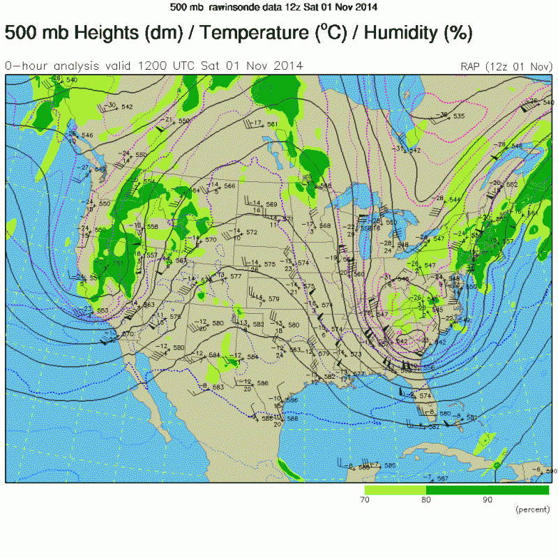
Last edited by NDG on Sat Nov 01, 2014 10:12 am, edited 1 time in total.
0 likes
-
northjaxpro
- S2K Supporter
- Posts: 8900
- Joined: Mon Sep 27, 2010 11:21 am
- Location: Jacksonville, FL
The pressure gradient here is just remarkable today. North-northwest winds sustaining 20 -25 mph all morning long with gusts into the 30s mph. Temps at my locale holding steady at 47 degrees currrenly with wind chill indices in the upper 30s.
Last edited by northjaxpro on Sat Nov 01, 2014 10:20 am, edited 1 time in total.
0 likes
NEVER, EVER SAY NEVER in the tropics and weather in general, and most importantly, with life itself!!
________________________________________________________________________________________
Fay 2008 Beryl 2012 Debby 2012 Colin 2016 Hermine 2016 Julia 2016 Matthew 2016 Irma 2017 Dorian 2019
________________________________________________________________________________________
Fay 2008 Beryl 2012 Debby 2012 Colin 2016 Hermine 2016 Julia 2016 Matthew 2016 Irma 2017 Dorian 2019
-
StormingB81

- S2K Supporter
- Posts: 5676
- Age: 44
- Joined: Thu Aug 27, 2009 1:45 am
- Location: Rockledge, Florida
-
northjaxpro
- S2K Supporter
- Posts: 8900
- Joined: Mon Sep 27, 2010 11:21 am
- Location: Jacksonville, FL
Currently 37.4 degrees at sunrise at my locale. As expected, the winds stayed up overnight to mix the air to keep temps from reaching near the freezing mark. As of this time of the post I am preparing, there are no Obs across the northern peninsula reporting the freeze mark. But, temps well down into the 30s are present across the northern peninsula. Hopefully, it won't be nearly as blustery today as it was yesterday. Winds gusted up to near 40 mph at times yesterday. But, the cold High Pressure dome will move in closer to us during today to relax the pressure gradient. Temps will again be cool today with Highs only around 60 today. BTW, had a max yesterday of 57 degrees.
The High Pressure will be centered over GA/SC by early tomorrow morning. It will be close enough to get the winds to get light enough to allow radiational cooling and I think some interior areas across the North Florida will get to near the freezing mark tomorrow morning, along with some frost.
Moderation trend will begin tomorrow as the Cold High edges eastward and the return flow will commence.
0 likes
NEVER, EVER SAY NEVER in the tropics and weather in general, and most importantly, with life itself!!
________________________________________________________________________________________
Fay 2008 Beryl 2012 Debby 2012 Colin 2016 Hermine 2016 Julia 2016 Matthew 2016 Irma 2017 Dorian 2019
________________________________________________________________________________________
Fay 2008 Beryl 2012 Debby 2012 Colin 2016 Hermine 2016 Julia 2016 Matthew 2016 Irma 2017 Dorian 2019
-
gatorcane

- S2K Supporter
- Posts: 23708
- Age: 48
- Joined: Sun Mar 13, 2005 3:54 pm
- Location: Boca Raton, FL
Got down into around 52F in my locale which is well below normal. Felt more like a mid-winter night across Southern FL after a front passes. Looks like the GFS and ECMWF are bringing yet another cold front through the FL peninsula for late Friday: Miami snippet:
THE END OF THE WEEK THE ECMWF AND THE GFS ARE IN GOOD AGREEMENT
DIGGING A HIGHLY AMPLIFIED H5 SHORTWAVE INTO THE APPALACHIAN
STATES. AS IT DOES...ANOTHER COLD FRONT IS EXPECTED TO PUSH INTO
SOUTH FLORIDA ON FRIDAY BRINGING SLIGHT CHANCES FOR SHOWERS WITH
IT. BOTH MODELS CLEAR THE FRONT THROUGH THE AREA LATE FRIDAY
RESULTING IN WHAT SHOULD BE ANOTHER COOL AND DRY WEEKEND FOR SOUTH
FLORIDA.
Also, check out these incredibly low dew points for this time of year that have pushed way down the spine of Florida deep into South FL and the Keys:
0 likes

Re: Florida Weather
Classic front is already rolling out. This would be an ordinary front for mid-winter down here.
Back to 83* by tuesday with a 63* low.
Back to 83* by tuesday with a 63* low.
0 likes

Re: Florida Weather
Really awesome cold spell for early November indeed!
Low was 44 Sunday morning at my locale, currently 57 degrees and falling fast once again tonight. Might drop below 50 degrees for a second night in a row here in the westernmost suburbs of Broward County. It has been below 70 degrees nonstop since Saturday afternoon when the second reinforcer front blew through. Should go above 70 tomorrow, Sunday's high here was 68. Woohoo
Low was 44 Sunday morning at my locale, currently 57 degrees and falling fast once again tonight. Might drop below 50 degrees for a second night in a row here in the westernmost suburbs of Broward County. It has been below 70 degrees nonstop since Saturday afternoon when the second reinforcer front blew through. Should go above 70 tomorrow, Sunday's high here was 68. Woohoo
0 likes
Georges '98, Irene '99, Frances '04, Jeanne '04, Katrina '05, Wilma '05, Gustav '08, Isaac '12, Matthew '16, Florence '18, Michael '18, Ian '22
-
gatorcane
- S2K Supporter
- Posts: 23708
- Age: 48
- Joined: Sun Mar 13, 2005 3:54 pm
- Location: Boca Raton, FL
The unseasonably cold air moving over the very warm Atlantic / Gulf stream waters has generated quite a cloud deck which is inching closer to SE Florida as winds at the 700MB layer are starting to swing to the NE. Eventually low-level winds will veer to the NE by tomorrow morning with these clouds moving into South Florida:

0 likes
Re: Florida Weather
The good thing is that the next trough is not going to dig as far south as the last one, we will cool down once again but nothing record breaking as the last one.
Sypnotic forecast show for the PNA to go way positive with no clear indication of what the AO and NAO will do, but the trend for them is to stay at least if not negative near neutral, so my thinking is that November will continue to be if not below average only near average, this could be one of the coolest November in a long time for FL if this pattern continues, IMO.
Sypnotic forecast show for the PNA to go way positive with no clear indication of what the AO and NAO will do, but the trend for them is to stay at least if not negative near neutral, so my thinking is that November will continue to be if not below average only near average, this could be one of the coolest November in a long time for FL if this pattern continues, IMO.
0 likes
-
TheStormExpert
Re: Florida Weather
NDG wrote:The good thing is that the next trough is not going to dig as far south as the last one, we will cool down once again but nothing record breaking as the last one.
Sypnotic forecast show for the PNA to go way positive with no clear indication of what the AO and NAO will do, but the trend for them is to stay at least if not negative near neutral, so my thinking is that November will continue to be if not below average only near average, this could be one of the coolest November in a long time for FL if this pattern continues, IMO.
Yes, the GFS has trended in yesterday evenings runs in stalling this next front over S. FL near Lake O, while the Euro continues with a clear pass and cooler/drier filtering throughout the whole state. Knowing how well the Euro has done this fall in calling these fronts/trougs in the long range, I am inclined to stick with its forecast and the Miami NWS Office is too.
0 likes
Re: Florida Weather
Man it was colder last night than Saturday night. Brrr. This front is as cold as mid-winter fronts and is unusual for November 3rd.
The warm up has begun.
The warm up has begun.
0 likes
-
gatorcane
- S2K Supporter
- Posts: 23708
- Age: 48
- Joined: Sun Mar 13, 2005 3:54 pm
- Location: Boca Raton, FL
Amazing what a wind shift will do in South Florida. Take West Palm Beach for example. I posted the last three observations below from the airport within 1 hour of each other. Temp has risen 11 degrees in 2 hours and 8 degrees in 1 hour with the wind shift off the warm Gulf stream current:
03 10:53 NE 15 G 21 10.00 Partly Cloudy SCT045 SCT250 76 53 45% 30.29 1025.7
03 09:53 N 6 10.00 Mostly Cloudy BKN048 BKN250 68 54 61% 30.29 1025.7
03 08:53 NW 9 10.00 Partly Cloudy SCT047 SCT250 65 52 63% 30.28 1025.4
http://www.srh.noaa.gov/data/obhistory/KPBI.html
I have seen even more dramatic shifts of 10, 15, and even 20 degrees when the winds shifts from NW to the NE.
0 likes
-
gatorcane
- S2K Supporter
- Posts: 23708
- Age: 48
- Joined: Sun Mar 13, 2005 3:54 pm
- Location: Boca Raton, FL
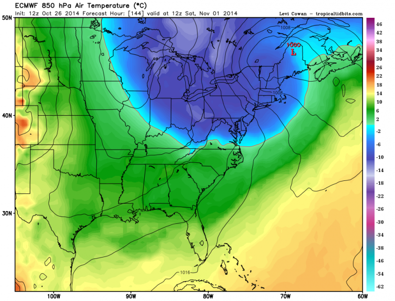
The 12Z ECMWF is showing well below normal temperatures for nearly the entire eastern half of the United States in it's long-range forecast by day 10, though the highest of these anomalies look to stay north of Florida for now. Seems that we are stuck in this Eastern CONUS trough pattern (pretty much had it the entire summer also) with the troughs just getting stronger and stronger as we head deeper into the fall.
For Florida could mean average to below average temperatures through at least the first half of November, if not all of November, as NDG points out.

For Florida could mean average to below average temperatures through at least the first half of November, if not all of November, as NDG points out.
0 likes
Return to “USA & Caribbean Weather”
Who is online
Users browsing this forum: No registered users and 143 guests